Eurasian Plate
One of Earth's major tectonic plates, covering most of Europe and northern Asia and extending into adjacent ocean basins; shapes mountain ranges, seismic zones, and continental configuration.
Overview
The Eurasian Plate is a major tectonic plate that underlies much of the landmass commonly called Eurasia. It carries most of Europe and northern Asia and extends beneath portions of adjacent oceans. As a rigid section of Earth's lithosphere, it participates in the global system of plate interactions that produce earthquakes, mountain building, and sea-floor spreading.
Image gallery
4 Images


Extent and composition
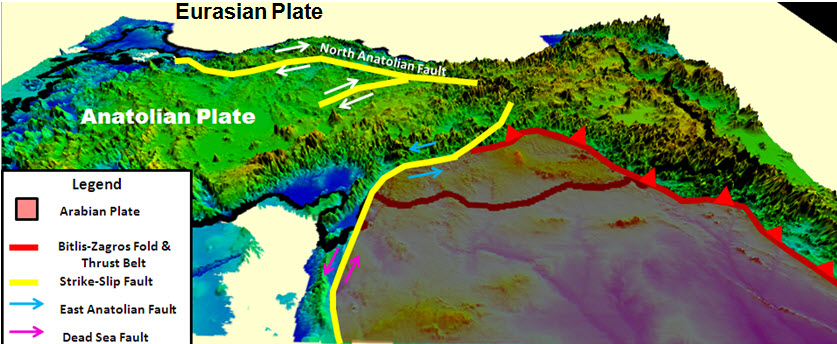
Unlike the cultural-geographic term Eurasia, the plate is a geologic entity that includes continental crust and stretches into oceanic crust westward and northward. It reaches toward the Mid-Atlantic Ridge in the west and toward the Gakkel Ridge in the Arctic north. At its margins the plate contacts several other major plates and a number of smaller microplates; some continental regions that might be expected on it—such as the Indian subcontinent and the Arabian Peninsula—are carried on adjacent plates.
Tectonic boundaries and notable features
The plate's boundaries are diverse. Where it meets the Indian Plate, a long history of collision has uplifted the Himalayas and the Tibetan Plateau. Along its eastern and northeastern margins, interactions with oceanic plates and smaller continental blocks produce subduction zones, volcanic arcs and complex fault systems. The plate also borders spreading centers such as the Mid-Atlantic Ridge and the Gakkel Ridge, which are sites of new oceanic crust formation.
Origins and geologic development
The Eurasian Plate formed through the assembly and rearrangement of older continental fragments over hundreds of millions of years. Regions that now belong to the plate were once parts of earlier supercontinents and smaller plates; plate motions since then have been driven by mantle convection, ridge push and slab pull processes. Over geologic time these movements have rearranged coastlines, created mountain chains, and altered ocean basins.
Significance and impacts
Because it underlies densely populated and historically important regions, the Eurasian Plate plays a central role in natural hazards and resource distribution. Its active margins generate earthquakes and volcanic activity, influence climate through orographic effects of mountain ranges, and control the distribution of sedimentary basins that host mineral and hydrocarbon resources. Studying the plate helps scientists assess seismic risk and reconstruct Earth’s geologic past.
Distinctions and related concepts
It is important to distinguish the geologic plate from the broader geographic term Eurasia. The plate includes both continental and adjacent oceanic crust and excludes some continental fragments carried by separate plates, such as the Indian subcontinent and parts of the Arabian region. In places the boundary is not a simple line but a mosaic of microplates and complex faults, so geologic maps sometimes subdivide the region into smaller tectonic blocks.
Key links and further reading
- Eurasia (broad geographic concept)
- Continents and continental plates
- Europe (region on the plate)
- Northern Asia (region on the plate)
- Indian subcontinent (separate plate)
- Chersky Range (eastern boundary area)
- Oceanic crust adjacent to the plate
- Mid-Atlantic Ridge (western spreading boundary)
- Gakkel Ridge (Arctic spreading center)
Questions and answers
Q: What is the Eurasian plate?
A: The Eurasian plate is a tectonic plate that includes most of the continent of Eurasia.
Q: What does the Eurasian plate consist of?
A: The Eurasian plate consists of the traditional continents of Europe and northern Asia.
Q: Which areas are not included in the Eurasian plate?
A: The Indian subcontinent, Arabia, and the area east of the Chersky Range in East Siberia are not included in the Eurasian plate.
Q: How large is the landmass included in the Eurasian plate?
A: The landmass included in the Eurasian plate is huge.
Q: Does the Eurasian plate include any oceanic crust?
A: Yes, the Eurasian plate includes oceanic crust west to the Mid-Atlantic Ridge and north to the Gakkel Ridge.
Q: What is the Mid-Atlantic Ridge?
A: The Mid-Atlantic Ridge is a geological feature that runs down the middle of the Atlantic Ocean.
Q: What is the Gakkel Ridge?
A: The Gakkel Ridge is a divergent tectonic boundary located underneath the Arctic Ocean.
Related articles
Author
AlegsaOnline.com Eurasian Plate Leandro Alegsa
URL: https://en.alegsaonline.com/art/32550