Euboea
![]()
Euboia and Euboea are redirections to this article. For other meanings, see Euboia (disambiguation).
Euboea (ancient Greek Εὔβοια Euboia, Latin Euboea; modern Greek Εύβοια (f. sg.), pronunciation: [ˈɛvia]) is the second largest Greek island after Crete, with an area of 3,660 km² and a population of about 220,000 (as of 2005). The capital is Chalkida (formerly Chalkis). The island is connected to the mainland by two bridges; one of them bridges the Euripos, the narrowest strait in the world with only 40 meters.
Euboea is an elongated island, about 175 kilometres long and 6 to 45 kilometres wide, with a total coastline of 678 kilometres. Along its entire length, the island is crossed by a mountain range that joins Thessaly in the northwest and continues southward through the islands of Andros, Tinos and Mykonos.
The island belongs to the region of Sterea Ellada (Central Greece). The regional district of Euboea also includes the island of Skyros, a small part of the mainland and a large number of rocky islands, such as the Petalian archipelago.
Name
Like most Greek islands, Euboea was formerly known by other names, for example as Μάκρις Makris, and Δολίχη Doliche, referring to the shape of the island, or as Ellopia, Aonia and Abantis after the tribes inhabiting it (see Abantes). The ancient and present name Εὔβοια is derived from εὖ 'good' and βοῦς 'cattle'. This gives the meaning 'land of well-fed cattle'.
In the Middle Ages, Byzantine authors used the names Chalkis and Euripos for the island (transferred from the name of the capital and the strait, respectively) in addition to Euboia. When the Venetians occupied the area in the 13th century, they called the island Negroponte.
Geography
Euboea is separated from the Greek mainland by the long Gulf of Euboea. It is believed that Euboea was originally part of the Greek mainland and was separated from it by an earthquake. Since the island lies near a fault line and, moreover, both Thucydides and Strabon report shaking of the northern part of the island, such a scenario is quite conceivable.
The strait between Euboea and the Greek mainland is called Euripos (Porthmós Evrípou) at Chalkida, where it is narrowest at only 40 metres. The unusually strong tidal changes at this point have attracted great interest since ancient times. The current changes its direction frequently and very suddenly, while its strength remains the same. The first bridge was built at this point in 410 BC, in the 21st year of the Peloponnesian War. The strait in the north - between the northern foothills of the island and the coast of Thessaly - is 2.4 kilometres wide at its narrowest point.
The largest mountains on the island are Dirphys (1745 m), Pyxaria (1341 m) in the northeast and Ochi (1394 m).
Besides the main town of Chalkida, there are a number of small towns: Karystos, Kymi, Psachna, Aliveri, Loutra Edipsou and Limni.

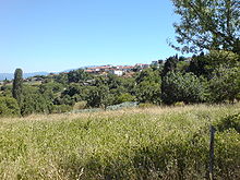
Typical landscape on the island

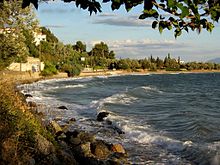
Coastal stretch in autumn

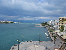
Beach promenade of Chalkida
Search within the encyclopedia