Eschweiler
This is the sighted version that was marked on April 16, 2021. There is 1 pending change that needs to be sighted.
![]()
This article is about the city of Eschweiler; for other meanings, see Eschweiler (disambiguation).
The city of Eschweiler [ˈɛʃˌvaɪlɐ] (from Latin Ascvilare, Eschweiler Platt Aischwiile, French (obsolete) Exvilliers) is a medium-sized regional city in the Städteregion Aachen. It is a fully developed medium-sized centre with one of the largest hospitals in the region, the seat of several authorities such as the Federal Police and regionally important cultural institutions as well as a carnival stronghold. Due to its central location and motorway connection, it forms a traffic junction in the city region. From Celtic times until the 20th century, mining and open-cast mining shaped the city. Worth seeing are the numerous castles and manor houses as well as the Inde meadows and the Blausteinsee lake.
The city of Eschweiler was awarded the German Sustainability Award for Cities and Municipalities in the category of medium-sized cities 2018.
It received its present form in 1972 through the incorporation of Dürwiß, Laurenzberg, Lohn and Weisweiler as well as the reintegration of Kinzweiler into the town of Eschweiler.
Geography
Location and landscape description
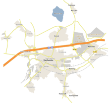
Eschweiler is located on the northern slope of the Eifel in the transition to the Jülich-Zülpicher Börde in the western Rhineland and thus in the immediate vicinity of the border triangle Germany-Netherlands-Belgium. The river Inde flows through the town centre and through the Pumpe-Stich and Weisweiler districts. Eschweiler is part of the industrial landscape of the Aachen coalfield and the Rhenish lignitefield of the Cologne Bay.
The almost circular urban area of Eschweiler is divided into three zones:
- The Inde valley runs through the middle of the city, with floodplains along the partly straightened and partly renaturalised Inde river.
- The northern half is part of a border landscape with the Blausteinsee (in the Indeland), wide fields and the golf course at Haus Kambach.
- The Voreifellandschaft lies in the south; it is characterised by heights and larger forests such as the Propsteier Wald, the Ichenberg, the Eschweiler Stadtwald, the Korkus, the Bovenberger Wald and the Halde Nierchen.
Geology
In the southern half of the urban area, claystones, siltstones and sandstones occur with coal seams, quartzites, conglomerates, limestones and dolomites from the Devonian and Carboniferous periods, of which quartzite as well as limestone and mudstone occur in economically significant quantities. Of the layers folded 300 million years ago, only a flat-wavy mountain body remains, which dips in a northerly direction under the loose rock fill of the Lower Rhine Bight. The northern half consists of up to 500 metres thick clays, silts and sands with lignite of the Tertiary. They are extensively covered by gravel sands of the glacial Meuse. The loose rocks are dislocated by faults that are still active today.
The soils in the northern part of the city were originally parabrown soils, but since the recultivation of the open-cast lignite mining they are mostly artificially applied loess and loess loam. Hard coal mining and opencast lignite mining left behind several heaps of tailings, which are now mostly used for forestry, such as the Black Mountain (250 m) in the city forest, the Nierchen heap (223 m) near Hücheln and Auf der Kippe (169 m) near Eschweiler-Ost. In the valley of the Inde river, floodplain soils have developed under the influence of periodic flooding and strong groundwater fluctuations: the Inde floodplains.
Primary aquifers in the Eschweiler urban area are the limestone and dolomite rocks and the gravelly-sandy deposits of the Meuse near the surface. In the southern part of the town area, the bedrock is classified as having very good bearing capacity, and the sands and gravels in the northern half are also able to absorb high construction loads. In the past, mining-related influences on structures occurred to a minor extent.
Since the Neolithic Age, Eschweiler coal sandstone - EKS for short - has been used for anvils, millstones and house construction.
Waters
The largest flowing body of water in Eschweiler is the Inde, which flows into the Rur near Jülich. Other streams are the Merzbach, the Omerbach, the Otterbach, the Saubach and numerous rivers. The largest standing water is the artificial Blausteinsee, followed by the Koppweiher in the Stadtwald. Other ponds are located in the Propsteier Wald, Stadtwald, Bovenberger Wald, at the IGP industrial and commercial park, in the Im Hasselt industrial estate and at Burgen and Mühlen.
The Inde runs for just under ten kilometres through the city area, with one motorway bridge, four railway bridges, seven footbridges (Aue, Jahnstraße, Wurstbrückchen Kochsgasse, Wollenweberstraße, Schlachthof, Wasserwiese, Am Mühlengraben Weisweiler) and 14 road bridges crossing it.
Climate
Eschweiler lies in the cool temperate to oceanic climate zone, in which humid winds from westerly directions from the North Sea prevail. Precipitation falls here at all times of the year, which is somewhat less in the lee of the Eifel than in the regions of the Lower Rhine. The winters are relatively mild and the summers relatively cool. The average annual temperature is 8 to 10 °C. With westerly winds, a light Föhn weather situation can develop in the lee of the Eifel.
| Monthly average precipitation for Eschweiler-Weisweiler
Source: German Weather Service - measured values 1961-1990 Precipitation: Eschweiler-Weisweiler | ||||||||||||||||||||||||||||||||||||||||||||||||||||||||||||||||||||||||||||||||||||||||||||||||||||||||||||||||||||||||
Extension of the urban area
The area of the city is 76.57 square kilometers. It is widest in east-west extension (9.8 km) and in north-south extension (10.7 km). The lowest point at 110 m above sea level is on the Inde near Weisweiler, the highest at 262.5 m at the Stadtwald; the average altitude, measured at the market, is 140 m.
Neighboring communities
(Small letters and italics are no longer independent parts of the neighbouring municipalities).
| Alsdorf Hoengen | Aldenhoven | Inden Frenz |
| Würselen Broichweiden |
| Langerwehe |
| Aachen | Stolberg (Rhld.) | Gressenich |
City breakdown
Eschweiler is divided into the 15 city districts (district number/number of inhabitants at the end of 2004) Stadtzentrum with Altstadt and Klee Oepe - (01/11,823), Dürwiß (08/7,190), Weisweiler/Hücheln/Wilhelmshöhe (10/6,028), Bergrath/Bohl/Volkenrath (12/5,539), Röthgen (03/4.796), Innenstadt mit Eschweiler-Ost/Vöckelsberg (02/4.681), Pumpe/Aue/Siedlung Waldschule (15/2.897), Stich (14/2.604), Röhe (04/2.336), Nothberg (11/2.159), Hastenrath/Scherpenseel (13/2,023), Kinzweiler (06/1,712), Hehlrath (07/1,285), St. Jöris (05/885) and Neu-Lohn/Fronhoven (09/857).

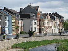
Wilhelminian style development on Indestraße (formerly Schützenstraße)

Outline of Eschweiler
Politics
On 25 May 2009, the city of Eschweiler was awarded the title "Place of Diversity" by the German government.
City Council and Mayor
→ Main article: Results of the local elections in Eschweiler
→ Main article: List of mayors of Eschweiler
See also: "Eschweiler" in the article: Results of the local elections in the Aachen city region
Nadine Leonhardt (SPD) was elected mayor in 2020 as successor to Rudi Bertram (SPD).
The municipal elections of 13 September 2020 resulted in the following distribution of seats in the Eschweiler City Council:
| Party/List | SPD | CDU | BASIS1 | Green | FDP | AfD | The Left | Total |
| Seats | 23 | 14 | 4 | 4 | 2 | 2 | 1 | 50 seats |
1BASIS: "BASIS - Citizens for Eschweiler" awareness group
Coat of arms and city colours
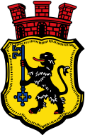
The coat of arms of the town of Eschweiler shows in gold a red-armed (red claws, red tongue) black lion holding a blue key in its paws. Above the escutcheon, in the head of the shield, is a red three-nined mural crown.
The lion is the heraldic animal of the Dukes of Jülich, the Petrus key indicates the relationship to the Cologne Cathedral Church. Eschweiler was mentioned in a document in 1216 as a court of the cathedral church and remained dependent on it for fiefdom until the 16th century. Saint Peter is the patron saint of the cathedral church. The mural crown reminds us that Eschweiler was a medieval market town with corresponding rights. The coat of arms goes back to a Schöffensiegel (seal of the aldermen) preserved on a document from 1490. The town of Eschweiler was granted permission to use the coat of arms on 13 December 1880.
The city colors and the flag of Eschweiler are black-yellow-blue according to the coat of arms. Black-yellow stands for the Duchy of Jülich, blue for the Petrus key. The city colours of Eschweiler were decided by the city council in 1914.
See also: List of coats of arms with the Jülich lion
Twinning
Since 4 May 1985 there has been a twinning arrangement with the southern English Borough of Reigate and Banstead, in honour of which the square in front of Eschweiler's main railway station was officially renamed Reigate & Banstead Square on 26 September 1989.
The town has also been twinned with the northern French town of Wattrelos since 1975.
Since 1 March 2019, the town of Eschweiler has also been twinned with the Upper Palatinate town of Sulzbach-Rosenberg.

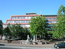
New town hall at Johannes-Rau-Platz

Coat of arms of the city of Eschweiler

Flag colours of the city of Eschweiler
Search within the encyclopedia
.svg.png)