Emden
![]()
The title of this article is ambiguous. For other meanings, see Emden (disambiguation).
Emden is a city in the northwest of Lower Saxony and the largest city in East Frisia. It is located at the mouth of the river Ems on the northern bank of the Dollart. With 49,874 inhabitants, Emden is the smallest of the independent cities in the state, ranking 21st among the cities in Lower Saxony, making it the second largest city on the Lower Saxony coast after Wilhelmshaven. The inhabitants are called Emder, the adjective is also so.
The city originated as a Frisian trading town around the year 800 and is still largely characterised by its seaport, which in the 20th century was the basis for the settlement of larger industrial companies such as the Nordseewerke shipyard and the Volkswagen factory. As a business location, the only district-free city in East Frisia has an outstanding significance for the region. The city has been a university location since 1973. Since 2007, the state planning of Lower Saxony has designated Emden as a medium-sized centre with upper-centre sub-functions.
In the 16th century, Emden was one of the most important sites of the Reformation, along with Geneva and Wittenberg. Among others, Johannes a Lasco, Albert Ritzaeus Hardenberg and Menso Alting worked in Emden. The baptism of 300 adults in an antechamber of the Great Church by Melchior Hofmann in 1530 marked the beginning of the Anabaptist movement in northwest Germany and the Netherlands. The Great Church was also a religious refuge for refugees from the Netherlands during the Reformation. The Synod of Emden (1571) was the first national synod of the Dutch Reformed. Because of this significance, the Council of the Community of Protestant Churches in Europe (CPCE), based in Vienna, awarded Emden the title of "Reformation City of Europe" in December 2013, the first place on the continent to do so.
Emden is also known as the birthplace of comedians Otto Waalkes and Karl Dall, who have shaped the East Frisian joke through their work. Otto" in particular has helped his hometown to greater fame through films and music albums. The art gallery in Emden is also of supra-regional importance.
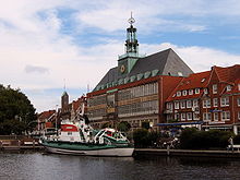
Emder city hall with council building in the foreground
Geography
Geographical location
Emden is located in the northwest of Germany in the historic landscape of East Frisia and is the westernmost seaport city in Germany. It is located on the northern edge of the estuary of the Ems into the North Sea, south of the city is also the bay Dollart. The port of Emden is 38 nautical miles from the mouth of the Ems at Borkum. At the Knock, which forms the westernmost point of the Emden city area, is the southwesternmost point of the East Frisian peninsula.
Nearby larger cities are Oldenburg (a good 70 kilometres to the east-southeast), Bremen (a good 110 kilometres to the east-southeast), Groningen (a good 50 kilometres to the west-southwest - the route by train or car is considerably longer, however, as the Dollart has to be bypassed) and Wilhelmshaven (a good 60 kilometres to the east-northeast).
The state planning of Lower Saxony designates Emden as a medium-sized centre with upper-central sub-functions. The catchment area varies depending on the function to be observed. As a shopping city, Emden essentially supplies the surrounding municipalities, some of them only partially, as there is competition here with the cities of Aurich and Leer. The latter have the advantage that their catchment area extends in all directions, while in the south and west of Emden the Ems and the Dollart form the natural boundary of the catchment area. The same applies to other services. As the largest city in East Frisia, Emden nevertheless has an important function in the retail trade of East Frisia despite its unfavourable location (as a shopping city).
As a place of work, on the other hand, the city has an outstanding importance for the entire region of East Frisia and partly beyond. The cultural programme is attended - at least for individual events, such as some concerts in the Nordseehalle - by guests who live in the surrounding area of Oldenburg, in central to southern Emsland or in the north-east of the Netherlands. In addition, Emden is often the destination of tourists who spend their holidays on the coast and come to see the city's cultural sights.
Land use
| Land use in 2005 | |
| Use | Area in ha |
| Built-up area | 3.484 |
| of which residential | 922 |
| thereof mixed building area | 135 |
| of which commercial building land | 1.738 |
| of which special construction areas (especially port facilities) | 690 |
| Public utility area | 113 |
| Traffic area | 267 |
| thereof road traffic | 141 |
| thereof stationary traffic | 2 |
| thereof railway facilities | 95 |
| of which air traffic | 31 |
| Green spaces | 683 |
| thereof parks | 281 |
| thereof allotment gardens | 67 |
| thereof sports fields | 97 |
| thereof cemeteries | 18 |
| thereof other green areas | 219 |
| Water surface | 770 |
| Agricultural area | 5.850 |
| Total area | 11.238 |
After extensive incorporations in 1945/46 (Larrelt, Harsweg, Uphusen) and 1972 (Twixlum, Wybelsum, Logumer Vorwerk, Widdelswehr, Jarßum, Petkum), agricultural land now accounts for 52 per cent of the city area (see table; now 61.1 per cent, as of 31 December 2014). Although this puts Emden pretty much in line with the national average, it has an above-average amount of agricultural land for an independent city. Within East Frisia as a whole, on the other hand (agricultural land of around 75 percent), Emden has a below-average share. The water area share of 6.85 percent (7.7 percent, as of December 31, 2014) is well above the national average of two percent, given the port and the large number of canals. Like all municipalities in the Marsch, Emden, on the other hand, has far below-average forest cover (1.24 percent, as of December 31, 2014). The largest contiguous forest area is the Emder Wall, a municipal forest established in the 1990s in the far north of Emden is still in the process of being created. So far, 71 hectares have been planted with around 450,000 trees, and the rows of trees and shrubs are to be thinned out at a later date.
Geology and soils
The geological subsoil of the city is determined by sediments from the Holocene. Due to its location on the Ems and Dollart rivers, Emden is one of the few municipalities on the East Frisian mainland that has no part of the Geest and therefore has no Pleistocene strata near the surface. The predominant landscape type is the marsh.
Large parts of the city area in the west of Emden were only diked in the 19th and 20th centuries and are considered very fertile. In addition, many agricultural areas in the east and west of the city were washed over with silt in the 20th century, which was obtained during dredging of the Ems and the port of Emden. After these areas were dried, they were again upgraded, as the silt is considered a valuable soil component. This practice is still continued today, currently (as of 2013) in the Wybelsum area.
The marshes of Emden cover the entire urban area with the exception of some eastern areas near Marienwehr and Uphusen as well as in the Borssumer to Petkumer Hammrich, where they occur in association with other soil types. Northeast of Uphusen and south of the Ems-Jade Canal as well as in the Borssumer Hammrich, pseudogley is found underlain by Kleimarsch. The southern part of the Uphusen district around the Uphuser Meer and the Bansmeer as well as the Petkumer Hammrich (approximately north of the Fehntjer Tief) consists of lowland moor with raw marsh overlay. Near Uphusen, areas were flooded with silt over several decades from 1954 onwards, then drained and - thus improved in terms of soil quality - returned to agricultural use. Northeast of Marienwehr, close to the Kleines Meer, lowland moor with bent marsh overlay is found. Another exception is the eastern part of the Emden harbour, which was poldered in the early 20th century and then artificially raised: it is called gley-regosol, because gley was used to raise the land.
The rest of the city consists of old marshes and young marshes. The youngest marsh soils are located in the Petkum dike foreland, where salt marshes are only washed over during particularly pronounced storm surges and otherwise pedogenesis (soil formation) has already begun. The area is a nature reserve. It belongs to the raw marsh (i.e. the youngest form of marsh), as does the Rysumer Nacken on the Knock, which was washed up in the 1970s and was incorporated in 1976.
Kalkmarsch and Kleimarsch are also classified as young marshes, the former being the more recent from a pedological point of view. In Emden, lime marshes are mostly found in those areas that have only been dyked in recent centuries. Apart from a narrow strip of limestone marsh immediately behind the Ems dyke from Borssum to Petkum, all limestone marsh soils are found in the west of the city, especially in the Larrelter and Wybelsumer polders, which were only dyked between 1912 and 1923, and in the Kaiser-Wilhelm polder, which was wrested from the Dollart in the late 19th century and on which the districts of Constantia and Port Arthur/Transvaal were formed. In addition, Kalkmarsch is found between Larrelt and Twixlum and in extension north of the latter district. Kleimarsch is much less represented in the Emden urban area, occurring in the west of the city mainly as a narrow "connecting strip" to the more southerly Kalkmarsch. The largest continuous strip of Kleimarsch runs roughly from Petkum via Borssum through the city centre and from there follows the Hinter Tief to the north. In places, however, this strip is barely more than a hundred metres wide.
The Altmarschen includes the Knickmarsch, which covers large parts of the northern and eastern urban area - i.e. the part of the marsh that represents the mature stage of soil development. The soils belong to the oldest marsh soils, lie (as is also evident in Emden) furthest away from the coast and have subsided in the course of soil formation. In parts of the urban area, for example at the farms Bartshausen near Wybelsum and Rote Scheune near Twixlum, the area lies below sea level. Knickmarsch is also found in the meadows north of Larrelt and east of Conrebbersweg, in the latter part of the town itself, but above all in the entire east of the town from an imaginary line Barenburg-Herrentor-Borssum - as long as it is not the associated (mixed) forms mentioned at the beginning near Marienwehr as well as in the Uphuser, Borssumer and Petkumer Hammrich.
The highest elevations are the artificial mound built in the Middle Ages, about 7.5 metres high, on which the town was founded, and the rubbish dump, a good 15 metres high, which has been converted into a landscape park since mid-2006.
Waters
Emden is a city of water. There are 865 hectares of water (as of 31 December 2014) within its borders, which corresponds to 7.7 percent of the total area. A good part of this consists of harbour basins, but around 150 kilometres of canals also run through the city area. Parts of the canal network are natural watercourses, while the majority have been artificially created - such as the Emder Stadtgraben, which together with the Emder Wall formed part of the medieval fortifications, or canals created for shipping such as the Treckfahrtstief, the Ems-Seitenkanal and the Ems-Jade-Kanal. In addition, two lakes, the Uphuser Meer and the Bansmeer, are located on the territory of the city of Emden, and the city borders another (Hieve and Kleines Meer, respectively). All lakes are connected by canals to the port of Emden and the East Frisian waterway network, although navigation is prohibited on the Bansmeer, which is designated as a nature reserve. The Hinter Tief and the Larrelter Tief connect Emden with the canals north and west of Emden, via the Knockster Tief with the Krummhörner villages, and the Fehntjer Tief and the Ems-Jade Canal finally with the canals east of Emden. Via the Ems-Jade Canal and further branches, a trip to Oldenburg and the Weser is possible - in sections, however, only with boats without higher superstructures due to low bridges. The port of Emden with the Great Sea Lock and the Nesserlander Lock forms the passage from inland shipping to sea shipping.
As part of coastal protection, Emden is protected by dikes against storm surges from the North Sea. Therefore, between the Knock in the far west and the harbour entrance runs the sea dike and from the harbour entrance to the eastern border of Emden runs the Ems dike along the south of Emden. In addition to artificial bodies of water such as harbours, canals and sluices, a number of rivers, also referred to here as deeps, ensure the necessary drainage of the urban area, which lies only slightly above sea level.
Climate
Emden is mainly under the direct influence of the North Sea. In summer the daytime temperatures are lower, in winter often higher than further inland. The climate is generally characterised by the Central European westerly wind zone.
Storms are frequent in spring and autumn, often coinciding with a storm surge. Winds of hurricane force are measured. During the All Saints' Day tide in 2006 (1 November), the highest level ever measured in Emden harbour was 3.59 metres above mean high tide. The seaward exposed outer harbour, which was not protected by dikes and locks, was flooded. The storm surge caused six-figure damage.
According to the Köppen climate classification, Emden is in the Cfb classification.
- Climate zone C: Warm-moderate climate
- Climate type Cf: Humid-moderate climate
- Climate subtype b: warm summers
The average annual temperature mean is 8.8 °C. The warmest months are July and August with a monthly temperature average of more than 16 °C. The coldest month is January with an average of 1.3 °C.
The amount of precipitation within one year is 805 mm in Emden. The month with the most rain is November with 83 mm, the month with the least rain is February with 45.5 mm.
In Emden, the sun shines for a total of 1512 hours a year. May offers the greatest chance of sunshine. In this month there are 210 hours of sunshine. The opposite is true for December, when the sun shines for only 32 hours.
The values given refer to the long-term average for the years 1961 to 1990.
| Monthly average temperatures and precipitation for Emden (Wolthusen measuring station)
Source: German Weather Service | |||||||||||||||||||||||||||||||||||||||||||||||||||||||||||||||||||||||||||||||||||||||||||||||||||||||||||||||||||||||||||||||||||||||||||||||||||||||||||||||||||||
Extension of the urban area
The maximum length from north to south is 7.7 kilometres. The maximum extension from west to east is 20.4 kilometres, the city extends in full width along the river Ems. The total length of the city boundary on land is 43.0 kilometres. The total area is 112.36 square kilometres (as of 31 December 2014), composed as in the table above. The comparatively low population density of 461 inhabitants per square kilometre and the high proportion of agricultural land result from the municipal reform of 1972: at that time, the villages of Wybelsum, Logumer Vorwerk, Twixlum, Widdelswehr and Petkum were incorporated with their surrounding areas (See city division). Large parts of the land in the east and west of the town are therefore agricultural. The Petkumer Deichvorland nature reserve is located in the east of the town.
Neighboring communities
Directly bordering municipalities from northwest to east clockwise: Krummhörn, Hinte, Südbrookmerland and Ihlow (all district Aurich) as well as Moormerland (district Leer). To the south and west, Emden is directly bordered by the Ems and the Dollart. On the opposite bank of the Ems and the Dollart respectively are the municipalities of Jemgum and Bunde (district of Leer) as well as Dutch territory, including the town of Delfzijl and the municipality of Oldambt. The island of Borkum is a special case: politically, it belongs to the district of Leer. However, the only connection to the German mainland is via Emden, which is why the seaport city plays an important role for the island as a school location, but also for services and the supply of goods.
The most intensive relations are between Hinte and Emden. Hinte is a suburban community that essentially serves as a bedroom community. The urban transition is fluid. During the 1972 municipal reform, it was discussed whether the current area of the municipality of Hinte should be completely incorporated into Emden, but this was rejected. The relationship between the municipality of Krummhörn and Emden is similarly close, even though Krummhörn (as it is colloquially known) has its own economic mainstay in tourism. However, residents of both municipalities mostly use Emden as a place to work and shop, as well as the city's recreational infrastructure. The business district of the Emden district court and the Emden office of the Federal Employment Agency also include those two municipalities in addition to the city.
In a somewhat less strong, but still significant form, this interdependence also applies to other, nearby parts of the district of Aurich as well as the municipality of Moormerland in the district of Leer.
City breakdown
Emden has 20 districts, which, however, are not all listed separately in the city's population statistics, but are partly grouped together. In the past decades, Emden has been incorporated three times: in 1928, 1945 and 1972. Especially the last incorporation in the course of the Lower Saxony municipal reform in 1972 significantly increased the city's area.
The city centre can be divided into the following quarters: Altstadt, Behördenviertel, Bentinkshof, Boltentor, Groß-Faldern and Klein-Faldern. According to the statistics of the city of Emden, the three largest districts are the city centre (8950 inhabitants), Barenburg (7015 inhabitants) and Borssum/Hilmarsum (6046 inhabitants).
The city centre of Emden is - compared to many other similarly sized or larger cities - quite heavily populated. One reason for this is the reconstruction phase after the war: Many bombed-out commercial buildings - including smaller houses in which business and home were combined under one roof - were replaced by purely residential buildings during the reconstruction phase. In the southern part of the city centre, the port of Emden already begins with smaller transshipment points and shipyards.
The port of Emden can be assigned to several districts: Port Arthur/Transvaal, Borssum, (Colony) Friesland and City Centre.
Protected areas
Two nature reserves have been designated in the city of Emden, both of which are located in the east of Emden. One is the 0.24 square kilometre Bansmeer, one of the formerly numerous inland lakes in the lowlands between Emden and Riepe. The area surrounding the lake in the districts of Riepster Hammrich, Riepe, Petkum and Uphusen also belongs to the protected area. The area, with a total size of about 48 hectares, has been under protection since 1975. The 200-hectare Petkum dike foreland has been protected since 1994. The area outside the dike is largely part of the EU bird sanctuary Emsmarsch from Leer to Emden.
The LSG Großes Meer and surroundings has been protected as a landscape conservation area (LSG) since 1972. It covers a flat area of 2148 hectares around the Großes Meer and the Loppersumer Meer and also includes the Hieve. Most of the LSG is located on the territory of Südbrookmerland, with Hinte and Emden (Marienwehr district) having smaller shares. The landscape conservation area is part of the EU bird sanctuary Ostfriesische Meere.
The Burgallee in Petkum is designated as a natural monument. It comprises 17 lime trees and three chestnut trees and is located on a former farm that has now been converted into housing.
See also:
- List of nature reserves in Emden
- List of protected landscape areas in Emden
- List of natural monuments in Emden
- List of protected landscape features in Emden
.JPG)
The Great Street (pedestrian zone)
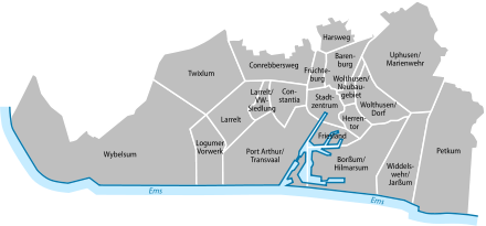
Emden districts
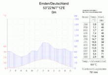
Emden climate diagram
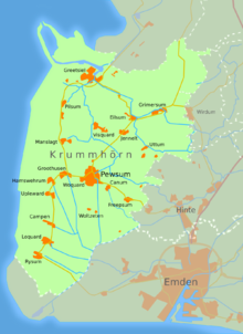
Map of the Emden/Hinte/ Krummhörn region: A dense network of waterways runs through the region.
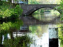
Old ditch
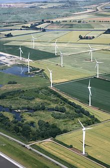
Fertile limestone marsh: farmland in the Wybelsumer Polder
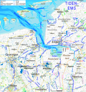
Emden at the mouth of the Ems: Mudflats in pale, areas below chart zero in bright blues; waters shielded from tides muted blue
Politics
City Council Election 2016
Voter turnout: 49.0
%
40
30
20
10
0
31,0
20,2
19,1
12,1
11,3
5,3
0,9
SPD
GfE
CDU
FDP
Green
Left
Otherwise.
gains and losses
compared to 2011
%p
25
20
15
10
5
0
-5
-10
-15
-20
-25
−20,8
+20,2
−1,9
+3,7
−4,1
+2,1
+0,9
SPD
GfE
CDU
FDP
Green
Left
Otherwise.
Template:Ballot Chart/Maintenance/TITLE too long
city council
The City Council consists of 42 councillors. In addition, the Lord Mayor is a voting member by virtue of office. The city of Emden was an SPD stronghold for decades until 2016.
The Lord Mayor of the city since the local elections in September 2011 was Bernd Bornemann (SPD). He replaced Alwin Brinkmann, who had held this office since 1986 - initially on an honorary basis and since 1998 on a full-time basis, making him the longest-serving Lord Mayor in Lower Saxony since September 2006. Tim Kruithoff has been Lord Mayor of Emden since 1 November 2019.
From the end of the Second World War until the municipal elections in 2001, the SPD - with the exception of a short period in the 1950s - always had an absolute majority of votes in the elections to the city council. This majority was sometimes more than 60% of the valid votes cast. The municipal election of 2001 could therefore be seen as a caesura in municipal politics, since the Emder SPD received "only" 39.5 % of the votes. At the same time, the Emder FDP achieved one of the best election results of the party in the whole of Germany with just under 24.3 %. In the local elections in September 2006, however, the Social Democrats regained the majority. The FDP lost significantly in that election, but the result was still above the party's national average in the election. Conversely, the Christian Democrats performed well below the state average.
The official final result of the municipal election on 11 September 2011 (with comparative figures for the municipal election of 10 September 2006):
| 2011Party | pro rata votes | Change from | Seats | Change from |
| SPD | 51,8 % | - − 2,7 | 22 seats | - − 1 |
| CDU | 21,0 % | + 1,9 | 9 seats | + 1 |
| FDP | 8,4 % | - − 6,4 | 4 seats | - − 2 |
| Bündnis 90/The | 15,4 % | + 7,8 | 6 seats | + 3 |
| The Left | 3,2 % | - − 0,6 | 1 seat | - − 1 |
There were drastic changes in the composition of the city council as a result of the 2016 local elections, with the SPD losing 20.8% of the votes and the first-time voters' association "Gemeinsam für Emden" (Together for Emden) GfE gaining 20.2% of the votes from a standing start.
The official final result of the municipal election on 11 September 2016 (with comparative figures for the municipal election of 11 September 2011):
| 2016Party | pro rata votes | Change to | Seats | Change to |
| SPD | 31,0 % | - − 20,8 | 13 seats | - − 9 |
| GfE Voters' Association | 20,2 % | + 20,2 | 9 seats | + 9 |
| CDU | 19,1 % | - − 1,9 | 8 seats | - − 1 |
| FDP | 12,1 % | + 3,7 | 5 seats | + 1 |
| Bündnis 90/The | 11,3 % | - − 4,1 | 5 seats | - − 1 |
| The Left | 5,3 % | + 2,1 | 2 seats | + 1 |
See also: Results of the local elections in Emden
Mayor
→ Main article: List of mayors of Emden
Since 1877 the official title in Emden has been Lord Mayor.
In the penultimate mayoral election on 11 September 2011, Bernd Bornemann (SPD) was elected full-time Lord Mayor. He achieved 61.2 % of the votes and was thus ahead of the non-party candidate Martin Lutz, who was supported by the CDU and FDP, with 38.8 %. The voter turnout was 45.8 %.
After Bornemann did not run in the last mayoral election on September 8, 2019, Tim Kruithoff, who is not affiliated with any political party, prevailed with 75.4% of the vote in the first round. He took office on 1 November 2019, ending an era of SPD mayors that had lasted uninterrupted for over six decades, with candidate Manfred Eertmoed receiving only 16.4%. 6 other non-party candidates did not get more than 3% each.
Representatives in the Landtag and Bundestag
The city belongs to the state parliament constituency of Emden/Norden, which consists of the city of Emden, the city of Norden and the municipalities of Krummhörn, Hinte and Hage. Two members of parliament from the constituency are represented in the Lower Saxony state parliament (election period from 2017). Directly elected MP is Matthias Arends (SPD). Via the state list Hillgriet Eilers (FDP) also entered the Lower Saxony state parliament. The second vote result of the SPD of 49.4 percent was again the best of this party in the 87 constituencies of Lower Saxony.
In federal elections, Emden belongs to the electoral district 24 Aurich - Emden. This includes the city of Emden and the district of Aurich. In the 2017 Bundestag election, the Social Democrat Johann Saathoff was elected directly. Via list positions of the parties, no candidate of the parties from the constituency moved into the Bundestag. The people of Emden voted with an absolute majority for Saathoff in the first votes and with a majority for the SPD in the second votes. Since 1949, Emden has been represented in the Bundestag by directly elected SPD representatives only.
Coat of arms
The Emden coat of arms was granted to the city in 1495 by King Maximilian I after long petitioning and payment of high fees. The coat of arms bears the name "Engelke up de Muer" ("Little angel on the wall") and is in the city colours (gold, red, blue).
|
| Blazon: "Above blue waves a red battlement wall; above it growing in black a golden crowned virgin eagle." |
| Coat of arms reason: The blue waves symbolize Emden's connection and proximity to the Ems, which at that time still flowed directly past the city. The wall in the middle stands for the security and protection Emden offered, as well as for the Ems wall, which separated Emden from the Ems. The golden angel is based on the former coat of arms of the Cirksena family, the ruling noble family of the town at that time. This is not a "real" angel, but a harpy, a female demon of mischief with wings and claws from Greek mythology, also known in heraldry as the "virgin eagle". |
The town's motto, which is also carved in stone above the entrance to the town hall, reads in Latin "Concordia res parvae crescunt." (Through concord small things grow. )
Twinning
Emden is twinned with the following cities:
- Arkhangelsk, Russia, since 1989
- Haugesund, Norway, since 2009
From 1990 to 2008 there was also a partnership with Prenzlau in Brandenburg. This mainly served to help with the reorganisation of local government in the town after the fall of the Berlin Wall and has since been dissolved by mutual agreement. Until January 2012, Emden had a partnership with London Borough of Hillingdon in England, which had existed since 1961. However, as the contacts were hardly maintained lately, the London Borough dissolved the partnership.
With Arkhangelsk, on the other hand, there is a lively exchange, especially at the scientific level with the university there. In addition, several members of the Council have suggested twinning with a Chinese port city with a university of applied sciences.
Ship sponsorships
Emden was the official sponsor city of a total of five ships of German navies, most recently the frigate of the same name, which was commissioned in 1983 and decommissioned in 2013; it was also the first ship to be built in Emden: at the Nordseewerke.
See also: list of ships named Emden
.jpg)
Emden's sponsor ship: the frigate Emden during an exercise in the North Atlantic
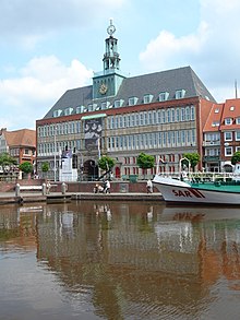
City Hall
Search within the encyclopedia
