Eilenburg
![]()
The title of this article is ambiguous. For other meanings, see Eilenburg (disambiguation).
The large district town of Eilenburg is a town on the Mulde River in the northwest of Saxony on the edge of the Dübener Heide, about 20 kilometers northeast of the university and trade fair city of Leipzig. The town belongs to the administrative district of Nordsachsen and has just under 16,000 inhabitants, making it the fourth largest town in the district. It is a medium-sized centre and belongs in the broader sense to the Leipzig-Halle conurbation, which is part of the metropolitan region of Central Germany. Eilenburg is well integrated into the road and rail network of Saxony and Central Germany with two federal highways and several railway lines.
In 961 the "civitas Ilburg" was mentioned for the first time in a document of Otto I. With Frederick I of Wettin, the Wettins began their rule over the town and the country. Eilenburg Castle is regarded as the cradle of Saxony, since the Saxon territorial state was founded with the enfeoffment of Henry I of Eilenburg with the Mark of Meissen in 1089. Under the protection of the castle, which was built on a high plateau, a planned town complex was established on the Via Regia around 1200. In 1639, during the Thirty Years' War, the town was threatened with complete destruction by the Swedes, which was prevented by Martin Rinckart's supplication. The Peace of Eilenburg finally ended the war for Saxony in September 1648. In 1813 Napoleon I took up quarters in Eilenburg and held the last military review of his allied Saxon troops there before the Battle of Leipzig. Eilenburg, ceded to Prussia by the terms of the Congress of Vienna, developed into an important industrial centre in the 19th century. The population explosion and the resulting severe social tensions promoted the Eilenburgers' response to the social question. For example, the factory owner Carl Degenkolb introduced the first works councils in Germany in his factory. The doctor Anton Bernhardi and his comrades-in-arms founded the first consumer cooperative, the Lebensmittelassociation, in 1849 and the first real credit cooperative in Germany, the Eilenburger Darlehnskassenverein, a year later.
During the Allied bombardment in World War II, about 90 percent of the city was destroyed. After the years of reconstruction, development in the city stagnated. The shortage and environmental pollution caused by the industry also prompted the citizens of Eilenburg to peaceful demonstrations in autumn 1989. After the reunification the grown industrial structure disintegrated. Heavy migration and a low birth rate put the town into a process of shrinkage that continues to this day. At the same time, the decline of industry allowed soft tourism to develop. The town, marketed as a "Mulde town with a green heart", is now a station on national and international tourist routes.
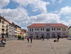
Marketplace
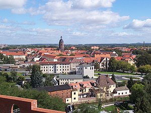
City center of Eilenburg seen from the castle hill
Geography
Geographical position
Eilenburg is located in the Mulde river valley south of the Dübener Heide on the eastern edge of the Leipzig lowland bay. The Mulde flows through the town and separates the district East from the rest of the town. North and south of the city it flows as a wild river with many meanders through a wide floodplain. In addition, the Lossa, coming from the Hohburger mountains, flows into the Mulde in Eilenburg. As a result, Eilenburg was severely affected by the flood of the century in August 2002, when the entire town centre was flooded.
The nearest larger cities are Leipzig (20 kilometres away) and Taucha (15) in the southwest, Delitzsch (21) in the west, Bad Düben (16) in the north, Torgau (27) in the east and Wurzen (12) in the south.
The market place as the centre of the town lies at an altitude of 106 metres above sea level. The highest elevations in the immediate vicinity are the Steinberg (155 metres) south of Pressen and the Philipsberg (133), the Golmesberg (158) and the Heidenberg (159) southwest of Wedelwitz.
Six communities border on the city of Eilenburg: in the north Zschepplin, in the northeast and east Doberschütz, which is already part of the nature park Dübener Heide, in the southeast Thallwitz in the district of Leipzig, in the southwest Jesewitz, in the west Krostitz and in the northwest Schönwölkau in the area of the Kämmereiforst.
Geology
The landscape around Eilenburg is shaped by glacial end moraines of the Saale ice age. West to southwest of Eilenburg begins the landscape conservation area Taucha-Eilenburg end moraine landscape with a size of 38.1 square kilometers. Several times inland glaciers advanced into the area of North Saxony and left behind mighty gravel covers. These were partly carried along again by the meltwater, but in the cold phases they were again gravelled up by loose rock material from the low mountain ranges. The gravels and sands deposited at that time are now quarried east of Eilenburg, creating new lakes there. The western part of Eilenburg lies on a layer of Holocene loams and gravels.
City breakdown
Districts
Based on the settlement structure and the geographical conditions, the urban area can be divided into the districts Eilenburg-Berg in the west, Eilenburg-Mitte and Eilenburg-Ost, whereby a separate statistical registration of these is not carried out by the city administration. The districts Berg and Mitte are limited by the artificially created Mühlgraben, also areas at the foot of the Burgberg belong to the district Berg, for example the area around the Ilburg Stadium and around the Maxim-Gorki-Platz. The so-called Mühlinsel (mill island), with a population of about 50, which is created by a division of the Mühlgraben on the border between the districts of Mitte and Berg, is usually counted as part of Mitte. The Mulde river borders the districts Mitte and Ost. The Ost district alone provided housing for about 10,000 people, which was about half of the city's population. Since the early 1990s, this district, with its extensive GDR old and new quarters, has suffered from a sharp decline in population and the associated demolition of housing. In contrast, the Mitte and Berg districts have become more attractive through the redevelopment of old buildings and the designation of new residential areas for owner-occupied housing and have a largely stable population.
Historic suburbs of Eilenburg were the Acht Gemeinden, most of which, except for Hainichen, were incorporated in the 19th century. They have the following names: Torgauer Steinweg, Gassen-Gemeinde, Hinterstadt, Sand-Gemeinde, Zscheppelende, Leipziger Steinweg, Hainichen and Tal-Gemeinde.
Local parts
Since 1 January 1974, the village of Hainichen, a few kilometres north of the Berg district with its current population of about 250, has belonged to Eilenburg. Like the town, the village lies on the Mulde. Also on 1 January 1974, the village of Wedelwitz, with just under 200 inhabitants, became part of the town. It is located at the intersection of the B 87 and the B 107 south of Eilenburg-Berg, surrounded by a water protection area.
Since 1997, the municipal area has extended several kilometres further west, where the four villages of the municipality of Kospa-Pressen were incorporated. The westernmost district of Eilenburg is now Behlitz with a little less than 200 inhabitants. Further to the east follows the district Pressen (216 inhabitants), which is connected to the railway line Halle (Saale) - Eilenburg by the station Kämmereiforst. Further towards the city centre follows the smallest district Zschettgau with 173 inhabitants, where the meeting centre Lebens(T)raum is located. In addition to its importance as a cultural centre, it also serves as a meeting place for the local council. Zschettgau is the only part of the village that is not exclusively built on in a village way. There is a small old housing estate here, which was built for the employees of the former LPG. The largest district of Eilenburg, Kospa, with 250 inhabitants, is located on the state road 4.
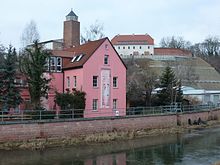
Mühlgraben and Burgberg in Eilenburg
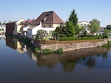
Mühlinsel on the border of the districts Mitte and Berg
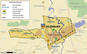
General map of Eilenburg
History
→ Main article: History of the town of Eilenburg
Origin of the city name
Like most place names in the region, the name Eilenburg is of Slavic origin. It is derived from the castle Eilenburg, which was first mentioned in 961 as Ilburg. After this castle the Eulenburg (noble family) carry their name of origin. In the course of the centuries it was handed down many times modified (Hilburg, Ilburg, Hilburch, Ilburc, Ileborch, Ylenburg, Jilburg, Yllenburck, Eylburg, Eylenburg, Eylenberg, Eyleburg, Illeburg, Eilenburgk, Eulenburg, Eulenburgk) and thus experienced also different interpretations. It is most likely that Ilburg can be traced back to the Slavic term il as a place with clay or loam deposits (Jilow, Jilobor). The field adjoining the castle was once called Ilenfeld, and the steep hillside is still called Lehmberg today. Through phonetic change Ilburg became the present name of the village.
City history
prehistory and early history
The oldest human remains in the present-day town of Eilenburg date back to the Palaeolithic Age. Of supra-regional importance in prehistoric and early historical research are the sites from the Magdalenian period in neighbouring Groitzsch near Eilenburg, around 4 kilometres south of the town, from which, among other things, a small clay slate slab with horse depictions engraved on both sides was found. Beginning with the Linear Pottery Culture, the high terraces of the Mulde were among the preferred settlement areas in Central Germany for several millennia. It was not until the Roman Empire and the Migration Period that settlement ceased for a longer period.
Medieval
In the areas between the rivers Saale and Elbe with a residual population of mostly Germanic tribes, which became largely vacant during the Migration Period, Slavic population groups settled from the late 6th century onwards, initially along the Elbe, and in the course of the 7th and 8th centuries also along the Mulde. Eilenburg was situated in the centre of a naturally limited settlement area of about 270 square kilometres on the middle Mulde, in which about 100 smaller hamlet-like settlements developed. Its inhabitants probably called themselves Siusli. The Slavs between the Saale and Mulde rivers belonged to the Sorbs (lat. sorabi sclavi) tribe at the end of the 8th century at the latest. Presumably in the 9th century they built Eilenburg Castle, a ring-like fortress as a refuge on a hilltop-like edge of the Mulde valley, which encompassed a plateau about 220 by 150 metres in size. Remnants of this fortification can be seen in the up to ten-metre-high earthen ramparts on the castle hill. With the incorporation of the areas between the Saale and the Elbe into the East Franconian Empire under the kings Henry I and Otto I, the castle became the centre of a Burgward and thus the centre of a landlordship in the region, which also included a church dedicated to St. Peter.
A civitas Ilburg in the Suisile area is mentioned for the first time in a document of Otto I dated 29 July 961. In the year 1000, the Burgward, which was originally directly subordinate to the king, i.e. the entire area with Eilenburg Castle in the centre, was in the county of Count Friedrich I from the Wettin dynasty. Even after his death, the pagus Siusili and thus also Eilenburg remained in the hands of the Wettins, who held the castle, town and surrounding area until their abdication as kings of Saxony in 1918.
As in other castles in the Mulde region, such as Wurzen or Rochlitz, a merchant's settlement may have developed in front of the castle as early as the 11th century, which formed the root of the later town. In a document issued on April 30, 1161, a parrochia in Ilburch, a parish, is mentioned for the first time. At the end of the 12th and beginning of the 13th century, the castle underwent a representative expansion with a circular wall and at least two towers made of brick. The so-called Sorbenturm (around 1200) and the south-west tower of the castle (after 1230) were residential towers which may have served as the residence of the Burgmannen crew of the important Wettin castle. Also in the decades around 1200, a planned oval town complex 600 metres long and 300 metres wide with a grid-like street network was built on the terrain east of the castle facing the Mulde river.
The town experienced a further rise in the second half of the 14th century under Margrave Wilhelm I.
Modern Times
At the beginning of the 16th century, the incipient Reformation movement reached Eilenburg. Martin Luther stayed in the town a total of seven times and described it as a "blessed lard pit".
The Thirty Years' War also left its mark on Eilenburg. Although the town was initially spared from hostilities, it nevertheless had to accept the catastrophic economic effects of the war. From the year 1631 the town was directly involved in the war. In 1632 the Swedish King Gustav II Adolf was laid to rest in the inn "Zum Roten Hirsch" after he had fallen in the battle of Lützen on 16 November 1632. In 1639 Eilenburg was captured by Georg von Derfflinger's troops. In 1646 further peace negotiations between Saxony and Sweden began in Eilenburg to extend the expiring armistice of Kötzschenbroda until a general peace agreement (Peace of Westphalia) was reached. The Peace of Eilenburg, concluded on September 14, 1648, marked the end of the Thirty Years' War for Electoral Saxony. Subsequently, the city recovered.
The slowly beginning economic improvement was brought to an abrupt end by the Seven Years' War. Almost every man in Eilenburg was called up for military service. The city was alternately occupied by the Austrians and Prussians. With the end of the war Eilenburg was again an impoverished and plundered town. At the end of the 18th century the economy stagnated. Due to the loss of income from road mandates, according to which commercial traffic passed through the town, Eilenburg had become an insignificant country town.
Although the French Revolution provided a slight economic upswing, this was neutralised by the French rule which lasted from 1806 to 1813. During the Coalition Wars, Napoleon took up quarters in Eilenburg in 1813 shortly before the Battle of the Nations near Leipzig and held the last military review of his allied Saxon troops in front of Kültzschau, today's Eilenburg-Ost. After Napoleon's defeat, Eilenburg and the Amt Eilenburg belonged to the area which Saxony had to cede to Prussia according to the provisions of the Congress of Vienna in 1816. Due to the affiliation to the extremely modern state as a result of the Prussian reforms, the transition of Eilenburg from a rural to an industrial town was significantly advanced.
Due to the foundation of numerous textile manufactories in the suburbs, Eilenburg became an important centre of Prussian textile production. The rise to an important industrial town came mainly from nearby Saxony. Saxon industrialists settled in Eilenburg in order to gain duty-free access to the Prussian market. The incipient rural exodus caused the population of Eilenburg to increase by leaps and bounds. The social tensions resulting from industrialisation and the enormous population growth associated with it fostered a strong workers' movement, of which the town became the centre. Thus, in 1849 the Krankenkassenunterstützungsverein was founded, in 1850 the Eilenburger Lebensmittelassociation (Konsumgenossenschaft Sachsen Nord) as the first food cooperative in Germany as well as the Darlehnskassenverein, the first credit cooperative in Germany. The Eilenburg calico printing works owner Carl Degenkolb, a member of the Frankfurt National Assembly, voluntarily set up the first works councils in Germany in his factory.
With the concession document for the Halle-Sorau-Guben railway company, the town received its first railway connection at the end of the 19th century. On 30 June 1872 the Halle-Eilenburg-Falkenberg line was opened, and on 1 November 1874 the Eilenburg-Leipzig line. With the connection to the railway network and the associated access to the brown coal fields, the economy of Eilenburg developed further. Mainly chemical and wood and metal processing industries settled here. With the settlement of the Leipzig company Mey & Co. the later Deutsche Celluloid-Fabrik (German Celluloid Factory), a company settled in the town which shaped the town for over a hundred years. With the piano factory of the Zimmermann brothers, founded in 1904, Eilenburg was the main location of the largest piano manufacturer in Europe.
During the First World War, hundreds of people from Eilenburg were drafted for military service. At the Eilenburg train station on October 21, 1917, the later president of the GDR Wilhelm Pieck is said to have escaped from a military transport. In total, the First World War cost 800 Eilenburgers their lives.
In the early days of the Nazi dictatorship, Eilenburg was a stronghold of the Communist Party of Germany (KPD). Its influence extended so far that there was collusion between members of the SA and communists. This was "an expression of the discontent of disappointed petty-bourgeois Nazi supporters". Later, the Gestapo focused its attention particularly on Eilenburg. About two weeks before the end of World War II, the town was almost completely destroyed. On April 17, 1945, a tank alarm was sounded in Eilenburg, the town was declared a fortress, and defense to the utmost was ordered. For three days and three nights the town was under heavy artillery fire, during which a large part of the town's building fabric was destroyed. Two hundred lives were lost in the senseless defense, 90 percent of the town center (65% of all the town's buildings) was destroyed, while the American units suffered hardly any casualties. Eilenburg was one of the most heavily destroyed cities in Germany.
In 1947, 237 Eilenburg residents returned from captivity. Three years later, Eilenburg was the scene of the first major event after the war. The one hundredth anniversary of the first German consumer cooperative was celebrated in the town. The town centre was rebuilt in the 1950s. With the administrative reform of 1952 in the GDR, the town became the seat of the newly formed district of Eilenburg. Especially in Eilenburg-East some new housing estates were built since the beginning of the 1960s. In the 1970s, the eleven-storey Eilenburg high-rise building was also erected using the then new tunnel formwork method. In 1989, the mood of change was also evident in Eilenburg through peaceful demonstrations in which up to seven thousand people took part.
After reunification, many traditional companies went out of business; the remaining employers also drastically reduced their workforces in some cases. The lost jobs could only be partially compensated by new settlements on newly created industrial areas outside the town, such as Stora Enso. In 1994, the district of Eilenburg was incorporated into the old district of Delitzsch in the course of the district reform and the town lost its district seat. In return, Eilenburg was granted the status of "Große Kreisstadt" (large district town) under municipal law in 1997.
Eilenburg was also badly hit by the flood of the century in the summer of 2002 when the Mulde River flooded. The damage amounted to around 135 million euros in the centre alone. The construction of flood protection facilities, which was intensified after the flood, was officially completed on 19 September 2008 after investments amounting to 35 million euros. Eilenburg is the first completely flood-protected town in Saxony. The flood protection proved its worth during the strong Mulde flood in June 2013.
With the second Saxon district reform after 1990, which came into force on 1 August 2008, Eilenburg belongs to the newly formed district of North Saxony and is one of four district administrative locations.
Religions
In Eilenburg there are exclusively Christian church congregations. These are:
- Protestant parish Martin Rinckart Eilenburg. This includes the mountain church Sankt Marien and the city church Sankt Nikolai.
- Catholic Parish. The place of worship of this parish is the church of Saint Francis Xaverius.
- Evangelical Free Church congregation Eilenburg, since 2006 with a new place of worship, the Friedenskirche.
- New Apostolic Church
- The Church of Jesus Christ of Latter-day Saints
Incorporations
The former town area of Eilenburg only extended from today's Nordring to the Dr.-Külz-Ring and Wallstraße respectively, where the town walls were located. When industrialization began in the middle of the 19th century, the city walls were first torn down and then the Eilenburg suburban communities, where numerous factories had already settled, were incorporated. In 1856 the communities of Torgauer Steinweg, Hinterstadt, Sand-Gemeinde, Leipziger Steinweg, Zscheppelende and Tal-Gemeinde were incorporated. In 1859 Hintersteinweg followed and on August 2, 1864 Kültzschau, the core of today's Eilenburg-Ost. The new districts grew together with the historical town area in a short time. On 1 January 1974 Wedelwitz and Hainichen southwest of Eilenburg were incorporated and on 1 January 1997 the municipality of Kospa-Pressen with four districts.
Population development
→ Main article: Population development of Eilenburg
In 1806, Eilenburg, as a country town, had only slightly more than 2000 inhabitants. The onset of industrialisation and the affiliation to Prussia determined by the Congress of Vienna in 1815 ensured that the number of inhabitants doubled by 1816. The economy continued to grow in the coming decades, so that the number of inhabitants doubled again by 1871. The First World War did not mean a slump in the population of Eilenburg - it grew to over 20,000 during the Weimar Republic and until the outbreak of the Second World War. The influx of refugees and expellees from the eastern territories of the German Reich at the end of the Second World War and the expulsion of Germans from Czechoslovakia caused the population to rise briefly to an estimated 30,000; the devastating destruction of the town in April 1945 caused the number to fall sharply again, and ultimately the town lost 2,000 inhabitants compared to its pre-war level. During the time of the GDR, the city and thus the number of inhabitants grew again. It reached its historic peak in 1986 with just under 22,000 inhabitants.
With the fall of communism and the decline of industry, this development was reversed. Between 1990 and 2008, the population declined by more than twelve percent, with the number of inhabitants decreasing by up to 2.4 percent p.a. in the first years after reunification. From 1999 onwards, a slight weakening of the shrinkage can be observed - the reduction was up to 1.3 percent p.a., whereby in 2002, due to the severe Mulde flood, a rash of departures was recorded. The decline in the number of inhabitants is due, on the one hand, to the difference between births and deaths. Since 1990, the number of births has been significantly lower than the number of deaths each year; on average, there have been about 100 more deaths than births each year. On the other hand, there is an evident discrepancy between in-migration and out-migration; especially in the years 1991, 1995, 1996, 2002 and 2010 there was a strong out-migration. Only in 1992, 1993, 2003, 2012 and 2013 did in-migration outweigh out-migration.
Although the birth rate increased noticeably in 2007, so that in that year there were the most births per thousand inhabitants since 1990 and the most total births since 1995, a trend reversal in the population development is not in sight. Since 2012, the population figures have been rising again.
Population forecast
Due to the generally weaker economic structure in the new federal states, Eilenburg is more affected by demographic change than comparable municipalities in western Germany. According to the Bertelsmann Stiftung's Guide to Demographic Change 2025, the town belongs to the category of towns and municipalities - category 4. This category includes towns with a sharply declining population and an ageing society. Both result from an exodus of the young population - especially those with higher educational qualifications - and low birth rates. Other characteristics for this category are high unemployment and low economic potential.
In 2025, the forecast for Eilenburg indicates a population of just over 15,000 people. This is a minus of about 25 percent compared to 1990, and a minus of 12.4 percent compared to 2006. Eilenburg is expected to lose more than 2000 inhabitants between 2006 and 2025. The average age will then be 50.5 years, the proportion of the 0 to 18 year olds will be exactly 14 percent, that of the over 80 year olds about 11 percent. The largest proportion of the population will then be in the 45-64 age group.
Eilenburg launched a campaign in 2016 to benefit from Leipzig's population growth: "Lieblingsstadt Eilenburg - Das Beste an Leipzig" (Eilenburg's favourite city - the best of Leipzig) particularly emphasises the rapid accessibility of the big city by S-Bahn.
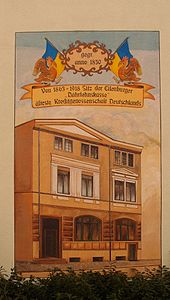
Wall painting at Nikolaiplatz: Eilenburger Darlehenskasse, the oldest credit cooperative in Germany, founded in 1850
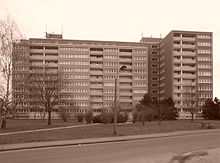
High-rise building in Eilenburg-East
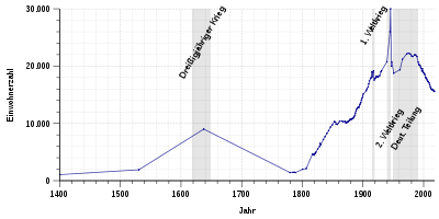
Population development of Eilenburg from 1400 to 2017
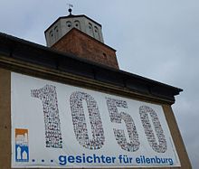
1050th anniversary of the castle
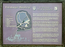
Information board on the castle hill

Town view of Eilenburg around 1650 by Matthäus Merian

Plaque at the former inn Zur Rose: "Here the Food Association of Eilenburg was founded on 12.7.1850 as the first consumer cooperative in Germany".
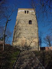
Late Romanesque residential tower made of brick, the so-called Sorbs' Tower (around 1200)
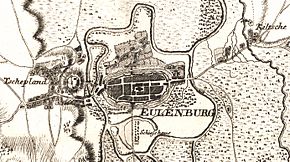
Eilenburg in a cabinet map around 1762 by Isaak Jacob von Petri, at that time still called Eulenburg
Search within the encyclopedia