Alsace: geography, history, culture and modern administration
Alsace is a historic region on France's eastern border with Germany and Switzerland, noted for its Germanic culture, wines, Strasbourg, and a history of shifting sovereignty; now part of the Grand Est region.
Alsace is a historic territory on the eastern edge of France, lying at the western bank of the Upper Rhine. Traditionally composed of the departments Bas-Rhin and Haut-Rhin, its largest city and historic capital is Strasbourg. The area is known for a distinctive blend of French and Germanic influences in language, architecture, culinary traditions and social customs.
Image gallery
10 Images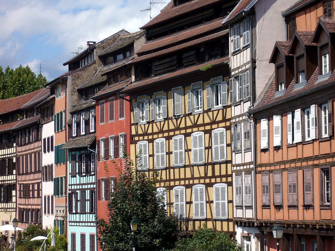


Geography and landscape
The region stretches from the Rhine river in the east to the Vosges mountains in the west. This contrast of river plains and low mountain ranges has shaped settlement patterns, agricultural practices and transportation routes. Vineyards run along the slopes of the Vosges, producing the aromatic white wines for which Alsace is famous. The Rhine valley also creates important ecological corridors and has long been a major north–south transit axis in western Europe.
Historical outline
Alsace has a long, layered history. In the medieval era it formed part of the Holy Roman Empire and was inhabited by Germanic-speaking communities. From the 17th century the region came under French sovereignty, notably during the reign of Louis XIV. In the modern era Alsace became a focal point of Franco‑German rivalry: it was contested and changed hands during the 19th and 20th centuries and was often paired administratively with neighbouring Lorraine as Alsace‑Lorraine. These shifts influenced law, administration and local identity.
Language, culture and daily life
The local vernacular, Alsatian, belongs to the Alemannic group of Upper German dialects. While standard French is the language of administration and public life, Alsatian dialects survive especially in rural communities and in family contexts. Cultural expressions—folk music, costumes, festivals and traditional cuisine such as choucroute (sauerkraut) and tarte flambée—reflect a mix of Germanic and French elements. Strasbourg’s renowned Christmas markets and half‑timbered houses are emblematic of regional identity.
Economy and institutions
Agriculture (notably vineyards), light industry and services are important to the regional economy. Strasbourg is an administrative and commercial hub and hosts several international and European institutions, which gives the city and surrounding area an important institutional role beyond the local economy. Tourism, driven by cultural heritage, gastronomy and wine routes, remains a durable source of income.
Modern administration and notable facts
As part of a national territorial reform in the 2010s, Alsace was merged administratively into the larger Grand Est region; however, the two departments—Bas‑Rhin and Haut‑Rhin—remain fundamental administrative units and local identities continue to be strong. Population totals have been around the low millions in recent decades, concentrated in urban areas such as Strasbourg and Mulhouse. The region is often cited as an example of cultural hybridity in Europe, where borderland history has produced a rich, layered identity.
Further links and references
- Alsatian language
- Alemannic German
- Historical German name Elsaß
- Former administrative region of France
- Grand Est region
- Border with Germany
- Border with Switzerland
- Bas-Rhin department
- Haut-Rhin department
- Champagne-Ardenne
- Lorraine
- Regional reform (2014 law)
- INSEE population data
- Regional capital (Strasbourg)
- Strasbourg city
- Largest city in the region
- Holy Roman Empire
- 17th century annexations
- Treaty of Verdun
- Charlemagne and early medieval divisions
names
The name Elsass refers to a landscape and political entity already attested in the early Middle Ages. Early Latinized mentions are in pago alsacense (772) and in pago alisacense (774), pure German the name appears as elisazon for the first time in a document of 877. It derives from early High German ali-sāzzo "inhabitant of the other (to add:) Rhine bank" or, elliptically shortened, from early High German ali-land-sāzzo "inhabitant in a foreign country" and is thus a composition of Old High German ali-, eli- "other, foreign", at best land "country" as well as sāzzo "sitter, dweller". Among the "inhabitants of the foreign land", one is most likely to think of the new Frankish settlers who, after the Battle of Zülpich in 496, were settled by the Frankish monarchy on the left bank of the Rhine between Basel and the Palatinate, where they encountered Romans and Alemanni.
Due to the changeable history of Alsace between the Germanic (German) and Romance (French) cultural area, designations based on this arose. Since Alsace was German-speaking and it is still partly today, Welschi or Walschi stands or stood in Alsace for Innerfranzosen in general as well as for the Romansh (Lorraine/French) language enclaves on the eastern side of the Vosges (pays welche) in particular and their language. The Alsatians are also colloquially and pejoratively referred to as Wackes by the German-speaking neighbouring regions, which in Alsatian dialect initially meant country people or unemployed people and partly corresponds to the reverse term Boche.
Geography
Alsace borders Germany (Rhineland-Palatinate to the north, Baden-Württemberg to the east) and Switzerland (cantons of Basel-Stadt, Basel-Landschaft, Solothurn and Jura). To the west, Alsace borders Lorraine, and to the south the Bourgogne-Franche-Comté region.
Today's Alsace has a north-south extension of 190 kilometres, while the west-east extension is only 50 kilometres. In the east, Alsace is bordered by the Rhine, in the west over long stretches by the main ridge of the Vosges. In the north, the Bienwald and Pfälzerwald mark important border areas, in the south the northern edge of the Jura and in the southwest, in the open gateway landscape of the Burgundian Gate, the border, which dates back to 1871, approaches the watershed between the Rhone and Rhine.
The geological history extends from the Precambrian to the Quaternary.
Alsace has the following main natural units:
- Most of it is occupied by the Alsatian Plain (Plaine d'Alsace), which forms the southern part of the Upper Rhine Graben with Breisgau and Ortenau on the German side, and the Petit and Grand Ried on the Alsatian side. It is crossed by the Ill River and is dominated by cereal farming. There are also large forest areas such as the Hagenauer Forst in the north and the Harthwald in the south. In addition to wide plains, undulating to hilly areas occur (for example Kochersberg northwest of Strasbourg, western Sundgau and eastern Burgundian Gate, area between Hagenau Forest and Bienwald).
- To the west, the landscape is dominated by the Vosges, criss-crossed by the wide valleys of the Ill tributaries. Here you will find high pastures (Hautes Chaumes) alternating with forests. The Große Belchen (Grand Ballon) is the highest peak in Alsace and the Vosges, at 1424 m. In France, the areas north of the Zabern Valley are also counted as part of the Vosges (Vosges du Nord), but they form a natural unit with the Palatinate Forest.
- A narrow foothill zone mediates between the plain and the Vosges (analogous to the western edge of the Black Forest). Wine growing is typical for this "Piedmont of the Vosges".
- In the very south, Alsace also has a share of the Jura (Pfirter Jura).


Questions and answers
Q: What is Alsace?
A: Alsace was an administrative region of France that is now part of the Grand Est region. It was located on the eastern border of France, next to Germany and Switzerland.
Q: How many people lived in Alsace before it merged with Champagne-Ardenne and Lorraine in 2014?
A: According to INSEE data, about 1.8 million people lived in Alsace as of 2013.
Q: What were the two departments that made up Alsace?
A: The two departments that made up Alsace were Bas-Rhin and Haut-Rhin.
Q: What city served as the capital for Alsace?
A: Strasbourg was the capital city for Alsace. It was also the largest city in the region.
Q: How did control over Alsace change between France and Germany over time?
A: Control over Alsace changed multiple times between France and Germany throughout history.
Q: How did culture differ between French and German influences in Alsace?
A: The culture in Alsatian differed from French culture due to its closer proximity to Germanic influences such as language, cuisine, music, dress, customs, etc., which were more similar to those found across the Rhine River in Swabia than those found within France itself.
Q: When did Louis XIV annex all of Alsace into one province of France? A: King Louis XIV annexed all of Alsatian into one province of France during the 17th century.
Related articles
Author
AlegsaOnline.com Alsace: geography, history, culture and modern administration Leandro Alegsa
URL: https://en.alegsaonline.com/art/3003
Sources
- insee.fr : "Populations légales 2013 des régions"