Dornbirn — largest city of Vorarlberg, Austria
Dornbirn is the largest town in the Austrian state of Vorarlberg. A regional economic, cultural and educational center, it blends a textile-industrial heritage with contemporary services, fairs and mountain recreation.
Dornbirn is the largest city in the Austrian state of Vorarlberg and an important local center in western Austria. Its population has been roughly around 48,000–50,000 residents in recent decades. Located in the Rhine Valley, Dornbirn functions as a commercial, educational and cultural hub for the surrounding alpine and lake regions.
Image gallery
10 Images


Geography and setting
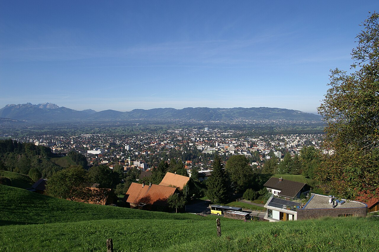
The city sits at the foot of the Karren and other low mountains, offering quick access to hiking and viewpoints as well as to nearby Lake Constance and international borders with Switzerland and Germany. Its position in the broad Vorarlberg valley has shaped transportation links, commuting patterns and the distribution of industry.
History and development
Dornbirn grew from a market town into an industrial center during the 19th century, when textile manufacturing and weaving became dominant local industries. Over the 20th and 21st centuries the economy diversified, and many former factory sites have been repurposed for services, trade fairs and education while elements of the historic townscape remain visible.
Economy, institutions and culture
Today Dornbirn hosts trade fairs and business events, most notably at its exhibition center, and contains regional offices, small and medium enterprises, and research or teaching institutions such as the local campus of the University of Applied Sciences. Museums and discovery centers, including a popular natural history and science center, complement cultural programming that ranges from music and theatre to public festivals.
Districts and local organization
The municipality is divided into six principal districts, each with its own character and functions. These are:
- Markt — the historic and commercial core
- Hatlerdorf — residential and mixed-use areas
- Oberdorf — older residential quarter
- Haselstauden — suburban neighborhood with local shops
- Rohrbach — residential and industrial sections
- Schoren — quieter outskirts with green spaces
Visitors and residents often use the Karren cable car for panoramic views and outdoor recreation. Dornbirn's blend of industrial heritage, modern services and alpine access makes it representative of the broader economic and cultural patterns of Vorarlberg.
Geography
Geographical location
Dornbirn lies at an altitude of 437 metres in the Rhine Valley at the foot of the Bregenzerwald Mountains and thus on the western edge of the Eastern Alps. Geographically, Dornbirn belongs to the landscape Vorderer Bregenzerwald, which is part of the Austrian Pre-Alps. By far the most important river is the Dornbirner Ach, which divides the town area into two halves and thus also forms the border of some town districts.
Geology
The largest part of the Dornbirn settlement area lies directly on the sedimentary fan of the Dornbirner Ach. Due to its location in the Rhine valley, the municipality is geologically situated in the so-called Lake Constance basin, which was partly formed tectonically, but on the other hand was formed by erosion of the Rhine glacier, which receded after the last ice age. The Lake Constance basin forms the subsoil on which the sediments washed ashore by the Dornbirner Ach could be deposited and thus determine the subsoil of Dornbirn today. To the east of the municipal area rise the first mountains of the Eastern Alps, which here for the most part still consist of friable diluvial masses.
Sea level
The general sea level of the town of Dornbirn is given as 437 m above sea level. This corresponds to the location of the stone town coat of arms, which is embedded in the middle of the market square. The geographically lowest point of Dornbirn is the riverbed of the Dornbirner Ach a few meters before the confluence of the Vorarlberger Rheintal-Binnenkanal in the far north of the municipality at 399 m a.s.l. The highest point is the summit of the Sünser Spitze at 2061 m a.s.l.
City breakdown
| Municipalities of Dornbirn | |||
| # | District | Inhabitants | Location |
| 1. | Market | 13.706 | Middle |
| 2. | Hatlerdorf | 11.161 | South |
| 3. | Upper Village | 05.000 | East |
| 4. | Hazel Perennials | 05.409 | North |
| 5. | Rohrbach | 07.755 | West |
| 6. | Shores | 05.638 | West |
| Inhabitants as of 2012 | |||
Dornbirn did not grow together from formerly independent villages, but was always a single municipality, whose settlement areas, however, were very scattered and consisted of four non-contiguous parts with today's districts 1 to 4. At that time these "quarters" were called Niederdorf, Hatlerdorf, Oberdorf and Stiglingen. It was not until 1902 that these four districts were officially declared city districts with their present names (Niederdorf became the district Markt, Stiglingen became Haselstauden). Today there is an urban area that has grown together, which has also expanded considerably west of the railway line, especially in the second half of the 20th century. In these areas, the districts of Rohrbach and Schoren were partly formed, which only became separate city districts in 1994.
Local parts
The population of the town is mainly concentrated in the core area in the far northwest of the municipality. However, especially on the mountain slopes to the east of the town, there are still numerous smaller villages known as mountain parcels. These include Watzenegg and Kehlegg, which have high land prices, especially because of their hillside location and views of the Rhine Valley. In addition, Winsau, Heilgereuthe and numerous other clusters of houses in the eastern mountain area also belong to the town of Dornbirn. The most outstanding parcel of land in Dornbirn is the Walser village of Ebnit, which was formerly an independent municipality and became part of the town in 1932 due to financial problems. Ebnit is also the southernmost and easternmost year-round inhabited area of Dornbirn and thus forms the centre of the south-eastern municipal area, which is characterised by mountains and forests.
Neighboring communities
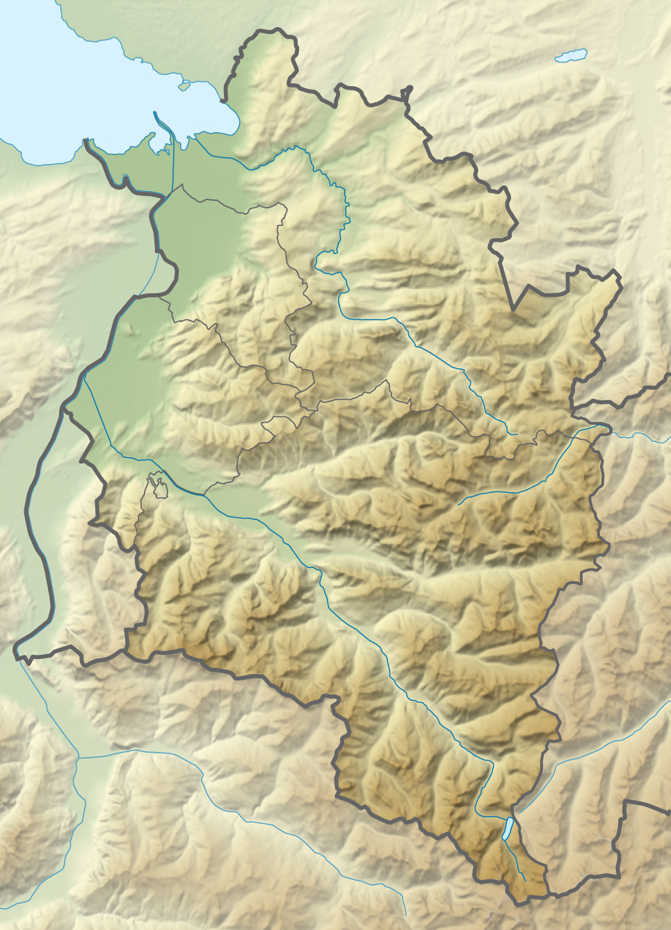
Due to the size of Dornbirn's municipal area, the town has numerous borders with other municipalities. Of Dornbirn's 15 neighbouring municipalities, nine belong to the political district of Bregenz (Lauterach, Wolfurt, Schwarzach, Bildstein, Alberschwende, Schwarzenberg, Reuthe, Mellau and Damüls) and four to the district of Feldkirch (Laterns, Zwischenwasser, Viktorsberg and Fraxern). In addition, the other two municipalities of the district of Dornbirn (Hohenems and Lustenau) border on the municipal area of the town, which is the only municipality in the district that does not have a state border as a municipal boundary. (Municipalities are listed clockwise, starting in the north).
Surface balance
The entire municipal area of Dornbirn covers an area of around 121 square kilometres (12,093 hectares), divided into three cadastral communities
- Dornbirn (9,930.41 ha)
- Ebnit I (1,159.09 ha)
- Ebnit II (1,003.50 ha)
Of this total area, about 4,815 hectares are forest areas and 5,723 hectares are meadows, pastures and alps. The municipal area of the town of Dornbirn accounts for about 70 % of the area of the district of Dornbirn (172.36 square kilometres). Dornbirn is thus the third largest municipality in Vorarlberg in terms of area after Gaschurn and St. Gallenkirch and accounts for 4.65 % of the total area of the province.
Mountain landscape
Due to its location on the edge of the Eastern Alps and the Bregenzerwald Mountains, the town of Dornbirn can name several mountain peaks over 1,500 or 2,000 metres above sea level in its municipal area. The most prominent are the 971 meter high Karren, which is accessible by a cable car and is considered Dornbirn's local mountain, and the Staufen (1465 m above sea level). Also popular with hikers are the 1,830-meter-high Mörzelspitze and the Hohe Freschen, which is 2,004 meters high. The highest mountain in the municipality is the rather inconspicuous Sünser Spitze at 2062 m above sea level. Most of the mountain peaks in the municipality can be reached by hiking trails. Dornbirn's mountain image is determined by the so-called First, the mountain range that includes, among others, the Mörzelspitze, the Hohe Freschen as well as the Sünser Spitze and which can still be seen from Friedrichshafen on clear days.
Rivers and waters
The water map of the municipal area is dominated by the Dornbirner Ach, the main river of Dornbirn. The Ach is one of the most important drainage rivers in the anterior Bregenzerwald and is also the outflow for numerous larger and smaller streams in the Dornbirn mountain landscape. The countless rivers and streams that join the Dornbirner Ach during its course from the southernmost to the northernmost point of the municipal area mostly have no name. The Fallbach is the only stream that does not flow directly into the Dornbirner Ach, but first flows into the Rhine Valley Inland Canal. Lakes are few in Dornbirn, two of the best known being the Sünser See and the Staufensee reservoir. In its course, the Dornbirner Ach also flows through the Alploch and Rappenloch gorges, two millennia-old gorges that are now developed and accessible for tourists.
Climate
The climate in Dornbirn is relatively mild by Austrian standards, favoured by its location in the Rhine valley and the foehn. The average temperature throughout the year is 10 °C.
The warmest month is July with an average of 19.3 °C, the coldest is January with 0.4 °C. Periods of permafrost occur almost annually, but extreme lows are rare. The average lowest temperature in the course of the year is -13.0 °C. Dornbirn, like the entire Alpine Rhine Valley, lies on the border of USDA climate zone 7b to 8a and is one of the regions in Austria with the mildest winters.
The last frost (measurement period 1993-2019) occurs on average on 14 April, the first on 6 November. The average frost-free period is therefore 205 days. Between the beginning of May and mid-October, temperatures do not fall below freezing point.
On an annual average, 13 ice days and 82 frost days are recorded. In contrast, there are 52 summer days and 9 heat days.
The lowest recorded temperature since measurements began in 1993 is -17.9 °C, the highest to date is 36.8 °C.
Remarkable is the annual precipitation, which is high by Central European standards, averaging slightly over 1,500 mm over many years and rising to well over 2,000 mm in parts of the municipality. As a result, closed, partly considerable snow covers are registered in all winters.
The sun shines in winter on average between two and four hours a day. This number increases to over seven hours by the summer months of June to August. The average sunshine duration is just under 1,800 hours a year, which is relatively low for conditions in Austrian valleys.
| Dornbirn | ||||||||||||||||||||||||||||||||||||||||||||||||
| Climate diagram | ||||||||||||||||||||||||||||||||||||||||||||||||
| ||||||||||||||||||||||||||||||||||||||||||||||||
| Monthly average temperatures and precipitation for Dornbirn (1993-2018)
Source: Yearbook ZAMG | |||||||||||||||||||||||||||||||||||||||||||||||||||||||||||||||||||||||||||||||||||||||||||||||||||||||||||||||||||||||||||||||||||||||||||||||||||||||||||||||||||||||||||||||||||||||||||||||||||||||||||||||||||||||||||||||||||||||||||||


Population
| Population development
|
Population structure
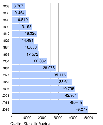
Dornbirn has a current total population of 50,257 people (1 January 2021) - that's about 12% of Vorarlberg's population.
The population of the city is almost equally divided between males and females. While the 2001 census counted 20,730 men (49.0 %), the female part of the population came to 21,571 (51.0 %). In the same census, 86.6% of the inhabitants of Dornbirn were found to hold Austrian citizenship. 74.8% of the inhabitants of Dornbirn (78.03% in Vorarlberg as a whole) professed the Roman Catholic Church, a further 2.6% were of the Protestant faith (2.23% in Vorarlberg), and 2.7% belonged to a Christian Orthodox church (2.61% in Vorarlberg). The second largest faith group was that of Islam. In 2001, 9.9 % of the inhabitants of Dornbirn were Muslims (Vorarlberg 8.36 %), only 8 citizens were of Jewish faith.
The largest age group in this census was the 35-39 year olds with 8.4%. Nevertheless, the average age of the total population in Dornbirn is slightly higher than that of the federal state. 18.5 % (in the whole of Vorarlberg 19.73 %) of the population were under 15 years of age at the time of the survey, 63.3 % (Vorarlberg 63.16 %) were between 15 and 60 years of age, and 18.2 % (Vorarlberg 17.29 %) were over 60 years of age. Some 44.1% of Dornbirn residents were single in 2001, and another 7.0% were divorced. On the other hand, 43.4 % were married and 5.5 % widowed.
Migration and integration
Dornbirn is strongly influenced by immigration: It is the city in Vorarlberg with the highest percentage of foreigners, which is characteristic for the whole district. In 2001, 1.7 % of the people living in Dornbirn were citizens of another EU state and 11.7 % were citizens of a country outside the EU (however, before the EU enlargement to the East).
As in most other cities in Vorarlberg, by far the largest share of the foreign population is of Turkish origin. Thus, 3,484 people stated Turkish as their colloquial language, 4,206 people professed the Muslim faith.
This contrasts with 35,411 people who speak German as their mother tongue and 35,667 people who were born in Austria, as well as 39,812 Austrian citizens (in 2006). This circumstance results from the large waves of immigration in the 1950s and 1960s, when more and more workers were recruited from Turkey as guest workers with the renewed flourishing of the textile industry. Many of these former textile workers now live with their families in Vorarlberg, while younger generations were born in Austria and grew up in Western culture.
On the basis of this, the city of Dornbirn commissioned an intercultural model in autumn 2001, which was presented to the public in November 2002 with the help of the ethnological seminar of the University of Basel and the b.a.s.e. Office for Applied Social Research and Development.
Related articles
Author
AlegsaOnline.com Dornbirn — largest city of Vorarlberg, Austria Leandro Alegsa
URL: https://en.alegsaonline.com/art/28576