Dorah Pass (Durah Pass) — high Hindu Kush crossing between Afghanistan and Pakistan
Dorah Pass links Badakhshan (Afghanistan) and Chitral (Pakistan) across the Hindu Kush. A high, seasonal mountain route notable for its geography, history, and strategic role in 20th-century conflicts.
Overview
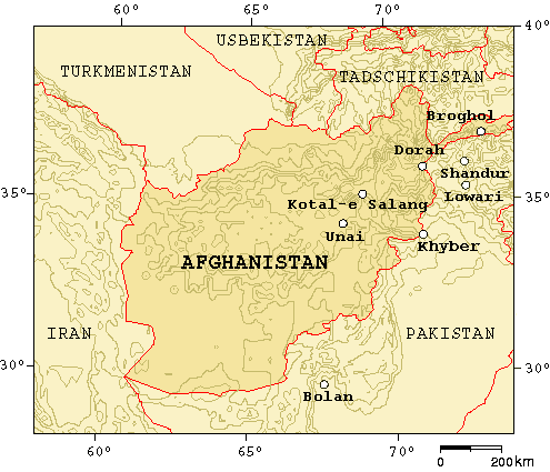
The Dorah Pass, also spelled Durah Pass, is a high mountain crossing in the Hindu Kush that connects Afghanistan's Badakhshan region with the Chitral district of Pakistan. Sitting at an elevation of roughly 4,300 metres (about 14,000 feet), it is one of several rugged routes that link the northern reaches of the Indian subcontinent with Central Asia. The pass lies on a remote frontier where steep slopes, glaciers and narrow valleys shape travel and human settlement.
Image gallery
2 Images
Geography and environment
The Dorah Pass passes through alpine terrain dominated by rocky ridges, seasonal snowfields and sparse high-altitude vegetation. It forms part of the greater Hindu Kush system and is near the wide high plateau often called the Pamir, sometimes described as "the roof of the world." The pass is normally accessible only during a short summer window; winter snows make it hazardous or impassable. Local routes approach from the Afghan side across parts of Badakhshan and on the Pakistani side descend into the valleys of Chitral in Pakistan.
Human use, communities and language
For centuries the pass has been used by small-scale traders, shepherds and seasonal migrants rather than as a major paved highway. Ethnic groups such as the Wakhi, Munji and other Pamiri communities have long maintained transmountain ties on both sides of the frontier. During periods of conflict many civilians have moved across the pass to seek refuge; for example, a significant number of Munji-speaking families crossed into Chitral in the late 20th century to escape violence in Afghanistan.
Historical and strategic importance
Although remote, Dorah assumed greater strategic prominence during the Soviet–Afghan War and subsequent decades because it offered a difficult-to-control corridor for the movement of people, arms and supplies. The terrain limited the effectiveness of conventional surveillance and control, so the pass was one of a handful of passages that shaped military and political dynamics in the region. It is one of the main entrances to Chitral alongside the Broghol Pass, Shandur Top and Lowari Top.
Travel, tourism and access
Today the Dorah Pass attracts a modest number of trekkers and adventurous travelers interested in high-altitude landscapes, cultural encounters and remnant trade routes. Access is subject to seasonal conditions and local regulations; there are no major paved roads or border crossings comparable to lower-altitude international checkpoints. Visitors should plan carefully, travel with experienced guides, and be aware of security and weather risks.
Context and notable facts
- The pass connects regions associated with the larger trans-Himalayan and Central Asian zones, placing it near countries and regions such as Tajikistan, China and Kashmir in broader geographic terms.
- The nearby Pamir area has long been part of historic overland routes; explorers such as Marco Polo are traditionally said to have traversed parts of these highlands on journeys toward East Asia.
- Along with the Chitral approaches from the south and the Afghan valleys from the north, Dorah remains an emblematic high mountain pass where geography, culture and history intersect.
The Dorah Pass continues to be important regionally for its cultural links and strategic location even as modernization changes other crossings. Its remoteness preserves traditional patterns of life while also making it a sensitive frontier feature in a complex geopolitical landscape.
Questions and answers
Q: What is Dorah Pass?
A: Dorah Pass is a high mountain pass that connects Badakshan in Afghanistan with Chitral in Pakistan.
Q: How high is Dorah Pass?
A: Dorah Pass is more than 14,000 feet (4,300 m) high.
Q: What range does Dorah Pass cross?
A: Dorah Pass crosses the Hindu Kush mountains.
Q: Why did Dorah Pass become important during the Soviet invasion of Afghanistan?
A: The Soviets could not stop the flow of arms and men back and forth across the pass.
Q: Where did almost all the Munji-speaking people of Afghanistan flee to during the War in Afghanistan?
A: Almost all the Munji-speaking people of Afghanistan fled across the border to Chitral.
Q: What is Pamir?
A: Pamir is a high plateau sometimes called "The roof of the world" that joins Pakistan, Afghanistan, Tajikistan, China and Kashmir.
Q: What are the four major mountain passes that enter Chitral besides Dorah Pass?
A: The four major mountain passes that enter Chitral besides Dorah Pass are the Broghol Pass from the Wakhan Corridor of Afghanistan, Shandur Top from Gilgit, and Lowari Top from Dir in Pakistan.
Related articles
Author
AlegsaOnline.com Dorah Pass (Durah Pass) — high Hindu Kush crossing between Afghanistan and Pakistan Leandro Alegsa
URL: https://en.alegsaonline.com/art/28532