
Division of Mallee (Australian federal electoral division)
Federal electoral division in north‑west Victoria, created in 1949. It covers the Mallee and Wimmera regions, includes towns such as Mildura and Horsham, and is a large, sparsely populated rural seat.
Overview
The Division of Mallee is a federal electoral division in north‑west Victoria. Established in 1949, it takes its name from the Mallee region, a broad area characterised by low, multi‑stemmed eucalyptus vegetation and semi‑arid plains. The electorate combines vast agricultural land with small regional centres and irrigation districts along the Murray River.
Image gallery
6 Images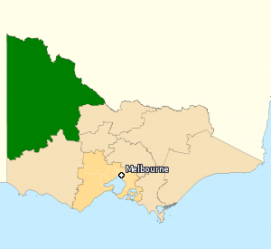



Geography and character
Mallee is the largest Division by area in the state of Victoria, covering more than 70,000 square kilometres. It spans farmland, dryland cropping and pastoral country, along with irrigated horticulture concentrated around river towns. The climate is generally dry, with hot summers and modest rainfall, and much of the native vegetation is dominated by mallee eucalypts. The electorate also overlaps parts of the Wimmera region, adding mixed farming districts and grassland environments.
Towns and communities
Major towns and regional centres give the electorate its social and economic focus. Notable population centres include:
- Mildura — an irrigation and horticultural centre on the Murray River
- Horsham — a service hub for the Wimmera agricultural district
- Swan Hill — another Murray River town with mixed farming and tourism
- Ouyen, St Arnaud and Warracknabeal — smaller towns serving surrounding farming areas
Economy and local issues
The local economy is dominated by agriculture: broadacre cropping, sheep and cattle grazing, and irrigated horticulture such as fruit and grape production. Water management, irrigation entitlements, rural services, road and rail freight links, regional health and education access are recurring political and community concerns. Seasonal variability and drought preparedness are also important to residents and local planners.
History and political profile
Created at the redistribution prior to the 1949 federal election, the Division of Mallee has been a predominantly rural electorate throughout its existence. It has generally been held by conservative parties and, in modern times, is regarded as a safe Coalition seat in federal politics. For example, in the 2013 federal election the margin placed it among the most secure Coalition-held electorates, requiring a substantial swing to change hands.
Boundaries, representation and resources
Electoral boundaries are reviewed periodically by the redistribution authority to reflect population change, so the exact area and included towns can shift between redistributions. Information about the division, past election results and current boundaries is published by electoral authorities and regional sources. For official electoral details see federal electoral resources. For state information see Victorian government sources and regional planning material at regional development pages.
Further information on the region’s natural environment and the mallee vegetation can be found through botanical and conservation references (mallee ecology, eucalypt references). Historical and electoral analysis is available from political archives and election studies (electoral history).
Note: This article is a general introduction. For up‑to‑date boundaries, current member representation and detailed statistics consult official electoral and government sources linked above.
Questions and answers
Q: What is the Division of Mallee?
A: The Division of Mallee is an Australian Electoral Division in the state of Victoria.
Q: Where is the Division of Mallee located?
A: The Division of Mallee is located in the far north-west of Victoria.
Q: How big is the Division of Mallee?
A: The Division of Mallee is the largest Division in Victoria, covering an area of 70,694 square kilometres (27,295 sq mi).
Q: What towns are included in the Division of Mallee?
A: The Division of Mallee includes Mildura, Ouyen, Swan Hill, St Arnaud, Warracknabeal, and Horsham.
Q: Why was the Division of Mallee named after the Mallee region?
A: The Division of Mallee was named after the Mallee region of Victoria, where it is located. Mallee is a variety of eucalyptus.
Q: What other region is included in the Division of Mallee?
A: The Division of Mallee also includes the Wimmera region of Victoria.
Q: Which party has historically held the Division of Mallee?
A: For the 2013 election, the Division of Mallee was the safest Coalition seat in federal parliament, with a swing of 24% needed for it to change parties.
Related articles
Author
AlegsaOnline.com Division of Mallee (Australian federal electoral division) Leandro Alegsa
URL: https://en.alegsaonline.com/art/27927
Sources
- aec.gov.au : "Profile of the electoral division of Mallee (Vic)"
- adb.anu.edu.au : "Turnbull, Sir Winton George (1899–1980)"