Division of Charlton (Australian federal electoral division)
Former Australian federal electorate in New South Wales, created 1984 and named for Matthew Charlton; located in the Hunter Region and abolished by a 2015 redistribution that moved its area into Hunter.
The Division of Charlton was an Australian federal electoral division located in the Hunter Region of New South Wales. First established at the 1984 redistribution, it was named after Matthew Charlton, a prominent early 20th‑century Labor leader. The electorate covered suburban and semi‑rural communities west and south of Newcastle and included residential suburbs, industrial sites and peri‑urban hinterland.
Image gallery
5 Images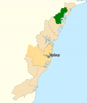


Boundaries and character
Charlton encompassed a mix of coastal suburbs, lake communities and former coal‑mining towns. Typical population centres within the division included Cardiff, Wallsend, Toronto, Morisset, Cooranbong, Glendale and Warners Bay. Its geography combined commuter suburbs for the Newcastle area with local industries such as coal, manufacturing and port‑related services. The electorate’s social and economic profile featured working‑class suburbs, growing residential developments and areas with strong community ties to mining and manufacturing.
Creation, name and political context
The seat was created in 1984 and took its name from Matthew Charlton, who led the Australian Labor Party in the 1920s. As with many Hunter Region divisions, Charlton was often regarded as part of Labor’s traditional heartland because of its historical links to mining and trade unionism. Its boundaries were determined and adjusted according to Australia’s redistribution process, which aims to keep electorates of similar enrolment size while respecting community interests and geographic features.
Abolition and redistribution
In October 2015 the Australian Electoral Commission (Australian Electoral Commission) announced a redistribution that affected New South Wales. Population changes meant the state lost a seat overall and boundaries were redrawn. Because the Division of Hunter is an original Federation electorate, redistribution guidelines gave the name Hunter priority; as a result the territory formerly in Charlton was moved into a reconfigured Hunter. The AEC indicated the change would take effect at the next federal election, and Charlton ceased to exist as a separate division following that redistribution. For official explanations of the redistribution process see the AEC materials and maps about electoral divisions.
Uses and relevance
Electoral divisions like Charlton serve as the basis for representation in the House of Representatives. Studying Charlton illustrates how redistributions respond to population shifts and the competing priorities of preserving historical electorate names and maintaining balanced representation. The changes that removed Charlton underline how demographic movement—urban growth in some regions and relative decline in others—affects parliamentary geography.
Notable distinctions and further reading
- The division was named for Matthew Charlton, leader of the Australian Labor Party in the 1920s; see general biographical sources on Charlton for context Matthew Charlton.
- It lay entirely within the state of New South Wales and shared economic links with other Hunter Region electorates such as the Division of Hunter.
- Changes to Charlton were part of a broader redistribution process; official rules and procedures are published by the Australian Electoral Commission and explanatory material on Australian political parties can be found via resources about the Australian Labor Party.
For maps, historical boundaries and electoral results consult authoritative electoral atlases and the AEC’s redistribution reports; these provide detailed breakdowns of how Charlton’s borders shifted over time and how its communities were reassigned in the 2015 redistribution (electoral division information, AEC reports).
Questions and answers
Q: What was the name of the Australian Electoral Division in New South Wales?
A: The Division of Charlton.
Q: Who was it named after?
A: It was named for Matthew Charlton, leader of the Australian Labor Party 1922-28.
Q: What area did it cover?
A: It covered the Hunter Region area of New South Wales and included towns such as Cardiff, Wallsend, Toronto, Morisset, Cooranbong, Glendale and Warners Bay.
Q: When did it become obsolete?
A: In October 2015 the Australian Electoral Commission said that the division would be renamed at the next election due to population changes in New South Wales which resulted in one division being lost and a new one created in Western Australia.
Q: What happened to its former area when it became obsolete?
A: The old Division of Hunter was abolished and its area moved eastward to take over Charlton's former area.
Q: Why does this change involve keeping the Hunter name?
A: Because Hunter is an original Federation electorate, the Australian Electoral Commission's guidelines for redistributions means it has to try and keep the Hunter name.
Related articles
Author
AlegsaOnline.com Division of Charlton (Australian federal electoral division) Leandro Alegsa
URL: https://en.alegsaonline.com/art/27851
Sources
- aec.gov.au : "Profile of the electoral division of Charlton (NSW)"
- abc.net.au : Australian Electoral Commission to abolish Federal NSW seat of Hunter: ABC 16 October 2015
- blogs.crikey.com.au : Draft federal redistribution of New South Wales: Poll Bludger
- abc.net.au : abc.net.au/news/elections/federal/2016/guide/hunt
- smh.com.au : "Liberal candidate Kevin Baker stands down over offensive website"