Delft — Dutch city of Delftware, Vermeer, and TU Delft
Historic city in South Holland, Netherlands, known for Delft Blue pottery, Johannes Vermeer, the Nieuwe Kerk royal tombs, and the Delft University of Technology.
Delft is a historic city in the province of South Holland in the Netherlands, situated roughly midway between Rotterdam and The Hague. With a compact medieval centre, networks of canals and a population of about 100,000, Delft combines a preserved old-town atmosphere with a lively contemporary university environment. The city is a frequent destination for visitors interested in Dutch Golden Age history, traditional crafts and applied sciences.
Founded in the Middle Ages, Delft developed into an important market and administrative centre. It gained particular prominence during the 17th century—often called the Dutch Golden Age—when painters, merchants and intellectuals contributed to its cultural life. Delft is closely associated with the painter Johannes Vermeer, who lived and worked there, and with the political history of the Netherlands: William of Orange (William the Silent) was assassinated in Delft and entombed in the Nieuwe Kerk, establishing a tradition of royal burials that continues to this day.
Delftware, commonly known as Delft Blue, is one of the city's best-known products. Originating in the 16th–17th centuries as a local earthenware imitating Chinese porcelain, it developed into a distinctive blue-and-white pottery style produced by several manufactories and workshops around the city. The craft remains an important cultural and tourist attraction: museums, demonstration studios and souvenir shops preserve and explain the techniques used to decorate earthenware with cobalt pigment.
Image gallery
10 Images


Institutions and landmarks
- Nieuwe Kerk (New Church): notable for its tower, city views and royal crypts.
- Oude Kerk (Old Church): medieval church famous for its leaning tower and historic tombs.
- Prinsenhof: formerly a monastery and later the residence associated with William of Orange; now a museum on local history.
- Delft University of Technology (TU Delft): a major technical university founded in the 19th century, central to Delft's contemporary identity.
Delft combines heritage tourism with cutting-edge research. TU Delft draws students and academics from around the world and supports innovation in engineering, architecture and the sciences. The city also hosts museums devoted to Vermeer, to ceramics and to local history, and retains active pottery studios where traditional Delft Blue techniques are taught and practised.
Accessible by rail and road from nearby urban centres, Delft functions as both a commuter town for the Randstad conurbation and a cultural destination in its own right. Visitors are attracted to its market square, canals, historic houses and regular events such as open-air markets and seasonal festivals. While preserving its architectural heritage, the city continues to evolve as a centre for education, design and small-scale manufacturing, blending past and present in a compact urban setting.
For further practical information, transport options and cultural listings consult local guides and municipal resources available in English and Dutch. The city’s mix of museums, academic life and artisanal production makes Delft a distinctive example of how historic European towns adapt to modern demands while maintaining a visible connection to their past.
South Holland | Netherlands | Rotterdam | The Hague | Delft University of Technology
Geography
Geographical position
Delft is located in the province of South Holland in the west of the Netherlands, halfway between Rotterdam and The Hague and about 15 kilometres from the North Sea coast and the beaches at Kijkduin or Monster. The city is part of the Randstad conurbation, where about 40 percent of the Dutch population lives.
The city lies two to four metres below sea level and is embedded in a polder landscape criss-crossed by numerous drainage ditches and canals. These shallow polders are diked, formerly flooded areas that have been pumped dry and drained and in which the groundwater level is artificially regulated. Since the end of the 14th century, windmills have been used for this purpose as scooping and pumping mills for drainage.
The Schie and the Vliet run through the city as part of the Rhine-Schie Canal, which connects the Nieuwe Maas and the Oude Rijn and stretches from Schiedam and Rotterdam via Delft and Voorburg to Leiden.
Geology
The geology of the coastal areas of South Holland is determined by the rivers that flow into the North Sea there. In particular, the Rhine, Meuse and Scheldt rivers and their tributaries have provided a large quantity of sediments that have led to the formation of the Rhine-Meuse Delta. The older rocks have sunk into deeper layers; thus the geological situation is similar to that found in many other geologically young subsidence areas.
Along the coast of South Holland, the surface soil layers of the coastal strip consist mainly of clay and marl deposits, which are often overlain by lowland bogs in higher areas inland. The clays were deposited after the sea level began to rise in the postglacial period (transgression). The higher areas are glacially deformed.
The area around Delft has clastic sediments such as clay and sand, especially drift sand.
Land use
The urban area extends over an area of 24.08 square kilometres. In 2003, before a boundary change between Delft and Midden-Delfland, the Centraal Bureau voor de Statistiek (CBS) measured the land use in detail. At that time, Delft had an area of 26.31 square kilometres, of which 7.40 square kilometres, or about 28 percent, were residential and 6.63 square kilometres, 25 percent, were agricultural use, including intensive crops in greenhouses.
Neighboring communities
The location and distance of adjacent communities is as follows:
| Rijswijk | The Hague | Pijnacker-Nootdorp |
| Midden-Delfland |
| Pijnacker-Nootdorp |
| Midden-Delfland | Schiedam | Rotterdam |

City breakdown
Delft is divided into the following districts (wijk/wijken):
- Wijk 11 - Binnenstad (city centre)
- Wijk 12 - Vrijenban
- Wijk 13 - Hof van Delft
- Wijk 14 - Voordijkshoorn
- Wijk 16 - Delftse Hout
- Wijk 22 - Tanthof-West
- Wijk 23 - Tanthof-Oost
- Wijk 24 - Voorhof
- Wijk 25 - Buitenhof
- Wijk 26 - Abtswoude
- Wijk 27 - Schieweg
- Wijk 28 - Wippolder
- Wijk 29 - Ruiven
Climate
The proximity of the sea and the prevailing winds from the North Sea, which is warmed by the Gulf Stream, determine the mild and relatively humid maritime climate of the coastal areas of the Netherlands and thus also of Delft.
With a mean annual temperature of around 10 degrees Celsius, the average temperature in January is 3.6 degrees Celsius. Precipitation averages around 856 millimeters and is distributed relatively evenly throughout the year, with February and April being the driest months. In autumn, storms are frequent and can be accompanied by heavy rainfall. In winter it is wet and cold; snowfall is rare. The main characteristic of the weather, as in the whole of the Netherlands, is its changeability.
As early as the early 18th century, air pressure, precipitation and humidity were regularly recorded in Delft by Nicolaus Samuelis Cruquius, from which temperature, wind direction and wind force could later be reconstructed. The original weather observations and the later conversions are kept at the Royal Netherlands Meteorological Institute (KNMI).
The climate table (long-term average 1981-2010), recorded by the weather station Rotterdam/Delft, which is located near the airport Rotterdam Den Haag, about 10 km southeast of the city limits of Delft, shows the details of the Delft climate:
| Rotterdam/Delft | ||||||||||||||||||||||||||||||||||||||||||||||||
| Climate diagram | ||||||||||||||||||||||||||||||||||||||||||||||||
| ||||||||||||||||||||||||||||||||||||||||||||||||
| Monthly average temperatures and precipitation for Rotterdam/Delft
Source: Koninklijk Nederlands Meteorologisch Instituut | |||||||||||||||||||||||||||||||||||||||||||||||||||||||||||||||||||||||||||||||||||||||||||||||||||||||||||||||||||||||||||||||||||||||||||||||||||||||||||||||||||||||||||||||||||||||||||||||||||||||||||||||||||||||||||||||||||||||||||||||||||||||||||||||||||||||||||


Population
With an average of 484 inhabitants/km², the Netherlands is one of the most densely populated countries in the world (compared to Germany: 231 inhabitants/km²). Delft, as part of the Randstad conurbation, has a particularly high population density, as does this area as a whole: On 1 January 2007, 4,151 inhabitants/km² lived in Delft's urban area. In The Hague, nine kilometres to the north-west, this population density is significantly exceeded, with 5,738 inhabitants/km², while in Rotterdam, 14 kilometres to the south of Delft, it is a comparatively low 2,824 inhabitants/km².
On 1 January 2007, Delft had 95,382 inhabitants, whose number had grown to 96,055 inhabitants on 1 February 2008. In 2007, the number of households was 52,885, with an average size of 1.8 persons. 54 percent of the households were single people. A total of 2370 families lived in Delft, of which 13 percent were single parents. The constant decrease in families with children is striking; in 2007 there were still 8995 - a decrease of 11 percent compared to 2002. Also, contrary to the Dutch trend, Delft records comparatively few children aged 0 to 1 and adults aged 35 to 74.
The most striking feature of the Delft population pyramid is the proportion of men between the ages of 20 and 30. In 2002, this proportion was about twice as high as the Dutch average. The proportion of women in this period of life was around 25 percent higher than the Dutch average. The reason for this is the Delft University of Technology, which currently has 14,300 students enrolled, of which only 2,800 are women.
Development of the number of inhabitants
The population of Delft more than tripled in the 20th century. Since the late 1990s, however, there has been stagnation, leading to a population decline for the first time in 2003, which intensified in subsequent years but was marked by slight recoveries in 2004 and 2007.
| Year1 | Male | Female | Total |
| 1900 | 15.296 | 16.293 | 31.589 |
| 1920 | 19.547 | 18.886 | 38.433 |
| 1940 | 27.541 | 27.416 | 54.957 |
| 1960 | 37.947 | 35.349 | 73.323 |
| 1980 | 42.940 | 40.971 | 83.911 |
| 2000 | 50.299 | 45.802 | 96.101 |
| 2002 | 50.636 | 46.325 | 96.961 |
| 2003 | 50.531 | 46.075 | 96.606 |
| 2004 | 50.084 | 45.707 | 96.791 |
| 2005 | 49.655 | 45.381 | 95.036 |
| 2006 | 49.710 | 45.380 | 95.090 |
| 2007 | 49.867 | 45.512 | 95.379 |
| 2008 | 50.416 | 45.752 | 96.168 |
| 2009 | 50.618 | 45.899 | 96.517 |
| 2010 | 50.848 | 45.912 | 96.760 |
| 2011 | 51.652 | 46.038 | 97.690 |
| Foreigners | 14.221 | 12.657 | 26.878 |
| Percentage of foreigners | 28,5 % | 27,8 % | 28,15 % |
1Every 1 January 2acc. to CBS definition
Source: Statistics of the municipality of Delft, as of January 2007
Population with foreign background
In 2007, 8,332 people with a non-Dutch nationality lived in Delft. This corresponds to 8.7 percent of the population and is distributed among 147 different nationalities. The statistics of the Netherlands, however, only marginally deal with different citizenship and ethnicity, rather primarily with ethnicity. All those people are considered to belong to a different ethnic group - and thus to be foreigners - who were either born abroad themselves or had a parent or grandparent born abroad. Accordingly, in 2007, 29.1 per cent of the population of Delft were of a different ethnic origin (as of 1 January 2007: 27,803 compared to 57,579 Dutch), while the national average is less than 20 per cent.
As is the case everywhere in the Netherlands, the statistics distinguish between citizens of "westerse landen", which includes most EU countries and the USA, and "niet westerse landen" for all other countries in the world. Former citizens of the former Dutch colonies of Indonesia and New Guinea are also listed separately under "westerse landen", even if they have been living in the Netherlands for more than two generations as Dutch citizens anyway, while persons originating from Aruba are listed as "allochthones" from the "niet westerse landen", although Aruba is an autonomous part of the Kingdom of the Netherlands.
The group of citizens from the "westerse landen" comprises well under 5,000 persons, is headed by a group of 1,670 Germans and in its entirety mainly concerns European officials, for example of the European Patent Office located in Rijswijk near Delft, and their families, most of whom have not settled permanently in the Netherlands, but return to their home countries at the end of their secondment or at the end of their period of service. However, this also applies to parts of the remaining EU citizens as well as Turkey, which is one of the member states of the European Patent Organisation.
The group of citizens from the "niet westerse landen" is led by Turks with 2366 persons, followed by Surinamese with 2303 and nied. Antilles/Aruba with 1519 persons.
Religions
· 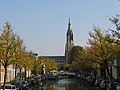
The Nieuwe Kerk on the market square. William of Orange is buried here
· 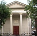
The synagogue at Koornmarkt
· 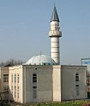
The Sultan Ahmed Mosque on the Martinus Nijhofflaan
According to the survey Permanent Onderzoek Leefsituatie (POLS) of the Centraal Bureau voor de Statistiek (CBS) from 2001 to 2003, in 2000/2003 29.7 percent of the Delft population were of Roman Catholic faith and 24.8 percent belonged to one of the Protestant churches; 5.2 percent professed Islam. 37.6 percent did not belong to any religious community.
Hippolytus of Rome is the patron saint of the city. Until the Reformation in 1583, the Oude Kerk was dedicated to him. In 1804 the newly founded Catholic parish of the Old Town of Delft was named after him, and in 1972 the former chapel of the Delft Holy Spirit Sisters, the Sint Hippolytuskapel. Since 1971, the neo-Gothic Maria van Jessekerk has been the parish church of the Roman Catholic community in Delft, which also includes four other churches and is dedicated to St. Ursula of Cologne.
In 1821 a Jewish community was founded in Delft, but it never numbered more than about 200 people. In 1840 a small Jewish school and a cemetery were established near today's Vondelstraat and Geertruyt van Oostenstraat, and in 1862 a synagogue was built at Koornmarkt 12. During the Second World War most of the Jewish inhabitants were deported and murdered. After the war, the Delft Jewish community was merged with The Hague. The synagogue has been preserved, renovated and is available for religious and cultural events.
The Muslim community of Delfts comprises around 2300 people. The Sultan Ahmed Mosque at Martinus Nijhofflaan 80 dates from 1995.


Questions and answers
Q: Where is Delft located?
A: Delft is located in the province South Holland in the Netherlands.
Q: What is the distance between Rotterdam and The Hague?
A: Delft is about halfway between Rotterdam and The Hague.
Q: What is Delft famous for?
A: Delft is famous for its Delft Blue pottery and the Delft University of Technology.
Q: Which royal family is buried in Delft?
A: The royal family, which includes the kings and queens, is buried in Delft.
Q: What is the population of Delft?
A: Delft has a population of about 94,000 inhabitants.
Q: Which province is Delft located in?
A: Delft is located in the province South Holland in the Netherlands.
Q: What can be found in Delft besides its famous pottery and university?
A: Delft is also the burial place for the royal family.
Related articles
Author
AlegsaOnline.com Delft — Dutch city of Delftware, Vermeer, and TU Delft Leandro Alegsa
URL: https://en.alegsaonline.com/art/26384