Deccan Plateau — South-Central Indian Upland
A broad, elevated triangular region covering much of peninsular India. Describes its geography, geology (Deccan Traps), ecosystems, human use, and boundaries formed by surrounding mountain ranges.
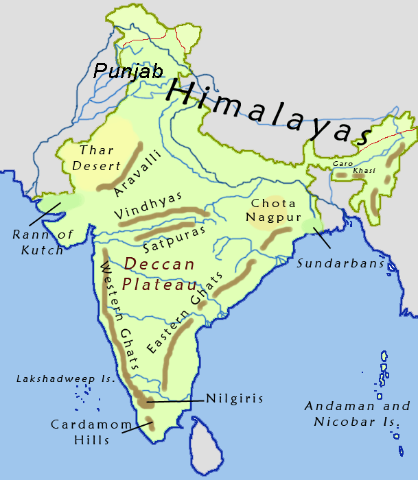
The Deccan Plateau is a vast elevated region occupying much of peninsular or southern India. It forms a broad, roughly triangular upland that rises above surrounding coastal plains and river lowlands, and it has a distinctive geological and ecological identity. For a general depiction see the map and its position within South India. The plateau is bounded by mountain chains and transitions gradually into other landscapes rather than ending in a single cliff.
Image gallery
10 Images


Geography and extent
The plateau covers a large portion of the Indian subcontinent and extends over eight Indian states, principally Telangana, Maharashtra, Andhra Pradesh, Karnataka, Kerala and Tamil Nadu. Its upland forms a triangle whose southern vertex points toward the tip of the peninsula. The plateau's elevation varies: the southern portion is generally higher, often exceeding levels described at higher altitudes, while northern areas are lower and merge into broad plains. The upland’s interior contains many different habitats and local landforms.
Geology and origin
The Deccan Plateau is underlain by extensive volcanic basalt known collectively as the Deccan Traps, produced by massive lava flows late in the Mesozoic to early Cenozoic eras. This volcanic foundation shapes the region's soils and drainage and contributes to its characteristic flat-topped hills and step-like escarpments. The plateau's overall geology and internal relief create varied substrata and mineral deposits that have influenced human settlement and land use over millennia. For geological context see the notes on geology.
Ecology and climate
The Deccan hosts a mosaic of ecosystems ranging from dry deciduous forests and scrub to pockets of moist evergreen forest in the adjacent hills. These ecosystems reflect gradients in rainfall and temperature; the region’s climate varies from semi-arid interiors to wetter western and southern slopes. The Western and Eastern Ghats that flank the plateau are important for rainfall capture and biodiversity: the Western slopes uplifted as the mountain ranges on the west and the Eastern Ghats on the east create rain shadows and biological corridors. Many forest types on the plateau are very old compared with younger mountain systems.
Rivers, resources and human use
Major rivers that drain the plateau create fertile valleys and support irrigation and agriculture. The plateau’s soils and flat uplands favor a mix of dry-farming crops and irrigated agriculture fed by rivers and reservoirs. Urban centres and historic cities are scattered across the upland and draw on its mineral, agricultural and water resources. Human activities have shaped landscape patches, while the northern rim formed by the Satpura and Vindhya ranges separates the Deccan from the densely farmed riverine plains to the north.
Distinctive features and significance
Key features of the Deccan Plateau include its triangular form, widespread volcanic bedrock, varied elevations and a large range of habitats. The plateau has been a major theatre for cultural and economic development in peninsular India and remains important for biodiversity, agriculture, mineral wealth and urban growth. For introductory resources and regional outlines consult general references and illustrated maps linked above for further orientation.
- Major characteristics: broad basaltic upland, diverse habitats, variable climate.
- Boundaries: mountain ranges including the Eastern Ghats and western escarpments, and northern ranges such as the Satpura Range.
- Administrative extent: spans several states including Telangana, Maharashtra, Andhra Pradesh, Karnataka, Kerala, Tamil Nadu.
For mapping, ecological inventories and geological summaries consult the resources indicated by the embedded links above: they provide accessible starting points to explore the plateau’s physical form, biological richness and human dimensions.

Geography
A distinction must be made between the entire Deccan and the highlands of Deccan. The plateau extends in the north to the countryside around the river Tapti and borders there on the mountain ranges of Satpura, in the west and east the mountain ranges of the Westghats and Eastghats form the boundaries, which almost collide in the south. It is a table-land, undulating in the east, flattening towards the west and forming extensive plains. The Deccan Trapp in the northwest is one of the largest basaltic areas on earth, covering about 500,000 km². In the west the heights of the Deccan Plateau are 1000 to 1300 m, in the center 500 to 600 m. The rivers originating in the Western Ghats flow through the plateau in an easterly direction and flow into the Bay of Bengal.
In addition to isolated areas of alluvial and diluvial soils, fertile black earth and laterite soils predominate. The Deccan Plateau is relatively dry because the southwest monsoon is held off by the Western Ghats. Agriculture is therefore dependent on irrigation.


Population
Questions and answers
Q: What is the Deccan Plateau?
A: The Deccan Plateau is a large plateau that covers most of South India. It extends over eight Indian states and covers 422,000 square kilometres (163,000 sq mi).
Q: What are the three mountain ranges surrounding the Deccan Plateau?
A: The three mountain ranges surrounding the Deccan Plateau are the Western Ghats in the west, Eastern Ghats in the east, and Satpura Range and Vindhya Range to its north.
Q: How much of India's landmass does it cover?
A: The Deccan Plateau covers 27.7 percent of India's landmass.
Q: How high is it above sea level?
A: In the south of India, it is mostly over 1,000 metres (3,300 ft) above sea level while in the north it is mostly about 500 metres (1,600 ft) above sea level.
Q: What type of habitats can be found on this plateau?
A: There are many different habitats on this plateau with different ecosystems containing different sorts of vegetation, climate, geology and animals.
Q: How old are these forests compared to other mountains in India?
A: These forests on this plateau are older than those found on Himalayan mountains.
Q: What shape does this triangle form when looking at a map?
A: When looking at a map from an aerial view or satellite image ,the uplands form a downward-pointing triangle within India's coastline.
Related articles
Author
AlegsaOnline.com Deccan Plateau — South-Central Indian Upland Leandro Alegsa
URL: https://en.alegsaonline.com/art/26121
Sources
- britannica.com : Encyc Brit
- rainwaterharvesting.org : "The Deccan Plateau"
- ibiblio.org : Monier-Williams Sanskrit-English Dictionary, p. 498
- mantleplumes.org : The Deccan beyond the plume hypothesis
- sciencedaily.com : India's smoking gun: Dino-killing eruptions
- sciencemag.org : "The Chicxulub asteroid impact and mass extinction at the Cretaceous-Paleogene Boundary"
- worldcat.org : 1095-9203
- worldcat.org : 1052-5173