Davos: Alpine town, resort and international conference host
Davos is a Swiss alpine municipality and ski resort in Graubünden, known for winter sports, sanatoria history, the EHC Davos hockey club and as the annual host of the World Economic Forum.
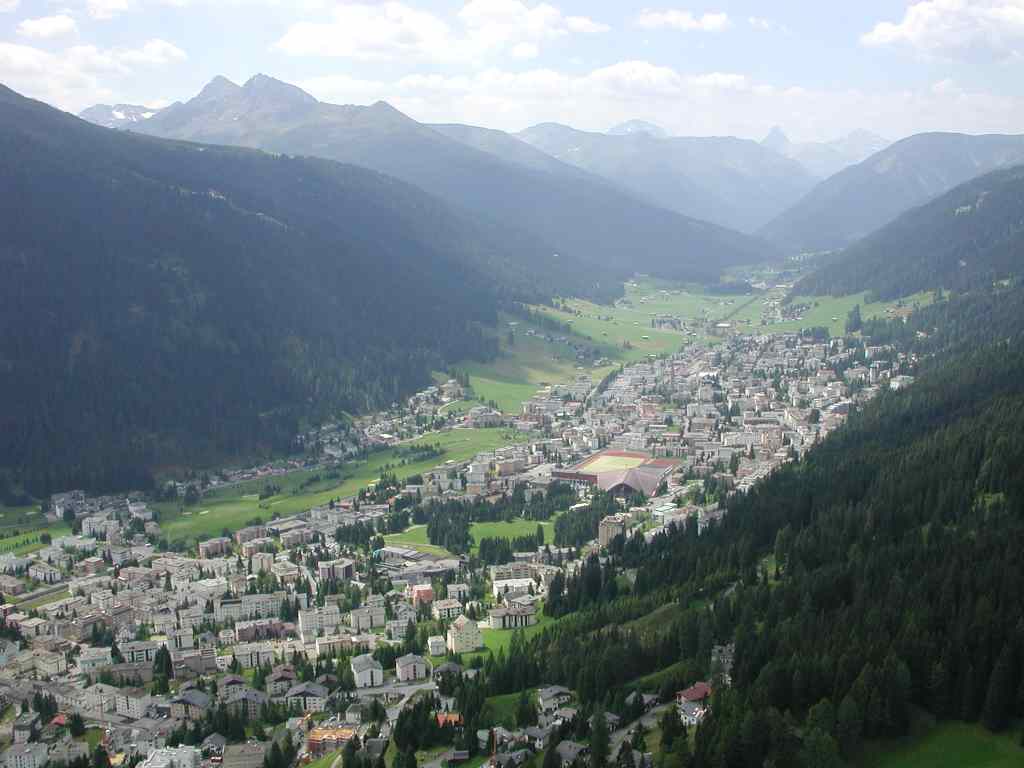
Davos is a high‑altitude town and a prominent alpine resort in eastern Switzerland. Administratively it is a municipality in the local district, commonly referred to as Davos, within the Swiss canton of Graubünden. The settlement has traditional names in regional languages: Tavau in Romansh and Tavate in Italian. It combines year‑round tourism, a resident community and regular international gatherings.
Image gallery
10 Images


Geography and alpine environment
Davos lies in a broad mountain valley with access to several nearby peaks and ski areas. Its landscape and climate have long made it attractive for outdoor recreation: skiing, cross‑country trails, hiking and mountain biking are available seasonally. As a well‑known ski resort, Davos offers lifts, marked runs and maintained winter‑sports infrastructure while also serving as a base for excursions into neighbouring valleys.
Winter sports and local clubs
Sporting life is important to the town. Davos supports competitive and amateur ice sports: the professional ice hockey club EHC Davos plays at a well‑known stadium, and the town hosts regional and international winter‑sports competitions. Facilities cater to families, club athletes and visitors seeking organised outdoor activity.
History and health tourism
In the 19th and early 20th centuries Davos became famous as a destination for health and convalescence, with sanatoria that promoted mountain air and rest for patients with respiratory conditions. This medical reputation helped develop early tourist infrastructure and attracted visitors from across Europe, a legacy reflected in the town's architecture and cultural memory.
International events and economy
Davos is widely known as the recurring host of the World Economic Forum, an annual meeting that brings political, business and academic leaders to the town each winter. The local economy combines hospitality, conference services, retail and outdoor recreation; seasonal tourism is a major component, supported by hotels, restaurants and service businesses.
Transport, culture and visitors
The town is accessible by regional rail and road, and functions as a transport hub for nearby mountain resorts and trails. Cultural offerings include museums, concerts and public programming that serve both residents and tourists. Davos is often cited as an example of an alpine community that manages the demands of large events while maintaining local services and recreational opportunities.
Quick facts
- Local names: Tavau (Romansh), Tavate (Italian).
- Municipality and resort in Graubünden, Switzerland.
- Known as a year‑round ski resort with extensive winter facilities.
- Home to EHC Davos (ice hockey) and its stadium.
- Recurring host of the World Economic Forum.
- Part of the local administrative district within the canton of Graubünden.
Coat of arms
Blading: Foursquare of blue and gold, covered with a cross in mixed colours.
Surviving coat of arms of the Zehngerichtebund. Probably the original coat of arms of the Zehngerichtebund was a yellow cross on a blue background. This colour distribution and the cross shape were clearly visible and easy to describe.
Geography
See also: List of mountains in the Davos landscape
Davos landscape
The territory of the Davos landscape comprises most of the Landwasser valley and extends a good two kilometres beyond the watershed into the Prättigau at Davos Wolfgang (1631 m). The axis of the valley, marked by the river, main road and railway line, runs from northeast to southwest. From the Davosersee, it initially slopes very gently, only just under 60 metres over a length of eight kilometres. In this section, the two side valleys of Flüela and Dischma flow into the valley from the left, providing access to the Flüela Pass and Scaletta Pass, respectively, which lead into the Engadine. From the confluence of the third side valley, the Sertigtal, which is about 10 km long like the aforementioned ones, the valley floor becomes narrower and drops by almost 300 metres over the remaining nine kilometres to the former municipal boundary at the Felsenge Brombänz. The deeply cut lower section of the valley is called Zügenschlucht. Beyond the Zügenschlucht is the fraction of Wiesen, which has also belonged to Davos since 1 January 2009.
The right (north-western) flank has only a few short side valleys. Here the municipal boundary - at the same time watershed against the Plessur region - runs over the summits of Amselflue (2771 m), Tiejer Flue (2781 m), Mederger Flue (2674 m) and Chüpfenflue (2658 m) to the historically important Strelapass. Beyond the saddle it continues over the Schiahorn (2709 m) to the Weissflue (2834 m). To the north, the municipal boundary runs along the Casanna and Gotschnagrat. The left side of the valley is dissected by the three side valleys into protruding ridges. Viewed from the valley, the mountains Seehorn (2238 m), Büelenhorn (2512 m), Jakobshorn (2590 m) and Rinerhorn (2528 m) dominate the scene. The highest peaks, however, are found along the watershed towards the Engadine and the upper Albula valley: Flüela Wisshorn (3085 m), Flüela Schwarzhorn (3147 m, highest point in the municipality), Piz Grialetsch (3131 m), Chüealphorn (3078 m) and Hoch Ducan (3063 m).
Villages of Davos
The six districts - autonomous fractional municipalities until the end of 2018 - are in the direction of flow of the river Landwasser:
- Davos Dorf, including the Flüela valley, the settlement of Wolfgang with the road crossing Passhöhe Wolfgang and the hamlet of Laret beyond the pass,
- Davos Platz, including the Dischma Valley,
- Davos Frauenkirch, including the Sertig valley,
- Davos Glaris
- Davos Monstein (since 2019 the only local authority under public law in the municipality)
- Davos Meadows
The Frauenkirch, Glaris and Monstein fractions together form the undercut, while the Platz and Dorf fractions form the overcut.
The two largest fractions, Dorf and Platz, lie in the almost flat upper section of the valley and have merged into an approximately four-kilometre-long band of settlements as a result of building activity in the 20th century. A large number of individual farms and alpine settlements are scattered throughout the municipality.
With 254.54 km², Davos was the second largest municipality in Switzerland in terms of area until the beginning of 2009. In 1997, 37.1 % of the area was used for agriculture as meadows and pastures, the forest took up 19.7 % and settlements 2.2 %. Unproductive land accounted for 41.0 %.
With the incorporation of Wiesen, Davos became Switzerland's largest municipality by area at the beginning of 2009, just ahead of Bagnes (282 km²), but lost this leading position again at the beginning of 2011 to the newly created municipality of Glarus Süd.
Neighbouring communities are Arosa, Bergün Filisur, Klosters-Serneus, S-chanf, Schmitten and Susch.
Climate
According to Köppen, Davos has a cold, wet winter climate with cool summers (Dfc). The annual mean temperature is 3.5 °C, with the coldest monthly mean temperatures in January at -4.9 °C and the warmest monthly mean temperatures in July at 12.4 °C. On average, around 193 frost days and 58 ice days can be expected here. There are an annual average of 3.5 summer days, and no heat days were recorded in the 1981-2010 normal period. The MeteoSwiss weather station is located at an altitude of 1594 m above sea level.
| Davos, 1981-2010 | ||||||||||||||||||||||||||||||||||||||||||||||||
| Climate diagram | ||||||||||||||||||||||||||||||||||||||||||||||||
| ||||||||||||||||||||||||||||||||||||||||||||||||
| Monthly average temperatures and precipitation for Davos, 1981-2010
Source: | |||||||||||||||||||||||||||||||||||||||||||||||||||||||||||||||||||||||||||||||||||||||||||||||||||||||||||||||||||||||||||||||||||||||||||||||||||||||||||||||||||||||||||||||||||||||||||||||||||||||||||||||||||||||||||||||||||||||||||||||||||||||||||||||||||||||||||
The heat record in Davos was set on 27 June 2019 at 29.8 °C.


Related articles
Author
AlegsaOnline.com Davos: Alpine town, resort and international conference host Leandro Alegsa
URL: https://en.alegsaonline.com/art/25853