
Dardanelles (Hellespont): the strait between the Aegean Sea and the Sea of Marmara
A narrow Turkish strait linking the Aegean Sea to the Sea of Marmara, separating Europe and Asia and long known for its strategic, cultural, and literary significance.
Overview
The Dardanelles is a narrow maritime passage in northwestern Turkey that connects the Aegean Sea to the Sea of Marmara. It forms part of the natural corridor between the Mediterranean and the Black Sea system and traditionally marks the geographic division between Asia to the east and Europe to the west. Because of this location, the strait has been a focal point for trade, navigation and military activity for millennia.
Image gallery
10 Images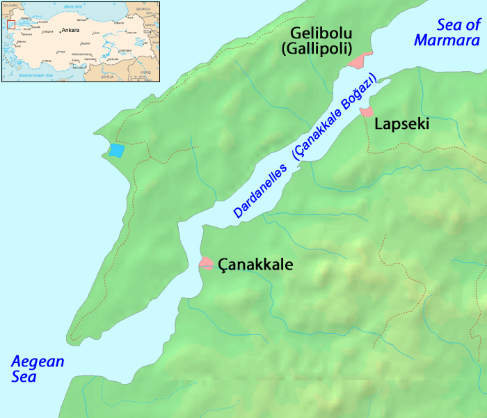





Geography and physical features
The Dardanelles is relatively narrow and winding, with alternating stretches of steep coastlines and small bays. Strong tidal currents and variable winds influence navigation. Several towns and ports line its shores and ferries, fishing boats and commercial vessels routinely cross the channel. Its waters link into wider maritime routes that continue north through the Bosporus toward the Black Sea.
History and cultural importance
In antiquity the strait was known as the Hellespont, a name that appears repeatedly in Ancient Greek literature and myth. It features in legendary accounts of the Trojan War and later classical tales such as the story of Leander and Hero. Over the centuries it has seen the movement of armies, traders and migrants, and it has been a contested frontier between empires because controlling the strait meant controlling access between seas.
Strategic role and modern governance
As an international waterway, the Dardanelles has strategic military and commercial value. In the 20th century it was the scene of major campaigns and remains central to regional security. The legal regime governing passage and naval access has been shaped by international agreements; coastal sovereignty is exercised by Turkey while international navigation rights are recognized and regulated to balance security and free passage.
Uses, economy and environment
The strait supports commercial shipping, local fisheries, ferry services and tourism. Modern infrastructure such as vehicle and rail crossings coexist with traditional maritime activities. The area is also environmentally sensitive: currents, brackish water layers and migrating marine species create distinct ecosystems that are vulnerable to pollution and heavy traffic.
Notable facts
- The Dardanelles has had both practical and symbolic significance across civilizations.
- It connects two major inland seas and is part of routes linking the Mediterranean to the Black Sea.
- Because of its narrowness and currents, navigation requires local knowledge and careful management.
Together, these features make the Dardanelles a small but consequential strait whose geography continues to influence commerce, culture and geopolitics in the region.
Geography
The Dardanelles are located between the European peninsula of Gallipoli and northwestern Anatolia, which belongs to Asia Minor, they are the southwesternmost part of the Inner Eurasian border. The name comes from Dardanos, a settlement that was located near Troy.
This strait connects the Aegean Sea with the Sea of Marmara and, via the adjacent Bosporus, with the Black Sea. The Dardanelles are about 65 kilometres long and between 1.3 and 6 kilometres wide, with an average depth of 50 metres. On the surface, a current flows from the Sea of Marmara to the Mediterranean Sea, while an undercurrent flows in the opposite direction, due to the almost double salinity of the Mediterranean Sea compared to the Black Sea.
On the Asian coast of the Dardanelles is the port city of Çanakkale. The Çanakkale 1915 Bridge between Lapseki and Gelibolu is under construction. With 3623 meters it will be the longest bridge in Turkey. The target completion date is 2023.
History
In Greek mythology it is said that Achilles was buried in the waters of the Hellespont after his death in the Trojan War. According to tradition, the ancient places of Sestos on the European shore and Abydos on the Asia Minor shore were the setting for the story of Hero and Leander.
In the Second Persian War, the Persian king Xerxes crossed the Hellespont during his campaign against Greece in about 480 BC with two ship bridges, each consisting of over 300 ships and said to have had a temporary opening for smaller ships. Alexander the Great crossed the Hellespont in 334 BC with an army of about 35,000 Macedonians and Greeks at the beginning of his Persian campaign.
The Peloponnesian War saw several significant battles on the Hellespont, including the Battle of Cyzicus in 410 BC and the Battle of Aigospotamoi, the decisive defeat of the Athenians in 405 BC.
In 1656 there was the Battle of the Dardanelles, one of the naval engagements and battles fought by the fleets of the Republic of Venice and the Ottoman Empire for supremacy in the eastern Mediterranean.
Under the Dardanelles Treaty of 1841, only Turkish warships were allowed to pass through this strait. In the run-up to the First World War, the Dardanelles played a significant role: Russia was concerned that the German Empire would gain too much influence over the region. For this reason, Russia put pressure on the Entente to resist the German Empire in establishing a military mission. During World War I, the Dardanelles were the scene of the Battle of Gallipoli due to their strategic location, with heavy losses on both sides. Since 1936, the Treaty of Montreux has regulated the rights of passage.

Related articles
Author
AlegsaOnline.com Dardanelles (Hellespont): the strait between the Aegean Sea and the Sea of Marmara Leandro Alegsa
URL: https://en.alegsaonline.com/art/25494