Danube: Europe's Great River
The Danube is a major European river flowing 2,860 km from the Black Forest to the Black Sea, crossing ten countries and supporting transport, ecology, culture and cities from Ulm to the Danube Delta.
Overview
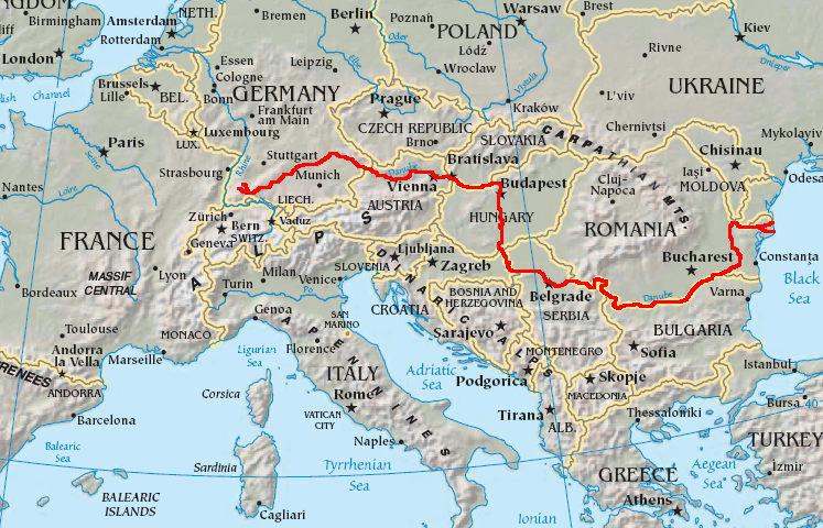
The Danube is one of Europe’s principal rivers, flowing eastward across the continent for about 2,860 km. It is traditionally described as the second-longest river in Europe and is the longest river entirely or partly within the modern European Union. In classical sources the river is also known by its Latin name Hister. Its course links central and southeastern Europe and has shaped settlement, trade and culture along its banks for millennia.
Image gallery
6 Images


Course and geography
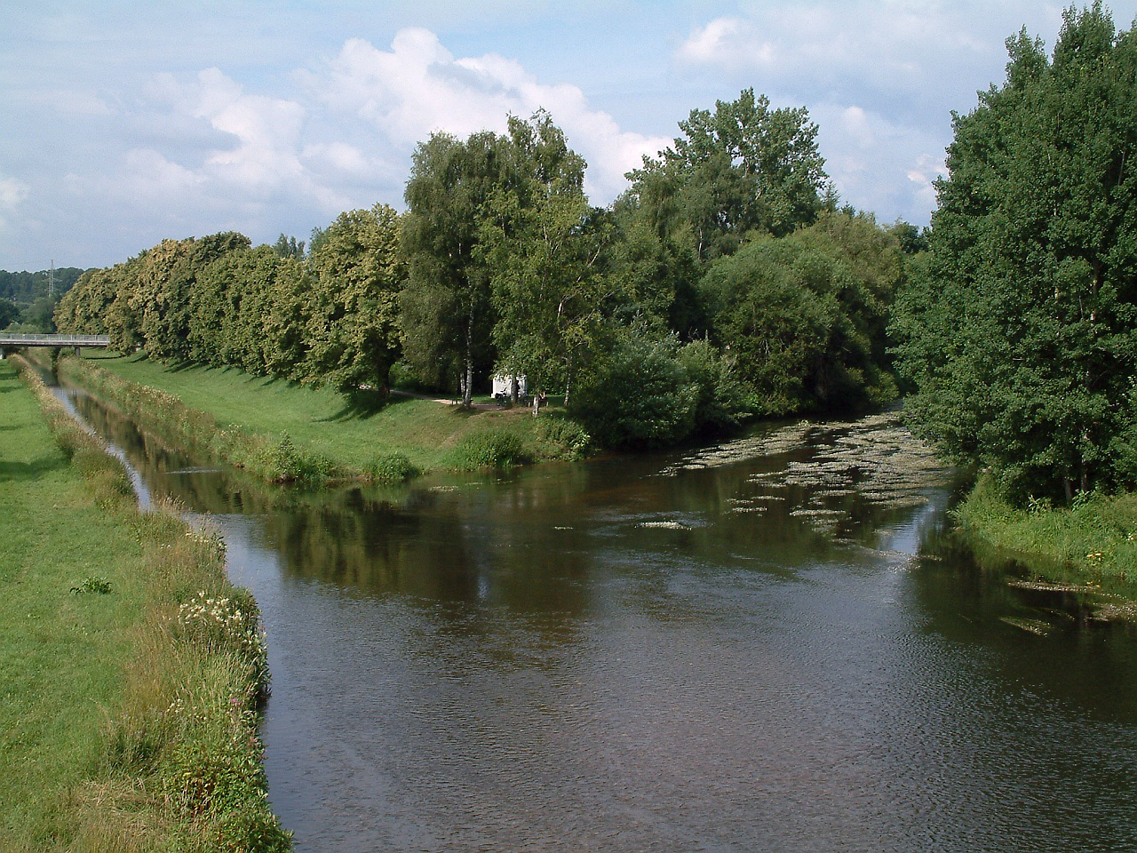
The Danube begins where two smaller streams, the Brigach and the Breg, meet at Donaueschingen near the Black Forest. From that source it travels east and southeast to empty into the Black Sea through the large Danube Delta. Along the way it forms part of international borders and crosses or touches ten countries: Germany, Austria, Slovakia, Hungary, Croatia, Serbia, Romania, Bulgaria, Moldova and Ukraine. The river crosses varied landscapes, from upland valleys and gorges to broad floodplains and coastal wetlands.
Cities and human use
Many important cities lie on the Danube or close to it. Notable urban centers along its banks include Ulm and Regensburg in Germany, Linz and Vienna in Austria, Bratislava in Slovakia, Budapest in Hungary, Novi Sad and Belgrade in Serbia, and port towns farther downstream. The Danube has long been a transport corridor: ocean-going ships can reach ports such as Brăila in Romania, river cruise vessels operate to places like Kelheim, and smaller craft navigate upstream to cities such as Ulm. Modern navigation is supported by locks, dredging and canal links that connect the Danube to other river systems.
Canals, engineering and navigation
To integrate the Danube into wider European waterways, engineers have built canals and lock systems that extend its reach and improve passage for trade and tourism. Two of the best-known connections are the Rhine–Main–Danube link, which creates a navigable route between the North Sea and the Black Sea, and the Danube–Black Sea Canal that shortens the lower Danube route to the sea. In addition to large projects there are numerous dams, flood-management works and river-training structures along the Danube and its main tributaries.
Names, languages and culture
The river has many local names reflecting the languages and peoples of its basin. Examples include German Donau, Romanian Dunăre, Bulgarian Дунав, Croatian Dunav, Serbian Дунав, Slovak Dunaj, Ukrainian Dunay, Greek Dounavis, Turkish Tuna and Esperanto Danubo. These names appear in literature, place-names and folk tradition. The river has also inspired music, art and literature and remains an important symbol of transnational connection in Europe.
Ecology and the Danube Delta
The Danube Delta is one of the largest and most biodiverse wetlands in Europe. Flowing into the Black Sea, the delta supports rich birdlife, fish spawning grounds and extensive reeds and marshes that are important for conservation and local livelihoods. Because of its ecological value it has received international recognition and protection, and scientists monitor the delta and upstream basin for water quality, habitat change and flood risk. The river’s health is integral to fisheries, agriculture, tourism and the well-being of communities across its basin.
Further reading and links
- Classical names and antiquity
- Upper Danube sources
- Donaueschingen
- Black Forest region
- Germany
- Austria
- Slovakia
- Hungary
- Croatia
- Serbia
- Romania
- Bulgaria
- Moldova
- Ukraine
- Black Sea
- Danube Delta
- Ulm
- Regensburg
- Linz
- Vienna
- Bratislava
- Budapest
- Novi Sad
- Belgrade
- Names in other languages
- Bulgarian name
- German name
- Greek name
- Croatian name
- Turkish name
- Romanian name
- Serbian name
- Slovak name
- Ukrainian name
- Ocean shipping
- Brăila port
- Kelheim navigation

Names and etymology
The Danube, like most rivers in the German-speaking world, has a feminine name. In Middle High German it was called diu Tuonowe (early New High German Tonaw, Donaw). The root word -ouwe ('river floodplain, -landscape') of its Old High German compound name may have contributed to the feminine gender of today.
All modern names of the river - including Romanian Dunărea, Bulgarian, Serbian, and Croatian Dunav, Slovenian Donava, Hungarian Duna, Turkish Tuna, and Slovak, Russian, Polish, Czech, and Ukrainian Dunaj - derive first from the name Dānuvius of Roman times (with the river god of the same name), but go back to older roots. Danube, like the river names Dnepr, Dnister, Donets, and Don, is possibly Iranian or Celtic in origin. The names could be derived from the Iranian-speaking Scythians and Sarmatians as well as from the Celts of Eastern Europe. An exact linguistic assignment is difficult, since both tribes reached the Danube and the Danube, furthermore both Celtic and Iranian are Indo-European languages and therefore the word "river" in Old Iranian (cf. Avestan dānu, Ossetian don) and Celtic (cf. Welsh Donwy) goes back to the same Indo-European root *dʰenh₂- 'to flow'. In the Celtic language family, this is said to go back to the goddess Danu (also Danann).
In ancient times, the Danube had two names for a long time: Ister or Hister, in ancient Greek Ístros (Ἴστρος), was a name for the lower course, Danube was called only the upper course. Some Roman cities on the lower reaches of the Danube bore the suffix ad Istrum - for example, Nicopolis ad Istrum. This word stands to a general Indo-European hydronym *heisr- 'fast, hurtig' and is also traced back to the Celtic words ys 'fast, tearing' and ura 'water, river'. According to another interpretation, ys also stands for 'high, low' and thus, like the Latin altus, denotes both aspects of the vertical. In the area of the former Celtic settlement area, besides the old names of the Danube, a number of other names for other rivers are derived from this stem:
- Eisack (South Tyrol, Italy)
- IJssel (Netherlands)
- Isar (Germany)
- Isel (Austria)
- Isère (France)
- Iskar (Bulgaria)
- Jizera (Czech Republic)
- Yser (Belgium)
Hans Bahlow attributed the root sound *is- with the roots *es-, *as-, *os, *us- or *aus- (all supposedly 'marsh/moor water'). Another interpretation assumes a hypothetical Indo-European root *es or *is, interpreted as a generic name for '(flowing) water'.
It was not until the turn of the century, when the Roman Empire had expanded over the entire course of the Danube and the cartographic connections were developed, that the unity of both sections of the river was recognized. Even until the end of antiquity, Ister was a common name for the river, while Dānuvius tended to refer only to the upper reaches. Since the Danube rises in the Black Forest and flows into the Black Sea, it is sometimes jokingly referred to as the Black River.

Catchment area
Geography and water flow
The Danube catchment area covers about 817,000 square kilometres. It is somewhat asymmetrical; 56 percent of the area lies on the left (north) side of the Danube, 44 percent on the right. Nevertheless, the tributaries of the smaller right side contribute about two thirds of the water volume, which is due to the larger area of high mountains here, which also intercept a large part of the moisture brought in by west and southwest winds.
This is reflected in the fact that in the southern Pannonian basin the Sava, by far the most water-rich tributary, flows in from the right and the Tisza, barely half as large, the longest tributary of the Danube, flows in from the left. Further downstream, the water flow of the Morava, which comes from the right, exceeds that of the Pruth, which comes from the left at the Danube delta and is about five times as long, by a good factor of two. And even in the German Danube basin, the three largest left tributaries (Altmühl, Naab and Regen) together carry less water than the right tributary Lech, which is only the third largest in this part. By far the largest tributary of the upper Danube, the Inn, is at least equal to the Danube at its confluence in Passau, and at Ulm the Danube is even surpassed by the Iller by a good third.
Most of the larger tributaries originate in the Eastern Alps and Carpathians, as well as in the mountains of the Balkan Peninsula. The Carpathians are not a mountain range bordering the Danube basin, but protrude into it because they are drained on the east side by the Siret/Prut system. They separate the lower Danube basin from the middle one. The Alps, with their north-eastern foothills, also jump in and divide the middle and upper Danube.
Source Flows
At Donaueschingen, the Brigach and Breg rivers flow together to form the Danube. Of the two headwaters, the Breg, which rises somewhat further south and higher, is the somewhat larger river according to all hydrological characteristics. In addition, the source pot of the Danube brook near the union of the two headwaters is traditionally considered the source of the Danube. From here, the Danube has a length of a good 2810 kilometres.
Tributaries
→ Main article: List of tributaries of the Danube
The rivers Tisza, Prut, Sava, Drava, Olt, Sereth and Inn each have a length of over 500 kilometres. Rivers with a water flow of over 500 m³/s are Sava, Tisza, Inn and Drava.
| Tributaries of the Danube with more than 140 kilometres of river length | |||||
| Tributary | at km | Page | Length | Discharge | Comments |
| Iller | 2587,9 | R | 147 | 71 | carries more water at the confluence than the Danube |
| Lech | 2496,4 | R | 264 | 114 | |
| 2281,7 | R | 295 | 175 | ||
| 2225,2 | R | 518 | 738 | at the confluence wider and at times more watery than the Danube | |
| Traun | 2125,0 | R | 153 | 135 | |
| Enns | 2111,8 | R | 254 | 195 | |
| Leitha | ≈ 18300, | R | 180 | 10 | flows into the tributary Moson-Danube |
| Raab | 1794,0 | R | 250 | 18 | |
| Kapos | ≈ 14980, | R | 113 | 4,4 | |
| Drava | 1382,5 | R | 749 | 670 | |
| Save | ≈ 11700, | R | 945 | 1722 | most water-rich tributary of the Danube and longest from right |
| Morava | 1104,5 | R | 185 | 255 | |
| Timok | 845,7 | R | 203 | 24 | |
| Iskar | 637,0 | R | 368 | 54 | |
| Jantra | 536,7 | R | 285 | 47 | |
| Altmühl | 2411,6 | L | 220 | 16 | |
| Naab | 2385,3 | L | 165 | 50 | |
| Rain | 2379,2 | L | 169 | 40 | |
| Kamp | ≈ 19850, | L | 153 | 9 | |
| March | 1880,3 | L | 358 | 109 | |
| Waag | 1765,8 | L | 403 | 152 | |
| Hron | 1716,0 | L | 298 | 55 | |
| Ipeľ | 1708,2 | L | 233 | 21 | |
| 1214,5 | L | 1308 | 813 | longest tributary of the Danube | |
| ≈ 11500, | L | 340 | 47 | ||
| Jiu | 691,6 | L | 331 | 94 | |
| 600,6 | L | 737 | 190 | ||
| Vedea | ≈ 5300, | L | 224 | 12 | |
| 432,0 | L | 327 | 73 | ||
| 231,1 | L | 417 | 40 | ||
| 155,1 | L | 596 | 230 | ||
| 134,1 | L | 953 | 110 | ||
Islands
→ Main article: List of Danube islands
The Danube has numerous larger and smaller islands. The best known include the Upper and Lower Wöhrd in Regensburg, the Jochenstein, the Danube Island in Vienna, the Great Schütt Island, Margaret Island in Budapest, the Great War Island near Belgrade and the Balta Ialomiței in Romania.


Questions and answers
Q: What is the second longest river in Europe?
A: The Danube (Latin name Hister) is the second-longest river in Europe.
Q: How long is the Danube River?
A: The Danube River is 2,860 km (1,777 mi) long.
Q: Where does the Danube begin and end?
A: The Danube begins at Brigach and Breg joining together in Donaueschingen near the Black Forest and ends at the Black Sea through the Danube Delta.
Q: What countries does it flow through or make part of their border?
A: The Danube flows through or makes part of the border of 10 countries including Germany, Austria, Slovakia, Hungary, Croatia, Serbia, Romania, Bulgaria, Moldova and Ukraine.
Q: What are some bigger cities located on its banks?
A: Bigger cities located on its banks include Ulm and Regensburg in Germany; Linz and Vienna in Austria; Bratislava in Slovakia; Budapest in Hungary; Vukovar in Croatia; Novi Sad and Belgrade in Serbia.
Q: Are there any artificial waterways built on it?
A: Yes, there are three artificial waterways built on the Danube.
Q: How far upriver can ocean ships travel on it? A: Ocean ships can go up to Brăila in Romania.
Related articles
Author
AlegsaOnline.com Danube: Europe's Great River Leandro Alegsa
URL: https://en.alegsaonline.com/art/25458