Danube Delta — Europe's second-largest river delta
Comprehensive overview of the Danube Delta: its geography, formation, habitats, wildlife, human uses, conservation status across Romanian and Ukrainian sections, and major threats and management responses.
Overview
The Danube Delta is the second-largest river delta in Europe and one of the continent's best-preserved large deltas. It spreads where the river meets the Black Sea into a complex of channels, reed beds, marshes, lakes and sandbars. Most of the area lies within Romania, with a smaller northern portion in Ukraine. The delta functions as an important link between inland Europe and the Black Sea, supplying nursery habitat for fish, staging and breeding sites for migratory birds, and a range of ecosystem services for local communities.
Image gallery
10 Images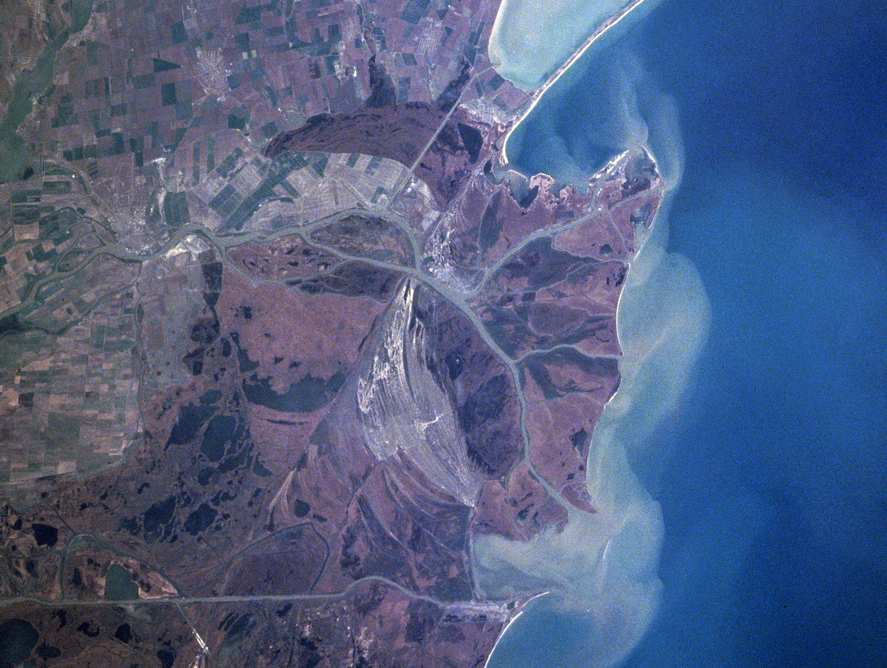


Formation, geography and hydrology
The delta evolved through sediment deposition delivered by the Danube over thousands of years, producing distinct distributary channels and many islands. Principal arms such as Chilia, Sulina and Sfântu Gheorghe distribute water and sediments and shape wetlands that range from freshwater marshes to brackish lagoons. Seasonal floods, the river's sediment load, wind and waves continually modify the shoreline and interior habitats, while human works such as canals, embankments and navigation channels influence hydrology and sediment flows.
Biodiversity and habitats
The mosaic of reedbeds (dominated locally by common reed), shallows, permanent lakes and flooded meadows supports high biodiversity. The delta is internationally important for waterbirds and hosts large colonies of pelicans and herons, numerous species of ducks and waders, and important fish communities that historically included several sturgeon species. The mix of freshwater and brackish environments also sustains diverse aquatic plants, invertebrates and mammals adapted to wetland conditions.
Human communities, economy and culture
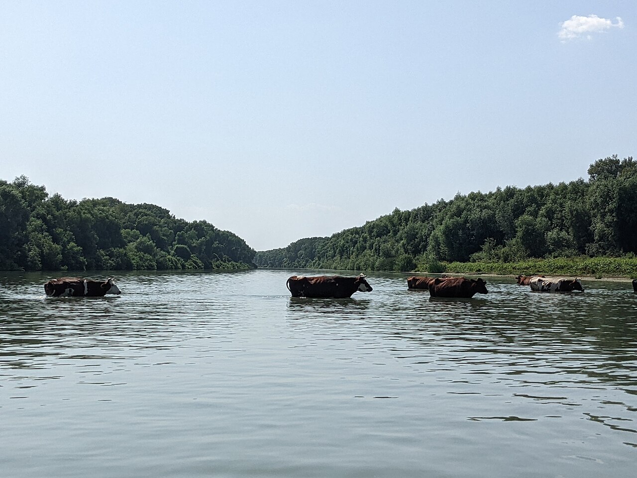
People have inhabited the delta for centuries, developing livelihoods based on fishing, reed cutting, livestock grazing and small-scale agriculture. Settlements such as Tulcea serve as regional service centres and gateways for research and tourism. Traditional cultural groups, including Lipovans and other local communities, maintain distinct languages, crafts and fishing practices that shape the region's social fabric.
Protection, management and international recognition
Large areas of the delta are subject to conservation designations. The Danube Delta was declared a biosphere reserve under UNESCO's Man and the Biosphere Programme in 1979, and portions also benefit from World Heritage and Ramsar recognitions that highlight their global ecological value. Effective management requires cross-border cooperation between Romanian and Ukrainian authorities, coordination of river basin measures upstream (river data and policies), and integration of scientific monitoring and local livelihoods.
Threats and conservation challenges
The delta faces multiple pressures: altered sediment supply due to upstream dams and river regulation, pollution from agricultural runoff and industrial sources, habitat change from invasive species and intensified navigation, and the long-term risks of sea level rise and climate change. Conservation responses include protected-area zoning, sustainable fisheries management, habitat restoration, pollution control measures and international agreements. Research and monitoring programs help guide adaptive management and assess trends in species and habitat condition.
Research, tourism and sustainable use
The Danube Delta is a focus for ecological research, environmental education and low-impact ecotourism. Guided boat trips, birdwatching and community-based activities provide income while promoting conservation awareness. Scientific studies document hydrological processes, habitat dynamics and species populations, informing management plans and restoration efforts documented in regional and international delta studies and the broader European environmental context.
- Major channels: Chilia, Sulina, Sfântu Gheorghe
- International recognitions: UNESCO biosphere reserve, World Heritage and Ramsar designations for key sectors
- Key concerns: sediment balance, pollution, invasive species, navigation impacts, sea level rise
For authoritative information, consult national reserve authorities and international conservation organizations: river basin and hydrology sources (Danube data), dedicated delta research, the European environmental context, official pages for Romania and Ukraine, and UNESCO materials on the biosphere reserve (MAB documentation).
Landscape
The Danube is the most important receiving watercourse in South-Eastern Europe and the collecting artery for the large rivers of the Eastern Alps (Inn, Drava), the Carpathians (Tisza) and the Eastern Dinarides (Sava). The Danube Delta Biosphere Reserve is located in the estuary of the Danube into the Black Sea and forms a refuge for a variety of plants and animals.
More than half of the total area of the reserve of 5800 km² comprises the area commonly referred to as the Danube Delta (3510 km²), while the remaining area is divided between the upstream Danube floodplains between Isaccea and Tulcea (102 km²), the Razim-Sinoie lagoon complex (1145 km²), a narrow strip in the Black Sea (1030 km²) down to a depth line of 20 m, and the area lying on the Danube between the island of Cotul Pisicii and Isaccea (13 km²). Hereby, the reserve in the southeastern part of Romania with an area of 3446 km² covers Tulcea and Constanța counties, and a 732 km² area in the south of Ukraine in Odessa oblast. Between Romania and Ukraine, the Danube River forms the 54 km long natural border. There are no official border crossings in this part of the border, the nearest crossings being in Galați and Brăila.
The reserve is integrated into the historical landscape of Dobruja. The mostly hilly surrounding region can be physiographically divided into the following areas:
The hinterland is predominantly marked by Paleozoic and Mesozoic soil formations. Its northern part has the highest elevations in the region, with altitudes of 180-467 meters above the zero level of the Black Sea sea level. The southern part of Dobruja consists of limestone plateaus about 100-200 meters above sea level, covered by loess soils. In total, 60 percent of the land area of Dobruja does not rise above 100 meters in altitude. In the inner area of Dobruja, the terrain flattens from north to south to highs around 300 meters. The predominant soil-forming rock is schistose. The eastern area along the coast is dominated by the extensive delta area of the Danube and its numerous lagoons. The low flat plain is 0.52 m above the mean sea level of the Black Sea and has a mean rise in general gradient of 0.006 m/km. The maximum difference in elevation is 15 m, which results from the highest point (+12.4 m) in the dunes near Letea and the lake bottom (-3 m) in the marine part. 20.5% of the delta area is below the sea level of the Black Sea, the remaining 79.5% is above it. Of the area above sea level, 54.6% is between 0 and 1 m in elevation, and 18.2% is between 1 and 2 m in elevation. In total, 93% of the delta lies within a hypsometry of 0-3 m.
From the hydromorphological point of view, the reserve is divided into:
Areas from the time before the formation of the delta
These areas are located in the historic landscape of Budshak, north of the Chilia Arm. The loess deposits of this area were eroded by water and deposited as the base of the Câmpul Chiliei and Stipoc sandbanks. They account for 2.4 percent of the area of the delta.
Sandbanks on river arms or by the sea
The river sandbanks are located along the margins of the main Danube branches and forks. The accretion and height of the sandbanks decreases towards the sea. Sea currents are primarily responsible for the formation of the sea sandbanks (also grind) running parallel to the sea coast, which formed natural sea dams from alluvial Danube sediments and increased in size in the course of time due to further deposition in the sea. The larger sandbanks deposited as a series of high dunes with intervening dune cross valleys.
River courses and canals
At the beginning of the delta west of Tulcea the mean flow of the Danube is 7320 m³/s. The differences between low water (2000 m³/s) and high water (24,000 m³/s) are considerable.
The northern Chilia Arm is the largest of the three Danube arms, with a length of 116 km. At the junction in Ismajil, the Tulcea Arm separates from the Chilia Arm, after which the Chilia Arm still carries 67 percent of the total water volume of the Danube via about 25 mouths to the Black Sea. Carried gravel, sand and silt, together with organic remains, are deposited in its own delta of about 2,430 km². Two fifths of this area lies on Ukrainian territory.
The Sulina arm runs in a straight line from west to east and carries only about 13 percent of the total river water after the junction, but it is the most important Danube arm for navigation. Between 1858 and 1902 it was regulated and its streambed deepened. By straightening its pronounced bends, the originally 84 km long waterway was shortened to 62 km. Regular dredging and maintenance work takes place to this day. The water depth reaches at least 23 feet = 7.32 metres, allowing for the traffic of medium tonnage maritime vessels.
About 20 percent of the water volume enters the sea through the 70 km long Sfântu Gheorghe arm, which forms the northern border of the Dobruja Highlands (Romanian Podișul Dobrogei) as far as Murighiol. The arm flows through the southernmost and most scenic part of the Danube Delta. In its vicinity, traces of human intervention are least visible. This area is sparsely populated; however, the flora and fauna are rich.
The area between the Chilia and Sulina arms is called Letea; between the Sulina and Sfântu Gheorghe arms is the Caraorman area; between the Sfântu Gheorghe arm and the Razim and Dranov lakes is the Dranov area.
The network of numerous tributaries, several smaller rivers, canals and side channels crisscross the plain and determine the movement of water through and around the delta. These waterways expand in many cases into lakes and form, among other things, the Razim-Sinoie lagoon complex
Lakes
Most of the lakes in the reserve are river limans, marine limans or brackish water lagoons. The long and deep Jalpuch and Kotlabuch lakes are limans on the Ukrainian side of the delta.
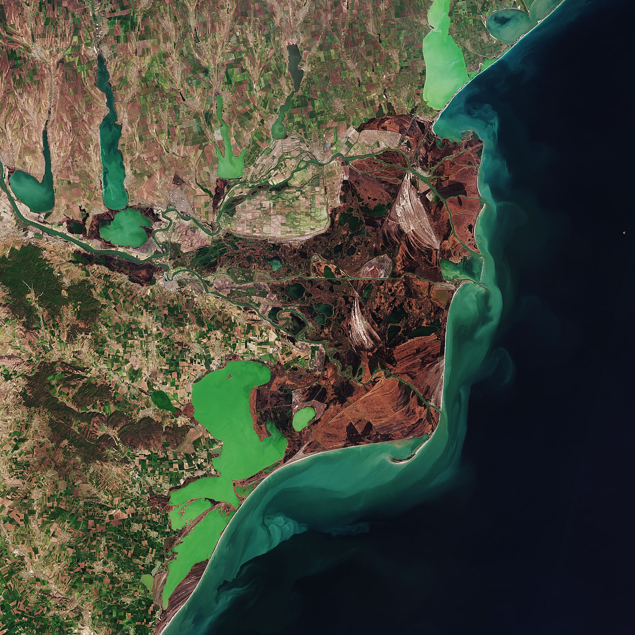
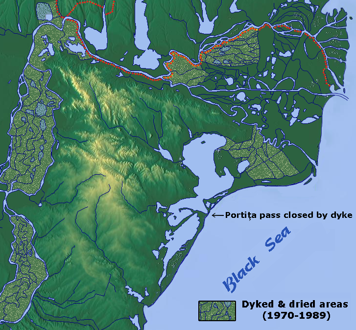
Lake Razim and Lake Sinoie south of the delta proper are brackish water lagoons. To the west and south the lakes border the Dobruja plateau and to the north the marshy area of the Sfântu Gheorghe arm. The eastern side is bordered by a series of low sandbanks. Lake Razim covers an area of about 870 km² and together with the other lakes forms a contiguous complex of 1,145 km². The lake, which has a depth of up to three metres in some places, was originally connected to the Black Sea at Portița (German: Türchen), but is now separated from it by a dyke. The dike is occasionally battered by violent storms. The Razim-Sinoie lagoon complex has 75 to 80 percent of its area permanently under water. The Sfântu Gheorghe arm feeds Lake Razim through the Dranov and Dunavăț channels. Lake Golovița and Lake Sălcioara border it to the south; Lake Smeika and Lake Sinoie follow, Lake Babadag lies to the west, Lake Calica to the north and Lake Dranov to the east.
From 1980 onwards, in communist Romania, many of the lakes in the area around Pardina and Sireasa were drained for intensive agricultural use. This reduced the lake area from 313 km² (9.28 percent of the delta area) to 258 km² (7.28 percent of the delta area). The larger lakes there include Lake Dranov (21.7 km²), Lake Gorgova (13.8 km²), Lake Roșu (14.5 km²), and Lake Lumina (13.7 km²). Before 1980, 668 lakes existed in the Romanian part of the reserve, after which drainage projects reduced their number to 479.
Swamps
87 percent of the delta consists of marshland; the rest is alluvial soil. The delta forms the largest wetland in Europe. The marshes lie between -0.5 and 1 m above the water level and surround the lakes in the delta's depressions. In early summer, the volume of incoming water in the Danube swells due to melt water from the mountains and floods the marshes. The wide estuary area between the estuary arms has a high reed population. Driven by the current, floating reed islands move through the marshy area, which is subject to constant change. The waters are enclosed by natural dams. The drainage projects of the 1980s also drained many of the Delta's swamps and bogs.
Origin
The Danube Delta was formed more than 10,000 years ago from a bay. At that time, the sea level at this point was between 50 and 60 meters below its present height. This stage indicated the formation of an "initial belt" corresponding to today's Letea Forest, Caraorman Forest and Crasnicol, which eventually led to the containment of the bay. Further deposition of billions of tons of alluvium formed the present delta. The Danube flows at mean high water with over 6000 cubic meters of water per second at Ceatalul Chiliei, where the river divides into two arms, carrying about 80 million tons of alluvial material per year. In combination with currents and waves, a labyrinth of channels, lakes and reeds was formed.
It was not until the end of the Little Ice Age that sand began to accumulate in the bay where the Danube flows into the Black Sea. From the mountain slopes of the Alps and Carpathians, debris and fine mud washed into the Danube since then. The coarse debris was already deposited in the flowing upper parts of the river course. The fine mud was transported into the lower Danube and finally into the Black Sea. The sea currents did not distribute the mud evenly in the sea, but accumulated it in the sea bay. A network of watercourses developed on the surface of these accumulations of sand and mud, some of which were repeatedly clogged by sand or reed islands and silted up, while others were recreated by floods, constantly changing the nature of the delta. Only the three major estuaries of the Danube have remained virtually unchanged since their canalization and straightening. From the late 19th century onwards, the delta was calmed; dikes protect large areas from flooding, and the fortification of the banks prevents the meanders from migrating. The increase in shipping initiated the development of ports.
The Sfântu Gheorghe arm is the oldest Danube arm and was the first arm to form its own delta. Parallel to the coastline, especially in the area of the Sfântu Gheorghe arm, several dune belts arranged in echelons line up, indicating older coastlines. With about 80 million tons of suspended sediment per year, its delta is currently growing further into the sea.
The Sulina arm developed in the sediments of the Sfântu Gheorghe arm, taking over an ever increasing inflow of sediments, forming its own delta. It is the shortest of the three arms and is currently not growing. Due to the construction of concrete walls extending far into the sea to secure the transport routes, suspended sediments are now carried out of the delta and no longer serve to build up the coastline. Numerous stillwaters in the delta are cut off from the sediment supply and are gradually silting up.
The port of Chilia Veche on the Chilia Arm was still five kilometres from the sea in the 15th century, today it is about 30 kilometres. Along this highly sedimentary arm, the coastline is currently advancing by four to five metres per year, mainly to the east of Wylkowe. Sediments that reach the sea through the Chilia Arm are carried along by the ocean current and are deposited further north around the Jibrieni Formation.
The Pleistocene rias of the Jalpuch and Kotlabuch lakes were separated from the open sea in the Holocene by the deposits of the Danube. These river limans were formed from the ancient confluences of Gârlița, Oltina, Dunăreni, Baciu, and the marine limans of Corbu, Siutghiol, Tașaul by former river mouths. Lake Razim and the neighbouring Sinoie Lagoon are spits formed by sedimentation in the former sea bays.
Climate
The Danube Delta has a continental climate with maritime moderation. Low precipitation and high sunshine duration are characteristic. The average rainfall is 457.2 millimetres per year and the average annual temperature is 11 °C, although extreme fluctuations are not uncommon. The dry climate favours desertification and prevents the development of forests.
The temperature extremes measured so far were -23.6 °C on 9 February 1929 and +37.5 °C on 20 August 1946. In Tulcea the thermometer rises above +30 °C for about 100 days a year. In Sulina there are on average 80 warm days a year. Between May and October the average temperature is +19.0 °C and the sun shines about 300 hours a month.
Rain often falls as downpours, which are short-lived. Most precipitation falls in June and the least in February and March. In the drought year 1942, the annual rainfall in Sulina was only 134.4 millimeters.
The wind blows almost constantly; the number of windless days in the course of a year is between 25 and 30. The prevailing wind direction is northeast. Crivăț called strong and cold northeast winds can reach high speeds due to the low refraction through mountains and forest.
| Average temperature (monthly average/yearly average) | |||||||||||||
| Month | Jan | Feb | Mar | Apr | May | Jun | Jul | Aug | Sep | Oct | Nov | Dec | annual |
| Tulcea | −1,8° | −0,2° | 4,2° | 10,3° | 16,2° | 19,9° | 22,2° | 21,1° | 17,4° | 12,6° | 6,2° | 1,8° | 10,8° |
| Sulina | −0,7° | −0,2° | 4,1° | 9,6° | 15,8° | 20,1° | 22,5° | 21,8° | 17,9° | 12,7° | 6,8° | 2,1° | 11,1° |
| Precipitation (monthly average/annual average in mm) | |||||||||||||
| Month | Jan | Feb | Mar | Apr | May | Jun | Jul | Aug | Sep | Oct | Nov | Dec | annual |
| Tulcea | 35,5 | 26,4 | 30,8 | 35,7 | 39,4 | 50,2 | 46,9 | 44,5 | 37,7 | 32,0 | 29,4 | 35,0 | 443,0 |
| Sulina | 24,2 | 21,0 | 21,1 | 21,6 | 34,2 | 45,5 | 34,5 | 40,8 | 26,4 | 33,6 | 27,2 | 28,9 | 359,0 |


Related articles
Author
AlegsaOnline.com Danube Delta — Europe's second-largest river delta Leandro Alegsa
URL: https://en.alegsaonline.com/art/25457
Sources
- whc.unesco.org : Danube Delta - UNESCO World Heritage Centre
- unesco.org : "Danube Delta"