Czechoslovakia: history, structure and legacy (1918–1992)
Overview of Czechoslovakia from its 1918 formation to the peaceful 1993 split, covering territory, political changes, key events, and its cultural and economic legacy.
Overview
Czechoslovakia was a Central European state created in 1918 from lands of the defunct Austria-Hungary. Located in Central Europe, it brought together the historic Czech lands (Bohemia, Moravia and Silesia) and Slovakia into a single multinational republic. The country existed in several constitutional and political forms until it dissolved peacefully at the end of 1992; on 1 January 1993 two independent countries — the Czech Republic and Slovakia — began separate statehood.
Image gallery
10 Images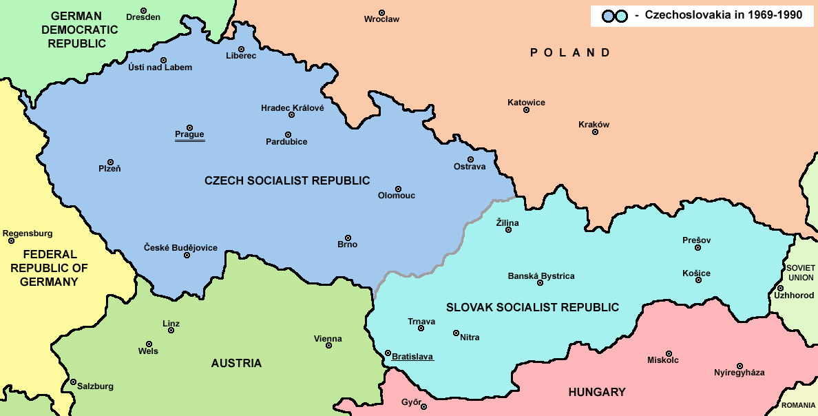


Territory and makeup
Geographically the state included the industrialized Czech core and the more rural, mountainous Slovak territories. Between 1918 and 1938 it also nominally encompassed peripheral regions such as Subcarpathian Ruthenia (often called Zakarpattia) which had a substantial Ukrainian/Rusyn population. The country was ethnically diverse, with significant German, Hungarian and other minority communities alongside Czechs and Slovaks, a factor that influenced politics throughout its existence.
Major historical phases
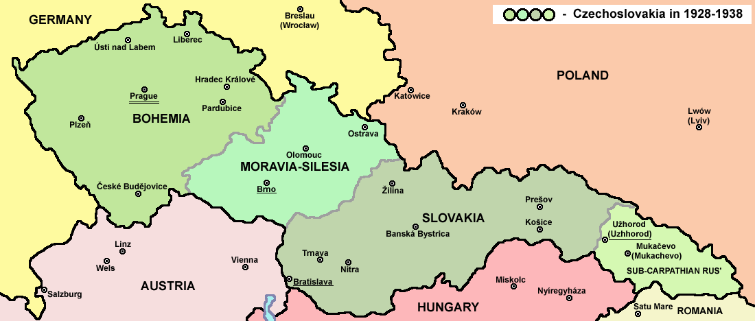
In the interwar years Czechoslovakia established itself as a democratic republic. In 1938–39 the rise of Nazi Germany led to the loss of the borderlands: the Sudetenland was annexed and the remaining Czech lands were organized as the German-controlled protectorate of Bohemia and Moravia. Slovakia became a separate, nominally independent state during the war. After World War II the country was reconstituted, though its eastern borderlands underwent changes and Zakarpattia was transferred away.
- 1918: foundation after the collapse of Austria-Hungary.
- 1938–39: territorial losses and wartime occupation by Germany.
- 1948: communist takeover; creation of the Czechoslovak Socialist Republic.
- 1968: Prague Spring reform movement under Alexander Dubcek and subsequent invasion by Warsaw Pact forces.
- 1989: Velvet Revolution and transition to democracy; 1993: peaceful division into successor states.
Political and economic life
After 1948 Czechoslovakia became a communist state aligned with the Soviet Union, a member of the Warsaw Pact and integrated into the planned-economy structures of the Eastern Bloc. Despite the constraints of the system, it remained one of the more industrially developed countries in that group. The 1968 attempts to reform state socialism sought a "socialism with a human face," but were ended by the invasion of Warsaw Pact troops. Political liberalization returned after the popular events of 1989.
Legacy and importance
Czechoslovakia left a notable cultural, intellectual and economic legacy. Its universities, manufacturing base and legal traditions influenced both successor states. The peaceful manner of its dissolution — sometimes called the Velvet Divorce — is often cited as an example of consensual separation. Contemporary Czechia and Slovakia maintain close links while pursuing independent policies within European and transatlantic institutions.
For further reading and detailed timelines see national archives and specialist histories; introductory resources can be found through historical summaries and academic overviews (regional guides, archival collections, and specialized studies on topics such as Prague Spring, Velvet Revolution, and biographical works on figures like Alexander Dubcek).
See also: the wartime changes involving Sudetenland and the protectorate of Bohemia and Moravia, wartime and postwar transfers of Zakarpattia, and the modern identities of the Ukrainian and Slovak communities within the region. Comparative studies often place Czechoslovakia among the more advanced economies of the Eastern Bloc and highlight its role in Cold War politics through alliances like the Warsaw Pact.
Other useful entry points include short timelines, lists of key legal changes, and surveys of cultural production (literature, film and science) that flourished under different regimes. For contemporary nation-state information consult sources addressing the successor states: the Czech Republic and Slovakia.
Name
→ Main article: Country name of Czechoslovakia
Czechoslovakia had several official country names. These were changed several times for ideological reasons. While the provisional constitution of 1918 used the names Czecho-Slovak Republic or Czecho-Slovak State, the constitution of 1920 established the name Czechoslovak Republic (Československá republika) without hyphen. In October 1938, after the Munich Agreement, the name was changed to Czecho-Slovak Republic.
After 1945, the old name Czechoslovak Republic was reverted to, which was retained even after the February coup of 1948. In 1960, the name was changed to Czechoslovak Socialist Republic (Československá socialistická republika). After the fall of the regime in 1989, the name was briefly changed to Czechoslovak Federal Republic, and finally to Czech and Slovak Federal Republic in 1990. The dispute between Czech and Slovak politicians in the early 1990s over hyphenated or non-hyphenated spelling has become known as the Dash War.
Geography
Czechoslovakia consisted of the Czech, Slovak and until 1946 the Carpatho-Ukrainian part of the country (Podkarpatská Rus, Karpatoukraine).
The Czech part was formed from the lands of Bohemia, Moravia and Silesia. This in turn consisted of the former Austrian Silesia and the previously Prussian area around Hulchin, but without a strip of territory east of Teschen, which fell to Poland after the Polish-Czechoslovak border war, the so-called Olsagebiet.
The character of the landscape in the different parts of the country was very different. The western area was part of the north-central European uplands.
Czechoslovakia had borders with Austria, Hungary, Ukraine (from 1991, before 1945-1991 with the Soviet Union), Romania (until 1946), Poland and Germany (or 1949-1990 with the German Democratic Republic and the Federal Republic of Germany).
The borders of the Czechoslovak state were still undetermined when it declared independence in 1918. It was not until the Treaties of Saint-Germain in 1919 that the borders of Czechoslovakia were fixed for the time being. Austria still had to cede two small areas of Lower Austria separately in 1920. After the Treaty of Trianon in 1920, the Carpathian Ukraine was annexed to the new state and the border with Hungary was established. In 1920, Germany had to cede the Hultschiner Ländchen (Czech: Hlučínsko) under the Treaty of Versailles. In 1919 a border war broke out with Poland over the disputed Olsa region, which Czechoslovakia won in 1920. The area of Czechoslovakia was then 140,446 km² by 1920. With the Kingdom of Romania, in the course of the Treaty of Sèvres, there was a minor exchange of territory in Carpathian Ukraine (1921); in this exchange, a territory located on the border with the Slovakian part of the country was exchanged for a territory located further east. The new state thus had an area of 140,800 km² from 1921 to 1938, making it about three and a half times the size of Switzerland and, at 820 km long, almost as long as Italy. At its widest point the country measured 250 km and at its narrowest only 80 km.
As a result of the Munich Agreement in 1938, Czechoslovakia lost about 14% of its national territory. Hungary received 11,882 km² of southern Slovakia through the First Vienna Arbitration Award in 1938. Poland acquired the town of Teschen with its surroundings (about 906 km²) and two smaller border areas in northern Slovakia, the regions of Spiš and Orava (226 km²). The total area of territorial losses was 41,442 km² (about a quarter of the national territory). In 1939, Czechoslovakia had only 99,348 km² left.
After the Second World War, the republic was restored to its 1937 borders; near Bratislava, the so-called Bratislava bridgehead was enlarged in 1946 and a 4,400 km² strip of land in the east was acquired at the expense of Hungary. The territory controlled by Czechoslovakia now covered an area of 144,846 km² and represented for the country the largest expansion in its history. In 1946, Carpathian Ukraine was ceded to the Soviet Union under a 1945 agreement. The national territory lost 12,777 km² and until 1992 still comprised 127,876 km².
Czechoslovakia had many raw materials on its territory and possessed the largest uranium deposits in Europe. In the Czech part of the country there was hard coal and lignite, kaolin, clay, graphite, limestone, quartz sand, and uranium at Dolní Rožínka and in Pilsen. Deposits of copper and manganese ore were found in the Slovak Ore Mountains. Lead and zinc ore were found at Kutná Hora and Příbram. Small amounts of mercury, antimony and tin were still present in the Ore Mountains. There were larger reserves of salt in Slovakia and petroleum in the south and in Carpathian Ukraine. Graphite was found near ?eské Bud?jovice and kaolin near Pilsen and Karlovy Vary.
Czechoslovakia was located in the temperate climate zone, with strong differences between the individual parts of the country. The warmest and driest areas were in the south. In the mountains and especially in Carpathian Ukraine, low temperatures prevailed almost all year round. In Vígľaš-Pstruša, now in Slovakia, -41 °C was reached on February 11, 1929. In the flat areas, precipitation was generally concentrated in summer.
Spring usually began in early April and was mild and quite sunny. In the relatively cool summer, cool air came from Eastern Europe. Autumn set in at the end of August. Winter was very cold and dry in Czechoslovakia and the longest season.

Related articles
Author
AlegsaOnline.com Czechoslovakia: history, structure and legacy (1918–1992) Leandro Alegsa
URL: https://en.alegsaonline.com/art/24984
Sources
- avalon.law.yale.edu : "THE COVENANT OF THE LEAGUE OF NATIONS"
- pitt.edu : "Czecho-Slovakia or Czechoslovakia"