
Cuxhaven, Germany — North Sea port and seaside resort
Cuxhaven is a coastal town in Lower Saxony at the mouth of the Elbe. A ferry and tourism hub, it combines seaport activity, Wadden Sea nature, and popular beach quarters like Duhnen and Döse.
Cuxhaven is an independent town in northern Lower Saxony and the administrative seat of the district often referred to as Cuxhaven. It sits where the Elbe River meets the North Sea, making it both a maritime gateway and a long-established seaside resort on Germany's coast. The urban area stretches roughly 14 km east–west and 7 km north–south and is home to about 52,000 residents. Its beaches and dunes, including the popular quarters of Duhnen, Döse and Sahlenburg, attract holidaymakers in summer and offer mudflat walks in the cooler months.
Image gallery
8 Images




Geography and natural setting
Located at the northernmost point of Lower Saxony, Cuxhaven occupies a low-lying coastal landscape characterized by tidal flats, salt marshes and sandy shorelines. The adjacent Wadden Sea is a dynamic intertidal region recognized for its ecological importance; nearby protected areas form part of a larger conservation network. The town's seaward position has shaped local climate, economies and recreational life.
History and development
Originally a fishing and pilot community, Cuxhaven expanded in the 19th century as seaside bathing and health tourism became popular. Its harbour facilities grew to serve shipping on the Elbe and to connect inland waterways with North Sea trade routes. Over time the town developed infrastructure for ferries and passenger services to islands and offshore outposts, while retaining features of a coastal resort.
Economy, transport and maritime functions
Cuxhaven's economy combines port operations, fisheries, tourism and services. The harbour handles cargo and serves as a departure point for passenger boats. Regular excursions and ferry services operate to offshore destinations such as Neuwerk and Heligoland, linking the town with island communities and visitor routes. The maritime character is visible in commercial shipping, marine research and seasonal leisure boating.
Tourism, culture and landmarks
Visitors come for broad beaches, seaside promenades and regional seafood. Notable landmarks include the wooden beacon known as the Kugelbake, historic piers such as the Alte Liebe and maritime museums that document local navigation and coastal life. Guided mudflat hiking on the Wadden Sea, birdwatching and cycling along coastal trails are common activities. Seasonal festivals and spa facilities also contribute to the town's appeal.
Practical information and distinctions
- Administrative role: seat of the surrounding district (Cuxhaven district).
- Location: mouth of the Elbe flowing into the North Sea.
- Regional context: part of Lower Saxony within Germany.
Whether approached as a working port, a nature gateway to the Wadden Sea or a seaside resort, Cuxhaven combines maritime industry and coastal recreation in a distinctive North Sea setting.

Geographical location and climate
Cuxhaven is located at the northern tip of Lower Saxony and is surrounded by water on two sides. The northernmost point of Lower Saxony is located in the district of Döse. This geographical location gives the town a special attraction for tourism, but also causes it special problems with regard to the economic connection to the hinterland.
The highest elevation in the town area is the Altenwalder Höhe (37.5 m above sea level); formerly the site of Altenwalder Burg on an old Saxon burial ground.
Due to the peripheral location and the historical affiliation of the city to Hamburg, two economic focal points developed: fishing and tourism. In addition to the core city, Cuxhaven comprises a number of incorporated villages spread over a comparatively large area. While the port developed from the old centre of Cuxhaven around the pilot quarter and Ritzebüttel Castle, the resorts of Döse, Duhnen and Sahlenburg, which are situated to the west of this centre and belong to the urban area, are the focus of tourism.
Cuxhaven has a humid climate with warm summers (Köppen-Geiger: Cfb). Due to the maritime location of the city, the summers are very mild in comparison to Central Europe; for example, the daily maximum temperature in August averaged only about 21.6 °C from 1991 to 2020.
| Cuxhaven | ||||||||||||||||||||||||||||||||||||||||||||||||
| Climate diagram | ||||||||||||||||||||||||||||||||||||||||||||||||
| ||||||||||||||||||||||||||||||||||||||||||||||||
| Climate data Cuxhaven
Source: DWD, September values: 1991-2016 and 2018-2020, precipitation in August: 1991-2018 and 2020, otherwise: 1991-2020. | |||||||||||||||||||||||||||||||||||||||||||||||||||||||||||||||||||||||||||||||||||||||||||||||||||||||||||||||||||||||||||||||||||||||||||||||||||||||||||||||||||||||||||||||||||||||||||||||||||||||||||||||
| Cuxhaven | ||||||||||||||||||||||||||||||||||||||||||||||||
| Climate diagram | ||||||||||||||||||||||||||||||||||||||||||||||||
| ||||||||||||||||||||||||||||||||||||||||||||||||
| Climate data Cuxhaven
Source: DWD, water temperature: reference period 1988-1995, otherwise: reference period 1961-1990 | |||||||||||||||||||||||||||||||||||||||||||||||||||||||||||||||||||||||||||||||||||||||||||||||||||||||||||||||||||||||||||||||||||||||||||||||||||||||||||||||||||||||||||||||||||||||||||||||||||||||||||||||||||||||||||||||||||||||||||||||||||||||||||||||||||||||||||||||||||||||||||||||||||||||||
At the end of the 20th and beginning of the 21st century, summers in Cuxhaven have become significantly warmer; if the daily maximum temperature in August was still about 20.1 °C on average for the years 1961-1990, it was about 21.6 °C for the reference period 1991-2020. Winters have also become milder; if the mean daily maximum temperature for the years 1961-1990 was about 3.0 °C in January, it was 4.5 °C for the period 1991-2020.
City breakdown
|
|
Neighboring communities
| Neuwerk district | ||
|
| Otterndorf | |
| Wurster North Sea coast | Neuenkirchen |


Politics
Elections
The last local elections resulted in the following distribution of seats immediately after the election:
| Local election | TheCuxhavener | Green | Unaffiliated | Total | |||||
| 11 September 2016 | 14 | 13 | 4 | 1 | 4 | 1 | - – | 3 | 40 seats |
| 11 September 2011 | 14 | 15 | 7 | 1 | 4 | 1 | - – | - – | 42 seats |
| September 10, 2006 | 16 | 14 | 3 | 3 | 3 | 1 | - – | - – | 40 seats |
| 09 September 2001 | 19 | 16 | 2 | 2 | 2 | - – | 1 | - – | 42 seats |
City Council
The council of the city of Cuxhaven consists of 40 members. This is the fixed number for a municipality with a population of between 40,001 and 50,000. The council is elected at municipal elections for five years at a time. The current term of office began on 1 November 2016 and ends on 31 October 2021.
The Lord Mayor is also entitled to vote in the Council.
Lord Mayor
→ Main article: List of mayors and lord mayors of Cuxhaven
Since 1 November 2019, Uwe Santjer (SPD) has been the full-time Lord Mayor, succeeding Ulrich Getsch. He won an absolute majority of 51% in the first round of voting against Harald Zahrte and Hans-Jürgen Wendt on 26 May 2019.
Coat of arms and flag
Since 20 December 1912, the town of Cuxhaven has officially had a town coat of arms. The Hamburg senator Emil Mumssen as lord of the manor of Ritzebüttel approved the coat of arms on 28 January 1913.
|
| Blazon: "The coat of arms of the city shows the black ball beacon, whose foot is washed by blue water, in a golden shield covered with a mural crown with three battlements." |
| Coat of arms reason: Klemens Stadler means to this in his book:
|
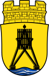
The flag of the city of Cuxhaven is white-red striped with the city coat of arms in the middle. The colors of the city are white-red.
Twinning
- France
 Vannes, France, since 1963
 - United Kingdom
 Penzance, United Kingdom, since 1967
 - Iceland
 Hafnarfjörður, Iceland, since 1988
 - Germany
 Binz and Sassnitz on Rügen, Germany, since 1990
Since 1987 there was a town twinning with Nuuk, the capital of Greenland. Due to a territorial and administrative reform in Nuuk, it was terminated in March 2011.
Friendships between cities


Related articles
Author
AlegsaOnline.com Cuxhaven, Germany — North Sea port and seaside resort Leandro Alegsa
URL: https://en.alegsaonline.com/art/24821
Sources
- destatis.de : "Alle politisch selbständigen Gemeinden mit ausgewählten Merkmalen am 31.12.2018 (4. Quartal)" · web.archive.org
- www1.nls.niedersachsen.de : Landesbetrieb für Statistik und Kommunikationstechnologie Niedersachsen, 102 Bevölkerung - Basis Zensus 2011, Stand 31. Dezember 2015 (Tabelle K1020014)