Croatia
![]()
Hrvatska is a redirect to this article. For other meanings, see Hrvatska (disambiguation).
Template:Infobox State/Maintenance/NAME-German
Croatia (Croatian ![]() [xř̩ʋaːtskaː], officially Republic of Croatia, Croatian
[xř̩ʋaːtskaː], officially Republic of Croatia, Croatian![]() Republika ) is a state in the transition zone between Central and Southeastern Europe. Croatia is a member of the European Union, NATO, the World Trade Organization, the OSCE and the United Nations. The capital and largest city is Zagreb, with other major cities including Split, Rijeka and Osijek.
Republika ) is a state in the transition zone between Central and Southeastern Europe. Croatia is a member of the European Union, NATO, the World Trade Organization, the OSCE and the United Nations. The capital and largest city is Zagreb, with other major cities including Split, Rijeka and Osijek.
The country lies east of the Adriatic Sea and partly in the southwest of the Pannonian Plain. It borders Slovenia to the northwest, Hungary to the north, Serbia to the northeast, Bosnia and Herzegovina to the east and Montenegro to the southeast. The territory of the former Republic of Ragusa (Dubrovačka Republika), which today constitutes the southernmost part of the state, has no direct land connection to the rest of the national territory, as the few kilometres wide sea access of Bosnia and Herzegovina lies in between; the area around Dubrovnik thus forms the only exclave of the country.
Geography
Croatia's land area is approximately 56,500 square kilometres, about twice the size of Brandenburg. The land area includes part of the Dinarides and the Pannonian Plain.
The country lies in the transition zone between Central or East-Central Europe and Southeastern Europe. The greater part of Croatia (except Slavonia and the area around Zagreb north of the Sava River) is generally assigned geographically to the Balkan Peninsula or Southeastern Europe. In 2005, the Standing Committee on Geographical Names recommended that Croatia be assigned to Central Europe on the basis of a cultural-geographical Central European term. For some Croats, the assignment to Central Europe is a means of demarcation from the negatively connoted "crisis region" of the Balkans. The Croatian areas along the Adriatic coast are also partly assigned to Southern Europe.
The smallest distance between Italy and Croatia is 20 kilometres (separated by a small strip of Slovenian land), while the southernmost Croatian peninsula, Prevlaka, is 69 kilometres from Albania.
Borders
The territory of Croatia covers 88,073 square kilometres, of which 56,594 are terrestrial and 31,479 maritime. The territory of Croatia is divided into a continental northern part and a long coastal strip, at whose narrow junction southwest of Zagreb the territory narrows extremely. The southernmost part of the coastal area (the region around Dubrovnik up to the border with Montenegro) is separated from the rest of Croatia by the municipality of Neum, which belongs to Bosnia and Herzegovina, over a width of about 7.5 kilometres. In order to be able to bypass the foreign territory in the form of this Neum corridor in the future, the Pelješac Bridge is being built at a cost of EUR 420 million.
The total length of Croatia's land borders is 2197 kilometres. Of this, the border with Slovenia is 670 kilometres, the border with Hungary 329 kilometres, the border with Bosnia and Herzegovina 932 kilometres, the border with Serbia 241 kilometres and the border with Montenegro 25 kilometres. In the northern Adriatic, the maritime border with Slovenia is disputed (see: International conflicts of the successor states of Yugoslavia). The length of the Adriatic coastline (mainland) is 1778 kilometres (with islands 6176).
Climate
The climate in the interior and northeast of Croatia is mainly continental. The average daily maximum temperature in the lowlands is around 28 °C in summer and around 5 °C in winter. The average low temperature in winter is below 0 °C. The annual precipitation is about 750 millimeters.
The climate on the Adriatic coast, on the other hand, is much more humid and a Mediterranean climate prevails. Summers are therefore mostly sunny and dry with average maximum temperatures around 30 °C, while winters are rainy and mild (average daily highs around 10 °C). In the northern part of the coast, night frosts occur frequently in winter, while in the southern part this is the case only on a few days. The annual precipitation directly on the coast is somewhat higher than inland, at around 1000 millimetres. The annual precipitation in the Croatian part of the Dinaric mountains is between 1000 and 2000 millimetres.
A special weather phenomenon are the occasional cold fall winds Bora in the coastal region, which are among the strongest in the world.
Landscape zones
Croatia can be divided into three landscape zones according to relief and climate.
The Pannonian Plain
The Pannonian Plain consists mainly of lowlands, interrupted by some low mountain ranges, and is drained by the Sava and Drava rivers and their tributaries to the Danube. This part of the country has a temperate continental climate. This landscape zone can be divided into Northern Croatia and Slavonia. Northern Croatia comprises the Central European area from the Kupa River to the Hungarian border: the lowlands along the Sava and Kupa Rivers around the cities of Zagreb, Karlovac and Sisak, which today form the demographic and economic centre of the country, the mountainous area of Zagorje north of the capital Zagreb, and Međimurje in the northernmost corner of the country between the Drava and Mura Rivers. Slavonia is the lowlands along the rivers Sava and Drava to the Danube in the east. Baranja (north of the lower reaches of the Drava) and Western Syrmia (Zapadni Srijem) (the eastern tip of Croatia between the Danube and the lower Sava) are often included in this region.
The Dinaric mountain region
The Dinaric mountain region (also called Central Croatia or Croatian Hill Country) is characterised by low and some high mountains, which form the watershed between the Danube and the Adriatic, with some valleys being completely without drainage. A mountain climate prevails here. This landscape zone includes the mountainous area of Gorski kotar between Rijeka and Karlovac, the high valleys of Lika and Krbava between the Velebit mountain range running along the coast and the border area with western Bosnia, as well as part of the Dalmatian hinterland (Zagora, Biokovo mountains).
The Adriatic coastal region
The Adriatic coastal region consists largely of karstified areas. It is characterized by Mediterranean influences. The width of the coastal strip varies greatly. While in some places (below the Velebit and Biokovo mountains) it is only a few kilometres wide, in other places it extends further inland. However, the majority of rivers flowing into the Adriatic in Croatia are relatively short; only the catchment area of the Neretva, coming from Bosnia and Herzegovina, extends further inland. The Adriatic coastal region can be subdivided from north to south into the historical regions:
- Istria - the peninsula in the northwest of the Croatian coast.
- Hrvatsko Primorje (Croatian coastal land) around Rijeka and Senj with the islands of the Kvarner Bay
- Dalmatia - the rugged Adriatic coast southwards from about Zadar including the offshore islands and the mountainous hinterland with historically important cities such as Dubrovnik (Ragusa) and Split.
Largest islands
→ Main article: Croatian islands
Croatia has a total of 1246 islands, 47 of which are permanently inhabited.
| No. | Island | Area [km²] | Inhabitants |
| 1. | Cres | 405,78 | 3.184 |
| 2. | Krk | 405,78 | 17.860 |
| 3. | Brač | 395,44 | 14.031 |
| 4. | Hvar | 299,66 | 11.103 |
| 5. | Pag | 284,56 | 8.398 |
| 6. | Korčula | 276,03 | 16.182 |
| 7. | Dugi Otok | 114,44 | 1.772 |
| 8. | Mljet | 100,41 | 1.111 |
| 9. | Rab | 90,84 | 9.480 |
| 10. | Vis | 90,26 | 3.617 |
| 11. | Lošinj | 74,68 | 7.771 |
| 12. | Pašman | 60,11 | 2.711 |
| 13. | Šolta | 58,17 | 1.479 |
| 14. | Ugljan | 51,04 | 6.182 |
| 15. | Lastovo | 40,82 | 835 |
Highest mountains
| No. | Name | Height [m] | Mountain |
| 1. | Dinara (Sinjal) | 1831 | in the Dinara mountains |
| 2. | Sveti Jure (St. George) | 1761 | in the Biokovo massif |
| 3. | Vagansky Vrh | 1751 | in the Velebit mountains |
| 4. | Ozeblin | 1657 | in the Plješevica mountains |
| 5. | Bjelolasica-Kula | 1533 | in the Velika-Kapela mountains |
| 6. | Risnjak | 1528 | in the Risnjak mountains |
| 7. | Svilaja | 1508 | in the Svilaja mountains |
| 8. | Snježnik | 1506 | in the Snježnik mountains |
Waters
According to the FAO analysis, Croatia is one of the 30 most water-rich countries in the world and ranks third in Europe with a total of 32,818 cubic metres of renewable water reserves per capita and year. The World Water Development Report 2005 of the United Nations speaks of 23,890 cubic metres of annually renewable water reserves per capita and year. Croatia is located in the Blue Heart of Europe.
Croatia is one of the few states with organized water governance. As early as 1891, the Sabor passed a Water Law Act of the Kingdom of Croatia and Slavonia, which provides legal regulations for water bodies, river beds, the coast, water use, regulation of water flows, as well as flood protection, water protection, water protection associations and much more. According to an ADAC survey from 2006, the Croatian Adriatic was
![]()
Parts of this article appear to be out of date since 2006.
Please help to research and insert the missing information.
Wikipedia:WikiProject Events/Past/2006
the cleanest part of the Mediterranean.
In Yale University's Environmental Sustainability Index, which looks at the state of environmental protection in a country as a whole, Croatia ranked 19th in the world in 2005.
Lakes
The four largest lakes in Croatia are:
| No. | Name | Area | Note |
| 1. | Vransko jezero | 30.7 km² | |
| 2. | Dubravsko jezero | 17.1 km² | |
| 3. | Lake Peruća | 13.0 km² | on the Cetina River, Croat. Peručko jezero |
| 4. | Prokljansko jezero | 11.1 km² |
The most famous lakes are the Plitvice Lakes.
Rivers
The majority of rivers drain into the Black Sea (Danube, Sava, Drava, Mura, Kupa and Una), the rest into the Adriatic Sea (Zrmanja, Krka, Cetina and Neretva). The rivers in the north are very polluted, the most polluted being the Sava between Zagreb and Sisak.
The longest rivers flowing through Croatia are the Sava (562 kilometres) and the Drava (505 kilometres). These rivers largely form the borders with Bosnia-Herzegovina and Hungary respectively. Both rivers flow into the Danube, the Sava being the most water-rich, the Drava the fourth most water-rich tributary of the Danube. The Danube separates Croatia from the Serbian province of Vojvodina. The Croatian part of the Danube is 188 kilometres long, and Croatia borders almost exclusively on the right bank of the Danube.
The Kupa (Slovenian: Kolpa, 269 kilometres) forms a large part of the border with Slovenia. It flows into the Sava in Sisak, which is navigable from there. Other rivers are the Korana, Krapina, Lonja, Mur and the Vuka.
The rivers from the Dinarides to the Adriatic are relatively short, only the Neretva, which rises in Herzegovina, represents a significant river to the Adriatic.
See also: List of rivers in Croatia
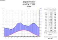
Climate diagram
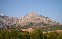
Section of the Biokovo Mountains, part of the Dinaric Alps
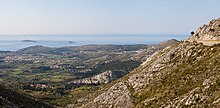
Coastal region in Dubrovnik-Neretva County
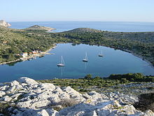
Kornati Archipelago
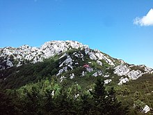
The Risnjak forms at the same time a Croatian national park
53 beaches and 26 marinas are marked with a Blue Flag in Croatia 2021
National and nature parks
→ Main article: List of national parks and nature parks in Croatia
Croatia has eight national parks and eleven protected nature parks. A total of 450 areas, including 79 special reserves (botanical, geomorphological, ornithological, marine and forest reserves) are protected. A total of 5846 square kilometres, or ten per cent of Croatia's mainland area, is protected; if protected waters are included, the total is 6129 square kilometres. Croatia has shares in the European Green Belt.
National Parks
| No. | Name | Description |
| 1. | Plitvice Lakes National Park | Croatian Plitvička jezera (waterfalls), national park since 1949, UNESCO World Natural Heritage since 1979, among other things the setting for the Winnetou movies |
| 2. | National Park Paklenica | climbing possibilities, karst caves, national park since 1949 |
| 3. | Risnjak National Park | in the mountainous region of Gorski kotar near Rijeka, national park since 1953 |
| 4. | Mljet National Park | Island in southern Dalmatia, national park since 1960 |
| 5. | Kornati National Park | Croatian Kornati (island archipelago), protected since 1964 |
| 6. | Krka National Park | near Šibenik (waterfalls), national park since 1985, among other things the scene of the Winnetou films |
| 7. | Northern Velebit National Park | Varied karst phenomena, richness of flora and fauna in a very small area, national park since 1999 |
| 8. | Brijuni National Park | also called Brijuni, off Istria, former Tito summer residence, small safari park |
Nature Parks
| No. | Name | Description |
| 1. | Kopački rit Nature Park | Wetland on the Danube |
| 2. | Papuk Nature Park | in Central Slavonia |
| 3. | Lonjsko polje Nature Park | Wetland on the Sava River |
| 4. | Nature Park Medvednica | the "local mountain" of Zagreb |
| 5. | Nature Park Žumberak-Samoborsko gorje | west of Zagreb |
| 6. | Učka Nature Park | Mountain range near Rijeka, separates Istria from the rest of the mainland |
| 7. | Velebit Nature Park | includes the entire mountain range (northern Velebit and Paklenica particularly protected) |
| 8. | Nature Park Vransko jezero | in the Zagora |
| 9. | Nature Park Telašćica | in the Kornati Islands |
| 10. | Biokovo Nature Park | Mountain range in southern Dalmatia |
| 11. | Lastovo Nature Park | Island in South Dalmatia |
Geomorphological phenomena
| No. | Name | Description |
| 1. | Crveno jezero | "Red Lake" near Imotski |
| 2. | Modra špilja | the "Blue Grotto" on the island of Biševo near Vis |
| 3. | Vransko Jezero | the "Vrana Lake" between Zadar and Šibenik |
| 4. | Vela Draga | a canyon in the Učka Nature Park |
| 5. | Bijele and Samarske stijene | a nature reserve in the Kapela mountain massif |
| 6. | Rožanski kuk and Hajdučki kuk | a nature reserve in the Velebit mountain massif |
| 7. | Zmajevo oko | the "Dragon Eye Lake" near Rogoznica in Dalmatia |
.jpg)
The Blue Grotto of Biševo
.jpg)
Plitvice Lakes National Park (UNESCO World Heritage Site)
Search within the encyclopedia