
Coordinate system
A coordinate system assigns numbers to points so their positions are uniquely specified. Covers Cartesian, polar, spherical and other systems, uses, history, and how coordinates transform between frames.
Overview
A coordinate system is a rule for assigning one or more numbers to each point in a space so that the point can be identified uniquely. In the simplest plane examples the assignment is an ordered pair of values; for three-dimensional space a triplet is used. Coordinates are numerical values (often called scalars) measured with respect to an origin and one or more reference axes or directions.
Image gallery
2 Images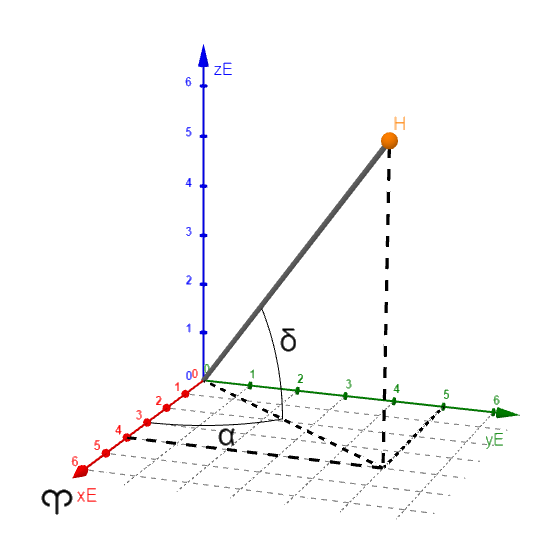

Parts and characteristics
Every coordinate system has an origin, a set of axes or coordinate surfaces, and a convention for ordering the values. Systems may be orthogonal (axes at right angles), orthonormal (axes at right angles and unit length), or skew (non‑perpendicular). Orientation (right‑handed or left‑handed) and units are part of the definition, and coordinates depend on the chosen reference frame.
Common types
- Cartesian (rectangular): points by (x,y) in the plane or (x,y,z) in space.
- Polar and cylindrical: plane points by (r,θ); in 3D cylindrical adds z.
- Spherical: typically given by radius and two angles (ρ,θ,φ) for three dimensions.
- Geodetic and map projections: coordinates on Earth’s surface using latitude/longitude or projected x,y grids.
History and development
The systematic use of coordinates for geometry is usually credited to René Descartes and Pierre de Fermat in the 17th century, which enabled algebraic methods to describe curves and shapes. Since then many specialized systems and conventions have been developed for navigation, astronomy, engineering and modern physics.
Applications and examples
Coordinate systems underpin navigation, surveying, computer graphics, robotics and scientific modeling. For example, a plane point can be written as (x,y) in a Cartesian frame or as (r,θ) in a two-dimensional polar system, with the familiar relations x = r cos θ and y = r sin θ. In three dimensions one chooses between Cartesian, cylindrical or spherical coordinates depending on symmetry.
Transformations and distinctions
Changing from one coordinate system to another requires transformation formulas and may introduce singularities (for example θ is undefined at r=0). In advanced geometry the term "coordinate chart" refers to local parameterizations on curved spaces. It is useful to distinguish between a coordinate system (the numerical labelling) and a reference frame (the physical axes and origin). For higher‑dimensional problems, additional numbers are required—see more dimensions.
Understanding coordinate choices and transformations is essential for modeling, computation and interpreting measurements in science and engineering.

|
| a | b | c | d | e | f | g | h |
|
| 8 |
|
|
|
|
|
|
|
| 8 |
| 7 |
|
|
|
|
|
|
|
| 7 |
| 6 |
|
|
|
|
|
|
|
| 6 |
| 5 |
|
|
|
|
|
|
|
| 5 |
| 4 |
|
|
|
|
|
|
|
| 4 |
| 3 |
|
|
|
|
|
|
|
| 3 |
| 2 |
|
|
|
|
|
|
|
| 2 |
| 1 |
|
|
|
|
|
|
|
| 1 |
|
| a | b | c | d | e | f | g | h |
|


The squares of the chessboard are designated with a pair of numbers and letters.
Affine coordinate system
→ Main article: Affine coordinates
Selecting three points  not on a straight line in the Euclidean plane, the two vectors are
  linearly independent. With the point
  as origin, the location vector
  of any point written like this

and assign to the point number pair  as affine coordinates with respect to the base points
If the vectors form an orthonormal basis, Cartesian coordinates result. In this case, for a point  the sets of points
  and are
  Straight lines that intersect orthogonally.
If the basis vectors are not orthogonal (see picture), we speak of oblique coordinates.
Accordingly, affine coordinates are explained for higher dimensions.
Defining coordinates in this way is possible for any n-dimensional affine space over a body, so is not limited to a Euclidean space.
Since the 3-dimensional space plays an important role in practice, there are certain agreements for the introduction of coordinates, e.g. the legal system.


Non-affine coordinate systems
In the plane
Since for calculations of lengths and angles it is advantageous if the curves or intersect orthogonally, one is interested in curve systems which intersect orthogonally. Because, then it is easy to specify a local Cartesian coordinate system at each point (see below).
The simplest non-linear orthogonal curve system consists of the rays in a point and the associated concentric circles. Thus one obtains the polar coordinates. Note: They are  defined only for points For the radius coordinate, The angular range consists only of the half-open interval
  .
.
Elliptical coordinates use perpendicularly intersecting systems of confocal ellipses and hyperbolas. These coordinates are not defined for the focal points and the points between them.
In space
The spatial coordinates corresponding to the polar coordinates are the
Cylinder coordinates. They are defined only for points outside the cylinder axis. and the
Spherical coordinates. Restrictions of the definition ranges and points, to which spherical coordinates are assigned, apply also here.
The (plane) elliptical coordinates correspond to the ellipsoid coordinates. The orthogonal surface system used here consists of confocal ellipsoids, single-shell and double-shell hyperboloids.
Furthermore there are the ellipsoidal coordinates, which are used for the description of points of a rotation ellipsoid (earth).
On surfaces
Parameter representations of surfaces can be seen as coordinate systems of these surfaces. E.g. the parameter representation of a plane, the usual parameter representation of a spherical surface with geographical longitude and latitude or the paramer representation of an ellipsoid.
Other curvilinear coordinate systems
Further examples and applications of coordinate systems can be found in the article curvilinear coordinates.
Local coordinate systems
If are  plane curvilinear orthogonal coordinates (polar coordinates, elliptic coordinates,...) and if one determines in a point
 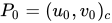 the tangent directions of the curves and and normalizes these, then one receives local basis vectors, which one can use for a local Cartesian coordinate system.
In polar coordinates, one vector points in the direction of the radius and the other in the direction of the tangent of the circle through . Here, the local system can be thought to have arisen from the global system by displacement and suitable rotation.
In space, one determines the tangent vectors to the curves passing through a point 
 ,
,  and
and  and normalizes them. See (in the picture) the example spherical coordinates.


Related articles
Author
AlegsaOnline.com Coordinate system Leandro Alegsa
URL: https://en.alegsaonline.com/art/22912