Aalen, Baden-Württemberg
Aalen is a medium-sized town in the German state of Baden-Württemberg, seat of the Ostalbkreis. It blends Roman archaeological sites, industrial development and a university in the eastern Swabian Jura region.
Overview
Aalen is a town in Baden-Württemberg in Germany, and serves as the administrative center of the Ostalbkreis district. Located on the eastern edge of the Swabian Jura (Schwäbische Alb) and along the Kocher valley, it functions as a regional hub for commerce, education and local government. The urban area combines older town neighborhoods with modern residential and industrial districts.
Image gallery
10 Images


Characteristics and institutions
Aalen mixes historic sites with contemporary institutions. It hosts a University of Applied Sciences that focuses on engineering and applied research, public services, cultural venues and museums. The town is known locally for its archaeological heritage connected to the Roman frontier, civic architecture, and outdoor recreation opportunities in nearby hills.
History and archaeology
Human settlement in the Aalen area dates back to antiquity. Roman military installations and traces of the Limes Germanicus — the frontier system that once marked the edge of the Roman Empire — are important features of the local past. Remains of fortifications and finds from that period are displayed in local museums and inform the town’s historical profile. Over the medieval and early modern eras Aalen developed into a market and administrative place before industrialization shaped its modern economy.
Economy, transport and culture
The local economy combines small and medium manufacturing enterprises, service industries and research-linked activities tied to higher education. Aalen is linked to regional transport networks by road and rail, providing connections to larger urban centers. Cultural life includes museums focused on regional history and archaeology, public festivals, and access to hiking and nature on the Swabian Jura.
Notable facts
- Important Roman archaeological sites and a museum that interpret the Limes frontier.
- Seat of the Ostalbkreis district and a regional center for education and industry.
- Proximity to natural landscapes of the Swabian Jura offers recreational opportunities.


Geography
Geographical position
Aalen is located in the valley of the upper Kocher at its outlet from the eastern Swabian Alb, which rises to the south and east of the city, in the so-called Aalen Bay. North of the city is the landscape of the Ellwanger Berge. To the northwest lies the Welland.
The urban area of Aalen has a share in the natural areas of the Eastern Alb Foothills (western urban area) and the Swabian-Franconian Forest Mountains (north and northwest), both of which belong to the Swabian Keuper-Lias Land, as well as the Albuch (southwest) and the Härtsfeld (east), both of which represent a sub-area of the Swabian Alb.
The Kocher flows from Oberkochen in the south into the city area, flows in a northerly direction through the district of Unterkochen, then the core city - where the Aal flows in - and the district of Wasseralfingen, and leaves it in the north in the direction of Hüttlingen. The rivers Rems (near Essingen, west of Aalen) and Jagst (near Unterschneidheim, east of Aalen) also rise near Aalen, both of which, like the Kocher, are tributaries of the Neckar.
The market place in the city centre lies at 430 m above sea level. The lowest point in the city area is the Lein near Rodamsdörfle at 375 m above sea level, the highest point is the summit of the Grünenberg near Himmlingen at 733 m above sea level.
City breakdown
The urban area of Aalen consists of the core city and the municipalities incorporated between 1938 (Unterrombach) and 1975 (Wasseralfingen) (see section Incorporations). The municipalities incorporated only during the most recent territorial reform in the 1970s are also called city districts and are at the same time localities in the sense of the Baden-Württemberg municipal code. They each have a local council, which is elected in the municipal elections and whose chairman is the head of the locality.
The core city of Aalen and the incorporated communities include a large number of mostly spatially separated suburbs. Most of them have a long independent history; others were created as new building areas, which then received their own names, but often no fixed boundaries. In detail, the following suburbs exist:
| Village | Crest1 | Area in km² | Residents | Suburbs |
| Aalen (core city) |
| 20,858 | 26.851 | Himmlingen, Hirschhof |
| Dewangen |
| 16,533 | 03.256 | Aushof, Bernhardsdorf, Bronnenhäusle, Bubenrain, Degenhof, Dreherhof, Faulherrnhof, Freudenhöfle, Gobühl, Großdölzerhof, Haldenhaus, Hüttenhöfe, Kleindölzerhof, Kohlhöfle, Langenhalde, Lusthof, Neuhof, Rauburr, Reichenbach, Riegelhof, Rodamsdörfle, Rotsold, Schafhof, Schultheißenhöfle, Streithöfle, Tannenhof, Trübenreute |
| Ebnat |
| 21,161 | 03.306 | Affalterwang, Diepertsbuch, Niesitz |
| Fachsenfeld |
| 3,950 | 03.600 | Bodenbach, Frankeneich, Hangendenbuch, Himmlingsweiler, Mühlhäusle, Sanzenbach, Scherrenmühle, Spitzschafhaus, Steinfurt, Waiblingen |
| Hofen |
| 12,583 | 02.011 | Attenhofen, Fürsitz, Goldshöfe, Heimatsmühle, Kellerhaus, Oberalfingen, Wagenrain |
| Unterkochen |
| 21,444 | 05.073 | Birkhof, Glashütte, Klause, Neukochen, Neuziegelhütte, Pulvermühle, Stefansweilermühle |
| Unterrombach/Hofherrnweiler |
| 9,757 | 09.163 | Hahnenberg, Hammerstadt, Hofherrnweiler, Lauchhof, Mädle, Mantelhof, Neßlau, Oberrombach, Pompelhof, Rauental, Sandberg, Sauerbachhof, Schwalbenhof, Sofienhof, Vogelsang |
| Waldhausen |
| 24,375 | 02.430 | Arlesberg, Bernlohe, Beuren, Brastelburg, Geiselwang, Hohenberg, Neubau, Simmisweiler |
| Wasseralfingen |
| 15,965 | 11.912 | Affalterried, Brausenried, Erzhäusle, Heisenberg, Mäderhof, Onatsfeld, Rötenberg, Röthardt, Treppach, Weidenfeld |
1 Coat of arms of the former municipality
See also: List of towns in the Ostalbkreis district
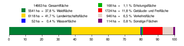
The maximum extension of the Aalen city area is 18 km in north-south and 25 km in east-west direction. As of 31 December 2012, the urban area has an area of 14,662.6 hectares. Of this, 41.8% (6,127.4 ha) is agricultural land and 37.8% (5,540.8 ha) is forest land. 11.7% (1,715.9 ha) is building or open space, 6.5% (946.1 ha) is transport land. The share of sports, recreation and green areas is 1.1 % (166.7 ha), water areas 0.4 % (51.8 ha), operational areas 0.2 % (34.3 ha), other areas 0.5 % (79.6 ha).
Floor space allocation
According to data from the State Statistical Office, as of 2014.
Neighboring communities
The following towns and municipalities border the city of Aalen (clockwise, starting in the south; in brackets the distance of the respective city centre to the city centre of Aalen, as the crow flies):
Oberkochen (6 km), Essingen (6 km), Heuchlingen (11 km), Abtsgmünd (9 km), Neuler (10 km), Hüttlingen (6 km), Rainau (10 km), Westhausen (9 km), Lauchheim (12 km), Bopfingen (20 km) and Neresheim (20 km, all Ostalbkreis) as well as Heidenheim an der Brenz (18 km) and Königsbronn (10 km, both Landkreis Heidenheim).
Spatial planning
Aalen forms a middle centre within the region of Ostwürttemberg, which has not designated a regional centre of its own. The central area of Aalen includes the towns and municipalities in the central and eastern part of the Ostalbkreis: Abtsgmünd, Bopfingen, Essingen, Hüttlingen, Kirchheim am Ries, Lauchheim, Neresheim, Oberkochen, Riesbürg and Westhausen. There are links with the neighbouring centre of Nördlingen in Bavaria, about 30 kilometres to the east.
Geology
The urban area of Aalen covers all three lithostratigraphic groups of the South German Jurassic: the south and the Flexner Massif lie on the White Jurassic, the inner city on the Brown Jurassic, and part of Wasseralfen on the Black Jurassic. For this reason, the city of Aalen advertises itself as the "Mecca of geologists".
The majority of the Aalen city area lies on the Opalinus Clay Formation of the Unteraalenian, named after the city of Aalen. On the Sandberg, the Schnaitberg and the Schradenberg (all in the west of Aalen) the iron sandstone formation of the Oberaalenian emerges. On the remaining hills in the city area there are mainly sands and gravels (Goldshöfer Sande) as well as residual gravels. The old town of Aalen as well as other areas along the course of the Kocher (including Wasseralfingen) are completely founded on a valley filling of alluvial loam and river gravel.
The largest parts of Dewangen and Fachsenfeld lie on the Jurensismergel, Posidonienschiefer, Amaltheenton, Numismalismergel and Obtususton formations, which are successive to the north and belong to the Jurassic and are rich in fossils. The final layer is the Knollenmergel layer, which already belongs to the Keuper.
Iron ore was mined on the Braunenberg until 1939 (see section Tiefer Stollen).
Climate
Since the city area of Aalen extends over the Albvorland, the Voralb, the Albuch and over the Härtsfeld and overcomes a total of 355 meters of altitude difference between the lowest and highest point, the climate varies from district to district.
The monitoring station from which the following data are taken is located between the core city of Aalen and Wasseralfingen at approximately 48° 51′ 2″ N, 10° 5′ 44″ E48.850555555610.0955555556 and has been providing readings since 1991.
The number of sunshine hours is about 1,800 per year, which corresponds to an average daily sunshine duration of about 4.93 hours. This puts Aalen above the national average (1,550 hours per year). But also with the number of rainy days per year the region is with 167 above the German average of 138 days per year and with an annual precipitation of about 807 mm also in the moderate average of Baden-Württemberg. The annual average temperature is 9.9 °C. Here, too, Aalen is above the national average of 8.2 °C and the state average of 8.1 °C for Baden-Württemberg.
Detailed climate diagrams
| Monthly average temperatures and precipitation for Aalen
Source: Meteorological variables in Aalen 1991-2014, City of Aalen and Weather Aalen, holidaycheck.de | |||||||||||||||||||||||||||||||||||||||||||||||||||||||||||||||||||||||||||||||||||||||||||||||||||||||||||||||||||||||||||||||||||||||||||||||||||||||||||||||||||||||||||||||||||||||||||||||||||||||||||||||||||||||||||||||||||||||||||||


History
City history
First settlement
Flint tools and traces of human resting places from the Middle Stone Age between the 8th and 5th millennium B.C. were found at several sites on the valley edge of the Kocher and Jagst rivers. The core of a hilltop settlement on the 650 by 350 metre high plateau Schloßbaufeld behind the Unterkochen Kocherburg is attributed to the Bronze Age. In the Wasseralfinger forest Appenwang, in Goldshöfe and Ebnat grave mounds of the Hallstatt period are known. The Celts left gold and silver coins which have been found in Aalen and Wasseralfingen. They fortified the settlement on the castle building field with sectional ramparts and a stone wall. Near Wasseralfingen-Heisenberg lies, superficially no longer recognizable, a Celtic square enclosure.
Roman times
After the abandonment of the Alblimes, the area of the town of Aalen became part of the Roman Empire around the year 150 AD and lay directly on the then newly founded Upper Germanic-Raetian Limes. The Romans built a fort for the cavalry unit Ala II Flavia Milliaria, the remains of which are known as Fort Aalen. It was located west of today's city centre below the Schillerhöhe and, with over a thousand horsemen and almost as many grooms, was the largest camp of auxiliary troops on the entire Upper Germanic-Raetian Limes. Civilian settlements adjoined it to the south and east. Around 260, the Romans abandoned the fort when they withdrew their border against unoccupied Germania behind the rivers Rhine and Danube. Subsequently, the Alamanni took over the region. According to coin finds, which can be assigned to the late 3rd and 4th centuries, the camp settlement initially continued to exist. There is no evidence of a continuous settlement beyond this between the Roman period and the Middle Ages.
City foundation
Finds of Alamanni graves dating from the 7th century are considered by archaeologists to be the nucleus of the village of Aalen. Roman stones were used in the north and west walls of St. John's Church, which is located directly in front of the east gate of the Roman fort; the present building probably dates from the 9th century.
In the Middle Ages, a place that today belongs to Aalen was first mentioned in 839, when Emperor Ludwig the Pious allowed the monastery of Fulda to exchange goods in the hamlet of Hammerstadt (Hamarstat). Aalen itself was first mentioned in a property register of Ellwangen Monastery in 1136 as the village of Alon and a local nobleman named Konrad von Aalen. This noble family probably had its ancestral castle on the Burgstall south of the core town and was probably first in the service of Ellwangen Monastery, later of the Staufers, then of the Oettinger. In honour of Emperor Friedrich Barbarossa, who according to a story from the 16th century is said to have held a court meeting here, a Barbarossa fountain was erected below the Burgstall. In 1426, a member of the family was last attested in connection with Aalen. Medieval documents indicate that the town of Aalen was founded by the Staufers between 1241 and 1246 on a different site from the village of Aalen, and that the latter was destroyed in the town war in 1388. Later, the Counts of Oettingen were attested city lords, which is first documented for 1340. They pledged the town in 1358 or 1359 for a sum of money to Count Eberhard II and thus to the county of Württemberg.
Time as an imperial city
proclamation as imperial city
Emperor Charles IV captured the town of Aalen in the imperial war against Württemberg after a siege without a fight. On December 3, 1360, he declared it an imperial city (often erroneously: free imperial city), which it retained until 1803. In 1377, Aalen became a member of the Swabian League of Cities, and from 1500 of the Swabian Imperial Circle. In 1385 the term civitas appeared for the first time in the town seal. In 1398 the town was granted the right to hold markets, and in 1401 it was granted court jurisdiction. However, Aalen was not able to acquire a large territory: Apart from the actual town, only a few nearby hamlets belonged to the "territory".
The oldest preserved view of the town dates from 1528. It was drawn as the basis of a legal dispute of the town against the Counts of Oettingen before the Imperial Chamber Court in Speyer and shows Aalen surrounded by walls, towers and double moats. The course of the moats, between which lay a ring wall, can be recognized by the present-day street names Nördlicher, Östlicher, Südlicher and Westlicher Stadtgraben. The wall, which was about 6 metres high, was 1518 paces (990 metres) long, and the walled city area covered 5.3 hectares. At the time of its foundation, the town had two gates: the Obere or Ellwanger Tor in the east and the Martinstor in the south. Due to frequent flooding, the Martinstor was walled up in the 14th century and replaced by the Untere or Gmünder Tor, built shortly before 1400 in the west. Later, several smaller side gates were built. The central street market took place on the Wettegasse, now called Marktplatz, and Reichsstätter Straße and thus ran, as was customary at the time, from one town gate to the other, although in Aalen it was bent in an L-shape between the southern (Martinstor) and eastern (Ellwanger) gates.
Around 1500, the cemetery was moved from the town church to St. John's Church. In 1514, an assembly formed from the citizenry met for the first time with the Twenty-four.
Reformation
Commissioned by Duke Ludwig of Württemberg, Jakob Andreae, a university professor from Tübingen and chancellor of the university, arrived in Aalen on June 28, 1575, almost thirty years after Martin Luther's death. His sermon the next day convinced the mayor, city council, and citizens to introduce the Reformation in Aalen; he stayed in town for four weeks to help with the introduction. This brought enormous changes; for example, the Catholic priest was forbidden to hold mass and preach by the city council. Mayor Kaspar Voss (1512-1589) signed the Lutheran Formula of Concord of 1577 on behalf of the town council in 1579. After the victories of the imperial forces at the beginning of the Thirty Years' War, the prince provostry of Ellwangen, which was still patroness of Aalen, was able to temporarily reassert Catholicism in 1628. However, after the successes of the Protestant Union in 1632, the Protestant church regiment was restored.
Town fire 1634
In the night of September 5 to 6, 1634, two ensigns of the army of Bernhard of Saxony, which was retreating after the battle of Nördlingen and fighting for Sweden, set fire to two powder wagons in order not to leave the war material to the enemy in view of the Croatian soldiers who had already entered the city and to impede their advance. The result was a town fire, the extent of which is judged differently. According to the account from the 17th century, the church and all the buildings in the town, except for the tower of the sword, fell victim to the fire, and only nine families survived. Research by Hermann Bauer from the 19th century considers this to be inconclusive and exaggerated; however, it is undoubted that the town church and "perhaps a fairly wide circle of houses around the same" perished. The fire also destroyed the town archive with all its documents, which was housed in an annex of the town church. After the fire, marauding soldiers of the two armies roamed the town. Only after almost a hundred years the old number of inhabitants of almost 2000 was reached again.
French troops passed through Aalen in 1688 during the War of the Palatinate Succession, but without causing serious damage, as elsewhere, as well as in 1702 during the War of the Spanish Succession and in 1741 during the War of the Austrian Succession, in which imperial troops also passed through the town in 1743.
The tower of the town church collapsed in 1765, presumably because insufficient attention had been paid to statics during reconstruction after the town fire of 1634. The collapsing tower caught two of the tower keeper's children, who died of their injuries. The town church was destroyed, only the altar cross was preserved. The damage was so extensive that the church ruins had to be demolished; in the same year, work began on rebuilding the church in its present form.
On November 22, 1749, the Aalen Protocol was signed in the neutral imperial city of Aalen between the Duchy of Württemberg and the Province of Ellwangen, which was to regulate the coexistence of Protestants and Catholics in Oberkochen.
Napoleonic period
During the First Coalition War, Aalen was heavily plundered in 1796. The Second Coalition War ended in 1801 with the Peace of Lunéville, which led to the Reichsdeputationshauptschluss (Imperial Deputation Treaty) in 1803, with which most of the imperial cities were assigned to the respective neighbouring principalities. Aalen became part of the Electorate (later Kingdom) of Württemberg and was the seat of the Oberamt Aalen. During the Third Coalition War, Napoleon Bonaparte arrived in Aalen on October 6, 1805, carrying an army of 40,000 soldiers. According to the town clerk, this and the arrival of Bavarian and Austrian troops a few days later led to hardships that "cannot be described with any pen".
In 1811, the community of Unterrombach was formed from several hamlets, some of which belonged to Aalen and some to the Wöllwarth dominion. The eastern hamlets of Aalen became part of the municipality of Unterkochen.
In the age of the Napoleonic wars, the city walls were no longer militarily useful. The maintenance of walls, gates and towers had been increasingly neglected in the 18th century, so that more and more structures of the wall became dilapidated. There was no money for a general renovation, also in view of the considerable war expenses. From 1800 onwards, most of the towers were demolished, the other structures followed shortly afterwards, so that today the fortifications have almost completely disappeared.
Industrial Revolution
Before the Industrial Revolution, Aalen's economic structure was shaped by its rural environment. Many of the town's citizens worked as farmers in addition to their crafts. A common craft was that of the tanner; in the middle of the 19th century there were twelve tanneries in Aalen, with Ulm as an important sales market. Other crafts were weaving mills, which produced wool and linen products, as well as sugar bakeries and gingerbread workshops.
A first peak of industrialization was the 1840s, when three wire pencil factories and several other factories were established in Aalen. Only the connection to the railway network in 1861 with the opening of the Remsbahn from Cannstatt to Wasseralfingen brought upswing to the city, together with the royal ironworks (later Schwäbische Hüttenwerke) in Wasseralfingen the industry in Aalen flourished. The extension of the Remsbahn to Nördlingen in 1863, the opening of the Brenzbahn in 1864 and the Obere Jagstbahn in 1866 turned the Aalen railway station into a railway junction. From 1876 onwards, the cog railway of the Wasseralfingen iron and steel works was the first cog railway in Germany to connect Wasseralfingen with the Tiefer Stollen mine. In addition, from 1901 until its closure in 1972, the Härtsfeldbahn ran via Neresheim to Dillingen on the Danube. An operating workshop, the large locomotive shed, an operating office, two railway maintenance depots and a goods station with a municipal industrial railway for the development of factories in the southern town and Erlau shaped the townscape in such a way that during this time Aalen is also called a railway town by today's local historians. In 1866 the Aalen gasworks was opened and gas lighting was introduced. In 1870 the town got a modern water supply and in 1912 the first electricity lines. Finally, in 1935, the first electric street lighting was installed.
In order to counteract the housing shortage during and after the First World War, the town of Aalen built shanty towns in the Schlauch and at the Alter Turnplatz during this time. Despite the industry being paralyzed by the world economic crisis after 1929, the bathing establishment at Hirschbach was rebuilt into a modern open-air bath with an enlarged swimming area in 1931.
Nazi period
In the Reichstag election of November 6, 1932, the NSDAP did below average in Aalen; there it received 25.8 percent of the vote (compared to 33.1 percent in the Reich) and was thus only the second strongest party in Aalen behind the Centre Party, which received 26.6 percent (11.9 percent in the Reich), and ahead of the SPD with 19.8 percent (20.4 percent). By the time of the Reichstag elections on 5 March 1933, the first after Hitler's seizure of power, the picture had changed; although the NSDAP still underperformed with 34.1 percent (43.9 percent in the Reich), it was now by far the strongest party in Aalen as well. It was followed by the Centre, which received an unchanged 26.6 percent of the vote (Reich: 11.3), and by the SPD with 18.6 percent (Reich: 18.3).
At the beginning of the Nazi era, the democratically elected mayor Friedrich Schwarz remained in office until the National Socialists ousted him in 1934 and replaced him first with the chairman of the NSDAP municipal council faction and brewery owner Karl Barth as office administrator and later with the lawyer Karl Schübel. In August 1934, the NS consumer exhibition "Braune Messe" took place in Aalen.
In 1936, a riding and driving school of the military district was stationed in the town, as well as an army catering office and an army auxiliary vehicle office were established and an army auxiliary ammunition facility was accommodated.
In 1935, the incorporation of neighboring villages began. In 1934, the Oberamt Aalen was renamed Kreis Aalen and in 1938, as part of the administrative reform during the Nazi period in Württemberg, it was transferred to the administrative district of Aalen and the municipality of Unterrombach was dissolved. Most of its territory became part of Aalen, but the village of Hammerstadt became part of the municipality of Dewangen. Forst, Rauental and Vogelsang came to Essingen (from 1952, the entire former municipality of Unterrombach then belonged to Aalen, with the exception of Forst, which remained with Essingen until today).
In the municipal hospital, the deaconesses who had previously worked there were increasingly replaced by nurses of the National Socialist People's Welfare Association. In the course of the Nazi ideology of racial hygiene, about 490 people or about 200 people, depending on the source, were forcibly sterilized there.
In September 1944, the Wiesendorf concentration camp, a subcamp of the Natzweiler concentration camp in Alsace, was established in Wasseralfingen for 200 to 300 prisoners who had to perform forced labor in industrial companies in the surrounding area. By the time the camp was dissolved in February 1945, 60 prisoners had died. The camp buildings were demolished between 1946 and 1957; foundations still exist in the building at Moltkestraße 44/46. In addition, prisoners of war as well as men and women from countries occupied by Germany who had to work for the armaments industry in large companies such as the Schwäbische Hüttenwerke and the Alfing Keßler machine factory were concentrated in several work camps.
Aalen was largely spared from the fighting of the Second World War. Only in the last weeks of the war did air raids lead to the destruction or severe damage of parts of the town, the railway station and other railway facilities. A series of air raids lasting more than three weeks reached its climax on April 17, 1945, when bombers of the U.S. Air Force bombed the Army Sidecar Office stationed in Aalen and the railway facilities. Fifty-nine people were killed, over half of them buried, and over 500 were left homeless. 33 residential buildings, 12 other buildings and 2 bridges were destroyed and 163 buildings, including 2 churches, were damaged. Five days later, Aalen's National Socialist rulers were deposed by American forces.
Postwar
In 1945 Aalen fell into the American occupation zone and thus belonged to the newly founded state of Württemberg-Baden. With the foundation of Baden-Württemberg in 1952, Aalen became part of this federal state. With the district reform, which came into force on 1 January 1973, the district of Aalen became part of the Ostalbkreis. Aalen became the county seat of the new county. In 1975, the city area reached its current extent (see below).
In 1946, the population of the town of Aalen exceeded the limit of 20,000, the prerequisite for the status of Großer Kreisstadt. On 1 August 1947, Aalen was declared an immediate district town and, when the Baden-Württemberg municipal code came into force on 1 April 1956, it became a large district town.
In 1992 the Heimattage Baden-Württemberg took place in Aalen.
The city achieved greater notoriety involuntarily in 2006, when an insect allegedly 50 meters tall was discovered on a satellite image from Google Maps near Aalen. However, this later turned out to be a fringe winged insect that had gotten onto the image when the photo was scanned.
The largest urban development project since the year 2000 is the so-called "Stadtoval", a centrally located industrial wasteland to the north-east of Aalen railway station. In 2000, a construction steel company ceased operations on the approximately four-hectare site. After the site was taken over by the real estate company Aurelis in 2003, negotiations with the city council about its future use followed, and in 2010 an urban planning competition was held. This resulted in the planning of a mixed-use area with apartments for around 460 people and company offices. At the beginning of 2013, the city bought the site from Aurelis for €2.5 million, and demolition of the former factory buildings began in February 2014. Shortly afterwards, renovation work began on a former railway building on the site, which is to become the "Kulturbahnhof".
Incorporations
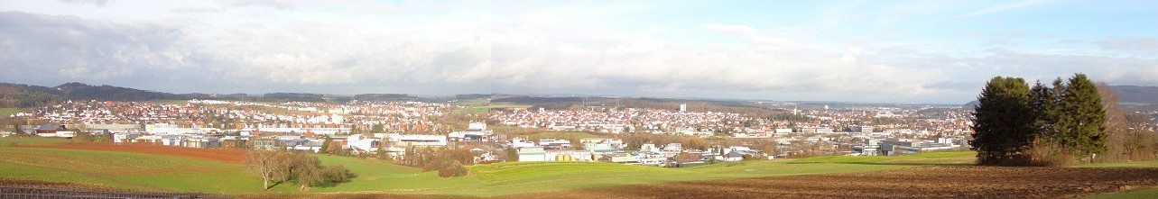
enlarge and show information about the picture
![]()
View of Aalen, seen from the thermal bath (December 2014)
Today's city of Aalen was formed on 21 June 1975 by uniting the cities of Aalen and Wasseralfingen, initially under the name of Aalen-Wasseralfingen, which, however, was already renamed the city of Aalen on 1 July 1975. The former city of Aalen had already incorporated the following municipalities:
- 1938: Unterrombach
- 1 January 1970: Waldhausen
- 1 July 1972: Ebnat
- 1 January 1973: Dewangen, Fachsenfeld (with the hamlet of Hangendenbuch, which had been transferred from Abtsgmünd in 1954) and Unterkochen. With the incorporation of Dewangen, the previous municipal area of Aalen was almost doubled.
The town of Wasseralfingen had incorporated the community of Hofen on 1 April 1972.
Population development and population structure
In the Middle Ages and early modern times, Aalen was only a small town with a few hundred inhabitants. The population grew only slowly and declined again and again due to the numerous wars, epidemics and famines. It was not until the beginning of industrialisation in the 19th century that the population growth accelerated. Whereas in 1803 only 1,932 people lived in the town, by 1905 there were already 10,442. Even after this the population continued to rise. In 1939 Aalen had 15,890 inhabitants.
Due to the influx of refugees and displaced persons from the German eastern territories after World War II, the population of the town rose to 31,814 by 1961. The merger with Wasseralfingen on 21 June 1975 brought an increase of 14,597 persons to 65,165 inhabitants. On 30 June 2005, the "official number of inhabitants" for Aalen was 67,125 according to the update of the State Statistical Office of Baden-Württemberg (only main residences and after comparison with the other state offices).
The following overview shows the population figures according to the respective territorial status. Up to 1823, these are mostly estimates, thereafter census results (¹) or official updates of the State Statistical Office. Before 1871, the number of inhabitants was determined according to non-uniform census methods. From 1871 onwards, the data refer to the "resident population", from 1925 onwards to the resident population and since 1987 to the "population at the place of principal residence".
|
|
|
¹ Census result
On 31 December 2008, Aalen had exactly 66,058 inhabitants. Among them were 33,579 women and 32,479 men. The average age of Aalen's inhabitants rose by 1.9 years from 40.5 years on 31 December 2000 to 42.4 on 31 December 2008. 6,312 people with a nationality other than German lived in the entire city area, which corresponds to a proportion of foreigners of about 9.56 percent. Of these, the largest proportion is that of Turkish citizens at 38 per cent. Due to this relatively high proportion, which, however, only corresponds to about 3.6 percent of Aalen's total population, Aalen's partnership with the southern Turkish city of Antakya came into being (see section on town twinning). The second largest proportion of foreigners in Aalen is that of Italians with 13 percent (proportion of the total population: 1.2 percent). 5 and 6 percent of the foreigners in Aalen are Serbs and Croats respectively (total population: 0.5 and 0.6 percent). 3 percent of the foreigners are Greeks (0.3 percent of the total population). The remaining 35 percent have a different nationality than those mentioned.
The number of married residents in the entire metropolitan area decreased from 32,948 on December 31, 1996 to 31,357 on December 31, 2007, whereas the number of divorced residents increased from 2,625 to 3,859 during the same period. The number of single residents also increased slightly from 25,902 to 26,268 between 1996 and 2004, and again to 26,147 by 2007. The number of widowed residents decreased from 5,036 on December 31, 1996 to 4,783 on December 31, 2007.
· 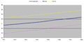
Average age of the inhabitants of Aalen
· 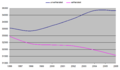
Proportion of married residents compared to unmarried residents


![Barbarossa fountain below the Aalen castle stables is based on a seal of Emperor Frederick I Barbarossa. The inscription reads: IMPERATOR FREDERIC[US] DEI GRATIA ROMANORU[M] (Eng: Frederick by the Grace of God Emperor of the Romans).](https://www.alegsaonline.com/zoom.php?image=Aalen_Barbarossabrunnen.jpg)


Related articles
Author
AlegsaOnline.com Aalen, Baden-Württemberg Leandro Alegsa
URL: https://en.alegsaonline.com/art/225
Sources
- destatis.de : "Alle politisch selbständigen Gemeinden mit ausgewählten Merkmalen am 31.12.2018 (4. Quartal)" · web.archive.org
- destatis.de : "Gemeinden in Deutschland nach Fläche, Bevölkerung und Postleitzahl am 30.09.2016"