Comoros
![]()
This article is about the state of the Comoros, for the group of islands forming this state see Archipelago of the Comoros.
Template:Infobox State/Maintenance/TRANSCRIPTION
Template:Infobox State/Maintenance/NAME-German
The Comoros (Arabic جزر القمر Juzur al-Qumur, Comorian قمر Komori, French Comores [kɔˈmɔːʀ]), officially the Union of the Comoros since 2001, form a federal island state in the Indian Ocean at the northern exit of the Strait of Mozambique between Mozambique and Madagascar. They comprise three of the four main islands of the Comoros archipelago. These are Grande Comore (Njazidja), Anjouan (Nzwani), Mohéli (Mwali) and some smaller islands. The fourth main island, Mayotte (Mahoré), is an overseas department of France and is also claimed by the Union.
The Comoros became independent from France in 1975 and since then has experienced a chequered history with coups and secessionist efforts. Its inhabitants are of mixed, predominantly East African and Arab descent and are mostly Muslims. The country's name is derived from the Arabic Juzur al-Qumur (جزر القمر), meaning "Islands of the Moon".
Geography
Nature area
The Comoros archipelago rises on a submarine ridge. All islands are of volcanic origin and have a mountainous relief. Volcanic mountains with deeply furrowed slopes, plateaus, chains of hills and mostly only narrow coastal strips characterize the landscape. The coasts of the islands are predominantly rocky and lined with coral reefs. In the center of the main island Grande Comore lies the 2361 meter high active volcano Karthala. The last major eruption occurred in 1977, when an entire village was overrun by lava. At the beginning of 2005 there was a smaller eruption, which took place without explosion or lava emission. Only ash covered a considerable part of the volcano after the eruption. At the end of May 2006, the volcano covered the capital Moroni with a cloud of dust and smoke, which led to local evacuations.
Climate
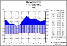
The tropical-maritime climate shows only slight temperature fluctuations throughout the year. The average temperature of the coolest months (July/August) is 22 °C, that of the warmest months (February/March) 27 °C. Between May and October there is a dry southeast trade wind, and from November to April there is a northwest monsoon that brings rain. The wettest month is January. Depending on the altitude, between 1000 and 4000 mm of annual precipitation are recorded. In the hot season, tropical cyclones often pass over the islands.
flora and fauna
The original vegetation - dense tropical rainforest with valuable wood species - has been greatly reduced and is almost only preserved at higher altitudes. Plantations and savannahs dominate the landscape today. In lowlands, coconut palms, bananas and mango trees are predominant. The coasts are partly covered by mangroves. The land fauna is relatively poor in species and shows similarities to that of Madagascar. There are rare bird and turtle species as well as a species of wet-nosed monkey, the Mongozmaki, which can only be found here. The coastal waters and coral reefs are rich in aquatic life. A speciality is the coelacanth; in 1938 a representative of this genus, which until then had only been known as a fossil, was caught off the Comoros for the first time.
See also: Nature reserves in the Comoros
Main cities
The largest cities, according to the Census, are:
- Moroni (pop. 75,000, 2017)
- Mutsamudu (pop. 23,594, 2021).
- Fomboni (pop. 17,000, 2017)
- Domoni (pop. 14,509, 2021)
- Mirontsi (pop. 12,000, 2017)
See also: List of cities in Comoros

Climate diagram Moroni/Comoros
.jpg)
View of the harbour and the Badjanani mosque in the capital Moroni
Population
As in all developing countries, the population of Comoros is quite young. 39.4% of the population was younger than 15 years in 2019. The median age in 2020 was an estimated 20.4 years. This is also due to the fertility rate of 4.1 children per woman, whereas this figure was around 7 children in the mid-1970s. Population growth was 2.2% in 2019. Anjouan is the most densely populated island in the archipelago. In 2004, 64% of the inhabitants still lived in rural areas,
The official languages are Comorian (related to Swahili), Arabic and French. The Comorians (97% of the total population) are descended from Arabs, Madagascans, Bantu, Indians, Shirasi and Indo-Melanesians. In addition, a few hundred Europeans live on the islands. Population growth and high unemployment lead to emigration, especially to Mayotte and Madagascar.
The Comoros is one of the poorest countries in the world.
Religions
See also: Christianity in the Comoros
The state religion of the country is Sunni Islam of the Shafiite school of law. About 99% of the inhabitants belong to this religion. In addition, there is a small minority of Indian Ismailis (Shia) in the Comoros, as well as a Catholic charitable missionary activity; about 1% of the population professes Christianity.
Education
After gaining independence and the withdrawal of French teachers, the education system was of poor quality with moderately trained teachers. Since the 1975 education reform, schooling has been compulsory for eight years, including the two-year Koranic school for pre-school children. The illiteracy rate is estimated at 50 %.
Health
There are considerable gaps in social welfare and health care. Malnutrition is one of the reasons for the high infant mortality rate (2004: 5.2 %). Malaria is widespread. In 2004, there were 15 doctors per 100,000 people in the country. The infant mortality rate was 52 per 1000 live births in 2019, and the child mortality rate was 68 per 1000. Life expectancy was about 64.3 years in 2019.

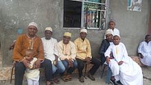
Villagers in Bangoua Kouni in the north of Grande Comore
Search within the encyclopedia