Aachen — German city of history, science and cultural heritage
Aachen is a historic German city near the borders of Belgium and the Netherlands, known for its cathedral, Charlemagne legacy, RWTH university and its role in World War II.
Overview
Aachen is a city in western Germany with a long cultural and political history. Located close to the Belgian and Dutch borders, it is part of the state of North Rhine-Westphalia and is administered within the country of Germany. Modern Aachen has around a quarter of a million residents and combines industrial, academic and touristic roles.
Image gallery
10 Images


Names and identity
The city is known by several names in different languages and traditions. In French it is Aix-la-Chapelle and in older English usage sometimes appears as Aix-la-Chapelle as well. Latin sources refer to it as Aquae Granni or Aquisgranum, while in Dutch it is called Aken. Administratively it is a city within the German federal system.
Historical significance
Aachen has ancient roots and became especially prominent in the early Middle Ages as the principal residence of Charlemagne. The cathedral built there became a symbolic coronation site for medieval German kings and an important pilgrimage destination. In modern history Aachen is also remembered for the Battle of Aachen in 1944 during World War II, where forces of the United States engaged the defending forces of Nazi Germany.
Education, economy and culture
Aachen hosts a major technical university, the Rheinisch-Westfälische Technische Hochschule (RWTH), which shapes the city's research profile and attracts students internationally. The local economy mixes engineering, manufacturing, services and tourism. Cultural heritage, festivals and museums complement academic life and contribute to a lively urban atmosphere.
Characteristics and notable features
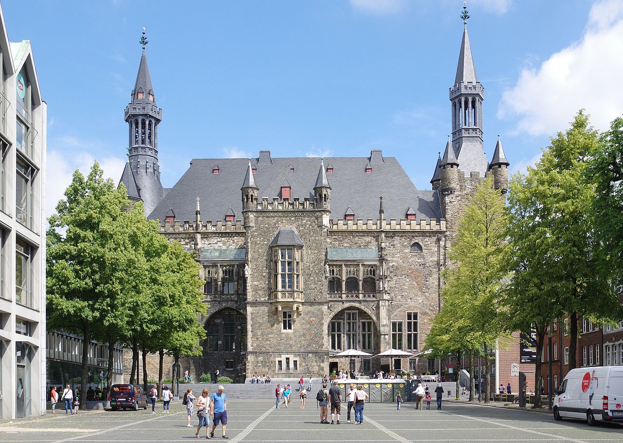
- Architectural and historic landmarks: the Aachen cathedral and remnants of medieval and Roman-era structures.
- Cross-border location: its proximity to neighboring countries influences commerce and daily life.
- Academic and technological emphasis: research institutions and technical industry cluster around the university.
- Transport and regional role: Aachen acts as a regional hub within its state and the broader Euregio area.
Aachen's combination of deep historical roots and contemporary scientific activity makes it a distinctive city in Germany. Further reading and references can be sought through regional guides and official municipal sources available online from local authorities and cultural institutions, often listed under the city's multilingual names.


Geography
Location
enlarge and show information about the picture
![]()
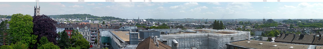
View from the Luisenhospital to Jakobskirche, Lousberg, city hall, cathedral and other characteristic buildings of the city
Aachen is located in the border region to the Netherlands and Belgium (Euregio Meuse-Rhine) on the northern edge of the Eifel and the Rhenish Slate Mountains respectively. The Eifel and the High Fens in the south, wide areas between the Lower Rhine and the Lower Meuse as well as the Ardennes are landscapes bordering Aachen. Nearby larger cities are Cologne, Düsseldorf, Duisburg, Bonn, Mönchengladbach, Krefeld, Leverkusen, Liège (Belgium), Maastricht, Heerlen and Roermond (all Netherlands). In addition, Aachen is bordered to the north and east by an urban agglomeration area that includes the towns of Herzogenrath, Übach-Palenberg, Alsdorf, Baesweiler and Würselen to the north, Eschweiler to the northeast and Stolberg to the east of the city.
Aachen is located in the border triangle of Germany-Belgium-Netherlands in the centre of the Euregio Meuse-Rhine, in a basin that opens to the northeast, where almost all of Aachen's streams collect in the Wurm and flow to the Rur. The city area is thus located in the catchment area of the Meuse, directly on the northern edge of the left Rhine slate mountains (Eifel), about 30 km north of the High Fens.
The highest point in the city area is 410 m above sea level and is located in the extreme southeast of the city. The lowest point is 125 m above sea level and is located in the north of the city on the federal border with the Netherlands. The market place in the city centre is at an altitude of 175 m above sea level. The length of the city border is 87.7 km, of which 23.8 km border with Belgium and 21.8 km with the Netherlands. The largest north-south extension is 21.6 km, the largest west-east extension is 17.2 km.
Neighboring communities
The following cities and municipalities border the city of Aachen (clockwise starting in the northwest):
- Aachen city region: Herzogenrath, Würselen, Eschweiler, Stolberg, Roetgen
- Province of Liège (Belgium): Raeren, Kelmis, Plombières
- Province of Limburg (Netherlands): Vaals, Gulpen-Wittem, Simpelveld, Heerlen, Kerkrade
City breakdown
→ Main article: Districts of Aachen
The city is divided into seven districts: Aachen-Mitte, Brand, Eilendorf, Haaren, Kornelimünster/Walheim, Laurensberg and Richterich. Each district has its own district council with a district head as well as its own district office. The district representation is elected by the population of the borough at each municipal election. Some of the boroughs are divided into statistical districts for statistical purposes.
The Gemarkungen of Aachen, which partly coincide with the city districts, form a subdivision of the city area for cadastral purposes.
Independently of these official city divisions, there are numerous other place names for districts and quarters, localities and settlements in Aachen, which are generally regarded as districts of Aachen.
Climate
Aachen and the surrounding area belong to the temperate climate zone and have an oceanic climate, with humid weather, mild winters and relatively balanced temperatures. Due to its location north of the Eifel and the High Fens, the amount of precipitation (805 mm/year on average) in Aachen is comparatively higher than in Bonn (669 mm/year), for example, because of the prevailing westerly weather conditions. Another effect of the location on the northern edge of the Eifel is the occurrence of Föhn with southern air currents.
Due to the city's basin location, inversion weather conditions occur more frequently. Some parts of the city are characterised by an unfavourable air exchange over a large area. The numerous cold air corridors, which should remain free of development as far as possible in urban planning, are therefore important for the urban climate. This mesoclimatic function regulating the urban climate is also fulfilled by the landscape protection areas (LSG) in the Aachen region.
In strong weather conditions - wind force 3 (Beaufort scale) with southerly to westerly wind directions - sufficient air exchange is guaranteed in the valley basin. Stream valleys and green corridors along these wind directions, for example the Johannisbach valley, serve as ventilation paths. In weather conditions with little exchange (so-called neutral weather), problematic air-hygienic situations can occur. In these only medium exchange conditions, weak winds blow from northeasterly to southwesterly directions, so that in this respect stream valleys with such an orientation, such as the Beverbachtal, fulfil an important ventilation function. However, stable high-pressure weather conditions, i.e. fair weather conditions with low wind and high solar radiation, are problematic. Due to the insufficient air flows, the polluted air can hardly be replaced by fresh air. A positive air exchange is then only ensured by the cold air flowing into the valley basin, which forms at night on larger open areas close to the city. Such cold air flows occur, for example, via the Beverbachtal and the Erzbergerallee.
A special feature of the weather forecast for Aachen is the Aachen weather column, a luminous column about 11 metres high on the roof of the Haus Grenzwacht high-rise building at the main railway station, which indicates the weather forecast for the next day by means of the luminous colour of its sphere and different time sequences of the glow of the sphere and shaft.
| Monthly average temperatures and precipitation for Aachen
Source: Climate Aachen Weather Aachen; wetterkontor.de | ||||||||||||||||||||||||||||||||||||||||||||||||||||||||||||||||||||||||||||||||||||||||||||||||||||||||||||||||||||||||||||||||||||||||||||||||||||||||||||||||||||||||||||||||||||||||||||||||||||||||||||||||||||||||||||||||||||||||||||||||||||||||||||
Geology
The subsoil of Aachen has a very heterogeneous structure. The oldest rocks occurring in the city area are Devonian and Carboniferous sandstones, greywackes, mudstones and limestones. The rock formations belong to the left Rhine slate mountains north of the High Fens. In the Upper Carboniferous these rock layers were constricted, folded and overthrust during the Variscan mountain building. After the Variscan Mountains folded up, the area was increasingly levelled over a period of 200 million years.
During the Cretaceous period, the sea advanced from the North Sea to the edge of the mountains near Aachen, depositing clays, sands and chalk sediments. While the clays, which were the basis of an important pottery industry not far from Aachen in Raeren, are mainly found in the Aachen basin, the heights of the Aachen Forest, the Schneeberg and the Lousberg are formed by Upper Cretaceous sand and chalk deposits. The youngest sediments, which are predominantly distributed in the north and east of Aachen, represent Tertiary and Quaternary fluvial and wind deposits.
Along the major overthrust trajectories of the Variscan mountain building - the Aachen and Burtscheid overthrust - the more than 30 Aachen and Burtscheid thermal springs emerge in the city area today, bound to Upper Devonian limestones. Aachen's subsoil is also criss-crossed by numerous tectonic faults, some of which are still active today, which belong to the fault system of the Rur Graben. In the past, this fault system has repeatedly caused earthquakes in Aachen and the entire Cologne Bay, for example in 823, 1756 near Düren and 1992 near Roermond.


Environmental
In Aachen, in addition to soil, water, noise, climate and landscape protection, particular importance is attached to maintaining or restoring the best possible air quality.
Air quality
The valley location of Aachen's city centre, the heavy traffic there and the progressive development of open spaces have a negative impact on air hygiene. For example, the EU-relevant pollutant parameters particulate matter (PM10) and in particular nitrogen oxides (NOx) on Wilhelmstraße and Adalbertsteinweg have shown high to critical daily and annual mean values in recent years and also currently. These clear limit value transgressions are considered harmful to health: there is a threat of an increase in allergies, respiratory infections and cardiovascular diseases, as well as an increase in mortality. Particularly affected are predisposed persons, e.g. with asthma, as well as children and adolescents.
In the two spa areas of Burtscheid and Monheimsallee, considerably higher requirements apply compared to the general EU limit values for particulate matter and nitrogen dioxide. After these were not met for a long time and therefore even the title of spa was in danger, studies from 2016 proved compliance with the strict spa area guideline values.
In weather conditions with a high level of air exchange, sufficient air exchange is guaranteed in the highly polluted basin. In weather conditions with little exchange (so-called neutral weather), air-hygienic problematic situations can occur. However, stable high-pressure weather conditions are problematic.
As part of a clean air plan, the Solid Fuels Ordinance came into force on 9 October 2010 with a transitional period until 31 December 2014. In 2015, further measures were defined in the areas of transport and energy. By order of the Cologne district government, an environmental zone also had to be set up from 1 February 2016; it affects the area within the Aachen outer ring road.
Since the beginning of 2017, the Cologne district government has been preparing the second update of the Aachen Air Quality Plan. A central point is the examination and possible preparation of a diesel driving ban. This is the subject of a complaint by Deutsche Umwelthilfe (DUH) pending before the Aachen Administrative Court. DUH has already been successful with a similar petition before the VG Düsseldorf and the VG Stuttgart. The Federal Administrative Court has predominantly rejected the appeals lodged against it. However, when imposing a diesel driving ban as an air pollution control measure, proportionality must be maintained. Therefore, Euro 5 vehicles, for example, should not be subject to traffic bans before September 1, 2019. In addition, there must be exceptions, for example for tradesmen or certain groups of residents.
From November 2019, 30 km/h speed limits are to be introduced across the whole of the avenue ring.
Land use plan
Due to the high degree of sealing, the environmental agency also calls for the preservation or expansion of all inner-city, larger, open green spaces in order not to further endanger an effective fresh air supply.
In the course of the planned redrafting of the land use plan, the city administration is considering converting several cold air production areas into building land. Three citizens' initiatives were formed in the summer of 2014 to oppose the Beverau, Schönthal and Grauenhoferweg test areas.
Protected areas
According to the currently valid landscape plan of 1988, 451 ha of the city area are protected in 12 nature reserves and a further 8131 ha in the Aachen landscape protection area. A new landscape plan is currently (2018) in preparation; based on the draft, 1857 ha would then be protected in 32 NSGs and 8869 ha in 19 LSGs.
Related articles
Author
AlegsaOnline.com Aachen — German city of history, science and cultural heritage Leandro Alegsa
URL: https://en.alegsaonline.com/art/220
Sources
- destatis.de : "Alle politisch selbständigen Gemeinden mit ausgewählten Merkmalen am 31.12.2018 (4. Quartal)" · web.archive.org
- commons.wikimedia.org : Aachen