Colorado: Geography, history, economy and cultural highlights
U.S. state in the Mountain West known for the Rocky Mountains, high elevation, Denver, outdoor recreation, energy and tourism. Admitted to the Union in 1876.
Colorado is a U.S. state positioned in the Mountain West region of the western United States. Its capital and largest city is Denver. Colorado entered the Union as the 38th state on August 1, 1876, a fact that gave rise to the enduring nickname the Centennial State. The state is widely known for dramatic elevation changes, a mix of mountainous and prairie landscapes, and a climate that ranges from alpine to semi-arid.
Image gallery
10 Images


Geography and climate
Much of Colorado is dominated by the Rocky Mountains, with peaks, alpine basins, and forested slopes occupying the central and western portions of the state. To the east lie the High Plains, a broad expanse of grassland and farmland. Colorado has the highest mean elevation of any U.S. state, with Mount Elbert as its highest summit. Major rivers—such as the Colorado, Arkansas, and Rio Grande—originate in the mountains and supply water to downstream regions.
Population centers
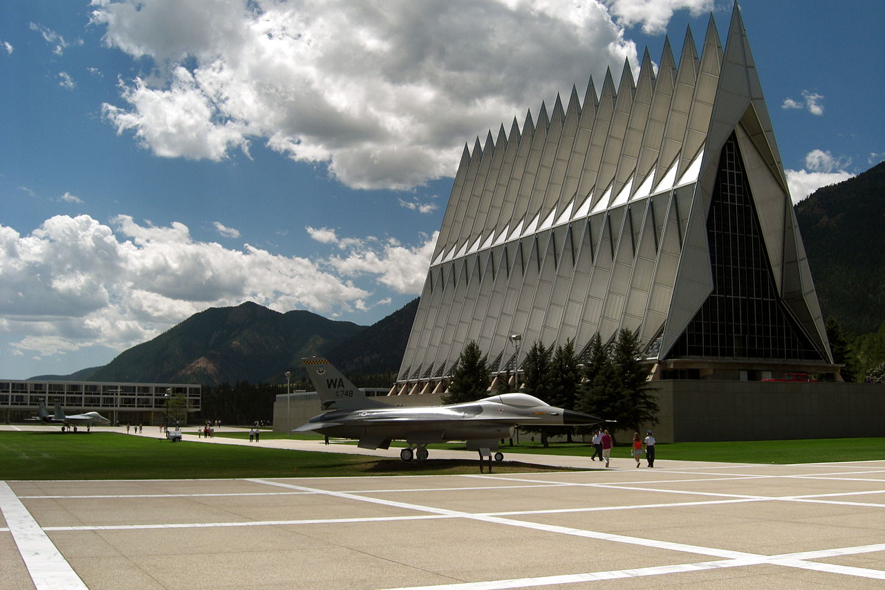
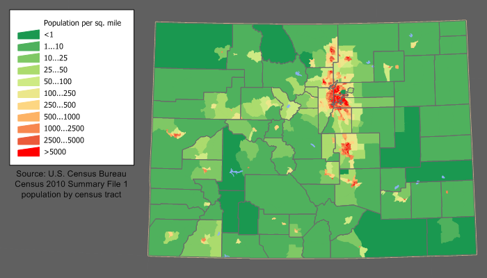
Denver anchors a large metropolitan area and serves as the cultural and economic hub. Other significant urban centers include Colorado Springs and Aurora, both of which are part of the state's broader Front Range corridor. These cities, together with surrounding suburbs and smaller towns, concentrate much of Colorado's population, services, and industry.
Economy and natural resources
Colorado's economy blends natural-resource industries with modern sectors. Historically important activities include mining and agriculture; energy production from oil, natural gas, and coal has also shaped development. In recent decades tourism, outdoor recreation (notably skiing and hiking), aerospace, and technology companies have become major economic drivers. The state's national parks, ski areas, and public lands attract visitors year-round.
History and development
Indigenous peoples inhabited the region for millennia before European exploration and settlement. The 19th century brought waves of migration tied to fur trading, gold and silver discoveries, and railroad expansion. Territorial organization preceded statehood, and Colorado's admission in 1876 marked a turning point as communities diversified beyond extractive industries and established civic institutions.
Culture, recreation and notable facts
Outdoor life is central to Colorado's identity: hiking, skiing, rafting, and mountain biking are widespread. The state contains national forests and parks that preserve scenic and ecological values. Colorado also plays a significant role in western water management because many major rivers begin here. Among other distinctions are its varied climate zones, high elevation communities, and a blend of urban and rural lifestyles.
- Landscape: Rocky Mountains and High Plains.
- Largest city: Denver.
- Statehood: 38th state, admitted August 1, 1876.
- Notable rivers: Colorado River, Arkansas River, Rio Grande.
Geography
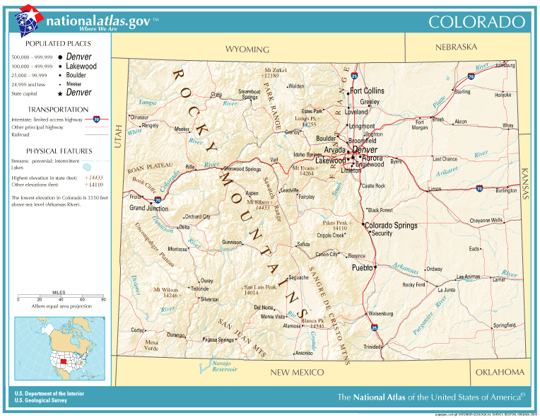
The state of Colorado is located in the central to western part of the United States and is surrounded by a total of seven states. Its northern neighbor is Wyoming, to the east Colorado borders the prairie states of Nebraska and Kansas, and on the southeastern border Colorado is separated from Texas by the relatively small strip of land of the Oklahoma Panhandle. While to the south it shares a border with New Mexico, Colorado does not share a border with the state of Arizona to the southwest, but merely meets it with its most southwestern corner. Together with New Mexico, Arizona, and Utah, its neighbor to the west, Colorado forms what are known as the Four Corners states; this phenomenon, unique in the United States, has been marked with a monument at that location. Along with Wyoming and Utah, Colorado is one of three U.S. states that have virtually no natural state boundaries, but are almost entirely defined along lines of longitude and latitude. Colorado extends approximately rectangularly from about 37° N to 41° N and 102° W to 109° W.
Colorado is crossed in the central and western part of the state by the mountain ranges of the Southern Rockies, of which the San Juan Range in the southwest, the Sawatch Range in the center and the two eastern foothills of the Rockies, Front Range and Sangre de Cristo Range, are among the most important mountains. The Colorado Rockies include more than 50 peaks with more than 4000 meters of altitude - among them Mount Elbert, the highest mountain of the entire Rocky Mountains with 4401 meters - and enclose several larger valley basins. The South Park Basin, which covers about 2800 square kilometers, is entirely in Park County and includes a vast grassland between the Front Range and Mosquito Range. In south-central Colorado, the San Juan Mountains and Sangre de Cristo Range enclose the San Luis Valley. The largest alpine valley basin in the world, it is itself no longer included in the Rocky Mountains, but in the mostly New Mexico Mesa and Plains.
In the west, the Rocky Mountains mostly end before the Utah state border and merge into a plateau that extends into Arizona - the so-called Colorado Plateau. Within Colorado, this includes the area from the foothills of the San Juan Mountains to the New Mexican border in the southwest. From the southwestern corner of the state, the plateau extends along the Utah border to more Rocky Mountains ranges to the east, and finally ends in its northern course at the Uinta Mountains in northwestern Colorado. Beyond this mountain range is the southern end of the Wyoming Basin - the steppe landscape that runs through the entire neighboring state of Wyoming all the way to Montana. Colorado's share is limited to the part between the Uinta and Elkhead Mountains in the northwest and the North Platte Basin in north-central Colorado, which is surrounded by the Park Range, Rabbit Ears Range and Medicine Bow Mountains.
East of the Rocky Mountains begin the Great Plains, a huge steppe landscape that runs through the entire center of the United States and is called High Plains within Colorado because of its here still high location. From the foothills of the Rocky Mountains they drop steadily from about 1900 meters and form at Kansas' border - near the Arkansas - with 1021 meters the lowest point of Colorado.
Waters
Three of the most important North American rivers, the Colorado, the Arkansas and the RioGrande, each over 2,000 kilometres long, have their headwaters on the continental divide running through the whole of Colorado. The North and South Platte Rivers are also important; with the exception of the Colorado, which flows into the Pacific, they all originate on the eastern side of the watershed and flow in the direction of the Atlantic.
In and around Rocky Mountain National Park lie a multitude of Colorado's 2183 natural lakes; just outside the park boundary is Grand Lake - already the state's largest natural lake with a water surface area of just 2.4 square miles. It is connected by a channel to the two larger reservoirs, Shadow Mountain Lake and Lake Granby, which together form the Great Lakes of the Rockies within the Arapaho National Recreation Area. Larger than Lake Granby within Colorado is only Blue Mesa Reservoir near Gunnison in the central to southwestern part of the state. John Martin Reservoir in the southeastern part of the state is also a major water reservoir for the region there.
Climate
Colorado has warm, partly hot summers and cold, snowy winters (continental climate). Especially the difference between day and night is sometimes extreme. Thus, despite high daytime temperatures, it can get very cold at night in summer. Precipitation (approx. 400-500 mm annually) is distributed throughout the year, with a slight preponderance in summer, when the air is usually very dry with 50% humidity.


History
Native American
In 400 A.D., the western spurs of the Fremont Indian culture reached into eastern Colorado. A thousand years before the arrival of the first whites in Colorado, representatives of the Anasazi culture settled in what is now Mesa Verde National Park in the far southwest of the state and built impressive structures such as the Cliff Palace. In historical times, mainly Cheyenne and Ute Indians lived in the region. To the southwest, the Navajo sphere of influence extended into Colorado, and from the southeast, that of the Kiowa as well.
Discovery and conquest by the Spanish and French
Colorado was probably first explored by the Spanish in the early 17th century. It is disputed whether the Spaniard Francisco Vásquez de Coronado, on his expedition from Mexico to present-day Kansas (1540-1542), already roamed the eastern plains of present-day Colorado and was thus the first European on the soil of what is now the state. Juan de Oñate, who led an expedition from New Mexico to Kansas about the year 1600, is also mentioned in this connection. However, the southeastern part of present-day Colorado was not claimed for the Spanish kingdom until 1706 by Juan de Uribarri. The territorial claim collided with the economic interests of the French, although the latter primarily promoted colonization on the St. Lawrence River (today Canada).
After its defeat in the French and Indian War (1754-1760) by the British Empire, however, France had to cede all territories west of the Mississippi, with the exception of New Orleans, to Great Britain, which in turn - as compensation for the conquest of Florida - ceded the central part of North America (which later became the Louisiana Territory) to the Spanish. This caused tension between Spain and France, which only ended on October 1, 1800, under pressure from Napoleon I, with the Peace of San Ildefonso and the consequent reconquest of the Central American territories by France. Only a little later, in 1803, the territory finally fell to the United States through the so-called Louisiana Purchase.
While the western part of today's Colorado - the southern Rocky Mountains and parts of the Colorado Plateau - remained undisputed territory of the Spanish (New Spain), the first explorations by the US Americans began in the east in 1806. A first deployment of American soldiers under the leadership of Zebulon Pike led in the Pike Expedition from Fort Bellefontaine (near Saint Louis) to the eastern foothills of the Rocky Mountains (Front Range), which were reached by the end of 1806. The exploration focused on the Arkansas River basin, which - although no official boundary was ever agreed upon between France and Spain until the Louisiana Purchase - was considered by the U.S. to be the southern border with New Spain. It was not officially established until 1819 in the so-called Adams-Onís Treaty, in which the western boundary was agreed upon along with the Arkansas to the south with the Continental Divide. This was followed in 1820 by the second major expedition led by Stephen H. Long, which focused on the course of the South Platte River and the region around present-day Denver.
First settlement by Europeans
Although more and more fur trappers advanced into what is now Colorado after Pike and Long's initial explorations in subsequent years, major settlement did not begin until the 1830s with the construction of Bent's Fort. Built in 1833 on the Arkansas (near present-day La Junta) by William and Charles Bent, the fort quickly became a major trading post between white and indigenous populations along the Santa Fe Trail. Meanwhile, in the San Luis Valley between the San Juan Mountains and the Sangre de Cristo Range, New Mexican settlers settled and made a living from farming. With San Luis, they founded the first permanent settlement in what would later become Colorado on June 21, 1851.
Meanwhile, beginning in 1850, the political division of the land acquired in the Louisiana Purchase began in the east, as well as the newly acquired territories from the Rocky Mountains to the Pacific coast after the war with Mexico (1846-1848). The so-called Kansas-Nebraska Act established the boundary between the territories of Nebraska and Kansas. The latter at that time extended beyond the present western boundary and occupied most of the High Plains lying between the South Platte and Arkansas Rivers to the Front Range. In the mountains it was joined by Utah Territory, which had already been established in 1850, while the remainder of what is now Colorado was parts of Nebraska (northeast) and New Mexico (south). The Colorado Territory, on the other hand, did not come into existence until 1861 with the gold rush in the Pikes Peak Country.
Gold rush and silver boom
While relations between whites and Indians - after initial reservations - had been mostly friendly in the High Plains region up to that time, this changed from the early 1850s onwards, when reports of gold discoveries in California led to ever-increasing flows of settlers through the Great Plains and the Rocky Mountains. When gold was also first found at the confluence of South Platte and Cherry Creek (now Denver) in June 1858, and prospectors established the first major settlements along the river and in the surrounding mountains, tensions between white and indigenous populations increased. In the mountains, the number of mining camps grew steadily and the region around Black Hawk, Central City, Nevadaville and Idaho Springs became a center of the gold rush around 1860.
However, the largest growth in the region, which was still part of Kansas at the time, was in Denver City, which was founded in 1858 and incorporated the neighboring town of Auraria two years later, bringing its population to around 6,000. The rapidly increasing population drove plans to establish a separate territory around the region. This finally happened on February 28, 1861, when U.S. President James Buchanan signed legislation to that effect in the U.S. Congress and appointed William Gilpin as the first governor. The young Colorado Territory was divided into 17 counties and had a population of around 25,000 at its founding; the capital was initially Colorado City. More important, however, remained Denver City, renamed "Denver" only in 1865, although the city had to be rebuilt after a major fire in 1863. In Golden, which replaced Colorado City as the territory's capital as early as 1862, Denver was designated Colorado's new capital in 1867. Although - it turned out rather quickly - Cherry Creek was not the vein of gold that had been hoped for, Denver benefited from the wealth of nearby towns in the Front Range. At the foothills of the Rocky Mountains, the capital city consolidated its central position with the consistent expansion of the rail network in the early 1870s. The first milestones were the connection to the network of the Kansas Pacific Railway, which extended its rail network from Kansas City to Denver in 1870, and the construction of the Denver and Pacific Railroad, which connected to the Union Pacific Railroad in Cheyenne (Wyoming). Denver's connection to southwestern Colorado followed in 1871 with the construction of the Denver & Rio Grande Railway. In 1872, the Colorado Central Railroad completed the route to the neighboring gold mining towns of Black Hawk and Central City.
In 1879, the silver boom broke out in Colorado and Leadville and Aspen became the most important mining towns during this time. Their development was supported by the further expansion of the Denver & Rio Grande Railway, which continued its network in the 1870s from Pueblo through the Royal Gorge in the direction of Leadville and finally reached the city in 1881. By this time, the economically emerging Colorado had long since achieved statehood. While many were initially concerned about higher taxes and too much interference from Washington, Colorado became the 38th state to join the United States on August 1, 1876, retaining its existing boundaries.
Indian eviction
The establishment of the Colorado Territory in 1861 and the rapidly increasing settlement on Cherry Creek was an affront to the Cheyenne and Arapaho, to whom the area around what would become Denver had been granted in the Treaty of Fort Laramie (1851). Their relocation to the Arkansas river valleys sparked backlash among Native Americans, ranging from stagecoach raids to the murder of isolated settlers. In a retaliatory attack unprecedented up to that time, troops of the Third Colorado Cavalry under commander John M. Chivington entered an unfortified Indian village on November 29, 1864, and murdered 133 men, women, and children. The cruel actions of the U.S. military in that Sand Creek massacre briefly sensitized the white population to the interests of the Indians, but also stood in the way of peaceful coexistence. The ensuing warfare lasted about five years and ended after the battles of Beecher Island (September 1868; near present-day Wray) and Summit Springs (July 1869) with the surrender of Cheyenne and Arapaho, who with several other Indian tribes had recently formed an alliance against the whites. A large-scale relocation of Indians from Colorado's Plains to reservations in Oklahoma had begun as early as 1867 and was considered largely complete by 1874.
The Ute Indians, living in the mountains and until then not fundamentally hostile to the U.S. government, also faced repression after gold and silver discoveries beginning in the 1870s, and in 1880 were sent by peace treaties to a small reservation in the Mesa region, on the border with New Mexico.
20th and 21st century
Colorado was hit hard by the economic crisis that began in 1893 (Panic of 1893; decline in the value of silver). In Denver, twelve banks had to be closed abruptly, countless businesses had to go out of business. Ambitious plans of the railroad companies were halted and the closing of many mines caused unemployment to rise rapidly. Many former mining towns degenerated into ghost towns in the 20th century, while better developed towns found new sources of income in tourism. In particular, Aspen, Breckenridge and Vail in central Colorado and Telluride in southwestern Colorado became popular winter sports resorts. The establishment of Rocky Mountain National Park in 1915 also created the first major tourist attraction in Denver's catchment area. In the state capital itself, a systematic upgrading of the cityscape along the lines of the City Beautiful movement began shortly after the turn of the century under Mayor Robert W. Speer. The beautification measures, which lasted for almost 15 years, served not least to moralize those Denverites who lived in the state capital under rather miserable conditions.
In 1977, Steamboat Springs hosted the first Special Olympics Winter Games.
On April 20, 1999, the Columbine High School shooting rampage occurred near Littleton, killing 15 people and injuring 24 others. The act caused a worldwide sensation, triggered numerous debates about the possible causes of youth violence and is considered a turning point in the culture of the United States due to its far-reaching consequences. On July 12, 2012, the city of Aurora made international headlines when 12 people were shot and 58 others were injured in the Aurora rampage during a screening of the movie The Dark Knight Rises.
In the summer of 2002, Colorado was hit by the most devastating forest fire in the state's history to date, when an illegal campfire in the Pike National Forest started the so-called Hayman Fire. The blaze destroyed some 55,000 acres of forestland and approached the Denver metropolitan area in such a threatening manner that individual suburbs had to be briefly evacuated. Finally, a natural disaster of a completely different kind occurred in December 2006, when the state was hit by a massive blizzard shortly before the Christmas holidays. Major interstate highways had to be temporarily closed, bringing public life in the Denver metropolitan area to a standstill. One of the worst blizzards in the Front Range region claimed four lives in Colorado.


Questions and answers
Q: What is Colorado?
A: Colorado is a state in the western United States.
Q: What is the capital of Colorado?
A: The capital of Colorado is Denver.
Q: What are some other large cities in Colorado?
A: Other large cities in Colorado are Colorado Springs and Aurora.
Q: When did Colorado become a state?
A: Colorado became the 38th state admitted to the union on August 1, 1876.
Q: Is Colorado located in the western or eastern United States?
A: Colorado is located in the western United States.
Q: What is the population of Denver?
A: The population of Denver is approximately 700,000 people.
Q: What is the significance of August 1, 1876 in Colorado's history?
A: August 1, 1876 is significant in Colorado's history because it marks the day that Colorado became the 38th state admitted to the union.
Related articles
Author
AlegsaOnline.com Colorado: Geography, history, economy and cultural highlights Leandro Alegsa
URL: https://en.alegsaonline.com/art/21751
Sources
- commons.wikimedia.org : Colorado
- presidency.ucsb.edu : "Proclamation of the Admission of Colorado to the Union"
- factfinder.census.gov : "2017 Population Estimates"
- kff.org : "Median Annual Household Income"
- history.com : "Pike expedition sets out"
- netstate.com : "50 State Elevations (mean elevation)"
- thetruesize.com : "The True Size Of..."
- cnn.com : "10 things to know about Colorado's recreational marijuana shops"
- huffingtonpost.com : "Colorado Recreational Marijuana Sales Exceed $5 Million In First Week"
- huffingtonpost.com : "Colorado's Weed Workers, They're Just Like Us!"