Cologne (Köln): Major German city on the Rhine
Cologne (German: Köln) is a historic and cultural center on the Rhine in North Rhine-Westphalia, known for its cathedral, Roman origins, museums, trade fairs, Kölsch beer and lively carnival.
Overview
Cologne (Köln in German) is one of Germany's largest cities, located in the state of North Rhine-Westphalia. It sits on the banks of the Rhine and forms part of the broader Rhine-Ruhr agglomeration, a densely populated industrial and urban area. With a population of about one million residents, Cologne functions as a regional cultural, educational and economic hub and is widely known beyond Germany for its architecture, museums and festivals.
Image gallery
2 Images

History and development
The city's roots extend to the Roman period when it was established as a colony; its Latin name reflected that origin. Over the centuries Cologne grew as a medieval trading center and later as an industrial and transport node. Key historical layers—Roman archaeology, medieval churches and modern 19th- and 20th-century urban development—are visible across the city. The cathedral, Kölner Dom, became a national symbol and is recognized internationally for its Gothic architecture and UNESCO status.
Sights, culture and identity
Cologne is noted for a concentrated set of landmarks and cultural institutions. Visitors and residents commonly cite the Kölner Dom, the Roman-Germanic Museum, Museum Ludwig (modern art), the Chocolate Museum and the Roman remains in the old town. The city also preserves numerous Romanesque churches and historic neighborhoods. Local identity is expressed in the Kölsch dialect and the light, top-fermented Kölsch beer. Cologne's carnival—an annual festival centered on parades and street celebrations—attracts large crowds and is a major element of civic life.
Economy, transport and institutions
Cologne is an economic center with a mix of manufacturing, trade fairs and media services. The Koelnmesse trade fair hosts national and international exhibitions; the city is also a base for broadcasters and publishing. Higher education and research are represented by institutions such as the University of Cologne. Transport links include an extensive local public transit network, long-distance rail, and Cologne/Bonn airport, which serves both domestic and international flights.
Climate, demographics and notable facts
The climate is temperate oceanic (Cfb), with moderate rainfall and mild seasonal variation. Cologne's population is diverse and multilingual, reflecting migration and its role as a regional magnet. It participates in regional planning across the Rhine-Ruhr area and is often referenced when discussing urban development and post-industrial transformation in Germany.
- Major festivals: Carnival and Christmas markets.
- Notable industries: trade fairs, media, chemical and automotive suppliers.
- Transport hubs: Rhine river traffic, rail, and Köln/Bonn airport.


Geographical position and climate
The urban area covers 405.17 km² (230.25 km² on the left bank of the Rhine, 174.87 km² on the right bank). Only the city-states of Berlin and Hamburg and four small and medium-sized cities in Saxony-Anhalt and Brandenburg have a larger urban area in Germany.
The city's topographic reference point, the top of the northern cathedral tower, is located at 50° 56′ 33″ north latitude and 6° 57′ 32″ east longitude. The highest point is 118.04 meters (Monte Troodelöh in the Königsforst); the lowest 37.5 meters above sea level (in the Worringer Bruch).
The city is located in the Cologne Bay, a funnel-shaped river valley landscape shaped by the Rhine between the stepped slopes of the Bergisches Land and the Eifel immediately after the Rhine emerges from the Rhenish Slate Mountains. This protected, favorable location results in a mild climate for Cologne.
| Cologne-Stammheim (43 m) 2015-2020 | ||||||||||||||||||||||||||||||||||||||||||||||||
| Climate diagram | ||||||||||||||||||||||||||||||||||||||||||||||||
| ||||||||||||||||||||||||||||||||||||||||||||||||
| Monthly average temperatures and precipitation for Cologne-Stammheim (43 m) 2015-2020
Source: [2] | |||||||||||||||||||||||||||||||||||||||||||||||||||||||||||||||||||||||||||||||||||||||||||||||||||||||||||||||||||||||||||||||||||||||||||||||||||||||||||||||||||||||||||||||||
Cologne is located in the greater area of the transition zone from a temperate maritime climate to a continental climate with mild winters (January average: 3.0 °C) and moderately warm summers (July average: 19.0 °C). The average annual precipitation is 802 millimeters, which is in line with the German average and considerably higher than in the neighboring Rhine-Erft district to the west (Erftstadt-Bliesheim: 631 mm) or the Jülich-Zülpicher Börde (Zülpich: 582 mm), which gives commuters the impression of a "rain hole".
The weather station Cologne-Stammheim can be used as a representative of the urban climate of Cologne. It can be seen that the winter temperatures are among the mildest in all of Germany and the temperature minima are very high due to the urban microclimate. The mean values from the period 2015-2020 are quite similar to the values from the climate mean of Lyon over the years 1961-1990.
| Cologne | ||||||||||||||||||||||||||||||||||||||||||||||||
| Climate diagram | ||||||||||||||||||||||||||||||||||||||||||||||||
| ||||||||||||||||||||||||||||||||||||||||||||||||
| Climate data Cologne
Source: DWD, data: 1991-2020 | |||||||||||||||||||||||||||||||||||||||||||||||||||||||||||||||||||||||||||||||||||||||||||||||||||||||||||||||||||||||||||||||||||||||||||||||||||||||||||||||||||||||||||||||||||||||||||||||||||||||||||||||
| Cologne | ||||||||||||||||||||||||||||||||||||||||||||||||
| Climate diagram | ||||||||||||||||||||||||||||||||||||||||||||||||
| ||||||||||||||||||||||||||||||||||||||||||||||||
| Climate data Cologne
Source: DWD, data: 1961-1990 | |||||||||||||||||||||||||||||||||||||||||||||||||||||||||||||||||||||||||||||||||||||||||||||||||||||||||||||||||||||||||||||||||||||||||||||||||||||||||||||||||||||||||||||||||||||||||||||||||||||||||||||||||||||||||||||||||||||||||||||||||||||||||||||||||||||||||||
Over the past 30 years, temperatures in Cologne have risen noticeably on a long-term average; while the average daily maximum temperature in July for the period 1961 to 1990 was still around 23 °C, it is around 25 °C for the years 1991 to 2020. Winters have also become warmer; while the average daily maximum temperature in January for the years 1961 to 1990 was still 4.5 °C, it was 5.9 °C for the period 1991 to 2020.
The mean precipitation profile, however, has hardly changed, the annual precipitation amount has remained about the same on average. On the other hand, the number of sunshine hours has increased from 4.1 to 4.4 hours per day over the last 30 years.
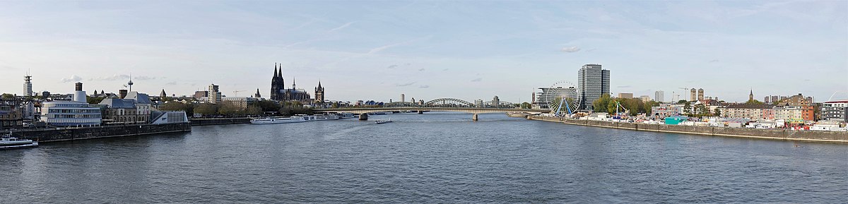
enlarge and show information about the image
![]()
Cologne panorama seen from Severinsbrücke bridge looking north, October 2019
Air quality and environmental protection
Energy production, industry and traffic are the most important causes of anthropogenic air pollution. Within the framework of air pollution control planning to date, considerable successes have been achieved for almost all air pollutants, in particular for particulate matter, which was still critical at the beginning of the 2000s. To protect human health, the annual limit value of 40 µg/m³ was set for nitrogen dioxide (NO₂) throughout Europe in 2010, and a critical value of 30 µg/m³ NOx is used as the annual mean value to protect vegetation. These limit values are still exceeded over large areas in Cologne.
In order to permanently reduce air pollution, the Cologne district government drew up a clean air plan for the first time in 2006 in accordance with Section 47 (1) of the Federal Immission Control Act (BImSchG). The purpose of such an air pollution control plan is to describe the situation in which air pollution levels are exceeded, to analyze the causes, to consider the probable development of the pollution situation, and to develop measures that should lead to a reduction in air pollutants. On January 1, 2008, the first environmental zone in North Rhine-Westphalia was therefore established in Cologne, covering the inner area of the city. Since compliance with the limit values for nitrogen dioxide could not yet be achieved as a result, the clean air plan was updated and the environmental zone was extended to almost the entire city area on April 1, 2012. Following a gradual introduction, only vehicles with a green sticker have been allowed to enter the low emission zone since July 1, 2014.
As the applicable limit value for nitrogen dioxide was still exceeded at nine measuring stations in Cologne in 2016, the district government had to update the current clean air plan for the Cologne urban area. Overall, at all measuring points affected by limit value exceedance, the emission share of road traffic has the highest share in the existing pollution situation. A large proportion of this results from nitrogen dioxide emissions from diesel vehicles. The annual mean limit value for particulate matter has been complied with at all measuring points in Cologne since 2009. The location of the areas where elevated levels of pollution occur covers a larger area around the city center and individual areas in the outer parts of the city. The five largest problem areas are the Clevischer Ring (Cologne-Mülheim), Justinianstrasse (Deutz), Neumarkt (City), along Aachener Strasse (Weiden) and Luxemburger Strasse (Sülz). In this respect, there is a need for action to further reduce air pollution in the planning area.
Since mid-August 2019, trucks over 7.5 tons have been banned from passing through Cologne's city center as part of the clean air plan. Delivery traffic and residents are not affected by the ban. The city of Cologne participates in the annual "Earth Hour" organized by the World Wide Fund For Nature (WWF) since 2007.
Geology
→ Main article: Geology of the Lower Rhine Bight
Cologne is located on the southern edge of the Lower Rhine Bay for the most part in the area of the low terraces, which rise slightly from the Rhine like terraces. The geological substructure in the city area is formed by deposits of the glacial period (Quaternary) up to 35 meters thick. They consist of gravels and sands of the Rhine-Meuse system. The foothills of the Rhenish lignite mining area extend as far as Kalk: The lignite mine Gewerkschaft Neu-Deutz was founded there around 1860. Today, the site is home to the brewery of the Sünner brothers, which was able to use the groundwater seeping into the adit. Tertiary and Devonian strata follow in the deeper subsoil.
The soil composition is characterized by the fertile soils of the alluvial plain along the Rhine. In the western parts of the city, they are covered by loess, which has weathered into productive loamy soils used for agriculture (parabraunerden). They are often associated with fertile colluvia, which developed in depressions from washed away soil material. At the end of the last ice age, the Rhine deposited sandy to loamy sediments in the Rhine plain to the east, which is divided by silted-up oxbow lakes. From this, productive parabraunerden and braunerden were formed, which are also used for agriculture. In the Rhine floodplain, fertile brown alluvial soils were formed by periodic flooding of alluvial soil material. The extreme east of the urban area already belongs to the base of the Rhenish slate mountains. Here, geologically older terrace sands and drift sands are widespread, from which mostly poorer brown soils, acidic podsol brown soils and, in the case of dense subsoil, waterlogged pseudogleyes developed. These rather inferior soils are used as heaths and forestry, respectively. Along streams and in gullies, as in the Rhine floodplain, groundwater-influenced gleye formed.
Tectonic movements of the Rhine Graben fault created pronounced terrain ridges around Cologne, such as the Ville near Frechen. Immediately to the west is Germany's most active earthquake zone, whose epicenter is in the Düren district. For earthquake prevention, the Department of Earthquake Geology at the University of Cologne installed a measuring network with 19 "Strong Motion Stations" between Aachen, Bensberg, Meckenheim and Viersen in 2006 and expanded it to 24 stations by 2018. Microearthquakes that are not perceptible occur several times a month in the Cologne Bay area.
Cologne and the Rhine
The Rhine, known as the Lower Rhine after it emerges from the slate mountains south of Cologne, reaches the city at Godorf and leaves it at Worringen. The gradient of the river is about 0.2 per mille. Its current water level can be read from the clock at the Cologne gauge. Normally, this shows 3.48 meters, which stands for a water depth in the navigation channel of about 4.48 meters.
Cologne was affected by floods on several occasions. The worst recorded flood occurred in February 1784, when a temperature surge set in after the extremely long and cold winter of 1783/84. The Rhine was frozen solid and the melting snow and breaking ice caused a record level of 13.55 meters. The floods, on which heavy ice floes floated, devastated large parts of the riverbank development and all the ships. The floes destroyed individual buildings, including fortifications; there were 65 deaths. The flood of water and ice completely destroyed the Bergisch district town of Mülheim am Rhein on the right bank of the Rhine, now a district of Cologne.
In the 20th century, the three floods of the century in 1926, 1993 and 1995 reached levels of up to 10.69 meters. Since 2005, a flood protection concept has been implemented that uses fixed or mobile walls to protect the city up to a level of 11.90 meters. On several occasions, the Rhine was at low water. On September 20, 2003, at 8 a.m., the Rhine reached 0.8 meters at the Cologne gauge. This was below the lowest recorded value from 1947. However, this negative record was broken in October 2018. First, the record level was reached on October 18. On October 23, the water level was only 0.67 meters. However, the 0 meter level means that the 150 meter wide navigation channel in the middle of the river still has one meter of water depth. Inland navigation had to accept restrictions and was not completely stopped, as on the Elbe.
The following list shows the water volumes that move through the city depending on the water level: 0.80 m (lowest water level): 630 cubic meters/second; 3.48 m (normal water level): 2000 m³/s; 6.20 m (high water mark I): 4.700 m³/s; 8.30 m (high water mark II): 7200 m³/s; 10.0 m (high water mark in Altstadt, Rodenkirchen and Zündorf): 9700 m³/s; 10.69 m (high water in January 1995): 11,500 m³/s.
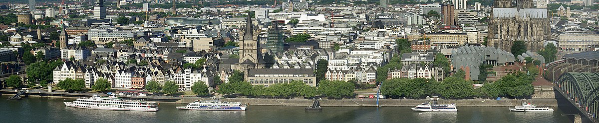
enlarge and show information about the image
![]()
Panorama of the Old Town embankment. In the center Groß St. Martin, on the right Kölner Philharmonie and Museum Ludwig, on the very outside Hohenzollernbrücke with entrance to Kölner Hauptbahnhof, July 2006.
Neighboring communities
Cologne is the center of a metropolitan area comprising about two million inhabitants. In a closed settlement area, the following cities border directly on the city area in a clockwise direction, starting in the northeast: Leverkusen (independent city), Bergisch Gladbach and Rösrath (Rheinisch-BergischerKreis), Troisdorf and Niederkassel (Rhein-Sieg-Kreis), Wesseling, Brühl, Hürth, Frechen and Pulheim (all Rhein-Erft-Kreis), Dormagen (Rhein-Kreis Neuss) and Monheim (Kreis Mettmann).
The town of Wesseling had been incorporated into Cologne on January 1, 1975, but regained its independence on July 1, 1976, following a court decision.
| Pulheim | Dormagen, Monheim on the Rhine | |
| Frechen, Hürth |
| Bergisch Gladbach, Rösrath |
| Brühl, Wesseling | Niederkassel |

City breakdown
See also: List of Cologne's boroughs and districts
The city of Cologne is divided into 86 districts, which are grouped into 9 boroughs. The city of Cologne numbers the boroughs from 1-9 and the districts from 101-105, 201-213, 301-309, 401-406, 501-507, 601-612, 701-716, 801-809 and from 901-909, where the hundreds digit corresponds to the number of the borough. However, the district number has nothing to do with the postal code.
Within the districts, the people of Cologne still distinguish between different "Veedeln" (Kölsch for neighborhoods), whose residents often maintain social ties and contacts reminiscent of village communities. However, the boundaries and designations of the Veedel vary, sometimes considerably, depending on how the residents view them. The Office for Urban Development and Statistics has defined 371 neighborhoods - strictly speaking, parts of neighborhoods including the neighborhoods themselves - for statistical evaluations, which include residential places with few inhabitants and settlements as well as commercial areas.
| Cologne city division | ||||||
| No. | Municipality | Coat of arms | Residents | Surface area | Inhabitants per | Districts |
| 1 | Downtown | - – | 129.055 | 16,37 | 7.884 | Old Town South, New Town South, Old Town North, New Town North, Deutz |
| 2 | Rodenkirchen |
| 111.040 | 54,55 | 2.035 | Bayenthal, Marienburg, Raderberg, Raderthal, Zollstock, Rondorf, Hahnwald, Rodenkirchen, Weiß, Sürth, Godorf, Immendorf, Meschenich |
| 3 | Lindenthal | - – | 153.600 | 41,80 | 3.675 | Klettenberg, Sülz, Lindenthal, Braunsfeld, Müngersdorf, Junkersdorf, Weiden, Lövenich, Widdersdorf |
| 4 | Ehrenfeld |
| 109.770 | 23,98 | 4.578 | Ehrenfeld, Neuehrenfeld, Bickendorf, Vogelsang, Bocklemünd/Mengenich, Ossendorf |
| 5 | Nippes | - – | 118.577 | 31,75 | 3.735 | Nippes, Mauenheim, Riehl, Niehl, Weidenpesch, Longerich, Bilderstöckchen |
| 6 | Chorweiler | - – | 82.732 | 67,16 | 1.232 | Merkenich, Fühlingen, Seeberg, Heimersdorf, Lindweiler, Pesch, Esch/Auweiler, Volkhoven/Weiler, Chorweiler, Blumenberg, Roggendorf/Thenhoven, Worringen |
| 7 | Porz |
| 114.699 | 78,92 | 1.453 | Poll, Westhoven, Ensen, Gremberghoven, Eil, Porz, Urbach, Elsdorf, Grengel, Wahnheide, Wahn, Lind, Libur, Zündorf, Langel, Finkenberg |
| 8 | Lime |
| 121.637 | 38,16 | 3.187 | Humboldt/Gremberg, Kalk, Vingst, Höhenberg, Ostheim, Merheim, Brück, Rath/Heumar, Neubrück |
| 9 | Mülheim |
| 150.709 | 52,20 | 2.887 | Mülheim, Buchforst, Buchheim, Holweide, Dellbrück, Höhenhaus, Dünnwald, Stammheim, Flittard |
| Total | City of Cologne |
| 1.091.819 | 404,9 | 2.697 | |
63 percent of Cologne's inhabitants live on the left bank of the Rhine (as of 2016). Since the historic city center is located on the left bank of the Rhine, the right side of the Rhine is referred to condescendingly in dialect as the "Schäl Sick".
Flora and fauna
Cologne has extensive green spaces, which are designed as parks in the urban area and are mostly managed forests in the outer districts. In addition, there are 22 nature reserves, for example the Worringer Bruch in the extreme north of Cologne on the left bank of the Rhine, a former branch of the Rhine that is now silted up. It provides a home for rare animal and plant species and a characteristic floodplain and forest landscape. On the right bank of the Rhine, there are mainly open forest and heath landscapes, such as the Wahn Heath, the Königsforst nature reserve and the Dünnwald Forest. According to the area survey of 2016, Cologne has 5406 hectares of forest area, which corresponds to 13.3% of the city area.
The fauna has a very high number of cultural followers. In addition to pigeons, mice and rats, which are ubiquitous and often perceived as a nuisance, red foxes have migrated into the urban area in significant numbers. They can now be found in the inner city, where they use allotments and parks as their hunting grounds. As a result of improvements in water quality, the Rhine flowing through Cologne has once again become home to many formerly present and newly immigrated species.
Various non-native animals have settled in Cologne's green spaces, favored by the mild climate. Larger populations of collared parakeets and the Great Alexander Parakeet live, among other places, in the Melaten cemetery and the grounds of the Riehler Heimstätten. Originally introduced to Germany from Asian mountain regions (India, Afghanistan) for zoo and home keeping, these parrots/parakeets have become established as neozoa. Information about the size of the populations ranges from a few 100 specimens to over 1000.


Politics
Election of the Cologne City Council 2020
in percent
%
30
20
10
0
28,5
21,6
21,5
6,5
5,3
5,0
4,4
2,5
2,0
2,9
Gains and losses
In Roman times, the respective admiral of the Classis Germanica headed the municipal administration. Later, the Roman municipal constitution was introduced. Since the city was the seat of an archbishopric, the archbishop later gained complete power in Cologne. However, the city tried to break away from the archbishop, which it finally succeeded in doing in the 13th century (from 1288 de facto Free Imperial City). There is evidence of a city council as early as 1180. From 1396, the 22 gaffs were the political backbone of the city administration. They elected the 36-member council, which in turn could elect 13 additional persons. The composition of the council changed every six months by replacing half of the members. The council elected two mayors annually. During the French occupation from 1794, the municipal constitution was introduced in 1798, which was based on French models. The city administration was headed by a maire (mayor) appointed by the French government. After the transfer to Prussia in 1815, Cologne became a district-free city in 1816 and at the same time the seat of the administrative district of Cologne, which was not dissolved until the territorial reform of 1975. Since 1815, the city was headed by a mayor, and there was also a council. In 1856, the Prussian city ordinance of the Rhine Province was introduced. The city council elected the lord mayor as the formal head and head of the city's administration.
In 1933, the then Lord Mayor Konrad Adenauer was expelled by the National Socialists. During the Nazi period, the Lord Mayor was appointed by the NSDAP. After World War II, the military government of the British occupation zone appointed a new Lord Mayor and in 1946 introduced the municipal constitution based on the British model. According to this, there was a city council elected by the people, which elected the Lord Mayor from among its members as the council chairman and representative of the city, who served in an honorary capacity. A new feature was the office of the full-time chief city manager, also elected by the council, who acted as the head of the city administration.
In 1999, the dual leadership in the city administration was abandoned. Since then, there has only been a full-time mayor. He is chairman of the council, head of the city administration and representative of the city. Since then, he has been directly elected by the residents of Cologne. The Lord Mayor is assisted by other mayors, currently (as of 2014) four, who are provided by the strongest parliamentary groups in the Council.
See also: List of mayors of the city of Cologne
Traditions, mentality and politics
The long tradition of a free imperial city, the long exclusively Catholic population and the centuries-old antagonism between church and bourgeoisie (and within the latter between patricians and artisans) has created its own political climate in Cologne. Various interest groups often form on the basis of social socialization and therefore across party lines. The resulting network of relationships linking politics, business and culture in a system of mutual favors, obligations and dependencies is called the Cologne Klüngel. Heinrich Böll described this historically shaped network in his essay Was ist kölnisch (What is Cologne). This coterie has often led, for example, to an unusual distribution of proportional representation in the city administration and has sometimes degenerated into corruption: The "garbage scandal" uncovered in 1999 about bribes and inadmissible party donations not only landed businessman Hellmut Trienekens in jail, but brought down almost the entire leadership of the ruling SPD.
While the city's Catholic tradition in the Empire and the Weimar Republic gave it strong ties to the Zentrum party, soon after the war the political majority changed from the CDU (in which the Zentrum was absorbed) to the SPD. The latter ruled for over 40 years, sometimes with an absolute council majority. Due to its liberal traditions, Cologne has always been a stronghold of the FDP, and because of its tolerant social climate, also of the Greens, who emerged victorious from a local election for the first time in 2020.
Council of the City of Cologne
See also: Results of the local elections in Cologne
The Council of the City of Cologne has 90 elected city council members ("MdR", Member of the Council). Bündnis 90/Die Grünen are the largest parliamentary group for the first time since the 2020 municipal elections, with 26 members. The SPD and the CDU are each represented by 19 members. Also represented in the City Council are Linke (6 members), the FDP (5 members), the AfD (4 members), Volt (4 members), the voter group GUT (2 members), the PARTEI (2 members), the Klima Freunde (2 members) and the Freie Wähler Köln (1 member).
Since the beginning of 2021, the Greens, the CDU and Volt have formed a coalition in the council, where they hold the majority.
For representational purposes, the council of the old trading and inland port city acquired a council ship in 1938, the City of Cologne, which is now a listed monument.

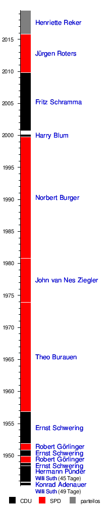
Mayor
→ Main article: List of mayors of the city of Cologne
The mayor of the city of Cologne is Henriette Reker (independent). As a joint candidate of the CDU, Greens and FDP, she received 52.66 percent of the votes cast in the municipal election on October 18, 2015. On September 13, 2020, she ran again, with the support of the CDU and the Greens. She missed an absolute majority this time and subsequently won the runoff election on September 27, 2020, with 59.27%. Her term of office is five years.
| Election of the Lord Mayor of Cologne 2020 in percent % 60 50 40 30 20 10 0 45,1 % 26,8 % 7,2 % 4,5 % 4,2 % 3,5 % 3,4 % 2,1 % 1,1 % 2,4 % Reker Kossiski Detjen Fox Cremer Gabrysch Campione Carpenter Langel Otherwise. Template:Election chart/maintenance/new result not 100% | Run-off election in percent % 60 50 40 30 20 10 0 59,3 % 40,7 % Reker Kossiski |
Since 1999, the mayors in North Rhine-Westphalia no longer represent their cities and municipalities exclusively politically, but once again simultaneously head the local governments, which between 1945 and 1999 were headed by an additional full-time official, the Lord Mayor in large cities.
Municipality
→ Main article: Municipality of Cologne
The Cologne city administration consists of seven departments, each of which is headed by a professional city councilor as an elected municipal official, and the department of the Lord Mayor. The Cologne city administration employs around 17,000 people. As city director, Stephan Keller is the first representative of the Lord Mayor within the city administration. He also heads the Department for General Administration, Order and Law.
District Representatives
Parallel to the council elections, a district representative is elected in each of the nine city districts in accordance with the requirements of the municipal code of North Rhine-Westphalia. In the 2020-2025 municipal election period, all nine district councils in Cologne will each have 19 municipal district councillors ("MdBV", member of the district council) including the district mayor. These represent the interests of the districts and the associated neighborhoods vis-à-vis the City Council. They have decision-making authority in matters of local significance that do not extend beyond the district boundaries; in matters that also affect the city district, they have a right to be heard. Cologne's district councils are responsible for city districts that already meet the definition of a large city, due to a population of over 100,000 in each district. Only the borough of Chorweiler, with just over 82,000 inhabitants, is below this. They are represented by the district mayor.
See also: Results of the elections to the Cologne district councils
Sovereign symbols of the city of Cologne
→ Main article: Cologne coat of arms
|
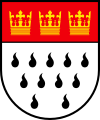
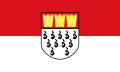
| Blasing: "Under red shield head, therein barred three golden trifoliate crowns, in silver 11 black flames (5:4:2)." |
| Coat of arms justification: The coat of arms of the city of Cologne shows the double-headed imperial eagle holding a sword and scepter. It is a reminder that the city officially belonged to the Holy Roman Empire of the German Nation as a Free Imperial City in the Middle Ages since 1475. The eagle has two heads because the emperor was also the Roman-German king. The shield has the colors red and white, the colors of the Hanseatic League. Cologne, as an important trading metropolis, not only belonged to this alliance of merchants and cities, but was - together with Lübeck - co-founder of the German Hanseatic League and thus one of the oldest Hanseatic cities in Germany. The three crowns have been the city's emblem since the 12th century; they commemorate the Magi, whose relics were brought from Milan by Cologne Archbishop Rainald von Dassel in 1164 and are kept in a golden shrine behind the cathedral's high altar. |
· 
Small coat of arms
· 
Flag
· ![]()
Banner flag
· 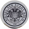
Official seal
· ![]()
Cologne Municipality Logo
· 
Emblem of the city administration of Cologne
The very popular cult of St. Ursula is commemorated by the eleven black "flames" that have appeared on Cologne's coat of arms since the 16th century. According to legend, Ursula was a Breton princess who, on her way back from a pilgrimage to Rome, was murdered along with her companions by the Huns who were besieging Cologne at the time. The eleven or 11,000 legendary maidens are symbolized in the city's coat of arms by the eleven drop-shaped ermine tails, which in turn could be reminiscent of the coat of arms of Brittany - Ursula's homeland - which is made of ermine fur. It is possible that the Huns passed by Cologne on their way to or from the battle on the Catalaunian Fields in 451, which could be the historical basis of the legend.
The flag of the city of Cologne is red and white striped lengthwise. It is often shown with the city's coat of arms applied.
Town twinning
Cologne is one of the six European cities that first established a ring partnership in 1958. This act, which took place immediately after the founding of the EEC, was intended to underline European solidarity by twinning one city from each member state at the time with all the others. In 1993, the partnership between the participating cities of Cologne, Turin, Liège, Esch an der Alzette, Rotterdam and Lille was reaffirmed.
|
|
Through the incorporated cities and towns, Cologne took over their twinning relations with the cities of Benfleet/Castle Point (United Kingdom), Igny (France), Diepenbeek (Belgium), Brive-la-Gaillarde (France), Dunstable (United Kingdom), Eygelshoven (Netherlands) and Hazebrouck (France). In the latter case it is about Porz; the nevertheless existing partnership association points out a curious trifle: Walnuts are thrown there instead of Kamelle.
Since the founding of the "One World City of Cologne" network in 2011, the City of Cologne has also been very active in municipal development cooperation. The "Fördertopf Entwicklungszusammenarbeit" (development cooperation funding pot) provides targeted support for the implementation of the United Nations' Sustainable Development Goals (SDGs) at the local level by civil society. The focus here is on education and public relations work as well as raising awareness of the international aspects of the 17 Sustainable Development Goals (SDGs).
Special funding priorities in 2021 are the anniversaries "25 years Cologne-Bethlehem" and "10 years Cologne-Rio de Janeiro".


Questions and answers
Q: What is the name of the city in Germany?
A: The city in Germany is called Cologne. It is also known as Köln and Kölle in German and Kölsch, respectively.
Q: How many people live in Cologne?
A: Approximately 1,060,000 people live in Cologne.
Q: What state is Cologne located in?
A: Cologne is located in the state of North Rhine-Westphalia.
Q: Is Cologne part of a larger urban area?
A: Yes, it is part of the 'Rhine-Ruhr agglomeration' which has a combined population of about 10 million people. This makes it one of the most densely populated areas of the world.
Q: Where does Cologne lie on the Rhine River?
A: Cologne lies on the Rhine River in its southern region.
Q: What type of climate does Cologne have?
A: The climate for Cologne is classified as oceanic (Cfb) according to the Koeppen climate classification system.
Related articles
Author
AlegsaOnline.com Cologne (Köln): Major German city on the Rhine Leandro Alegsa
URL: https://en.alegsaonline.com/art/21682
Sources
- destatis.de : "Alle politisch selbständigen Gemeinden mit ausgewählten Merkmalen am 31.12.2018 (4. Quartal)" · web.archive.org
- it.nrw.de : "Amtliche Bevölkerungszahlen"
- capturedplaces.com : "Eau de Cologne"