Alberta — province in western Canada
Overview of Alberta: geography, major cities, history, economy and notable facts about the western Canadian province.
Overview
Alberta is a province in western Canada bordered to the west by British Columbia, to the east by Saskatchewan, to the south by the U.S. state of Montana and to the north by the Northwest Territories. It covers a large area of the Canadian interior and is one of the country’s most economically important provinces. Edmonton, near the provincial centre, is the capital (Edmonton), while Calgary is its largest urban centre and a major business hub.
Image gallery
10 Images


Geography and climate
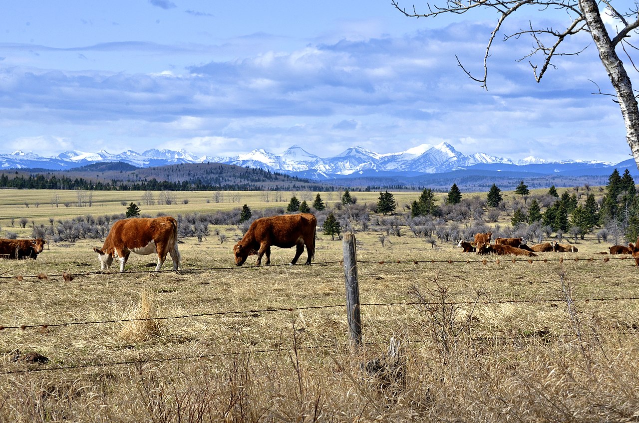
The province stretches from the peaks of the Canadian Rockies in the west across foothills to vast prairie and parkland in the east, with regions of badlands and river valleys. Alberta’s climate is broadly continental: winters can be cold and snowy, while summers are warm to hot on the plains with milder conditions in the mountains. The variation in terrain supports diverse ecosystems and outdoor recreation opportunities.
History and peoples
Long before European contact the area was home to many Indigenous nations, whose presence continues to shape Alberta’s culture and governance. European settlement intensified in the late 19th and early 20th centuries with the arrival of settlers, the building of railways and the creation of provincial institutions. Alberta joined Confederation as a province in the early 20th century and has since developed distinct regional identities centered on its cities and resource-rich landscape.
Economy and uses
Alberta’s economy historically and today includes a mix of natural resources and services. Major sectors include energy (oil and natural gas), agriculture (cattle and grain), forestry, manufacturing and growing technology and professional services in urban centres. Tourism and outdoor recreation—mountain parks, winter sports and prairie heritage—also contribute to the provincial economy.
Culture, cities and notable facts
Urban life in Alberta is concentrated in Edmonton and Calgary, each with distinct cultural scenes: festivals, universities, museums and professional sports. Smaller cities and towns maintain agricultural and resource-linked traditions. Notable characteristics include a strong tradition of outdoor recreation, a diversified economy with significant energy production, and ongoing conversations about environmental stewardship, Indigenous rights and sustainable development.
Quick facts
- Area: one of Canada’s larger provinces, spanning hundreds of thousands of square kilometres.
- Population: several million residents distributed between major cities and rural areas.
- Major urban centres: Edmonton (capital) and Calgary (largest city).
- Economic highlights: energy production, agriculture, tourism and services.


Geography
Alberta covers an area of 661,848 km2, of which 642,317 km2 is land and 19,531 km2 is water.
Location
Alberta borders the U.S. state of Montana to the south, the province of Saskatchewan to the east, the Northwest Territories to the north, and British Columbia to the west.
Waters
With the exception of the southwestern part, Alberta is very rich in water. There are numerous rivers and lakes. The three largest lakes are Lake Athabasca (7,898 km2), the eastern larger part of which lies in the province of Saskatchewan, Lake Claire (1,436 km2) immediately west of Lake Athabasca in Wood-Buffalo National Park, and Lesser Slave Lake (1,168 km2) northwest of Edmonton.
Landscapes
Alberta's capital, Edmonton, is almost at the geographic centre of the province, and most of Alberta's oil is refined here. Southern Alberta, where Calgary is located, is known for its ranching. Much of Alberta's unwooded land is used for grain farming or dairy farming, with ranching and grasslands dominating in the south. Alberta's badlands are in the southeast, where the Red Deer River crosses the flat prairie and farmland, and deep canyons and stunning landscapes can be seen. DinosaurProvincial Park, near Brooks, is the setting for the wasteland terrain, desert flora and remnants of Alberta's past when dinosaurs roamed the landscape.
Ecology
The desertification of the oil shale mining area continues to progress due to high water consumption. In January 2015, in Alberta, fracking triggered a medium earthquake with a magnitude of 4.4 on the Richter scale in a sparsely populated area with the epicentre near the town of Fox Creek, after many smaller quakes. Here the rock had been split with large amounts of water and solvents to a depth of 3000 metres, and the shale sand had been pierced horizontally for up to 2000 metres. It is believed to be the strongest earthquake ever caused by man. The United States Geological Survey confirmed the cause, which is disputed by the companies operating the wells. Gail Atkinson, a specialist in artificially induced earthquakes at Western University in London, Ontario, believes that industrially induced quakes can be more dangerous than natural ones.
While British Columbia requires drilling to cease after earthquakes with a magnitude > 4.0, Alberta has no such law.
Structure
Geographically, Alberta is divided into six regions:
- Alberta's Rockies
- Calgary region
- Central Alberta
- Edmonton Capital Region
- Northern Alberta
- Southern Alberta
Occasionally, the Calgary-Edmonton Corridor is counted as another region. In some cases, the Central Alberta region is included.
For administrative purposes, there is the division into Municipal Districts (see: List of Municipal Districts in Alberta), which in turn are combined into Census Divisions for statistical purposes.
Climate
Since Alberta stretches 1,200 km north-south (and about 600 km east-west), the climate varies considerably between latitudes 49 and 60. It is also influenced by elevation, ranging from about 1,000 metres in the south (Calgary is about 1,000-1,200 metres high and Red Deer is about 850 metres) to 650 metres in the north. The presence of the Rocky Mountains to the west and open prairie to the east also influences the weather. Northern Alberta is mostly covered by taiga and has fewer frost-free days than the south, which has a semi-arid climate. Western Alberta is protected by mountains and enjoys mild temperatures in winter due to Chinook winds. Southeastern Alberta, on the other hand, is generally flat, dry prairie with some hills and extreme temperatures. These range from very cold (-35 °C or lower in winter) to very hot (38 °C or more in summer). Central and parts of northwestern Alberta in the Peace River area are largely Aspen Parklands, a transitional biome between prairie to the south and taiga to the north. After southern Ontario, central Alberta is the region of Canada most likely to experience tornadoes. Thunderstorms are common in summer specifically in central and southern Alberta. The region around the Calgary-Edmonton Corridor is notorious for the highest frequency of hail in Canada.
Generally, Alberta has cold winters with average temperatures ranging from -10 °C in the south to -24 °C in the north. In the south along the foothills of the Rocky Mountains, winter is sometimes interrupted by the Chinook, which causes temperatures to rise to 20 °C or more in a short time. This usually happens in February or March. In summer, average daytime temperatures range up to about 21 °C in the Rocky Mountain valleys and far north, and up to 30 °C in the arid prairies of the southwest. More rain falls in the northern and western parts of the province, and evaporation rates are lower because of cooler summer temperatures. Southern and east-central areas are prone to drought-like conditions; this can be for years at a time, although heavy rainfall can occur in these areas as well. Northern parts of Alberta receive quite a bit of sunshine due to the fairly dry climate; the east-central part of the province bordering Saskatchewan is the sunniest place in Canada, averaging over 2,500 hours of sunshine annually.
Fauna
Alberta's three climatic regions (alpine, forest and prairie) are home to many different species of wildlife. The southern and central prairies were the land of bison. The grass provided food for millions of buffalo. Since the first settlement, the buffalo population has been decimated, but buffalo have rebounded strongly and are thriving on farms and in parks throughout Alberta.
Alberta is home to many large carnivores. Among them are the grizzly and the black bear, which are found in the mountain and forest regions. Smaller representatives of the carnivore dog and cat families are the coyote, wolf, red fox and swift fox, Canadian lynx, bobcat and cougar. The coyote is also found in some parts of large urban centers.
Herbivores are found throughout the province. Moose and deer (both mule deer and white-tailed deer) are found in forested regions, and pronghorn in the prairies of southern Alberta. Bighorn sheep and snow goats live in the Rocky Mountains. Rabbits, tree sparrows, skunks, grey squirrels, and many species of rodents and reptiles live in every region of the province. Alberta is home to only one species of venomous snake, the prairie rattlesnake.
Related articles
Author
AlegsaOnline.com Alberta — province in western Canada Leandro Alegsa
URL: https://en.alegsaonline.com/art/2118
Sources
- wikidata.org : wikidata.org/wiki/Q1951
- catalogue.bnf.fr : cb11862194v
- data.bnf.fr : (data)
- d-nb.info : 4001049-1
- isni.org : 0000 0001 0730 1074
- id.loc.gov : n79034968
- musicbrainz.org : 11e1b699-4e38-49b0-bb24-5092e0f8f4ad
- catalog.archives.gov : 10044703
- id.ndl.go.jp : 00653887
- aleph.nkp.cz : ge134010
- uli.nli.org.il : 000974946
- libris.kb.se : 139081
- idref.fr : 026358530
- viaf.org : 312732044
- worldcat.org : lccn-n79034968