Cloud (meteorology): formation, types, and roles in the water cycle
A cloud is an airborne collection of tiny liquid droplets or ice crystals. This article explains how clouds form, their structure and types, roles in weather and climate, and important observational facts.
Overview
A cloud is a visible aggregate of tiny water droplets or ice crystals suspended in the atmosphere. These collections form when atmospheric water vapor cools and changes phase from a gas to liquid or solid. Clouds vary widely in appearance, altitude and behavior, and they are fundamental to Earth's weather, climate and the global water cycle. Most of the water that participates in cloud formation begins as surface moisture: for example, water that evaporates from oceans, lakes and soils. See general information about surface water and evaporation via water on Earth and evaporation.
Image gallery
10 Images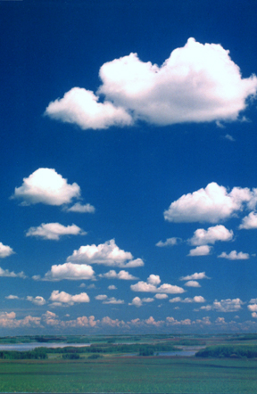


How clouds form and what they contain
Air can hold water vapor in invisible form; when that vapor cools or is concentrated it becomes saturated and begins to condense onto tiny particles such as dust, salt or soot. Condensation produces microscopic droplets or, at lower temperatures, ice crystals. The change from vapor to liquid or solid releases latent heat, which influences cloud development and stability. The physical processes are summarized by the generic term condensation.
Common mechanisms that make air cool and form clouds
- Convection: Sun-warmed air near the surface rises and cools with height; this can produce puffy cumulus clouds.
- Frontal lifting: Warmer air is forced up over colder air along weather fronts and may form layered clouds and precipitation; fronts are a primary cause of widespread cloud bands and rain (rain).
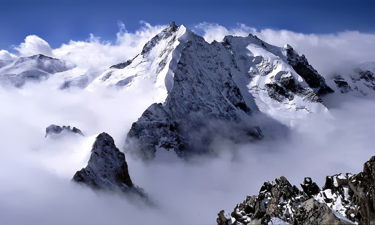
- Orographic uplift: Air that ascends a mountain cools and often forms clouds on the windward side — a process sometimes called mountain lifting.
- Advection over cold surfaces: Warm, moist air passing over a cold body such as an icy lake or chilled ground can lose heat and condense (see lake effects).
Structure, mass and microphysics
Individual cloud droplets are extremely small—typically tens of micrometres in diameter—and numbers of droplets per cubic metre can be large. Although a cloud can contain millions of tons of water in total, the water is dispersed: a cubic metre of a typical cloud contains only a few grams of liquid or ice. Droplets and crystals are heavier than the surrounding air but remain aloft because of buoyant air motions and turbulence. When droplets grow large enough by collision and coalescence or ice processes they fall as precipitation. The conversion from vapor to droplets releases heat; that latent heat affects atmospheric stability and circulation, and is central to storm dynamics and convective growth (mass and energy, droplet physics).
Types of clouds and visual characteristics
Meteorologists classify clouds by height and form. Major groups include:
- High clouds (cirrus, cirrostratus, cirrocumulus): thin, wispy ice-crystal clouds often above 6 km.
- Middle clouds (altostratus, altocumulus): composed of liquid droplets or mixed-phase ice at intermediate levels.
- Low clouds (stratus, stratocumulus): layered or patchy clouds close to the surface, commonly composed of liquid droplets.
- Vertical clouds (cumulus, cumulonimbus): clouds with strong vertical development; cumulonimbus commonly produce heavy rain, thunderstorms and sometimes hail or tornadoes.
Roles, importance and notable facts
Clouds are central to the climate system: they reflect incoming sunlight, trap outgoing infrared radiation, and redistribute heat and moisture. Their net effect on surface temperature depends on altitude, thickness and particle composition. Clouds also provide visible cues used in weather forecasting and aviation safety. Many striking visual phenomena—silver linings, colorful sunsets and rainbows—arise from scattering, diffraction and refraction of light by droplets or ice. Dust and aerosols influence cloud color and formation, and human activities that change aerosol concentrations can modify cloud properties. For practical resources and observational guides see ice crystal processes and general cloud references at water on Earth.
Observation and measurement
Clouds are studied using surface observations, balloons, aircraft, radar and satellites. Remote sensing provides global records of cloud frequency and type, which are vital for climate models and weather prediction. Understanding cloud microphysics and dynamics remains a significant scientific challenge because small-scale processes influence large-scale outcomes. For more technical summaries and data access consult meteorological and climate services using authoritative portals such as evaporation studies and specialized resources at precipitation research and water cycle.


Physics and chemistry of clouds
Components
A cloud consists of aerosol, a collection of finely dispersed particles in the gas mixture of the air (not water vapour, this is a gas and just as invisible as the rest of the air). Only after cooling below a certain temperature - the dew point - tiny water droplets form from the water vapour, and at high altitudes also tiny, floating ice crystals.
The diameter of the liquid droplets is typically in the range of two to ten micrometers, but can also be much larger, up to two millimeters, especially in rain clouds. Large drops and the even much larger hailstones can only form when strong updrafts counteract gravity.
Education, development and resolution
Cloud formation refers to the process of cloud formation by condensation or resublimation of water vapour at condensation nuclei in the troposphere and partly also stratosphere. With the change in temperature (density) and humidity of an air mass, clouds form or dissolve. This can happen for example through
- Lifting processes in the atmosphere during the passage of cold and warm fronts, which transport air masses to higher layers and cool them there (e.g. in the jet stream),
- Thermal updrafts or slope updrafts,
- Supply of colder air masses,
- Supply of more humid air masses.
A visible cloud is formed when the conditions for the formation of stable water droplets or crystals are met. The water absorption capacity of the air is less important than the ratio of condensation and evaporation. At the surface of the water droplet within a cloud, there is a constant exchange of water molecules between the surrounding air and the droplet: Only if more water molecules attach to the droplet than leave it at the same time, i.e. only if the condensation rate is higher than the evaporation rate, can a droplet grow and thus lead to cloud formation. Whether this can happen depends essentially on two variables:
- From the number of water molecules surrounding the droplet: the more water vapour molecules surround the droplet, the more likely it is that one will stick to the droplet. The number of water vapour molecules can be expressed by the so-called water vapour partial pressure, which is the proportion of the total air pressure that is created by the water vapour.
- From the temperature of the water droplet: the warmer the droplet, the easier it is for water molecules to detach from the droplet.
The formation of a cloud is thus favoured by low temperatures and by a large number of water molecules or by high water vapour pressure, which is synonymous with high relative humidity.
The temperature at which condensation and evaporation balance each other out is called the dew point temperature. If this temperature is undershot, stable droplets form and grow under certain conditions. This temperature depends on the respective water vapor pressure. The height of this event in the atmosphere is called the cloud condensation zone. The water vapor pressure at which condensation and evaporation are in equilibrium is called the saturation vapor pressure. It depends on temperature and is also determined by curvature and solution effects.
Drop formation in the Earth's atmosphere only occurs when a sufficient number of condensation nuclei are present. Such nuclei can be, for example, dust particles, but also larger molecules, pollen or - at the sea - salt crystals (see aerosol).
Over the oceans, dimethyl sulfide (DMS), which is formed during the decomposition of algae, is often responsible for cloud formation.
Even at temperatures below 0 °C, a large proportion of the cloud droplets can still be in the liquid state. When the temperature drops to about -12 °C, ice crystals usually do not form, so that the cloud consists of so-called supercooled water droplets. Likewise, dissolved substances within the droplet can cause a reduction in the condensation temperature due to the lowering of the freezing point. With a further drop in temperature, the ice content continues to increase until, at about -40 °C, only ice crystals are present. At higher altitudes, cloud formation is therefore characterised by crystallisation processes.
Droplets sink very slowly because of their small size - about 1 to 15 μm or 0.001 to 0.015 mm. Because their diameter is small, their Reynolds number is less than 0.1, so laminar flow is present. According to Stokes' law, the sinking velocity increases with the square of the diameter. A droplet with a diameter of 0.020 mm sinks about 1 cm per second. The sinking speed can reach values of up to 15 cm/s. It is a purely aerodynamic value. To be distinguished from it is the fall velocity. It results from the difference between the speed of the upwind or downwind and the sinking speed. Because the velocity of the upwind and downwind is much greater than the sinking velocity of the droplets, the fraction of the sinking velocity is usually insignificant. Because clouds are often formed by convective updrafts, they do not fall but remain at the same height or rise (for example, the cumulus). In rain clouds, the drops are much larger (up to 3 mm) and thus the falling speed is also higher (for 1 mm drops approx. 1.8 m/s). For this drop size, the calculation according to Stokes is no longer valid. The drops deform like umbrellas due to their air resistance. If a threshold value is exceeded so that the updraft can no longer compensate for the sinking, it begins to rain. In the case of hail, very strong updrafts and downdrafts occur, which cause the hailstones to rise and sink again several times, their diameter growing layer by layer.
In meteorology, clouds are distinguished by shape and height above the ground. A cloud near the ground is called a fog, but even if they differ only in position, fog is not considered a cloud type. In a broader sense, however, cloud formation is also understood to include the formation of other cloud types, such as dust clouds or methane clouds, although this is not limited to the Earth and also includes cloud formation on other celestial bodies.
Significance for the radiation budget
Clouds have a great influence on the Earth's radiation budget and thus also on the air temperature, especially over the course of the day, but also on long-term climatic averages. This is particularly noticeable in summer. As soon as a cloud cover forms during the day and shields the solar radiation, i.e. the global radiation decreases, the solar energy available for heating the air also decreases and it quickly becomes noticeably colder. However, this cloud cover also reflects a certain amount of the terrestrial radiation back to the ground. Consequently, on a clear night it becomes much colder than on an overcast night, since the terrestrial heat radiation can escape into space and is hardly retained by the water vapor contained in the atmosphere.
These effects can be observed especially in deserts, where clouds are usually rare: Much more heat is radiated at night than in more humid zones. The temperature differences between day and night are therefore also much higher.
An important property of clouds is their optical thickness. It determines how much solar radiation can penetrate a cloud cover and how much, on the other hand, is absorbed or reflected. The determining factors are the vertical extent of the cloud, the distribution of the droplet or ice crystal sizes and finally the quantity and distribution of the clouds themselves. Clouds are somewhat more transparent to short-wave UV radiation than to the wavelengths of visible light. The scattering of the direct solar radiation by the air particles causes their decreasing share with decreasing height and thus favours this effect. The additional scattering by the cloud droplets also increases the photon pathways, which favours absorption by ozone and reduces the transmission of light. In terms of UV radiation, absorption by the water droplets themselves is negligible as long as they are not too contaminated (for example, by a volcanic eruption). On a global scale, this means that on a long-term average, clouds directly reflect 20 percent of the short-wave solar radiation and at the same time absorb three percent.
However, as shown in the first paragraph, the effect of clouds in the radiation budget is not solely linked to their properties, but is based on the interaction of many different factors. Particularly important is the effect of the long-wave radiation of the earth's surface in conjunction with the atmospheric counter radiation. This effect is the actual cause of the atmospheric greenhouse effect and plays an important role in global warming. The radiation of the Earth's surface is a consequence of the absorption of direct and diffuse solar radiation by the Earth's surface and depends on its surface temperature. The optical thickness of clouds, which in turn determines global radiation, is now largely responsible for how much of this terrestrial radiation is absorbed in the atmosphere and re-radiated back to the Earth's surface, with multiple reflections occurring between the cloud base and the Earth's surface as often as desired. This atmospheric counter-radiation increases the radiation directed towards the Earth's surface and thus partially compensates for the shielding effect of the clouds.
How large this offset is in terms of large areas and long time periods is difficult to determine, which is why it is also a central question in climate modeling.
Role in the water cycle
Clouds act as a mediator between evaporation and precipitation in the hydrological cycle. Although the water they contain is quite insignificant in terms of quantity in relation to the Earth's water resources, they convert water quickly.


Appearance
The appearance of a cloud is primarily determined by the type, size, number and spatial distribution of its components. It also depends on the intensity and colour of the light incident on the cloud and on the respective position of the observer and light source in relation to the cloud. The appearance of a cloud is best described in terms of size, shape, coarse and fine structure, brightness and colour.
Shape and structure
Clouds can sometimes take on strange shapes that the human eye can associate with things from everyday life. Especially with stronger winds, which make the clouds fray and form and deform again and again, you can "see" many things.
Brightness
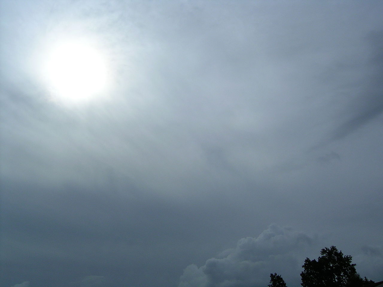
The brightness of a cloud is determined by the light reflected, scattered and transmitted by its particles. This light usually represents direct or diffuse solar radiation, but it can also come from the moon or the earth's surface. Especially due to the large albedo of ice and snow surfaces, the perceived brightness of clouds can increase because of the backscattered light.
The effect of haze or special light phenomena of atmospheric optics, such as halos, rainbows, coronae and glories, among others, also changes the cloud brightness. If haze is between the observer and the cloud, the brightness of the cloud can be increased or decreased depending on the density of the cloud and the direction of the incident light. Haze also weakens the contrasts that make the shape and the coarse and fine structure of the cloud visible.
During the day the brightness of the clouds is such that they can be observed without difficulty. On nights with moonlight, the clouds can be seen when the moon phase is more than a quarter. During the darker phases, the moonlight is not bright enough to allow distant clouds to be seen. This is especially true when the clouds are thin. On moonless nights, clouds are generally not visible, but one can sometimes infer the presence of clouds based on the occultation of stars, aurora, zodiacal light, or other effects.
In areas with sufficiently strong artificial lighting, clouds are also visible at night. Therefore, over large cities, clouds are visible as a result of the direct illumination coming from below. Such an illuminated cloud layer can then form a bright background against which lower cloud parts stand out vividly and darkly.
Color
The color of a cloud depends on the wavelength of the light that illuminates the cloud. The cloud itself cannot change the color because the droplet size in clouds is larger than the wavelength of the light (about 1 μm to 15 μm) and therefore the statements of Rayleigh scattering do not apply. This is especially true for clouds up to about 20 km distance, because then there are too few air molecules to be able to cause color changes.
If there is haze or dust between the observer and the cloud, this can slightly change the colour of the cloud. Therefore, for example, very distant clouds may appear slightly yellow or orange.
- If the sun is high enough, the clouds or parts of them appear white or grey in direct sunlight.
- Those parts that receive light preferentially from the blue sky have a blue-grey appearance.
- When the sun approaches the horizon, i.e. at sunrise and sunset, its colour can change from yellow to orange to red, because the very long path of the light through the earth's atmosphere scatters a large part of the high-frequency light components (blue) to the side (see Rayleigh scattering). Most of the light with long wavelengths remains and the colour impression of the sun shifts strongly towards red. The sky around the sun and the clouds can only reproduce this colouring.
The cloud colours also depend on the height of the clouds as well as their respective position to the observer and to the sun. If the sun is close above or below the horizon, the high clouds can still look almost white, while the medium-high clouds show a strong orange or red colour. Very low clouds, lying in the earth's shadow arc, look grey. These colour differences give an idea of the respective cloud height. Clouds at the same altitude level looking towards the sun appear less red in colour than those looking in the opposite direction. At night, the brightness of clouds is usually too low to distinguish colors, and all perceptible clouds then appear black to gray, except those illuminated by the moon, which have a whitish appearance. Special lighting conditions, such as fires, big city lights, or aurora borealis, can sometimes give some clouds a more or less distinct color at night.


Questions and answers
Q: What is a cloud?
A: A cloud is water vapour in the atmosphere (sky) that has condensed into very small water droplets or ice crystals that appear in visible shapes or formations above the ground.
Q: How does a cloud form?
A: Clouds form when the atmosphere can no longer hold all the invisible air vapor. Any more water vapor condenses into very small water drops. Warm air holds more water vapor than cool air, so if warm air with lots of water inside cools, it can form a cloud. These are ways air can cool enough to form clouds: when air close to the ground is heated by the sun and rises to where the air is colder; along weather fronts warmer air is cooled as it runs into colder air; when air goes up the side of a mountain it cools as it goes higher; when warm air goes over something colder (such as cool water in a lake) or ground that is cooled at night it cools.
Q: How heavy are clouds?
A: Clouds are heavy - The water in a cloud can have a mass of several million tons and every cubic metre (m3) of the cloud has only about 5 grams of water in it. Cloud droplets are also about 1000 times heavier than evaporated water, so they are much heavier than air. They do not fall, but stay in the air because there is warm air all round them which helps them "stick".
Q: Why do some clouds appear brilliant colors at sunrise or sunset?
A: This is due to dust particles in the atmosphere reflecting light from different angles which causes them to look like brilliant colors at sunrise or sunset.
Q: What happens after rain falls back down to earth?
A: After rain falls back down to earth, then the cycle starts again - The water evaporates again and this process is called “the Water Cycle”.
Q: What keeps clouds suspended in mid-air?
A:The heat generated from changing from gas to droplets helps keep clouds suspended mid-air because these tiny droplets stick onto warm pockets of surrounding warm airs which prevents them from falling down towards Earth's surface
Related articles
Author
AlegsaOnline.com Cloud (meteorology): formation, types, and roles in the water cycle Leandro Alegsa
URL: https://en.alegsaonline.com/art/21107
Sources
- ntrs.nasa.gov : "The identification of cloud types in LANDSAT MSS images"
- srh.weather.gov : "NWS JetStream MAX - The Structure of the Ionosphere"
- vortex.plymouth.edu : "Plymouth State Meteorology Program Cloud Boutique"