
Canton of Clervaux
Northern Luxembourg canton centered on the town of Clervaux (Klierf). A rural, hilly district in the Oesling with forests, border crossings, historic sites and outdoor recreation.
Overview
The Canton of Clervaux is a political and geographic subdivision in northern Luxembourg. Its administrative centre is the town of Clervaux (Klierf in Luxembourgish). The canton occupies part of the Oesling highlands and is noted for sparse settlement, woodlands and a generally rural character. For general location reference see the coordinates 50°04′N 6°02′E.
Image gallery
1 Image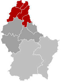
Geography and environment
Clervaux lies in the northern uplands of the country with rolling hills, plateaus and river valleys. The landscape is dominated by mixed forests, pastures and small farms. Its position near the Belgian and German frontiers gives the canton a cross-border dimension: roads and footpaths connect communities across the borders and pockets of protected natural areas are popular for hiking and wildlife observation.
Administration and communes
The canton is organised into local communes that manage municipal services and planning. Notable communes include Clervaux itself, Troisvierges, Wincrange, Weiswampach and Parc Hosingen; each commune comprises villages and hamlets with local councils responsible for schools, roads and cultural activities. The canton functions as an intermediate tier of government within the Grand Duchy and is one of Luxembourg’s more rural administrative units.
History and culture
Clervaux has medieval roots visible in village layouts and surviving fortifications. The town’s castle is a cultural landmark and hosts a significant photographic exhibition, attracting international visitors. In the 20th century the area was affected by fighting during the final stages of World War II; memorials and museums record those events and their local impact.
Economy, tourism and notable sites
The local economy relies on agriculture, forestry and small-scale services, while tourism is important seasonally. Visitors come for heritage sites, forest walks, cycling routes and rural hospitality. Points of interest include historic villages, castle exhibitions and scenic valleys; the canton’s quiet roads and trails are a draw for outdoor recreation and cultural tourism.
Practical information
- Administrative seat: Clervaux.
- Context: part of Luxembourg’s Oesling region and a borderland near Belgium and Germany.
- Further reading: regional guides, municipal pages and national resources provide details on services, events and conservation plans; see local commune websites and tourism offices for up-to-date information (canton resources).
For maps, municipal contacts and statistical summaries consult official regional portals and local town halls. Additional reference material on the canton’s heritage and visitor attractions is available through national cultural repositories and tourism services (local information).
Questions and answers
Q: What are the coordinates of Clervaux?
A: The coordinates of Clervaux are 50°04′N 6°02′E / 50.067°N 6.033°E / 50.067; 6.033.
Q: What language is spoken in Clervaux?
A: Luxembourgish is spoken in Clervaux.
Q: What is the capital city of the canton of Clervaux?
A: The capital city of the canton of Clervaux is also called Clervaux.
Q: How many cantons does Luxembourg have?
A: Luxembourg has twelve cantons in total, including the canton of Clervaux.
Q: Is there a river running through the town of Clervaux?
A: Yes, there is a river called the Sûre that runs through the town of Clervaux.
Q: Does Luxembourg have an official language?
A: Yes, Luxembourg has three official languages - French, German and Luxembourgish - with French being predominant in government and administration use while German and Luxembourgian are spoken by most people living in Luxembourg.
Related articles
Author
AlegsaOnline.com Canton of Clervaux Leandro Alegsa
URL: https://en.alegsaonline.com/art/20936
Sources
- commons.wikimedia.org : Canton of Clervaux
- statistiques.public.lu : "Surface area of the cantons and municipalities"
- statistiques.public.lu : "Population by canton and municipality 1821 - 2017"