Cime du Gélas (Monte Gelàs) — high peak of the Maritime Alps
Cime du Gélas is a 3,143 m mountain on the France–Italy border, the highest summit in Mercantour National Park and Alpes‑Maritimes; notable for its twin summits, alpine habitats and shrinking snowfields.
Overview
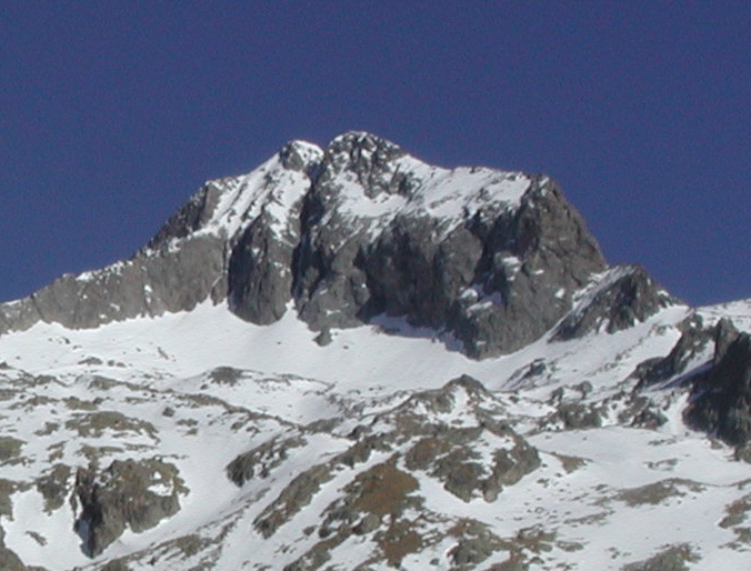
Cime du Gélas (Italian: Monte Gelàs) reaches an elevation of about 3,143 metres and stands on the main watershed between France and Italy. The mountain is a landmark of the Maritime Alps and can be located on regional mapping and peak databases (map and data). Its profile is compact and rocky, forming a distinct summit visible from several surrounding valleys, and it offers wide views toward lower alpine ranges and, in clear weather, toward the Mediterranean basin.
Image gallery
5 Images


Location and protected status
The summit lies on the administrative frontier that separates the French region of Provence‑Alpes‑Côte d'Azur from territory administered on the Italian side by the area around the Province of Cuneo. On the French flank the mountain is the highest point of the Mercantour protected area, managed as the Parc national du Mercantour, and it is the loftiest feature of the Alpes‑Maritimes department. The Italian slopes belong to the Maritime Alps Natural Park (Parco naturale delle Alpi Marittime), so the massif is part of a cross‑border network of conservation lands.
Physical characteristics
Gélas consists of two close summits of similar height, forming a compact massif rather than an extended ridge; the western summit is generally regarded as the main top. Historically the mountain supported small glaciers and perennial snowfields, but these have markedly retreated in recent decades. The bedrock shows the metamorphic and crystalline composition typical of the Maritime Alps, producing steep faces, rocky ledges and scree slopes at high elevation.
Geology and climate
The mountain is part of the alpine chain created by continental collision; long periods of glacial erosion, frost action and mass wasting have sculpted its cirques and arêtes. The climate at summit level is alpine: summers are short and can produce sudden storms, while winters are cold with persistent snow at higher elevations. Rapid changes in temperature and frequent high winds make mountain weather unpredictable.
Flora, fauna and ecosystems
Cime du Gélas lies within a transition zone where Mediterranean influences meet true alpine environments. Vegetation includes specialized alpine and subalpine communities — cushion plants, hardy grasses and small flowering species adapted to extreme conditions. The surrounding protected parks shelter mammals and birds typical of high mountains; observers report chamois and raptors among the fauna of the area. The combination of habitat types contributes to notable biodiversity and several locally rare species.
Routes and mountaineering
The mountain attracts hikers, scramblers and mountaineers from both countries. Approaches are available from valleys on the French and Italian sides; difficulties range from steep, exposed hiking to short sections of rock scrambling. Good route‑finding, appropriate equipment and awareness of sudden weather changes are essential. Guided ascents and detailed route descriptions may be found through local guide services and alpine clubs.
Conservation and research
- Cime du Gélas is the highest summit within the Mercantour National Park and the Alpes‑Maritimes department, and it lies within cross‑border conservation frameworks linking French and Italian parks.
- Remnants of glacial ice and perennial snow have diminished, a local example of wider trends in alpine glacier retreat that are monitored by researchers.
- Protected status supports habitat preservation, scientific monitoring and sustainable mountain tourism across the border between France and Italy.
History and cultural notes
Human interactions with the massif have long included pastoral use, seasonal travel and early exploratory climbs by local hunters and mountain guides. Formal records of first ascents are often fragmentary, but the peak entered the attention of 19th‑ and 20th‑century alpinists as interest in the Maritime Alps grew. Today the mountain continues to be valued for its natural qualities, scientific interest and role in cross‑border conservation.
For practical information and current conditions consult dedicated mapping resources and local park authorities (mapping and data, Parc national du Mercantour, or regional offices linked to the Province of Cuneo and the Provence‑Alpes‑Côte d'Azur authorities).
Questions and answers
Q: What is Cime du Gélas?
A: Cime du Gélas is a mountain on the boundary between France and Italy, with a height of 3,143m.
Q: Where is Cime du Gélas located?
A: Cime du Gélas is located on the boundary between France (Provence-Alpes-Côte d'Azur region) and Italy (Province of Cuneo).
Q: What is the height of Cime du Gélas?
A: Cime du Gélas has a height of 3,143m or 10,312ft.
Q: What is the significance of Cime du Gélas?
A: Cime du Gélas is the highest peak of the Mercantour National Park and of the Alpes-Maritimes department.
Q: What is the name of the Italian side of Cime du Gélas?
A: On the Italian side, Cime du Gélas is part of the Maritime Alps Natural Park or Parco naturale delle Alpi Marittime in Italian.
Q: Which region of France is Cime du Gélas in?
A: Cime du Gélas is in the Provence-Alpes-Côte d'Azur region of France.
Q: Which department in France has the highest peak of Cime du Gélas?
A: Cime du Gélas is the highest peak of the Alpes-Maritimes department in France.
Tags
Related articles
Author
AlegsaOnline.com Cime du Gélas (Monte Gelàs) — high peak of the Maritime Alps Leandro Alegsa
URL: https://en.alegsaonline.com/art/20383
Sources
- peakbagger.com : "Cime du Gélas, France"
- peakware.com : "Cime du Glas"