Chirripó National Park — Costa Rica’s highland wilderness
Protected area in the Talamanca Range of Costa Rica, containing Cerro Chirripó, diverse montane habitats, important water sources, endemic species, and regulated trails to the country's highest peak.
Overview and location
Chirripó National Park is a protected area in southern Costa Rica that conserves a significant portion of the Talamanca Range and the country's highest mountain. The park is described in official materials and visitor guides: park overview. It lies within Costa Rica's national territory and is often approached from regional towns and trailheads identified in travel summaries: country guide, approach route, distance reference, local services. Chirripó is also linked administratively and ecologically to neighboring protected areas: La Amistad connection.
Image gallery
3 Images

Physical geography and notable features
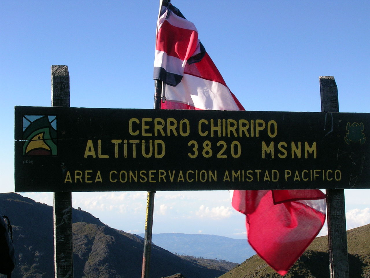
The park protects steep ridgelines, cloud forest, montane woodlands and high-elevation grasslands. Established in the mid-1970s to conserve headwaters and fragile ecosystems, the protected area covers more than fifty thousand hectares: see official area descriptions at area figures, hectare detail and acre equivalence. Its most prominent landmark is Cerro Chirripó, the country's highest summit, whose elevation is recorded in geographic summaries: highest mountain note, Cerro Chirripó, elevation data, altitude conversion. On clear days visitors report distant views toward both the Pacific and the Caribbean coasts.
Name, hydrology and climate
The name Chirripó is commonly translated from local indigenous languages as "Land of Eternal Waters," a reference to the area's many springs and headwaters. The park contains source areas for streams and rivers that feed both Caribbean and Pacific drainages; hydrological information is summarized at indigenous name, language note, river networks. Weather in the highlands is variable and strongly influenced by elevation and exposure; general climatic patterns and best visiting seasons are described at weather patterns. Temperatures can fall sharply overnight: historic low records and related notes appear at temperature records, low temperature report, while seasonal advice for visitors is available at seasonal advice.
Habitats, flora and fauna
Elevation gradients produce a mosaic of habitats from lower montane rainforests through cloud forest to high-elevation shrub and grassland. The park supports large trees, abundant epiphytes and a rich orchid flora; botanical overviews and lists can be consulted at seasonal guide, habitat types, notable trees. Notable tree groups include mature oaks, members of podocarp families and other highland associates that form distinct canopy layers: see species notes at tree species.
- Plants: abundant epiphytes, mosses and lichens together with many orchid species; more information is compiled at orchid diversity.
- Mammals and amphibians: a range of montane-adapted mammals and amphibians occur here; inventory and observation records are available through regional wildlife pages: mammal records, regional fauna, small mammals.
Wildlife highlights
Wildlife in Chirripó includes both common highland species and rarer or wide-ranging animals. Observers have reported carnivores and larger felids in the broader Talamanca landscape—references and cautionary notes on distribution appear at carnivore notes, large cat presence. Smaller terrestrial mammals such as squirrels and rabbits are present: see small mammals. Birdlife is especially notable for montane specialists and migratory visitors; the resplendent quetzal and other emblematic species are documented in bird lists and guides: bird lists, quetzal notes. Amphibian diversity is significant in moist forest patches and highland streams: consult herpetofauna summaries at frog records and related resources.
History, exploration and access
Human use of the Talamanca highlands predates the park, and recorded climbs and natural history visits date from the early 20th century. Early ascent and expedition notes are preserved in historical summaries: first ascent note, expedition chronology, early records. The national park was created in 1975 to protect headwaters and biological connectivity. Today maintained trails and ranger stations provide regulated access; practical trail and permit information can be found at trail information, explorer notes, ascent records.
Visiting, safety and practical advice
Climbers and hikers planning a visit should prepare for rapid weather changes, strong sun at elevation, and cold nights. Many visitors reserve refuges and permits in advance and follow recommended itineraries to minimize environmental impact; practical guidance and reservation details appear at official and visitor resources such as seasonal advice, trail information, local services. Respecting park rules and the advice of rangers helps protect fragile habitats and ensures safety.
Conservation, research and regional importance
Conservation priorities for Chirripó include protection of water supplies for downstream communities, preservation of habitat connectivity with La Amistad International Park, and safeguarding endemic and high-elevation species. The park is a focus for ecological research, biodiversity monitoring and community-based conservation initiatives; summaries of conservation measures and research programs are available at La Amistad connection, area figures, species notes, mammal records.
Further reading and resources
For updated regulations, maps and field guidance consult official park pages and regional conservation organizations: park overview, national guide, botanical summaries, tree guides, fauna listings. Field research, visitor planning and conservation work benefit from the coordinated information provided by these sources.
Questions and answers
Q: What is Chirripó National Park?
A: Chirripó National Park is a national park in Costa Rica located in the Talamanca Mountain, 20 km northeast of San Isidro de El General. It was created on August 19, 1975 and has an area of 50,150 ha (123,923 acres).
Q: What is the highest mountain in Costa Rica?
A: The highest mountain in Costa Rica is Cerro Chirripó with an altitude of 3,920 m (12,861 ft).
Q: What does "Chirripó" mean?
A: In the indigenous language, "Chirripó" means Land of Eternal Waters.
Q: What kind of animals can be found in this region?
A: The most common animals found in this region are coyotes, jaguars, squirrels, frogs, rabbits and quetzals.
Q: When was Mount Chirripó first climbed?
A: The first person known to climb Mount Chirripó was the priest Agustin Blessing in 1904.
Q: What kind of habitats can be found within the park?
A: There are many habitats within the park due to differences in altitude and climate. These include large trees like oak and sweet cedar as well as different types of orchids.
Q: When is it recommended to visit the park? A: It is recommended to visit the park during its warm season from December to May.
Related articles
Author
AlegsaOnline.com Chirripó National Park — Costa Rica’s highland wilderness Leandro Alegsa
URL: https://en.alegsaonline.com/art/19836
Sources
- sinaccr.net : < the original