Chile: geography, people, history and notable features
Comprehensive overview of the Republic of Chile: its geography, climate zones, population and culture, economic highlights, historical outline and distinguishing facts.
Overview
The Republic of Chile is a long, narrow country running along the southwestern edge of South America. Its territory stretches more than 4,200 kilometers from north to south and faces the Pacific Ocean on the west. For maps and basic reference see location resources and general material about the continent. The Spanish language is the national and most widely spoken tongue in Chile (Spanish).
Image gallery
10 Images


Geography and climate
Chile's unusual shape produces extreme geographic variety in a relatively narrow band. In the north lies the Atacama Desert, among the driest non-polar regions on Earth and a focus for astronomical observatories; for further reading see Atacama. Central Chile contains a fertile valley and a Mediterranean-type climate that supports agriculture and vineyards; climate summaries are available at Mediterranean climate. To the south the landscape gives way to temperate rainforests, fjords and glaciated mountains. Chile also administers remote Pacific islands and asserts a territorial claim in Antarctica; background material can be found at Antarctic claim.
Population, society and language
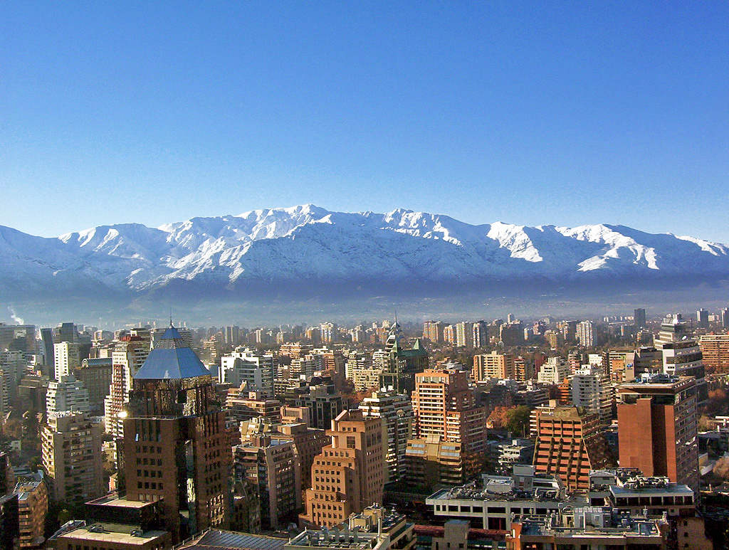
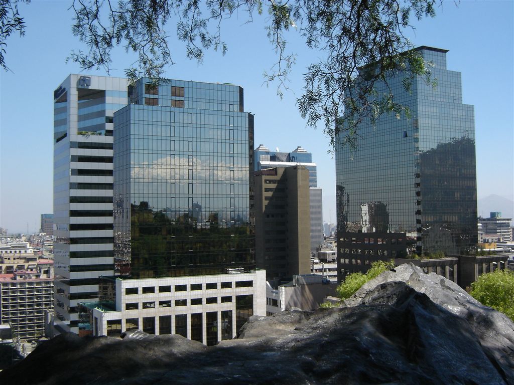
Most of Chile's population lives in the central region, clustered around the capital and the nearby coastal city; metropolitan centers are described in sources on Santiago and Valparaíso. Literacy and basic educational attainment are relatively high for the region. The population has diverse origins: many Chileans have mixed indigenous and European ancestry and there are notable communities with roots in various parts of Europe and elsewhere. Broad ethnic categories and migration influences are discussed in materials linked to European descent, German immigration, English and other European arrivals, and populations of Arab origin. Indigenous peoples and their histories are represented under Native American topics. Religious life is mixed: Roman Catholicism is the largest single affiliation, with Protestant groups and small Jewish communities mentioned in resources on Jews.
History and economy
Chile's modern state was shaped by Spanish colonial rule followed by independence movements in the early 19th century. Over the 20th and 21st centuries the economy has diversified beyond farming to include large-scale mining (especially copper), forestry, fishing, manufacturing and services. Chile is a prominent producer of copper and agricultural exports such as fruit and wine. Urbanization, education and trade openness have been important themes in the country's recent economic development.
Culture, cuisine and notable facts
Chilean culture blends indigenous, Spanish and later immigrant influences. The country has produced internationally recognized writers and poets and has a lively tradition of music, visual arts and film. Chilean cuisine emphasizes seafood, corn, potatoes and regional cheeses; spicy ingredients such as chili peppers appear in dishes worldwide, though their deep origins are continental rather than uniquely Chilean. Public celebrations, local crafts and regional customs vary from north to south.
Quick facts and distinctions
- Official name: Republic of Chile.
- Capital: Santiago; major coastal port: Valparaíso (more on cities).
- Official language: Spanish (Spanish).
- Currency: Chilean peso.
- Geographic extremes: extremely long north–south extent, from hyper-arid desert to glacial southern zones; see Atacama and Antarctic references.
- Demographics: mixed indigenous and European ancestry with immigrant communities from Germany (German), Britain (English), Italy and other countries; Arab and other diasporas are noted (Arab).
For introductory or in-depth reading consult general country profiles and the various thematic links above for geography, culture, demographic composition and environmental zones.


Etymology
The origin of the word Chile is not clearly established. The most common explanation is that the word derives from the Aymara language. There, the word chilli means "land where the world ends". This would be supported by the fact that the first Spaniards to arrive in Chile set out from Aymara settlement areas. Since the beginning of the colonization of South America, the Spanish referred to the land south of the Atacama Desert by the name Chile. Chilean schools also teach the variant that Chile could be the onomatopoeic name of a bird called Trile.
Another, less widespread theory cites the Inca language Quechua as the origin. The maximum extent of the Inca Empire reached to the area of today's Santiago, whereupon the Inca called the land south of the Río Aconcagua tchili, meaning snow, in reference to the relatively cold climate and the snow-covered Andes.
However, it is certain that the name Chile is not derived from the chilli pepper (of the same name in Spanish). This word comes from the Central American Aztec language Nahuatl. The chili (and the salsa made from it) is called ají in Chilean Spanish (see also: Examples of differences in vocabulary).
Physical geography
→ Main article: Physical geography of Chile
Chile extends on the South American continent over 4275 kilometers in north-south direction along the Andes and the Pacific Ocean (if you count the Antarctic part, about 8000 kilometers), but is on average only about 180 kilometers wide. The narrowest point in continental Chile (without Antarctica) is 90 kilometres, the widest point about 440 kilometres. The longitude of Chile corresponds to the distance between the middle of Denmark and the Sahara in Europe and Africa.
Due to the long north-south extension over more than 39 degrees of latitude, but also the considerable differences in altitude in west-east direction, Chile has a great variety of climatic and vegetation zones.
Plate tectonic situation
Chile lies at the boundary of several lithospheric plates: The Nazca Plate subducts under the South American Plate as far as the Gulf of Penas, and the Antarctic Plate subducts south of it as far as the Strait of Magellan at a slower rate. Through the Strait of Magellan runs in an east-westerly direction the boundary between the South American and the Scotia Plates.
This is the cause of the pronounced volcanism in Chile and the regularly occurring, sometimes massive earthquakes. The first documented earthquake was the great Concepción earthquake in 1570, and the 1960 Valdivia earthquake, whose tsunami caused severe damage throughout the circum-Pacific region, was the earthquake with the largest magnitude ever recorded in the world. On February 27, 2010, a massive earthquake measuring 8.8 Mw on the moment magnitude scale struck southern Chile, destroying much of Chile's infrastructure. Central Chile was also severely affected. In Region VI and VII, high tsunami waves hit after about 20 minutes, destroying entire coastal towns and areas. Even weeks after the earthquake, the country was shaken by many aftershocks. Overall, regions III to IX were affected in Chile.
→ See also: List of earthquakes in Chile
Relief geology
Simplified, central and southern Chile consists of two parallel mountain ranges running north-south: the Andes to the east and the lower coastal mountain range (Cordillera de la Costa) to the west. In between lies the Central Valley (Valle Central or Valle Longitudinal), with the bulk of the population, farmland, and viticulture. The elevation of the Cordillera, Central Valley, and Andes decreases on average from north to south, so that the Central Valley dips below sea level south of the city of Puerto Montt, which is about 1000 kilometers south of Santiago. The coastal cordillera, of which only the mountain peaks rise out of the water, simultaneously becomes a chain of islands. In this region, therefore, a unique fjord and island landscape can be discovered. In the north of Chile, on the other hand, there is no distinct central valley, i.e. the landscape first rises steeply coming from the coast and then forms with the Pampa del Tamarugal an approximately 1000 to 1500 metre high plateau up to the foot of the Andes.
The Chilean Andes, which only in a few places fall below the 2000-meter altitude line, are divided into four larger blocks from north to south in terms of their geological-tectonic structure.
- In the Great North (Norte Grande) of the country, an approximately 1000 kilometre long chain of recent stratovolcanoes stretches from the border with Peru (at about the 17th southern latitude) to the highest mountain of the country, the dormant volcano Ojos del Salado (6893 m), which lies south of the 27th latitude at about the height of the city of Copiapó.
- In the Little North (Norte Chico) between the 27th and 33rd parallel, which runs slightly north of the capital Santiago de Chile, is the high Cordillera, averaging 5000 m in height, which is free of recent volcanism.
- From Santiago de Chile over the entire Little South (Sur Chico) to a little south of the city of Puerto Montt (42nd latitude), the 6550 m high volcano Tupungato again starts a long volcanic chain, which, however, quickly loses height to the south.
- In the Great South (Sur Grande), which extends to the island of Tierra del Fuego, there are only a few isolated volcanoes left, and the altitude of 3000 metres is rarely exceeded. Here the glacial formations with glacial lakes, cirques and fjords dominate the landscape. The Cordillera Darwin mountains form the last large mountain range before the end of South America.
The transition area between the coastal cordillera and the Andes can be divided into two areas: the Pampa del Tamarugal in the north and the Valle Longitudinal in the central and southern area. Both are distinct rift systems. The Pampa del Tamarugal extends directly along the northern volcanic chain, while the Valle Longitudinal, which lies somewhat lower, follows the southern volcanic chain and dips into the sea at Puerto Montt (41° 30′ S).
The coastal cordillera extends with a short interruption south of the island of Chiloé over the entire west side of the country. It rises in the north of the country between Arica and Chañaral (26th parallel) as a steep coast directly to 1000 m above sea level (in places over 2000 m). Since the few rivers in this area do not have the strength to break through due to the extremely arid climate, it is only intersected by a few valleys here. The valley systems accumulate only southward from Chañaral. The coastal mountains flatten out towards the south and finally reach heights above 1000 m in only a few places in the Little South. The coastal cordillera continues from the 44th parallel (Chonos Archipelago) as a chain of islands.
Mountains
The Chilean Andes form one of the highest mountain ranges in the world and have a multitude of peaks over 6000 m. Among them is the highest mountain in Chile, the Ojos del Salado (6893 m), which is also the highest volcano in the world.
Below is a list of Chile's most famous mountains (from north to south):
- Volcán Parinacota, 6342 m, XV region (Región de Arica y Parinacota)
- Volcán Licancábur, 5916 m, II. region (Región de Antofagasta)
- Volcán Llullaillaco, 6739 m, II. region (Región de Antofagasta)
- Nevado Ojos del Salado, 6893 m, III. region (Región de Atacama)
- Cerro Tupungato, 6550 m, Capital Region (Región Metropolitana)
- Puyehue volcano, 2236 m, XIV region (Región de los Ríos)
- Descabezado Grande, 3830 m, VII Region (Región del Maule)
- Volcán Villarrica, 2840 m, IX. region (Región de la Araucanía)
- Volcán Osorno, 2652 m, X. Region (Región de los Lagos)
- Volcán Cerro Hudson, 1905 m, XI. Region (Región de Aisén)
- Cerro Paine Grande, 2800 m, XII. Region (Región de Magallanes y de la Antártica Chilena)
Rivers and lakes
Due to the special structure of the country, there are no longer rivers in Chile. The longest, at 443 kilometres, is the Río Loa in the north in the middle of the Atacama Desert. The rivers that carry water permanently are mostly fed by the melting of snow and ice from the Andes. According to the increasing precipitation, the volume of water carried increases towards the south. The rivers are used for irrigation in agriculture, for energy production and to a lesser extent for tourism. Some rivers from north to south are the following:
- Río Lluta, 167 km, XV Region (Región de Arica y Parinacota)
- Río Lauca, 160 km, XV region (Región de Arica y Parinacota)
- Río Loa, 443 km, II. region (Región de Antofagasta)
- Río Copiapó, 162 km, III. region (Región de Atacama)
- Río Elqui, 170 km, IV. region (Región de Coquimbo)
- Río Choapa, 160 km, IV. region (Región de Coquimbo)
- Río Aconcagua, 142 km, V. Region (Región de Valparaíso)
- Río Mapocho, 120 km, Capital Region (Región Metropolitana)
- Río Maipo, 250 km, Capital Region and V. Region (Región Metropolitana, Región de Valparaíso)
- Río Cachapoal, 172 km, VI. Region (Región O'Higgins)
- Río Maule, navigable, 240 km, VII Region (Región Maule)
- Río Biobío, 380 km, VIII Region (Región del Biobío)
- Río Imperial, navigable, 52 km, IXth Region (Región de la Araucanía)
- Río Valdivia, navigable, 15 km, XIV region (Región de Los Ríos)
Chilean lakes include the salt lakes in the north, the largest and best known of which is the Salar de Atacama (3000 square kilometres). In the far north is the 21.5 square kilometer Lago Chungará at an altitude of about 4500 meters, one of the highest lakes in the world.
Chile's large and most scenic lakes extend southeast from the city of Temuco to Puerto Montt in the following order:
- Lago Colico, 56 km², IXth Region (Región de la Araucanía)
- Lago Caburga, 51 km², IX region (Región de la Araucanía)
- Lago Villarrica, 176 km², IX region (Región de la Araucanía)
- Lago Calafquén, 120 km², IXth Region (Región de la Araucanía) and XIVth Region (Región de Los Ríos)
- Lago Pirihueico, 30 km², XIV region (Región de Los Ríos)
- Lago Panguipulli, 116 km², XIV region (Región de Los Ríos)
- Lago Riñihue, 77 km², XIV region (Región de Los Ríos)
- Lago Ranco, 401 km², XIVth Region (Región de Los Ríos)
- Lago Puyehue, 156 km², X. Region (Región de los Lagos)
- Lago Rupanco, 223 km², X. Region (Región de los Lagos)
- Lago Llanquihue, 860 km², X. Region (Región de los Lagos)
- Lago General Carrera, 970 km², XI. Region (Región de Aisén), the western part of Argentina's Lago Buenos Aires.
Many lakes are navigable.
Natural and climatic structure
Chile is located in the southern hemisphere, which is why the seasons are shifted by half a year compared to the northern hemisphere. The country can be divided climatically into three zones: Northern, Central and Southern Chile.
Northern Chile (called the "great north") has many mountains that are over 6000 m high. Between the coast and the western Andes main chain stretches the Atacama Desert. This desert is one of the driest areas on earth; often no rain falls for years. In the past, the desert was known for its large deposits of saltpetre, whereas today it is mainly copper that is mined there. The largest and most important city in this region is the port city of Antofagasta (310,000 inhabitants).
Central Chile has a climate comparable to the Mediterranean. This region is very fertile and densely populated. Here is the capital Santiago de Chile with about 5.5 million inhabitants. Other important cities are Valparaíso (seaport and parliamentary seat, 280,000 inhabitants), Viña del Mar (popular holiday resort, 320,000 inhabitants) and Concepción (centre of agriculture and industry, 216,000 inhabitants). The area north of Santiago is called "little north", that south of Santiago "little south".
The very sparsely populated southern Chile (called the "big south") is a region with extremely high precipitation. The coast is highly indented by a large number of offshore islands. South of the mainland is the island of Tierra del Fuego, which Chile shares with neighboring Argentina. On the offshore island of Tierra del Fuego, Isla Hornos, is Cape Horn, the southernmost point of Chile and South America.
Special features of the climate
Overall, Chile's climate is strongly influenced by the Humboldt Sea Current along the coast. This flows from south to north and transports cold seawater from the Antarctic. While northern Europe benefits from the warm Gulf Stream, water temperatures in Chile are significantly lower at the same latitude (north/south coordinates). In Punta Arenas (southern Chile) - which is about the same distance from the equator as Hamburg - the average daily temperature in summer is 12 degrees Celsius.
A special feature of the Chilean climate is the El Niño effect, also called the Southern Oscillation. Although this climatic phenomenon mainly affects countries such as Peru or Indonesia, it is also effective in Chile about every seven years and leads to increased precipitation here compared to normal years.
flora and fauna
Flora
Due to the huge extension of over 4000 kilometers, there are many vegetation zones in Chile. In the area of the Atacama Desert little grows. There is vegetation only near the coast or in the area of the Andes. Here grow many different kinds of cacti, succulents and dwarf shrubs. However, in connection with the climatic phenomenon El Niño there is regularly the phenomenon of the blooming Atacama Desert, where after rainfalls in the desert large desert areas are covered by millions of flowers only for a few days.
South of the desert follows the steppe with dry grassland and in the Andes grows the rock-hard yareta (Azorella yareta), also called "Andean cushion". In the dry areas grows the "Boldo bush" (Peumus boldus). On the coastal mountains and in the Andes of central Chile, there are small areas of subtropical cloud forests ("hydrophilic forests") where, for example, tree ferns (Helecho arborescente in Spanish) grow.
The vineyards begin in the area of the river Río Elqui, but outside the river valley there are only thorn bushes and cacti.
In central Chile grows the honey palm (Jubaea chilensis). The araucaria (Araucaria araucana) is the sacred tree of the Mapuche (indigenous people of Chile), its large seeds served them for food. There are also many large eucalyptus plantations in Chile.
· 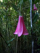
Chilean wax bell
(Lapageria rosea)
· 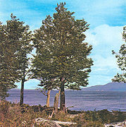
Lenga Southern Beech
· 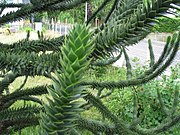
Chilean araucaria
· 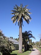
Honey palm (Jubaea chilensis)
In central and southern Chile there are large forests classified as temperate rainforest. They are divided into the Valdivian rainforest in the north and the Magellanic rainforest in the south, both of which were originally dominated by false beech. In the Valdivian Rainforest, some conifers from the southern hemisphere such as Chilean araucaria and Patagonian cypress are added. Today, introduced pines, larches and poplars are also found in Chilean forests.
In the XI region (Aisén) there are forests with, for example, the following tree species: Lenga southern beech (Nothofagus pumilio), Coihue southern beech (Nothofagus dombeyi), Luma apiculata, Aextoxicon punctatum (which is called Olivillo in Chile, among others), Embothrium coccineum, Chilean false elm (Eucryphia cordifolia), candle tree (Maytenus boaria).
The "national flower" of Chile is the red Chilean wax bell (Lapageria rosea), it is called Copihue in Chile and is a climbing plant.
Patagonia consists of vast steppes and semi-deserts, on the southwest coast is the so-called Magellanic tundra. Large parts of the Aisén region and the Magallanes region are already glaciated, so that no vegetation can be found here anymore.
Tierra del Fuego is criss-crossed by large moors. Here, only a few tree species remain, such as the Lenga southern beech, the Magellan southern beech (Nothofagus betuloides) or the Coihue southern beech (Nothofagus dombeyi).
Fauna
In the steppe regions, guanacos, which belong to the camel family, are widespread. In the Andean regions live vicuñas and the huemul, which is the national animal of Chile and is represented on the national coat of arms together with the Andean condor.
The chinchilla, a rodent, and the puma also live in mountainous steppe landscapes. The forests are home to deer, Chilean forest cats, foxes and hummingbirds.
The Humboldt penguin, pelicans and maned seals live even on the cold coasts of northern Chile, maned seals and Magellanic penguins in the ice-rich south.
Spread over almost the entire area of Chile is the majestic Andean condor, one of the largest birds in the world. The large salt lakes are home to thousands of flamingos.
In the barren south of Tierra del Fuego live owls, Magellanic foxes and Darwin's nandus. Very common are shrub rats (degus), small rodents from the family of the opossum rats, which are exclusively native to Chile and similar in appearance to rats and which inhabit almost the entire country with three species. They live in burrows in colonies and occupy the niche in the ecosystem that wild rabbits occupy in Germany.


Questions and answers
Q: What is the official language of Chile?
A: The official language of Chile is Spanish.
Q: What type of climate does the center of Chile have?
A: The center of Chile has a Mediterranean climate with an average temperature of 28°C (82°F) in January and 11°C (52°F) in July.
Q: How much rainfall does the Atacama Desert receive per year?
A: The Atacama Desert receives less than 0.05 mm (0.0020 in) of rainfall per year.
Q: What percentage of people living in Chile are not able to read or write?
A: Approximately 2.7% of people living in Chile are not able to read or write.
Q: What is the currency used in Chile?
A: The currency used in Chile is the Chilean peso.
Q: What percentage of people living in Chile are Roman Catholic?
A: Around 62.8% of people living in Chile are Roman Catholic, while 10% are Protestant, and there are some Jews and Muslims as well.
Related articles
Author
AlegsaOnline.com Chile: geography, people, history and notable features Leandro Alegsa
URL: https://en.alegsaonline.com/art/19683
Sources
- simple.wiktionary.org : simple.wiktionary.org/wiki/Special:Search/Chile
- commons.wikimedia.org : commons.wikimedia.org/wiki/Special:Search/Chile
- en.wikinews.org : en.wikinews.org/wiki/Special:Search/Chile
- en.wikiquote.org : en.wikiquote.org/wiki/Special:Search/Chile
- en.wikisource.org : en.wikisource.org/wiki/Special:Search/Chile
- en.wikibooks.org : en.wikibooks.org/wiki/Special:Search/Chile
- en.wikivoyage.org : en.wikivoyage.org/wiki/Chile
- en.wikiversity.org : en.wikiversity.org/wiki/Special:Search/Chile