Chiapas
![]()
This article is about the Mexican state. For other meanings, see Chiapas (disambiguation).
Chiapas [ˈtʃjapas], officially Free and Sovereign State of Chiapas (Spanish Estado Libre y Soberano de Chiapas), is a state in southeastern Mexico whose name comes from the Chiapa indigenous people who settled in the highlands before colonial times. It borders the state of Tabasco to the north, the states of Veracruz and Oaxaca and the Pacific Ocean to the west, and Guatemala to the south and east. Chiapas has an area of 75,634 km² and is administratively divided into 124 municipios.
The state has about 4.9 million inhabitants, of which about one million are of indigenous descent with fourteen Indian ethnic groups. Most of the indigenous people belong to the Mayan ethnic group. These speak primarily Tzeltal or Tzotzil; about 300,000 speak little or no Spanish. The eastern two-thirds of the state is predominantly inhabited by indigenous people.
The state is characterized by poverty, despite optimal climatic conditions for agriculture, part of the indigenous population is undernourished.
The capital is Tuxtla Gutiérrez, the economically most important city is Tapachula. The best known tourist attractions are San Cristóbal de las Casas, formerly known as Ciudad Real, and the ruined city of Palenque from the Classic Mayan period, which is a World Heritage Site. Chiapas has a great diversity of species and nature.
Geography
Agriculture, mineral resources, climate
Due to the climatic conditions of Chiapas, which encompasses several climatic zones (highlands, tropical rainforest in the lowlands, (rainy season May to October) subtropical transitional areas and mountain cloud forest on the Pacific coast), a great variety of plant species thrive here. The climate in the highlands is mild and not subject to seasonal changes; the German writer B. Traven therefore called his travelogue about Chiapas, published in book form, Land of Spring.
fauna and flora
Although rare, Chiapas is home to numerous exotic mammals such as monkeys, howler monkeys, tapirs, anteaters and umbilical pigs. But also big cats like pumas, ocelots and jaguars can be found.
Among the reptiles of the rainforest are especially numerous species of snakes, crocodiles and iguanas. There are also numerous bird species in the rainforests. The approximately 35 cm large Quetzal, one of the most colorful birds of the tropical rainforest, is mentioned here as a representative.
Naturally occurring and particularly important for economic use and trade are mahogany, teak, rubber, caoutchouc and cocoa.
Crops
- in the highlands: coffee (especially the Maragogype variety), wheat, barley, oats, potatoes, sweet potatoes, maize
- in the lowlands: cocoa, corn, rubber, bananas, pineapple, coconut, cotton, avocado, agave, sisal, tomatoes, beans, cassava, pumpkin, chili peppers, potatoes, sweet potatoes, chayote
- in the transition region: maize, sugar cane, wine, oranges, lemons, almonds, chestnuts, olives, nuts, apples, pears, cherries, peaches, avocado, agave, sisal, tomatoes, beans, potatoes, pumpkin, sweet potatoes, manioc
Mineral Resources
Iron, petroleum, precious stones, gas, gold, coal, copper, lead, tin, gemstones, sulfur, silver
.jpg)
Sharp crocodile in the Cañón del Sumidero
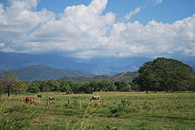
Cattle pasture in the Sierra of Chiapas
Indigenous ethnic groups
Tzeltal
The Tzeltals call themselves "Winik Atel", which simply means "working man". They live mostly from agriculture. They are the largest indigenous ethnic group and settle southeast of San Cristóbal de las Casas. Today there are about 500,000 Tzeltal in Chiapas. Tzeltal Maya is part of the Mayan language family and is spoken by over 470,000 people today - making it the fourth largest language group in Mexico. The Tzeltal language is divided into two dialects. One formed in the highlands, the other in the lowlands. Most of the children of this people now also speak Spanish, while the adults are mostly monolingual. The Tzeltal, locally bound, form a social and cultural unit. The main trade product of the Tseltales, besides agricultural products, is unglazed pottery.
Tzotzil
The Tzotzil live concentrated in the highlands and the border area to Tabasco, but they are distributed almost nationwide. The Tzotzil language is spoken by about 350,000 people and is thus only slightly less widespread than the Tzeltal language. The main places of settlement are Chamula, Zinacantán, Chenalhó and Simojovel. The language is closely related to the Tzeltal language and distantly related to the Yucatec Maya of the Lacandones.
Traditionally, many men wear shorts, a long, light cotton undershirt under a goatskin or cotton poncho. The hat is decorated with ribbons. The colors of the costumes vary from village to village. The Chamulatzotzils, for example, wear dark costumes, while the more friendly Zinacantzotzils wear purple and pink costumes with embroidered flowers. The Tzotzil women wear their hair open or braided and their infants in scarves nestled against their bodies.
Trade is primarily carried out by women and girls, while the men stand aside and observe the hustle and bustle. In addition to agricultural products, high-quality handicraft items are offered. Braided, very colourful, richly ornamented belts and bracelets are to be mentioned, but also splendidly woven blankets and pottery are offered. Other ornamental motifs than those belonging to the Tzotzil costume are sold to tourists. This is of superficial magical symbolism.
Among the Tzotzils, ritualized shamanism is pronounced and is mainly performed by women. A very important part of these rituals is the chicken as a sacrificial animal (see also: Chamula). Among the men the readiness to fight is worth mentioning. The Tzotzil Indians not only supported the EZLN's struggle for freedom, but also participated in it, thereby gaining autonomy.
Lacandon
The Maya, also called Lacandones (Lacandon Hach Winik, "true or real people"), are an indigenous people in the lowlands of Chiapas. They are divided into two sub-ethnic groups, the Northern and Southern Lacandones.
Among the descendants of the ancient Maya, this ethnic group lives the most isolated, settling in the middle of the lowland jungle. The Lacandones have split culturally in the last century - the Lacandones who settle near Bonampak were Christianized by evangelical missionaries. These opened up to tourism and also set up overnight accommodation for travellers. By selling logging rights, some of these Lacandons have become very wealthy. The still traditionally living Lacandones settle near the village of Nahè - near Palenque, there these Mayas still maintain their centuries-old way of life and religion.
Since the 20th century, this small culture has increasingly come into contact with "Western civilization". As a result of this acculturation and the various missionary attempts, the culture of the (estimated) 600-1000 Lacandons is acutely threatened with disappearance. The Lacandons also settle near tourist magnets such as the ruins of Palenque. There, male Lacandons trade or barter homemade goods (arrows, small bows). B. Traven writes that in the early 1930s the Lacandons still lived naked in the jungle, meanwhile the Lacandon men wear white long cotton shirts and the hairstyle is often fringe. Hair length varies, usually the ends of the hair reach the chest area. The Lacandones have not joined the EZLN.
Tojolabal
The Tojolabal settle in the border area with Guatemala. It is assumed that they migrated to Chiapas from present-day Guatemala before colonization. The approximately 35,000 members of the Tojolabal speak their own language and only a few still know Spanish. Only the women wear traditional costumes, the blouses are white, the skirts colorful. All garments are embroidered with richly ornamented ribbon motifs. Unmarried women wear their hair open, married women tied into two braids. All married women wear headscarves, unmarried women and girls only occasionally.
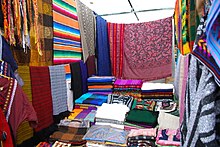
Indigenous weaving at a market in San Cristóbal de las Casas
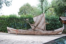
Lacandon canoe in front of a museum in San Cristóbal de las Casas
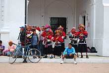
Tzeltal dancers in traditional costume, in San Cristóbal de las Casas
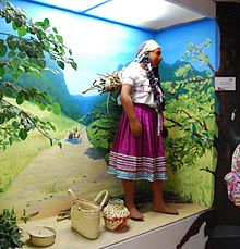
Tojolabal costume in a museum in San Cristóbal de las Casas
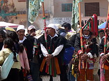
Procession in San Juan Chamula, the cultural center of the Tzotzil people
Questions and Answers
Q: What is the southernmost state of Mexico?
A: The southernmost state of Mexico is Chiapas.
Q: What states border Chiapas?
A: Chiapas is bordered by the states of Tabasco to the north, Veracruz to the northwest, and Oaxaca to the west. To the east it borders Guatemala, and to the south it borders the Pacific Ocean.
Q: How much area does Chiapas have?
A: Chiapas has an area of 28,528 square miles (73,890 km2).
Q: What type of weather does Chiapas generally have?
A: In general, Chiapas has a humid, tropical climate.
Q: What was once found in northern areas near Teapa?
A: In northern areas near Teapa there was once lowland tall perennial rainforest vegetation which has since been destroyed for agriculture and ranching purposes.
Q: Name some cities located in Chiapas.
A: Some cities located in Chiapas include Tuxtla Gutiérrez, San Cristóbal de las Casas, Comitán, and Tapachula.
Q: What social issues are present in Chiapas?
A: Social issues present in Chiapas include a high rate of malnutrition estimated to affect over 40% of its population as well as increasing presence of Central American gangs known as Marras and illegal immigration from Central America which worsens local poverty due to Human Rights violations against migrants.
Search within the encyclopedia