
Chesapeake Bay — geography, ecology, history, and human uses
Chesapeake Bay is the largest estuary in the United States. This article explains its geography, watershed, ecology, economic roles, threats, and restoration efforts.
Overview
The Chesapeake Bay is the United States' largest estuary, a partly enclosed coastal body of water where fresh and salt water mix. The bay's broad inlet lies off the Atlantic Ocean and is bordered primarily by Maryland and Virginia. It receives freshwater from an extensive watershed and supports diverse habitats, fisheries, and communities along its shores.
Image gallery
10 Images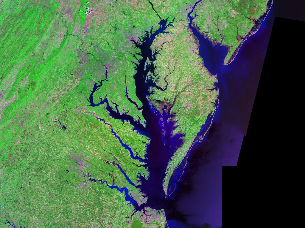


Geography and hydrology
Stretching roughly 200 miles from its northern reaches to the ocean, the bay narrows and widens along its length. The principal tributary is the Susquehanna River, which supplies a large fraction of the bay's freshwater. More than 150 rivers and streams flow into the estuary. At its narrowest the bay is only a few miles across, while at its widest it opens to many tens of miles. Average depth is modest compared with the open ocean, producing extensive shallow flats, marshes, and tidal creeks that influence circulation and biology.
Watershed and political geography
The bay's drainage basin spans parts of several states and the District of Columbia. The watershed includes portions of New York, Pennsylvania, Delaware, Maryland, Virginia, and West Virginia, plus the District of Columbia. Land use across this broad region—agriculture, urban development, and forestland—strongly affects water quality and the bay's ecological condition.
Ecology and natural resources
Chesapeake Bay supports a variety of habitats including tidal marshes, submerged aquatic vegetation, oyster reefs, and sandy shoals. These habitats sustain commercially and culturally important species such as blue crab, oysters, striped bass, and numerous waterfowl. The mix of fresh and saline water creates gradients that allow different biological communities to thrive from the northern fresher waters to the southern more saline reaches.
Human use, history, and culture
For centuries the bay has been central to the economy and culture of the region. Indigenous peoples, colonial settlements, and modern cities all have relied on the bay for food, transportation, and trade. Fisheries, recreational boating, tourism, and ports remain important today. Historic and contemporary connections to seafood, boatbuilding, and waterfront communities are part of the bay's identity.
Environmental issues and restoration
Chesapeake Bay faces long-standing environmental challenges: nutrient and sediment pollution, habitat loss, overfishing, and the effects of development and climate change. Excess nitrogen and phosphorus fuel algal blooms that reduce oxygen levels and harm aquatic life. Efforts to restore the bay involve state and federal agencies, local governments, scientists, and citizens working on nutrient reduction, habitat restoration, and improved land-use practices.
Notable crossings and places
The bay is spanned by major transportation links. In Maryland the Chesapeake Bay Bridge connects the western shore near Annapolis with Kent Island; in Virginia a longer facility, the Cape Charles-area crossing and the Virginia Beach approaches are associated with the Chesapeake Bay Bridge and the Chesapeake Bay Bridge-Tunnel. Local place names and counties such as Plum Point in Kent County and Harford County mark familiar navigation and shoreline reference points.
As an estuary with national significance, the Chesapeake Bay continues to be the focus of science, policy, and community action intended to balance human uses with sustaining its ecological functions for future generations. For further reading on estuary basics and regional programs see resources listed by government and conservation organizations (estuary overview, national context).
Questions and answers
Q: What is the Chesapeake Bay?
A: The Chesapeake Bay is the largest estuary in the United States. It lies off the Atlantic Ocean and is surrounded by Maryland and Virginia.
Q: How big is its watershed?
A: Its watershed covers 64,299 square miles (166,534 km2) in the District of Columbia and parts of six states: New York, Pennsylvania, Delaware, Maryland, Virginia, and West Virginia.
Q: How long is it?
A: The Chesapeake Bay is about 200 miles (300 km) long from the Susquehanna River in the north to the Atlantic Ocean.
Q: What is its width at its narrowest point?
A: At its narrowest point between Kent County's Plum Point (near Newtown) and the Harford County shore near Romney Creek, it is about 2.8 miles (4.5 km) wide.
Q: What is its width at its widest location?
A: At its widest location it is 30 miles (50 km) wide.
Q: How deep on average does it reach?
A: The bay reaches 46 feet (14 m) deep on average.
Q: Are there any bridges over it?
A: Yes, there are two bridges over it - The Chesapeake Bay Bridge crosses the bay in Maryland from Sandy Point (near Annapolis) to Kent Island; while The Chesapeake Bay Bridge-Tunnel in Virginia connects Virginia Beach to Cape Charles.
Related articles
Author
AlegsaOnline.com Chesapeake Bay — geography, ecology, history, and human uses Leandro Alegsa
URL: https://en.alegsaonline.com/art/19319