
Central Mount Stuart: geography, history and significance
Central Mount Stuart is a reddish sandstone hill in the south Northern Territory, Australia, known for John McDouall Stuart's 1860 expedition, a historic cairn and its role in map‑making and travel along the Stuart Highway.
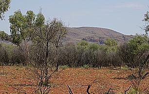
Central Mount Stuart is a conspicuous rocky hill in the southern part of the Northern Territory of Australia. The mound rises as a dark red, sandstone cone that can be seen from some distance and lies a few kilometres east of the major north–south road known as the Stuart Highway. Though modest in height compared with nearby ranges, the mount has long served as a landmark for travellers and surveyors.
Image gallery
4 Images

Location and geology
The feature is located in the arid interior of the Northern Territory, within the broad central Australian landscape of spinifex, stony plains and scattered ranges. The summit is composed primarily of dark red sandstone and related sedimentary rocks, giving it a distinctive colour and a cone‑like profile. The summit and slopes show typical erosion patterns for exposed sandstone in a dry climate: steep faces, talus below cliffs and a weathered cap that contrasts with surrounding plains. The area is accessible from the highway, which passes about 6 km from the hill, making it a visible waypoint for road users traveling the spine of Australia.
Exploration and naming
The mount is best known for its association with the explorer John McDouall Stuart, who reached the locality in April 1860 during one of his transcontinental expeditions. Stuart and his party climbed the hill to survey the country and to record their passage. Early mapmakers and explorers regarded the area as near the geographic centre of the continent; Stuart himself identified a point close to the mount as central. Subsequent cartographic and geodetic work, using different definitions and more precise methods, placed the mathematical centre elsewhere, near the Finke region, so modern references usually treat the ‘‘centre’’ as a conceptual or historical one rather than a precise scientific designation.
Historic objects and later events
During his ascent Stuart left a small bottle containing a paper slip signed by members of the expedition. That note was later recovered during construction of the Overland Telegraph Line in 1871 and preserved; it remains an artifact of nineteenth‑century inland exploration and is held in a South Australian collection. Stuart originally named the peak Central Mount Sturt in honour of his former leader, Charles Sturt. The name was changed soon afterwards to Central Mount Stuart at the suggestion of the Governor of South Australia, Sir Richard MacDonnell, and the altered form was used in the published account of the expedition following Stuart's return to Adelaide.
Legacy, cultural context and access
Central Mount Stuart occupies a place in the story of European exploration of Australia. Journal entries from the expedition capture the language and attitudes of the era; excerpts and place names reflect nineteenth‑century ideals and claims about progress, such as references to liberty, civilization and religion. Those statements are historical documents rather than balanced interpretations of contact and change: the region has a much longer Indigenous history and ongoing cultural significance that predates and outlasts the exploration period.
- Landmark: a visible waypoint beside the Stuart Highway that has guided travellers and surveyors.
- Geology: dark red sandstone, eroded cone with steep faces and rubbly slopes.
- History: climbed and recorded by John McDouall Stuart in April 1860; associated artifacts were recovered during telegraph construction.
- Names: originally named for Charles Sturt, later standardized to Central Mount Stuart.
Visitors today can view the mount from the highway and reach closer vantage points on unsealed tracks; anyone going beyond the roadside should be prepared for remote‑area conditions. For historical context, primary accounts of the 1860 expedition and documentation about the recovered bottle and its paper slip are preserved in Australian archives. For broader reading on the region and expedition narratives see sources linked in this article: mount reference, sandstone description, and archival or interpretive entries that discuss Stuart's words about the local people and ‘‘the dawn of liberty’’ (reference to Indigenous peoples, dawn of liberty, civilization, Christianity).
Central Mount Stuart remains a concise case study of how a natural feature can gain layered meanings: physical landmark, a point in exploration history, a site of colonial commemoration, and a place set within a deep Indigenous landscape. Those overlapping stories make it of interest to travellers, historians and anyone studying the mapping and settlement of inland Australia.
Questions and answers
Q: What is Central Mount Stuart?
A: Central Mount Stuart is a mountain in the south of the Northern Territory, Australia.
Q: How far away is it from the nearby Stuart Highway?
A: Central Mount Stuart is about 6 km away from the nearby Stuart Highway.
Q: What material is it made out of?
A: The mountain is made from dark red sandstone.
Q: Who named the mountain after and why?
A: The mountain was named after explorer John McDouall Stuart who reached the area on 22 April 1860. He worked out that a point about 4 km (2.5 miles) south-southwest of the mountain was the centre of Australia.
Q: What did John McDouall Stuart do when he reached to top of the mountian?
A: When he reached to top of the mountian, he placed a small bottle with a slip of paper inside containing his signature and those of his companions, stating that they had raised it there, and then gave three cheers for civil and religious liberty.
Q: Who found this slip paper in 1871?
A: The slip paper was found by John Ross during building work on Australian Overland Telegraph Line in 1871.
Q: What name did Charles Sturt originally give to this mountain?
A: Charles Sturt originally called this mountain Central Mount Sturt but it was changed to Central Mount Stuart by suggestion from Governor Richard MacDonnell soon after John McDouall's return to Adelaide at end of expedition.
Related articles
Author
AlegsaOnline.com Central Mount Stuart: geography, history and significance Leandro Alegsa
URL: https://en.alegsaonline.com/art/18057
Sources
- gutenberg.org : "Explorations of Australia"
- samemory.sa.gov.au : "Taking it to the edge: did you know? Central Mt Stuart and the geographical centre of Australia"
- ntlis.nt.gov.au : Northern Territory Place Names Register