Celtic Sea
The Celtic Sea is the part of the Atlantic Ocean lying off southern Ireland and the adjacent coasts of Great Britain and Brittany. It is a shallow shelf sea with important fisheries, shipping routes and marine habitats.
Overview
The Celtic Sea is a marine region of the northeastern Atlantic located off the south coast of Ireland. Its name reflects the cultural and historical links of the coasts that border it. In different regional languages it is known as An Mhuir Cheilteach (Irish), Y Môr Celtaidd (Welsh), An Mor Keltek (Cornish) and La Mer Celtique (French). Geographically it is part of the greater Atlantic Ocean and lies immediately south of Ireland.
Image gallery
3 Images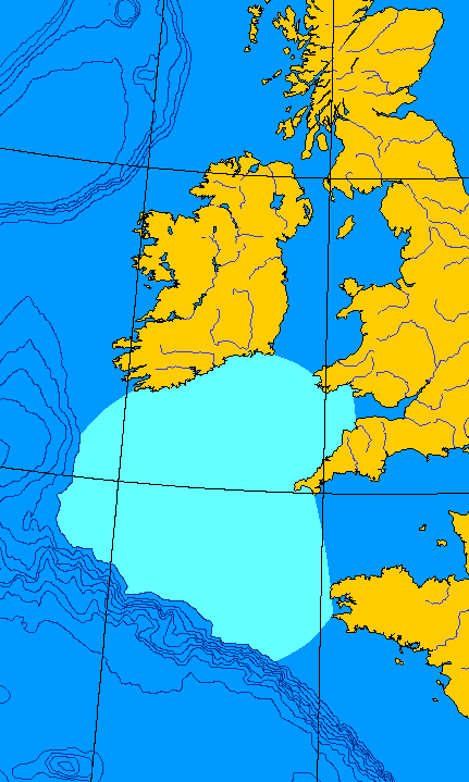


Geography and boundaries
The eastern approach to the Celtic Sea connects with a series of channels and basins. To the east and southeast it borders the Bristol Channel and the English Channel, and further south with the Bay of Biscay. Along its shores are portions of Wales, Cornwall, Devon and the French region of Brittany. The sea’s southern and western edges are commonly defined by the limit of the continental shelf and the transition to deeper Atlantic waters (continental shelf).
Physical characteristics
The Celtic Sea is largely a continental-shelf area, so it is shallower and more gently sloping than the adjacent deep-ocean basins. Sediments on the seafloor include sands, gravels and muds, and the seabed features banks and bedforms shaped by tides and currents. Water temperatures, salinity and circulation patterns are governed by Atlantic inflows, seasonal heating, and exchanges through the connecting channels.
Ecology, resources and uses
As a shelf sea, the Celtic Sea supports productive marine ecosystems. It is important for commercial fisheries, including groundfish and scallop beds, and provides feeding and migration routes for seabirds and marine mammals. The area is also used for shipping, recreational boating and has been considered for offshore energy developments such as wind farms and hydrocarbon exploration. Marine conservation efforts and fisheries management aim to balance use with the protection of habitats and species.
History, naming and notable facts
The term Celtic Sea highlights cultural links across neighbouring coasts and is widely used in charts, research and regional planning. Its boundaries are described in nautical and scientific sources rather than as a sovereign maritime region. The Celtic Sea plays a practical role in regional economies, ecology and navigation and is often referenced in studies of shelf-sea processes in the northeast Atlantic.
- Local names and language forms: Irish, Welsh, Cornish, French
- Adjacent marine regions and channels: Bristol Channel, English Channel, Bay of Biscay
- Bordering lands: Ireland, Wales, Cornwall, Devon, Brittany
- Geological boundary marker: continental shelf
- General ocean: Atlantic Ocean

Related articles
Author
AlegsaOnline.com Celtic Sea Leandro Alegsa
URL: https://en.alegsaonline.com/art/17931