Cascade Volcanic Arc
A chain of volcanic centers in the Pacific Northwest stretching from British Columbia to northern California, formed by subduction and including many prominent stratovolcanoes and shield volcanoes.
Overview
The Cascade Volcanic Arc, commonly called the Cascades, is a north–south chain of volcanic centers that extends through southwestern British Columbia, Washington, Oregon and northern California. It lies along the crest of the larger Cascade Range within the broader Pacific Northwest and includes a mix of large stratovolcanoes, shield volcanoes and numerous smaller vents.
Image gallery
10 Images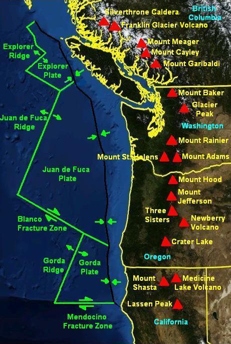


Characteristics and major features
The arc contains about 20 major volcanic edifices and more than 4,000 known vents of varying size and age. About a dozen of the Cascade peaks rise above 10,000 feet (≈3,000 m); the tallest, Mount Rainier and Mount Shasta, exceed 14,000 feet. By physical volume some of the largest Cascade volcanoes are broad shield volcanoes such as Medicine Lake and Newberry. The group includes classic conical stratovolcanoes, compound volcanoes, lava domes and extensive lava flows.
Geology and development
Cascade volcanism is the surface expression of long‑term subduction beneath the western margin of North America. Magmatism associated with the arc began tens of millions of years ago (commonly cited as around 37 million years), but many of the present cones are geologically young—the majority formed within the last two million years. Eruptive styles range from effusive basaltic flows to explosive, gas‑rich eruptions that can produce ash plumes and pyroclastic flows.
Major volcanoes
The arc contains a number of individually well known volcanoes; the following list highlights many of the principal centers, several of which are monitored closely because of their proximity to populated areas:
- Mount Silverthrone
- Mount Meager
- Mount Cayley
- Mount Garibaldi
- Mount Baker
- Glacier Peak
- Mount Rainier
- Mount St. Helens
- Mount Adams
- Mount Hood
- Mount Jefferson
- Three Sisters
- Broken Top
- Mount Bachelor
- Newberry Volcano
- Mount Thielsen
- Mount Mazama (Crater Lake)
- Mount McLoughlin
- Medicine Lake Volcano
- Mount Shasta
- Mount Tehama
- Lassen Peak
History, recent activity and hazards
Although individual vents and cones vary in age, the arc has produced significant eruptions in the recent geologic past. The most widely known modern catastrophic event was the 1980 eruption of Mount St. Helens, which demonstrated the hazards posed by explosive eruptions—ashfall, pyroclastic flows, landslides and lahars. Active and potentially active Cascade volcanoes are routinely monitored for seismicity, ground deformation and gas emissions because even moderate eruptions can disrupt air travel, damage infrastructure, and threaten river valleys and communities.
Importance and distinction
The Cascades are important for their ecological, economic and recreational roles: they host national parks, supply water from snow and glaciers, and attract tourism for climbing and skiing. Geologically, the arc contrasts with other volcanic provinces by combining tall, glaciated stratovolcanoes with broad shield complexes, making it an instructive region for studying subduction‑related magmatism and volcanic hazards.
For further reading on specific volcanoes and monitoring efforts, see dedicated resources and regional geological surveys linked to the individual centers above.
Geology
Cascade volcanoes include nearly 20 large volcanoes among more than 4,000 volcanic vents; there are numerous stratovolcanoes, shield volcanoes, lava domes, and cinder and ash cones, along with a few isolated examples of rarer volcanic forms such as tabular volcanoes. Volcanism in the arc began about 37 million years ago; however, most of the present Cascade volcanoes are less than 2 million years old. Twelve volcanoes reach more than 10,000 ft (about 3,000 m) in height, and the two tallest-Mount Rainier and Mount Shasta-reach more than 14,000 ft (about 4,300 m). In volume, the two largest cascading volcanoes are Medicine Lake Volcano and Newberry Volcano, with their broad shields encompassing 600 km³ and 450 km³, respectively. Glacier Peak is the only Cascade Volcano composed entirely of dacite.
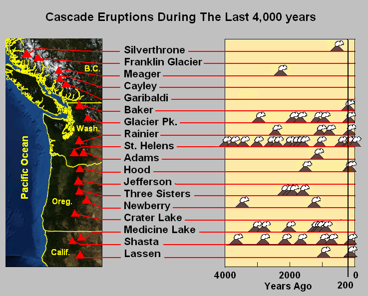
Over the past 37 million years, the Cascade arc has produced a chain of volcanoes throughout the Pacific Northwest. Several Cascade volcanoes are active on a regular basis. Cascade volcanoes share some characteristics, but each has its own unique geologic features and history. Lassen Peak in California, which last erupted in 1917, is the southernmost volcano active in historical time in the arc, while Mount Meager in British Columbia, which erupted about 2,350 years ago, is generally considered the northernmost in the chain. A few isolated volcanic centers northwest of the Mount Meager massif, such as the Silverthrone Caldera, which is a circular caldera complex about 32 kilometers in diameter, may equally be the product of Cascadia subduction because the igneous rocks andesite, basaltic tandesite, dacite, and rhyolite may be found there as well as anywhere else in the subduction zone. There is disagreement on estimates of plate configuration and subduction rate, but based on the chemical data for these volcanoes, they are related to subduction and therefore part of the Cascade Volcanic Arc. The Cascade Volcanic Arc appears to be segmented, as the central part is the most active, while the northern part is the least active.
Lava represents the earliest stage in the evolution of the Cascade volcanic arc, which is predominantly exposed south of the North Cascades proper, where uplift of the Cascade chain was less and a thicker blanket of volcanic rocks has been preserved. In the North Cascades, geologists have yet to confidently identify any 35-million-year-old volcanic rocks, but remnants of the internal tube system of the prehistoric arc persist in the form of plutons, which are crystallized magma chambers that once fed the Cascades volcanoes. The largest mass of these pipes in the Cascade arc is the Chilliwack batholith, which makes up much of the northern area in North Cascades National Park and adjacent areas in British Columbia. Individual plutons are between 35 million and 2.5 million years old. The older rocks that were covered by the magma have been altered by the heat.
Around the plutons of the batholith, the older rocks recrystallized. This contact metamorphism produced a fine network of interwoven crystals in the older rocks, generally hardening them and making them more resistant to erosion. Where recrystallization was intense, the rocks took on a new, dense, dark, and hard appearance. Many jagged peaks in the North Cascades owe their prominence to these processes. These rocks form some of the giants of the North Cascades such as Mount Shuksan, Mount Redoubt, Mount Challenger, and Hozomeen Mountain, all of which were formed in part by plutons from the nearby or underlying Chilliwack batholith.
The Garibaldi Volcanic Belt is the northern extension of the Cascade Volcanic Arc. Volcanoes in this vast volcanic field are mostly stratovolcanoes like the rest of the Cascade arc, but can also be calderas, cinder and ash cones, and small isolated lava masses. Eruption types in the Belt range from effusive to explosive with compositions ranging from basalt to rhyolite. Because of repeated continental and alpine glaciations, many volcanic deposits reflect complex interactions between magma composition, topography, and variable ice configurations. Four volcanoes in the Belt have emerged since 1975 in association with seismic activity, including the Mount Meager massif, Mount Garibaldi, and the Mount Cayley massif.
The Pemberton Volcanic Belt is an eroded volcanic field north of the Garibaldi Volcanic Belt, which appears to have been formed in the Miocene before it broke off from the north end of the Juan de Fuca Plate. The Silverthrone Caldera is the only volcano in the Belt to have emerged during seismic activity since 1975.
The Mount Meager massif is the least stable volcanic massif in Canada. It has dumped layers of clay and rock several metres thick in the Pemberton Valley at least three times during the last 7,300 years. Recent drilling in the floor of the Pemberton Valley encountered residue from a landslide that dates to just before the last eruption of the volcano 50 km away 2,350 years ago. About 1 billion m³ of rocks and sand were spread across the valley. Two previous landslides about 4,450 and 7,300 years ago, brought debris over at least 32 km from the volcano. Recently, the volcano has caused minor landslides about every decade including one that killed four geologists near Meager Creek in 1975. The likelihood of the Mount Meager massif topping stable sections of the Pemberton Valley with a landslide is estimated to be within 2,400 years. There is no evidence of volcanic activity coupled with these events. However, scientists warn that the volcano could cause a massive landslide in populated areas without warning.
In the past, Mount Rainier caused the largest debris avalanches and also produced powerful lahars due to the presence of large amounts of glacial ice. Its lahars have traveled all the way to Puget Sound. About 5,000 years ago, a large piece of the volcano slid; the debris avalanche contributed to the massive Osceola Mudflow, which reached as far south as present-day Tacoma and into southern Seattle. This massive avalanche of ice and rocks carried away the top 1,600 ft (about 490 m) of the mountain, reducing its height to about 14,100 ft (about 4,300 m). About 530 ... 550 years ago, the Electron Mudflow occurred, but it was not as violent as the Osceola Mudflow.


Cascadia Subduction Zone
→ Main article: Cascadia subduction zone
The Cascade Volcanoes were formed by the subduction of the Juan de Fuca Plate, the Explorer Plate, and the Gorda Plate (remnants of the much larger Farallon Plate) beneath the North American Plate along the Cascadia Subduction Zone. This is a 680 mi (about 1,090 km) long fault that runs about 50 mi (80 km) beyond the coast of the Pacific Northwest from northern California to Vancouver Island in British Columbia. The plates move at a rate of more than 10 millimeters per year at a somewhat oblique angle.
Because of the large area occupied by the fault, the Cascadia subduction zone can produce violent earthquakes (magnitude 9.0 or greater) when stresses are discharged over the entire area. If the "closed" zones store energy for an earthquake, the "transition" zone can rupture despite some plasticity. Thermal and deformation studies suggest that the closed zone is completely blocked and can dip about 60 km below the deformation boundary. Further dipping produces a transition from completely blocked to aseismic slip.
Unlike most subduction zones worldwide, there is no deep-sea channel along the continental margin in the Cascadia subduction zone. Instead, terranes and accretionary wedges were uplifted, creating a series of coastal mountains and exotic mountains. A high rate of sedimentation from the three main drainages (Fraser River, Columbia River, and Klamath River) that cross the Cascadia Range contribute to the further obscuring of the continental margin. However, consistent with most subduction zones, the outer continental margin is compressed, much like a giant spring. If the stored energy is suddenly released by a slip across the fault, the Cascadia subduction zone can produce very strong earthquakes like the one of 1700, which had a magnitude Mw of 8.7-9.2.

Questions and answers
Q: What is the Cascade Volcanic Arc?
A: The Cascade Volcanic Arc is a major range of volcanoes in southwestern British Columbia, Washington, Oregon, and northern California. It is part of the Cascade Range, a mountain range in the Pacific Northwest.
Q: How many volcanoes are included in the arc?
A: The arc includes about 20 major volcanoes and over 4,000 separate volcanic vents.
Q: How tall are some of the tallest volcanoes in the arc?
A: Twelve volcanoes in the arc are over 10,000 ft (3,000 m) in height and two of them - Mount Rainier and Mount Shasta - are even taller at 14,000 ft (4,300 m).
Q: When did volcanic activity begin in this region?
A: The volcanism in this region began about 37 million years ago.
Q: What was the most recent catastrophic eruption to occur here?
A: The most recent major catastrophic eruption was at Mount St. Helens on May 18th 1980.
Q: What are some examples of notable volcanoes located within this area?
A: Notable volcanoes located within this area include Mount Silverthrone, Mount Meager, Mount Cayley, Mount Garibaldi, Mount Baker Glacier Peak ,Mount Rainier ,Mount St. Helens ,Mount Adams ,Mount Hood ,Mount Jefferson ,Three Sisters Broken Top ,Mount Bachelor Newberry Volcano ,Mount Thielsen ,Mount Mazama (Crater Lake), Mount McLoughlin Medicine Lake Volcano ,Mount Shasta and Lassen Peak .
Related articles
Author
AlegsaOnline.com Cascade Volcanic Arc Leandro Alegsa
URL: https://en.alegsaonline.com/art/17379