Carpathian Mountains — the great arc of Central and Eastern Europe
A balanced overview of the Carpathian Mountains: geography, geology, ecology, human use, and notable subranges spanning several Central and Eastern European countries.
Overview
The Carpathian Mountains form a long, curving arc of highlands and ranges in Central and Eastern Europe and are often considered the eastern wing of the larger Central European mountain system. They extend for roughly 1,500 km and create a distinct natural region that influences climate, rivers, and patterns of settlement across many states.
Image gallery
10 Images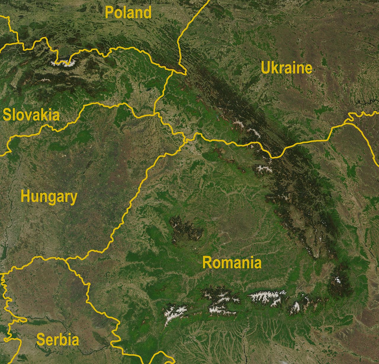


Geography and geology
The chain is made up of multiple parallel ranges, basins and foothills, varying from rugged alpine peaks to forested hills. The highest summits are found in the Tatra Mountains, part of the Western Carpathians. The range developed through complex tectonic processes during the Alpine orogeny and shows a mixture of crystalline cores, sedimentary belts and volcanic structures.
Countries and major sectors
The Carpathians cross or border several countries: Romania, Czech Republic, Slovakia, Poland, Ukraine, Austria, Serbia, and parts of northern Hungary. Geographers commonly divide the system into Western, Eastern and Southern Carpathians, each with its own character and river drainage patterns.
Ecology and human use
Large tracts of the Carpathians remain covered by temperate broadleaf and mixed forests, supporting diverse wildlife including large carnivores and numerous endemic plants. The mountains supply timber, pasture, freshwater and recreational opportunities; they are home to traditional mountain agriculture, pastoralism and small towns that rely on tourism and forestry.
History, protection and notable facts
Historically the Carpathians have acted as cultural and ecological frontier zones, shaping migration routes and local identities. Modern conservation efforts include national parks and transboundary initiatives to protect habitats and restore populations of emblematic species. Major subranges and features include:
- High Tatras (Western Carpathians) — highest peaks and glacial valleys
- Apuseni and Bucegi (Romania) — karst landscapes and plateaus
- Eastern Carpathians — volcanic ranges and broad forests
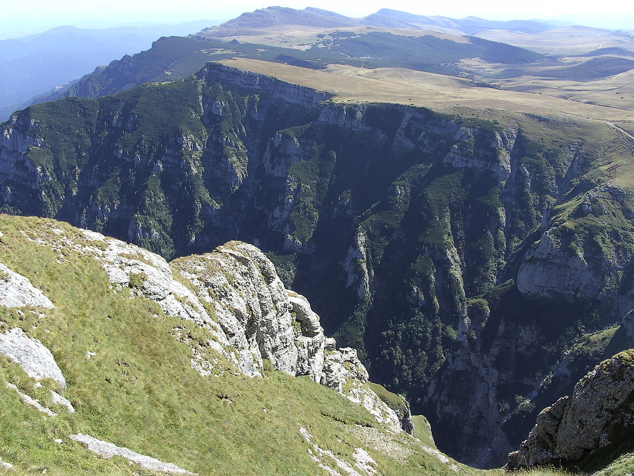
- Southern Carpathians (Transylvanian Alps) — steep ridges and river gorges
For regional context and further reading consult national park pages and regional geological summaries available through specialist sources and conservation organizations.


Name
The form Carpathians is mentioned in Greek (ó Karpátes oros [so in Ptolemy, 2nd century AD], tó Karpafon oros), Roman (Carpates montes, Carpatae) and Middle Latin texts (Carpati montes, Alpes Bastarnicae [Tabula Peutingeriana]). It corresponds to the name given to the Carpathian people in the 2nd century AD, who settled east of the Romanian Eastern Carpathians. In Roman times, the Carpathians were also called Montes Sarmatici after the Sarmatians. In documents of the Kingdom of Hungary from the 13th and 14th centuries, the mountains were referred to as Thorchal, Tarczal or Montes Nivium.
The origin of the name Carpathians is unclear. Suggestions include the Indo-European *kar- 'praise' or Albanian karpe (rock) from Indo-European (s)ker- (to cut; cf. German Kerbe and Kar as well as Latin carpere (to pluck)). Another possible origin seems to be the Slavic word chrebet (backbone, ridge).
Geography
General
The Carpathian arc encloses the Hungarian Plain from the north and east and separates it from north-central and eastern Europe. The Carpathians are mainly formed by Poland, Slovakia, Ukraine and Romania, and to a lesser extent, or via the foothills, by Austria, the Czech Republic, Hungary and Serbia.
The mountain arc of the Carpathians is more curved than the Alpine arc. Geologically, both mountain arcs are a result of the plate tectonic processes of the past 100 million years. The northward pressure of the African plate against the European part of the Eurasian plate has caused the folded mountains in the southern half of Europe to arch upwards, especially in the last 30 million years (cf. Alpidic orogeny). The curvature is particularly strong between the Eastern and Southern Carpathians, which together with the Apuseni Mountains enclose almost all of Transylvania and continue beyond the Danube (Iron Gate) in the Bulgarian Balkan Mountains.
The Carpathian Arc is part of the main European watershed in sections and covers an area of about 220,000 km². It has an average width of 150 km and is more than 1300 km long along its curvature. It is composed of a similar variety of rocks as the Alps. The once existing connection between the Eastern Alps and the Western Carpathians sank several kilometres into the depths during the formation of the Vienna Basin, similar to parts of the Pannonian Basin.
The Carpathians have a high diversity of landscapes. Morphologically, they include several high mountain regions with altitudes of more than 2000 m (High and Low Tatras, Eastern and Southern Carpathians), as well as numerous areas with low mountain character (Small and White Carpathians, Slovak Ore Mountains, Western and Eastern Beskids, Transylvanian Basin). The Western Carpathians have some large longitudinal valleys as well as transverse and through valleys (see e.g. Váh, Hron). The highest peaks are in the north (High Tatras, Gerlach Peak, 2655 m) and in the southeast (Moldoveanu, 2544 m).
Structure
→ Main article: Outline of the Carpathians
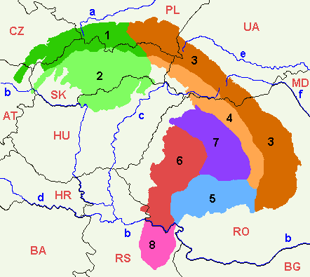
The Carpathians are divided into different parts. Two principles are common here: horizontal on the one hand, and vertical on the other.
Horizontal structure
This results from the age, rock type and surface type.
- The Outer Carpathians stretch from northeastern Lower Austria through Bratislava and the border area between the Czech Republic and Slovakia, then across the border area between Slovakia and Poland (north of the Malá Fatra, Tatra and Vihorlatské vrchy mountains), finally over large parts of the Forest Carpathians and over parts of Romania to an area north of Bucharest. The highest mountain is Babia Góra (Devil's Peak) (1725 m).
- The Inner Carpathians correspond to the rest of the Carpathians. Simplifying, we can say that the Inner Carpathians include the highest parts of the Carpathians (Tatras, Low Tatras, Slovak Ore Mountains, Northern Hungarian Middle Mountains, Rodna Mountains, Retezat Mountains, Parâng Mountains, Harghita Mountains and so on). The Inner Carpathians are divided into the Central Slovakian Block in the north, the Eastern Carpathian Block and Southern Carpathian Block in the southeast, the Apuseni Mountains, and the Volcanic Mountains. The volcanic mountains (Vihorlat, Bükk, Munții Calimani, Gurghiu Mountains, Harghita Mountains, etc.), which form the innermost and youngest part of the Carpathian arc, are often separated out as a separate group (the "innermost" Carpathians).
Vertical structure
This is based on geological-tectonic, physiographic and gross morphographic criteria:
- Western Carpathians: These largely correspond to the territory of Slovakia and the adjacent areas of Austria (northeasternmost Austria from the Vienna Basin), the Czech Republic (eastern Moravia), Poland (southern Poland, part of Lesser Poland), and Hungary (northern Hungary). The border with the Forest Carpathians (Eastern Carpathians in the broader sense) runs in the northeast of Slovakia roughly along the line Bardejov-Michalovce. The highest part of the Western Carpathians and at the same time of the whole Carpathians is the Tatras (Gerlsdorf Peak with 2655 m). The (Outer) Western Carpathians also include a series of mountains traditionally called Beskids. However, the Lower Beskids (sk: Nízke Beskydy, pl: Beskid Niski) in eastern Slovakia and Poland already belong to the (Outer) Eastern Carpathians.
- Southeast Carpathians (also: East Carpathians in the broadest sense):
- Eastern Carpathians in the broader sense: These consist geomorphologically of the Eastern Beskids (group of Lower Beskids, Bieszczady, Bukovské vrchy, the Ukrainian Galicia), the Ukrainian Carpathians (sk: Ukrajinské Karpaty, ua: Ukrajins'ki Karpaty) and the Eastern Carpathians in the narrower sense. The names of the individual main parts of the Eastern Carpathians are quite controversial. The Eastern Beskids and the Ukrainian Carpathians are rather freely referred to in the German-speaking world as the Forest Carpathians (sk: Poloniny, ua: Lisysti Karpaty). Sometimes, however, the Forest Carpathians are also equated with the Ukrainian Carpathians or with the Eastern Beskids, whereby in the case of the Eastern Beskids the additional problem arises that these are themselves not precisely delimited (see under Beskids). In the past, but often still today, even the entire Eastern Carpathians are referred to in a broader sense as the Forest Carpathians. If one follows - as is common in today's geography - the first subdivision mentioned above, the following classification of the Eastern Carpathians in the broader sense results:
- Forest Carpathians: The Forest Carpathians are located in eastern Slovakia (see above), Poland, Ukraine, and a small part of Romania. They end at the Prisloppass in Romania. Their highest elevation is the Howerla (2060 m) in Ukraine, also the highest mountain of the country.
- Eastern Carpathians in the narrower sense: These lie entirely on the territory of Romania, between the Prislop Pass and the Predeal Pass. With the Pietros they reach 2305 m. Many mountain ranges are volcanic (see above under Inner Carpathians).
- Southern Carpathians (also: Transylvanian Alps, Transylvanian Alps): They follow westward from the Predeal Pass. They are in Romania and to a smaller extent in Serbia. They reach an altitude of 2544 meters with the Moldoveanu. The most important mountains are the Fogarasch Mountains and the Retezat Mountains, which are particularly rich in mountain lakes. The Banat Mountains are the last mountain range in the west. Romania calls the Banat Mountains and the Apuseni Mountains the Western Carpathians (Carpații Occidentali).
Most important Carpathian rivers with the respective countries of their source
In the Czech Republic:
- March
Poland:
- Wisła (Vistula)
- San (Saan, Sayn)
- Wisłok (White Log)
- Osława (Oslawa)
- Wisłoka (Wittewater)
- Dunajec (Dunajez)
Slovakia:
- Váh (Waag)
- Dunajec (Dunajez)
- Hron (Gran)
- Ipeľ (Eipel)
- Nitra (Neutra)
- Orava (Arwa)
- Poprad (Popper)
- Turiec (Waag)
Ukraine:
- Dnister (Дністер, Romanian Nistru)
- Pruth (Прут, ro: Prut)
- Sereth (Сере, ro: Siret).
- Tisza (Тиса Tyssa, ro/sk/sr: Tisa, Hungarian Tisza)
- Stryj (Стрий).
- Sbrutsch (Збруч)
- Usch (Уж, sk: Uh)
In Hungary
- Ipeľ (hu: Ipoly)
In Romania
- Argeș
- Bârsa (Burzen)
- Bega (Serb. Begej)
- Buzău
- Bistrița
- Cibin (Zibin)
- Dâmbovița
- Jiu
- Târnava (Kokel)
- Screech (ro: Criș, hu: Körös)
- Mara
- Mieresch
- Moldova
- Alt (ro: Olt)
- Someș (Somesh; hu: Szamos)
- Timis (ro: Timiș, sr: Tamiš)
In Serbia
- Mlava
- Pek
- Porečka
- Timok
Larger cities
- Banská Bystrica, Slovakia
- Bielsko-Biała (Bielitz-Biala), Poland
- Bor, Serbia; located south of the Danube, in the Serbian Ore Mountains
- Brașov (Brasov), Romania
- Bratislava, Slovakia
- Drobeta Turnu Severin, Romania
- Košice, Slovakia
- Miskolc, Hungary
- Mukachevo (Munkacs), Ukraine
- Nowy Sącz (New Sandez), Poland
- Ostrava, Czech Republic
- Petroșani, Romania
- Piatra Neamț, Romania
- Ploiești, Romania; located at the southern foot of the mountains.
- Poprad, Slovakia
- Prešov, Slovakia
- Reșița, Romania
- Sanok, Poland
- Sibiu (Hermannstadt), Romania
- Sighetu Marmației, Romania
- Suceava, Romania
- Chernivtsi (Chernivtsi), Ukraine
- Uzhhorod, Ukraine
- Vršac, Serbia
- Zakopane, Poland
- Žilina, Slovakia
- Zlín, Czech Republic

Related articles
Author
AlegsaOnline.com Carpathian Mountains — the great arc of Central and Eastern Europe Leandro Alegsa
URL: https://en.alegsaonline.com/art/17222