Canberra: Australia’s planned national capital
Comprehensive overview of Canberra: its design, history, climate, government institutions and cultural attractions, and the origins of its name and urban layout.
Canberra is the purpose-built national capital of Australia and the administrative centre of the country. The city sits within the Australian Capital Territory (ACT) and functions as the seat of the federal government (capital of Australia). Home to roughly four hundred thousand residents, Canberra combines formal government precincts, cultural institutions and large areas of planned parkland. Its role as capital, careful urban design and dispersed population distinguish it from Australia's larger state capitals.
Image gallery
10 Images


Planned design and urban form
Canberra is widely known as a planned or "garden" city conceived in the early 20th century. The central feature is Lake Burley-Griffin, a deliberately sited artificial lake that helps define axes and vistas across the city. The original design emerged from an international competition won by the American architect Walter Burley Griffin, who had worked in and around Chicago. Griffin proposed geometric arrangements and broad avenues: a plan with triangular sectors and radial links that deliberately integrated open space and built form (triangular layout). That intention—low-density development set among substantial public parks—gives Canberra a very different appearance from compact European capitals; its municipal area is often compared in scale to cities such as Berlin, while its population is much smaller.
Origins and early history
The decision to establish a new capital followed prolonged rivalry between Australia's two largest cities, Sydney and Melbourne, over which should host the national government. To resolve that dispute it was agreed the capital would be placed in a separate territory, not part of any state, and in 1908 a location was selected within land ceded by New South Wales. The federal territory chosen occupied several thousand square kilometres at a distance located between the two major cities—intentionally placed away from either rival metropolis on the Australian continent. Formal acts and votes in the first decade of the 1900s (notably in and around 1908) established the legal basis for the capital and the subsequent planning competition.
Climate and natural environment
Canberra experiences a temperate, oceanic-style climate in many classifications, often described as oceanic (Cfb in the Köppen classification) due to mild, wet seasons and relatively cool winters. Its inland setting and elevation influence local weather: the city's modest altitude (altitude) brings warm to hot summers with occasional heat waves and dry spells, and cooler winters with frequent frosts at night. Seasonal droughts (droughts) can affect urban water supplies and surrounding bushland, while snowfall (snow) is uncommon across the lower city but regular at higher elevations in nearby ranges.
Government institutions, culture and visitor attractions
As the national capital, Canberra hosts many of Australia's key federal buildings and national cultural institutions. Its collection of monuments, museums and galleries attracts both domestic and international visitors to the capital precincts (national monuments).
- Parliament House and the parliamentary triangle, where national legislation is debated and enacted.
- The High Court of Australia, the apex of the federal judiciary.
- The Australian War Memorial, combining museum, shrine and research facility.
- The National Gallery of Australia, housing major collections of Australian and international art.
- The National Library of Australia, custodian of national documentary heritage.
- The National Museum of Australia, focused on social history and national identity.
Other civic features include Government House, the Royal Australian Mint, broadcast towers and a variety of cultural festivals and exhibitions. Together these institutions underpin Canberra's role as the symbolic and functional heart of the federal state.
Name, pronunciation and local identity
The name "Canberra" has been subject to differing pronunciations and interpretations over time. Early European settlers recorded various forms such as "Canberry" on local pastoral properties, and Aboriginal placenames from groups of the region—such as the Ngambri/Kamberra people—are cited in discussions of the word's origin. Some sources suggest meanings related to a meeting place or assembly, while other explanations link the name to early homestead titles. Contemporary pronunciation varies across the population, reflecting both historical shifts and regional accents.
Canberra's character rests on its dual role: a working national capital where government and diplomacy occur, and a planned urban landscape emphasising open space, civic monuments and cultural facilities. For further reading on Canberra's institutions and planning, consult official resources and heritage guides that document its development and ongoing role in Australian public life.
Geography
Canberra covers an area of 814.2 km² and is located just east of the Brindabella Range, part of the Snowy Mountains, about 150 km from Australia's east coast. The urban area, which is about a quarter of the area of the Australian Capital Territory (ACT), is located in the north-eastern part of the ACT at an average elevation of 580 metres above sea level. The highest point is the top of Mount Majura hill at 888 metres. Other significant hills include Mount Taylor (856 m), Mount Ainslie (843 m), Black Mountain (812 m) and Mount Stromlo (770 m).
The Molonglo River divides the city into two roughly equal halves. This river is impounded by Scrivener Dam to form Lake Burley Griffin, a large body of water in the city center that reaches 11 km in length and up to 1.2 km in width. Until the lake was dammed, the Molonglo River caused occasional devastating floods. It empties into the Murrumbidgee River, a tributary of the Murray River, northwest of Canberra. Several smaller rivers in the city area or not far from it empty into the Molonglo or the Murrumbidgee. These include the Queanbeyan River, the Cotter River, Jerrabomberra Creek and Yarralumla Creek. Ginninderra Creek and Tuggeranong Creek are dammed to form Lake Ginninderra and Lake Tuggeranong respectively.
The surrounding bushland is now a mixture of savannahs, shrublands, swamps and dry forests, a significant portion of which are combined in the Canberra Nature Park. The native forest in the region, which was once almost entirely eucalypt, served as a fuel and timber resource. Forestry began in 1915 with trials on a range of species including Pinus radiata on the slopes of Mount Stromlo. By the early 1960s, logging had decimated the eucalyptus, and water quality concerns led to the closure of the forests. Since then, plantations have expanded, with the benefit of reducing erosion in the Cotter River watershed. Today, the forests are popular recreational areas.
The population of the ACT lives almost exclusively in Canberra. In the rural part of the ACT there are only a few homesteads and villages with a combined population of just over 5000. The largest settlements are Williamsdale, Naas, Uriarra Village, Tharwa and Hall. Ten kilometres southeast of the city centre, just on the border of the ACT, is the New South Wales state town of Queanbeyan, with a population of around 36,000.
Climate
Canberra has a temperate oceanic climate (effective climate classification: Cfb). Due to the altitude and distance from the coast, there are four distinct seasons, but the climate is drier than in coastal cities. This is due to the city's location in the rain shadow of the Brindabella Range. The climate is characterized by hot to warm, dry summers and (by Australian standards) cool to cold winters with dense fog and frequent frost.
The highest temperature ever recorded was 44.0 °C on 4 January 2020, and three days earlier Canberra measured the worst air quality index of any major city in the world. Both were consequences of the devastating bushfires in Australia in 2019/2020 and the associated heavy smoke development.
The lowest temperature ever measured was -10.0 °C on 11 July 1971. Snow falls on average once or twice a year, but the amount is small and always melts again after a short time. Thunderstorms can occur between October and March, and most rain falls in spring and summer. Generally, the wind does not blow very strongly. The following table shows the average climate values from 1981 to 2010:
| Canberra | ||||||||||||||||||||||||||||||||||||||||||||||||
| Climate diagram | ||||||||||||||||||||||||||||||||||||||||||||||||
| ||||||||||||||||||||||||||||||||||||||||||||||||
| Monthly average temperatures and precipitation for Canberra
Source: Australian Bureau of Meteorology: Canberra Airport Station. Observation period: 1939-2010. Retrieved 27 December 2013. | |||||||||||||||||||||||||||||||||||||||||||||||||||||||||||||||||||||||||||||||||||||||||||||||||||||||||||||||||||||||||||||||||||||||||||||||||||||||||||||||||||||||||||||||||||||||||||||||||||||||||||||||||||||||||||||||||||||||||||||||||||||||||||||||||||||||||||
Geometry of the city center
Canberra is a planned city, with the downtown area originally designed by American architect Walter Burley Griffin (assisted by his wife Marion Mahony Griffin). In the city centre on both sides of Lake Burley Griffin's main streets follow a wheel-and-spoke pattern rather than a grid. Griffin's urban design features an abundance of geometric forms, including concentric hexagonal and octagonal street patterns radiating from multiple radii. The city's later outlying districts, on the other hand, are not geometrically structured.
Lake Burley Griffin has been deliberately designed to relate its orientation to various topographical landmarks in Canberra. A 'land axis' perpendicular to the Central Basin extends from Capital Hill - the site of the new Parliament House - north-northeast across the north shore and along the prestigious ANZAC Parade to the Australian War Memorial at the foot of Mount Ainslie. At the south-western end of the land axis rises Bimberi Peak, the highest mountain in the Australian Capital Territory, about 52 km south-west of Canberra in the Brindabella Range.
The chord of the circular segment that forms the central basin of Lake Burley Griffin is perpendicular to the land axis and is called the "water axis". It extends northwest toward Black Mountain. A line parallel to the water axis on the north side of the city forms the "municipal axis". It corresponds to the course of Constitution Avenue, which connects City Hill in the Civic Centre business district with the Market Centre and the Ministry of Defence on Russell Hill. Commonwealth Avenue and Kings Avenue run from Capital Hill in the south to City Hill and the Market Centre in the north respectively, forming the western and eastern edges of the central basin. The area enclosed by the three streets is called the Parliamentary Triangle; this equilateral triangle forms the heart of Griffin's urban design.
The Griffin couple assigned spiritual values to Mount Ainslie, Black Mountain, and Red Hill, and originally planned to plant each of these hills with flowers. In this way, each hill was to be covered with a single, primary color representing its spiritual value. This part of her plan never came to fruition, as World War I slowed the construction of the capital and planning disputes led to Griffin's dismissal by Prime Minister Billy Hughes at the end of the war.
Urban structure
Canberra's urban areas are hierarchically structured. There are seven wards, each of which is subdivided into smaller neighbourhoods known as 'suburbs', regardless of location. Virtually all of these suburbs in turn have a district centre as a focus of commercial and social activity. The boroughs were settled in this order:
- Canberra Central (comprising North Canberra and South Canberra), largely in the 1920s and 1930s, expansion into the 1960s, 25 neighbourhoods.
- Woden Valley, as of 1964, 12 neighborhoods.
- Belconnen, as of 1966, 27 neighborhoods (two of which are not yet developed).
- Weston Creek, as of 1969, 8 neighborhoods.
- Tuggeranong, as of 1974, 18 districts
- Gungahlin, as of 1993, 18 districts (three of which have not yet been developed)
- Molonglo Valley, from 2010, 13 districts planned
Canberra Central largely follows Griffin's plans. In 1967, the National Capital Development Commission adopted a new superstructure plan, the "Y-Plan". Since then, further urban development has been based on a series of shopping and commercial zones linked by expressways, known as town centres. The layout of these centres resembles the shape of the letter Y. Tuggeranong forms the lower end, while Belconnen and Gungahlin are at the ends of the arms of the Y. Urban development is strictly regulated, partly by town planning measures and partly by restrictive use regulations for parcels of land. The federal government leased all land in the Australian Capital Territory for a period of 99 years, although the Territory government now administers most leases itself. Since the beginning of the 21st century, there have been persistent calls for a relaxation of planning guidelines.
Most neighborhoods have smaller stores and are located near a larger shopping center that serves several neighborhoods. Public facilities and schools are often located near these shops or shopping centres. Many neighbourhoods are named after famous Australians and early settlers or after Aboriginal names. Street names usually follow a particular pattern; for example, streets in Duffy are named after Australian dams, those in Page after biologists and naturalists. Fyshwick, Mitchell and Hume each have a light industry zone. Foreign missions are concentrated in the districts of Yarralumla, Deakin and O'Malley.
enlarge and show information about the picture
![]()
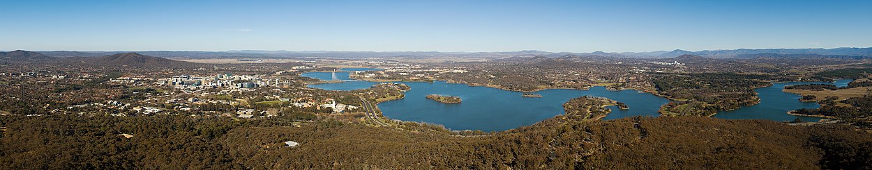
Panorama of Canberra and Lake Burley Griffin, taken from Black Mountain Tower


Population
| Population trends | |
| Year | Inhabitants |
| 1911 | 1777 |
| 1921 | 2583 |
| 1933 | 8947 |
| 1947 | 16.905 |
| 1961 | 58.828 |
| 1966 | 96.013 |
| 1971 | 151.169 |
| 1976 | 207.740 |
| 1981 | 227.581 |
| 1986 | 258.910 |
| 1991 | 289.320 |
| 1996 | 308.251 |
| 2001 | 307.053 |
| 2006 | 322.036 |
| 2011 | 357.222 |
| 2016 | 395.790 |
In 2016, Canberra had a population of 395,790, which equates to a population density of 491 inhabitants/km². The 2016 census found that 1.6% of the population were Aboriginal or Torres Strait Islander and 32.1% were born outside Australia. Most of the foreign-born were from English-speaking countries, led by the United Kingdom at 3.2% and followed by the People's Republic of China (excluding Special Administrative Regions and Taiwan) at 2.9%. India accounted for 2.6% of the population, with another 1.2% born in New Zealand. Since the beginning of the 21st century, the number of immigrants from East and South Asia has increased sharply. Most residents, 72.7%, speak only English at home; the most common foreign languages are Mandarin (3.1%), Vietnamese (1.1%), Cantonese (1.0%), Hindi (0.9%), and Spanish (0.8%).
Compared to other Australian cities, Canberra's population is younger, more mobile and better educated. The average age is 35, with only 12.7% older than 65. Between 1996 and 2001, 61.9% of residents either moved here or left. In May 2017, 43% of 25-64 year olds had an educational qualification equivalent to at least a bachelor's degree, strikingly higher than the national average of 31%.
50% of Canberra residents reported Christianity as their faith in the 2016 Census; the most common denominations are Roman Catholic (22.3%) and Anglican Church of Australia (10.7%). Other religions include Buddhism (2.0%), Islam (1.1%), Hinduism (0.7%), Judaism (0.2%) and 'other' (0.6%). A total of 36.2% of respondents described themselves as non-denominational. The Catholic Archdiocese of Canberra-Goulburn reports directly to the Holy See, while the Anglican Diocese of Canberra & Goulburn is part of the Ecclesiastical Province of New South Wales.
Questions and answers
Q: What is the population of Canberra?
A: There are 403,468 people who live in Canberra.
Q: When was Canberra founded?
A: Canberra was started in 1913.
Q: Who won the competition to design the new capital city of Australia?
A: An architect from Chicago named Walter Burley Griffin won the competition to design the new capital city of Australia.
Q: How big is Canberra compared to Berlin?
A: Canberra has a size in area nearly as big as Berlin, but the number of people who live there is much smaller.
Q: What type of climate does Canberra have?
A: Canberra has an oceanic climate (Cfb in the Köppen climate classification).
Q: What are some famous sights tourists come to visit when they go to Canberra?
A: Some places to visit are the Government House, Parliament House, the High Court of Australia, the Australian War Memorial, the National Gallery of Australia, the Royal Australian Mint, Telstra Tower,the National Library of Australia andthe National Museum of Australia.
Related articles
Author
AlegsaOnline.com Canberra: Australia’s planned national capital Leandro Alegsa
URL: https://en.alegsaonline.com/art/16500
Sources
- abs.gov.au : "3218.0 – Regional Population Growth, Australia, 2015–16:ESTIMATED RESIDENT POPULATION – Australia's capital city populations, June 2016"
- commons.wikimedia.org : Canberra