California Aqueduct
The California Aqueduct, officially known as the Governor Edmund G. Brown California Aqueduct, is an irrigation system and combination of several water supply structures in the U.S. state of California. It is part of the California State Water Project and consists of a combination of canals, tunnels and pipelines, as well as several pumping stations. The purpose is to convey water from the Sierra Nevada mountain area of Northern California to the drier area of Southern California. The California Aqueduct is operated by the Department of Water Resources (DWR). Work on it began in 1963 and the final section Coastal Branch, the end of the pipe is broken up into several distribution sections, was completed in 1997.
The canal system begins at the Sacramento-San Joaquin River Delta and ends after 1129 km in Southern California in the following three terminal branches:
- West Branch: Castaic Lake, !534.5873795381.343107534° 35′ 14.6″ N, 118° 39′ 24.8″ W34.587379-118.656893
- East Branch: Silverwood Lake, !534.3034575382.680092534° 18′ 12.4″ N, 117° 19′ 11.7″ W34.303457-117.319908
- Coastal Branch: Lake Cachuma, !534.58665380.019025534° 35′ 12.0″ N, 119° 58′ 51.5″ W34.586656-119.980975
The California Aqueduct Bikeway was the longest paved bikeway in California in the 1970s at 172 km. It was designed as part of the canal system and ran from Quail Lake to Silverwood Lake in the San Bernardino Mountains. It was closed in 1988 for safety reasons and unresolved liability issues.

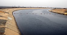
California Aqueduct near the village of Tupman

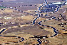
Section of the California Aqueduct with intersection of California Interstate 205.
Search within the encyclopedia