Cairo — Capital and Cultural Centre of Egypt
Cairo is Egypt's capital and largest city, a major political, cultural and economic centre on the Nile with deep historical roots, dense population, and many famous districts and institutions.
Overview
Cairo is the capital of modern Egypt and its largest metropolis. Its Arabic name and script are often given as القاهرة and its common transliteration appears as Al-Qāhirah. As the national capital of Egypt, Cairo functions as the country's main hub for government, higher education, media and major commerce. The city lies on the banks of the Nile, a placement that shaped its growth for millennia.
Image gallery
10 Images


Geography and population
Cairo stretches along both sides of the Nile and has expanded into a wide metropolitan area that includes contiguous suburbs and satellite towns. The city proper is home to several million residents, while the broader urban area contains many millions more, often cited in demographic studies of the region and urban area statistics. Cairo is the largest city in the Arab world and among the most populous urban agglomerations in Africa.
History and development
The modern city dates from the founding of a Fatimid settlement in the tenth century, but the area has been a centre of civilization far earlier, with nearby ancient capitals such as Memphis and long-standing settlements along the river. Over centuries Cairo became a major medieval centre of Islamic scholarship and trade; institutions such as Al‑Azhar and large historic districts reflect that legacy. Successive dynasties, colonial influence and 20th‑century national developments all contributed to the city's urban fabric.
Culture, economy and transport
Cairo hosts national museums, scholarly institutions and a large creative scene that includes film, theatre and publishing. The economy combines public administration, banking, industry and informal sectors. The city is also known for heavy traffic and a packed public transport network that includes buses, trams in some districts, and the Cairo Metro, one of the earliest metro systems in Africa and the Arab world.
Landmarks and districts
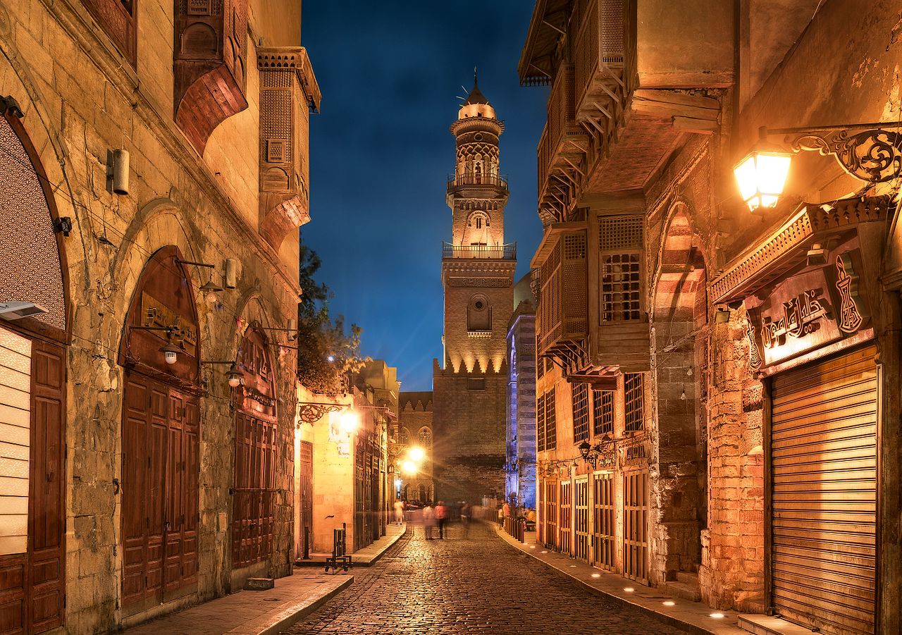
- Historic Islamic Cairo — medieval mosques, markets and lanes.
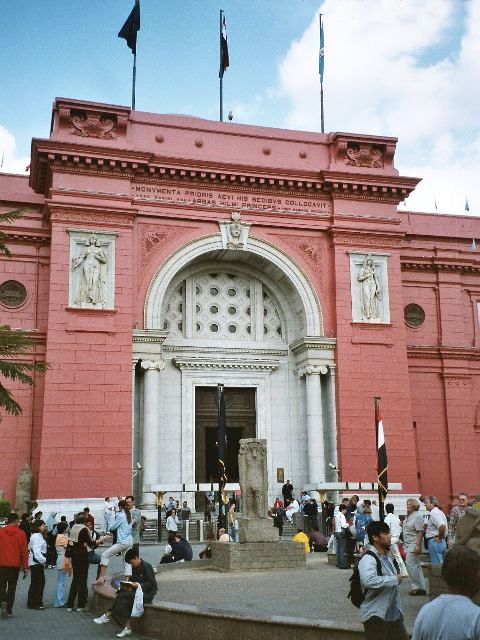
- Tahrir and the Egyptian Museum — central civic and cultural institutions.
- Coptic Cairo — churches and early Christian sites.
- The Citadel and modern government districts — commanding views and administrative centres.
For introductory guides and maps consult general reference sources and tourism pages for perspectives on neighborhoods, visitor sites and current civic projects. See also further summaries and resources: more information.
The city's scale, historical depth and role as a national capital make it a major point of reference for studies of urbanization, Middle Eastern history and contemporary Arab culture.


Geography
Location
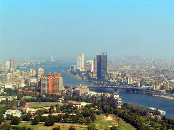
Cairo has a city area of 606 square kilometers and is located in the northeast of the country on the right bank of the Nile on average 68 meters above sea level. The city also includes the two islands of Gezira (الجزيرة, with the district of Zamalek) and Roda (الروضة). Opposite it on the western bank is the governorate of al-Gīza (el-Gīza), including the historic sites of Giza. The geographical coordinates of Cairo are 30° 03' north latitude and 31° 15' east longitude.
The first settlement was originally built between the Muqattam spur to the east and the Nile to the west. But even though these have long since ceased to border Cairo, the quarters that lie between these two natural barriers form the old city core. North of the city, the Nile Delta stretches to the Mediterranean Sea. To the west are the pyramids of Giza. To the south lies ancient Memphis.
Geology
Cairo lies in the valley of the Nile, the world's longest but not most water-rich river, whose headwaters are believed to be the Kagera, which rises in the highlands of Rwanda. The course of the Nile follows a tectonic line. The plateaus located there break here in steps or with uniform steep slopes 100 to 140 meters deep. In the valley the river has formed a series of gravel terraces and deposited an alluvial deposit of black mud averaging ten metres in thickness.
The total width of the valley is two to five kilometers in the south, in the area of the Nubian sandstone, and ten to 15 kilometers in the area of the Tertiary limestones, approximately from Aswan downstream. In places the erosion of the river has reached the recalcitrant rocks of the crystalline basement. West of the present valley remains of an older Nile valley are preserved, for example in the river-fed depression of the Fayyum. Below Cairo, the valley opens up and merges into the wide, canal-lined expanses of the 23,000-square-kilometre delta.
City breakdown
Downtown
The city center can be roughly divided into a traditional and a modern part. Traditional Cairo is located away from the Nile in front of the Citadel and Mount Muqattam (المقطّم). It mainly includes Islamic Cairo around the Azhar and other mosques. Furthermore, the residential neighborhoods to the north, east and south of the neighborhood around the al-Azhar Mosque, such as Bāb el-Chalq (باب الخلق), Darb el-Ahmar (الدرب الأحمر), el-Mūskī (الموسكي) or Sayyida Zeinab (السيّدة زينب es-Sayyeda Zēnab).
enlarge and show information about the picture
![]()
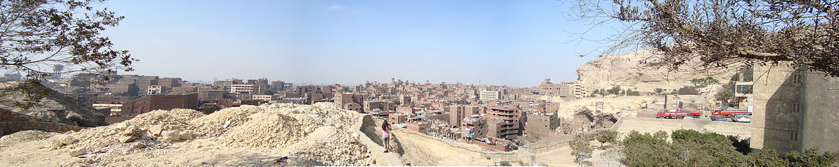
Panorama over Muqattam.
Next to the excavations of al-Fustat in the south is the Coptic Quarter or Old Cairo (مصر القديمة, High Arabic Misru l-qadīma, Egyptian Arabic Masr el-edīma). A special feature is the City of the Dead to the southeast of the Islamic Quarter, a necropolis that is inhabited and now appears (almost) like a normal neighborhood.
Modern Cairo consists of the business districts bordered by the Mīdān et-Tahrīr (ميدان التحرير), the Mīdān el-Ōperā (ميدان الأوبرا), the Ramses Railway Station (محطة رمسيس Mahattat Ramsīs) and the Nile. These areas are still characterized by colonial-era architecture, a Mediterranean architectural style. To the west is the Zamalek neighborhood (الزمالك ez-Zamālek) on Gezīra Island, and to the southwest are Roda Island and Garden City (جاردن سيتي), where many embassies are located.
Suburbs
Probably the best known suburb is Heliopolis (مصر الجديدة, High Arabic Miṣru l-Jadīda, Egyptian Arabic Masr el-Gedīda) in the northeast of the city. To the south is the colonial-era planned Maadi (المعادي al-Maʿādī), characterized by numerous villa estates with surrounding gardens, making it one of the more expensive residential areas. To the south is Helwan (حلوان), which belongs to the governorate of Cairo. Another suburb is Schubra al-Chaima (شبرا الخيمة Schubrā al-Chaima) in the north.
Further out, a distinction must be made between former villages and towns that have been integrated into Cairo's periphery and the satellite towns planned on the drawing board, some of which are directly adjacent to Cairo and some of which are located up to 50 kilometres from the city centre in the desert.
For the latter, on the eastern side of the Nile, Nasr City (مدينة نصر Mādīnat Nasr) and the City of 15. May (مدينة ١٥ مايو Mādīnat Chāmāstashar Māio), and on the western side the City of October 6 (مدينة ٦ أكتوبر Madīnat Sitta Oktobar) and Sadat City (مدينة السادات Madīnat es-Sādāt). The 6th of October City is part of the newly established Governorate of as-Sadis min Uktubar, which also includes the Bahariya Oasis. Sadat City belongs to the governorate of al-Jiza.
New Cairo
→ Main article: New Cairo
The New Cairo urban planning project, which has been underway since 2004, goes far beyond the usual planning of a suburb. It is the answer to the perceived narrowness, housing shortage, noise and partial inhospitability of Cairo's old neighborhoods. Some 17 to 28 kilometers east of the city center, on what was until recently a hilly desert area of about 120 square kilometers, private investors are invited to use the developed building sites.
Accessible by a radial expressway system, ground-level sectors of at least 240 feddan (equivalent to 100 hectares) will be tackled in one pour, their interconnectivity ensured in the master plan grid. This modern relief city is expected to accommodate 2 to 2.4 million people once it is completed after 2020. It is planned to have a social and recreational infrastructure in line with modern requirements, with shopping centres in each area, public green spaces and sports centres run by associations, characterised by an above-average quality of apartments, homes and villas. The first sections were completed at the beginning of 2011: a campus university, several housing estates or partial housing estates and partly private schools of various European countries. The rapid pace of development is striking; the subsections are growing in periods that are unimaginably short by European standards. In terms of rents and purchase prices, New Cairo is likely to become predominantly an urbanisation for the new middle class and for foreign professionals.
On January 6, 2019, the eve of Orthodox Christmas, the newly built Cathedral of the Nativity of Christ was inaugurated in New Cairo. It is the largest cathedral in the Middle East and was financed by the Egyptian state.
Climate
Cairo is located in the subtropical climate zone. The region has a warm and dry desert climate. The average annual temperature is 21.7 degrees Celsius, the average annual rainfall is 24.7 millimeters. The warmest month is July with an average of 28 degrees Celsius, the coldest is January with an average of 13.9 degrees Celsius. Some precipitation falls only between November and March with an average of 3.8 to 5.9 millimeters.
In summer, from May to September, it gets very hot, with the possibility of sandstorms from the south of the country. Temperatures reach daytime highs of up to 35 degrees Celsius with daily sunshine averaging up to 13 hours. At night, temperatures do not fall below 20 degrees Celsius. In the period from October to April, daily highs average 20 to 28 degrees Celsius with a daily sunshine duration of nine to eleven hours. In winter, from December to February, the average daily highs sometimes fall below 20 degrees Celsius and the nightly lows below ten degrees Celsius on average.
In December 2013, Cairo was hit by snowfall for the first time in over a hundred years.
| Cairo | ||||||||||||||||||||||||||||||||||||||||||||||||
| Climate diagram | ||||||||||||||||||||||||||||||||||||||||||||||||
| ||||||||||||||||||||||||||||||||||||||||||||||||
| Monthly average temperatures and precipitation for Cairo
Source: wetterkontor.de | ||||||||||||||||||||||||||||||||||||||||||||||||||||||||||||||||||||||||||||||||||||||||||||||||||||||||||||||||||||||||||||||||||||||||||||||||||||||||||||||||||||||||||||||||||||||||||||||||||||||||||||||||||||||||||||||||||||||||||||||||||||||||||||


History
Previous story
Cairo's origins lie in several settlements. In today's city area was the place Cheri-aha, where according to Egyptian mythology the gods Horus and Seth fought each other. The ancient Egyptian settlement on the east bank of the Nile - the place was called "Babylon in Egypt" - was founded in the 1st century AD under the Romans in the time of Trajan and later developed into a fortress. The name Babylon arose from a misreading of the ancient Egyptian place name "House of the Nile of Heliopolis". Atum and the Nine were worshipped in Babylon. At the end of the 4th century the first Copts began to build churches and protective walls and to settle there.
On April 9, 641, the Arabs conquered the Eastern Roman fortress. Upon their arrival, they found a huge castle complex with 42 churches, large towers, and bastions. In the immediate vicinity of this, ʿAmr ibn al-ʿĀs founded the camp of Fustāt in 643, which gradually developed into a city. The two settlements grew together over time. While little remains of the early Islamic city of Fustāt except for wall remains and the ʿAmr-ibn-al-ʿĀs mosque, the Coptic quarter is preserved to this day.
Until the end of the 9th century, the town was a caravan camp and base and was of little importance to the Islamic rulers in Damascus (until 750) and Baghdad (from 750). The city experienced its first small boom under the Tulunids, for whom Fustāt served as the capital and who founded the settlement of al-Qatāʾiʿ in the immediate vicinity. Two structures survive from this period: The Ibn Tulun Mosque and the Nilometer. After this city was partially destroyed by fires, the Abbasids built another settlement on the Nile.
The founding of Cairo by the Fatimids
After the Fatimids under Dschauhar as-Siqillī had seized Egypt from the Ichshidids in 969, they built a new rectangular military camp four kilometers northeast of Fustāt. As al-Maqrīzī reports, construction began on July 6, 969. To the north of this camp, which was named like the North African residence of the Fatimid imam-caliph al-Mansūrīya, Dschauhar laid out a Musallā. Within the camp he built a Friday mosque, where Friday prayers were performed for the first time in June 971.
After Dschauhar had repelled the most significant Qarmatian attacks on Egypt, in the summer of 972 the Fatimid Imam-Caliph Abu Tamim al-Muizz made preparations to move his capital to the Nile. Dschauhar laid out a magnificent palace in the new camp city in the spring of 973, and the Imam-Caliph moved into it in the summer of the same year. On this occasion, the new palace city was renamed al-Qāhira al-Muʿizzīya ("the Victorious of Muʿizz"). In the shortened form al-Qāhira, this has remained the name of the city to this day. The mosque built by Dschauhar, which has been called the Azhar Mosque since 1010, remains the main mosque of Cairo to the present day and is the seat of the well-known al-Azhar University.
The new city was now the political center of an empire that stretched from Morocco to the Middle East. Fustāt also benefited from the political importance of the new neighboring city and developed into an international trading center. The Arab geographer al-Muqaddasī (946-1000) describes the city in the "Report on the Things I Saw with My Own Eyes" in 988 with the words:
"Al-Fustat is a metropolis in every sense [...]. It lies on the dividing line between the Maghreb and the residences of the Arabs, its terrain stretches far, it has many inhabitants, its territory is prosperous, its name famous, its prestige formidable. She is the metropolis of Egypt, eclipses Baghdad, is the pride of Islam, the trading-place of men, and more splendid than the city of peace. [Note: meaning Baghdad] It is the treasury of the Maghreb and the storehouse of the East, and brilliant at festival time. There is no metropolis more populous; many great and distinguished men live in her. She has goods and specialties worthy of wonder, beautiful markets and shops, not to mention baths. [...] in her there is fine food, pure ingredients, and pleasant sweets, many bananas and fresh dates, abundant vegetables and firewood, light water and wholesome air."
Fustat's great importance as an international trading center is also evident from the texts found in the geniza of the Ben Esra synagogue located in Fustat. In the course of time, however, Fustat was surpassed in economic importance by Cairo.
Only a few buildings survive from the Fatimid period in Cairo, including the al-Hākim Mosque and the al-Aqmar Mosque. When Saladin (1137-1193) returned Egypt to the Abbasid caliphate of Baghdad in 1171, Cairo became an important center of Sunni Islam. For Saladin, who had assumed leadership of the Arab world with the Ayyubid conquest of Cairo, the top priority was to eradicate the Shiite influences of the Fatimids. He had new mosques and schools built and created the foundations of what would become the Citadel. The Ayyubids were followed in 1250 by the Mamluks, who made Cairo the capital again. They had many palaces, mosques and caravanserais built to demonstrate their power. Cairo became the most important economic and cultural center of the Islamic world.
In 1304 the tomb complex of Salar and Sandshar al-Jauli and in 1345 the tomb mosque of Aslam as-Silahdar of Emir Aslam al-Baha'i as-Silahdar were built.
Ottoman and British rule
After the Battle of Raydaniyya, Cairo was conquered on April 13, 1517 by forces of the Ottomans, whose reign in Egypt lasted until the late 18th century. Egypt became an Ottoman province and Cairo lost much of its political importance. On July 24, 1798, French troops under Napoleon Bonaparte (1769-1821) took control of Cairo during his Egyptian expedition. On 18 June 1801, the city returned to Ottoman rule.
A real change of significance took place for Cairo in the 19th century with the emergence of the Khedive Empire. Ismail Pasha, who ruled between 1863 and 1879, had numerous buildings constructed in the city and used the opening of the Suez Canal in 1869 as an opportunity to present Cairo to the European powers as a flourishing metropolis. However, most of the development was financed through foreign loans, which increased Britain's influence in particular.
During the reign of Ismail Pasha, Cairo, which now became the capital again, expanded westwards across the Nile. European architects were commissioned to renew the city, the residential districts of Zamalek and Muhandisin were built, but large parts of today's city centre also date from this period. With Egypt's industrialization now accelerating, the country's capital continued to grow. By the end of the 19th century, Egypt's foreign debt and the weakness of the Ottoman Empire had resulted in a growing European influence in Cairo.
With the occupation of Egypt by British troops and the crushing of the Urabi movement (1881-1882), Britain took power without ending its formal assignment to the Ottoman Empire. The Khediv of Egypt formally remained a vassal of the Ottomans. The Urabi movement emerged in the autumn of 1881 when, following the financial ruin of Egypt under Ismail Pasha, the country came under international financial control. The movement opposed this international control of financial and economic policy and the autocratic rule of the dynasty of Muhammad Ali.
· 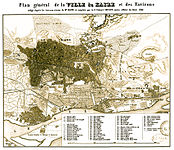
City map from 1847
· 
View over al-Qarafa, the "city of the dead", to the citadel with the still unfinished alabaster mosque (1856)
· 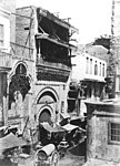
Abd-ar-Rahman Mosque (1887)
· 
1904 photographed from a balloon, on the right the new Egyptian Museum
At the beginning of the 20th century, Cairo became the cultural capital. Even the fine English society was drawn there. Until the beginning of the First World War, there was a flurry of artistic activity. On December 18, 1914, Britain officially declared Egypt a British protectorate, severing the last formal ties with the Ottoman Empire. In addition, the British enforced the war economy, which led to widespread impoverishment of the population, as the purchasing power of the British troops caused food prices to rise sharply, but on the other hand, cotton prices were sharply reduced as a result of British intervention.
When the British prevented a delegation of Egyptian nationalists led by Saad Zaghlul (Wafd Party) from travelling to the Paris Peace Conference in 1919, serious riots, strikes and a boycott of British products ensued. Under this pressure, British High Commissioner Allenby prevailed to grant Egypt independence on February 28, 1922, so that British interests could continue to be safeguarded. Cairo remained the capital of the country.
After independence
Between the world wars, Cairo's population grew rapidly and had reached the two million mark by the start of the Second World War. The growth of the population continued in the following period. The onset of a building boom transformed the cityscape with towering residential, commercial and government buildings. On March 22, 1945, the Arab League was founded in Cairo.
After "Black Saturday" on 26 January, a major fire in Cairo during the 1952 riots, Cairo's population skyrocketed, and more and more rural refugees settled there. Numerous satellite towns sprang up; a housing shortage began and the city became an unmanageable metropolis. Today, the urban area includes places that were once several kilometers away from Cairo. The city government has begun to provide incentives through cheap rents and job creation to encourage the Cairo population to relocate to the satellite towns. But for every citizen who leaves the city, two are driven to it by rural migration.
In 1994, the United Nations World Population Conference was held in Cairo. The theme of this conference was problems with which Cairo is also confronted. In addition to overpopulation, these include above all poverty and the partly catastrophic hygienic and ecological situation.
From 1992 onwards, Islamic fundamentalists in Cairo carried out repeated attacks on domestic and foreign visitors in which people were killed. One of the most serious attacks in Cairo occurred on 18 September 1997, when nine Germans and one Egyptian died in an attack on a tourist bus outside a museum. The aim of these extremist groups is to discourage tourists from travelling to Egypt in order to break the domestic stability of the country, which is dependent on foreign currency.
In 2011, protests broke out among large parts of the population in Cairo. The revolution in Egypt in 2011 was primarily directed against the authoritarian regime with its extensive security apparatus, the lack of opportunities for citizens to have a say, and corruption in the state, economy and administration. In the same year, there was an attack on the churches of Imbaba and the Maspero massacre, in which numerous members of the Coptic minority were killed.
Population development
Cairo's population has grown rapidly over the past decades. It has doubled since the mid-1960s until today. One reason for this, in addition to the high birth rate, is the increasing rural exodus. In order to be able to absorb the constant population growth, several satellite cities have been formed around Cairo over the years.
Due to the tightly drawn city boundaries, the population increase in the city has now slowed down considerably; this is mainly taking place in the numerous suburbs, which with a combined population of around 8.2 million are now as populous as the city itself with 9.1 million inhabitants (2017). Giza alone accounts for almost 2.5 million inhabitants. The Cairo metropolitan region has a total population of 16.1 million (2008). The population of the metropolitan area is expected to exceed 24 million by 2050 and 40 million by 2100.
The following overview shows the population figures according to the respective territorial status. Until 1877 these are estimates, from 1882 to 2006 census results and 2008 a calculation. The population figures refer to the governorate (Arabic Muhafaza) of Cairo and do not include the other governorates of the agglomeration, Giza and Qaliubia.
|
|
Development of the housing situation
About half of the population of the Cairo metropolitan region lives in so-called informal settlements, dwellings illegally built on the outskirts of the city by rural refugees, with inadequate infrastructure and a high population density. As a suspected place of residence for Islamic fundamentalists, they are the focus of Egyptian security policy.
While numerous people search in vain for affordable housing, several hundred thousand apartments in the region are vacant. One reason for this is that rents for old buildings are frozen at 1950s levels. The houses are therefore exposed to rapid deterioration, as the rents are not sufficient to finance the necessary repairs.
For new buildings, rents are set by the state at such a low level that either an illegal payment is demanded from the tenant before the lease is signed, which is approximately the amount of the construction costs for the apartment, or it is immediately put up for sale. The legal protection against dismissal prevents their later use by the owner.
Legally, but not statistically recorded, an almost village-like residential scene has formed on the flat roofs of many buildings. The residents have no written contract, but are tolerated. In return, they perform auxiliary services for the rent-paying residents, e.g. as caretakers. Relatives and friends live in self-built huts. Pets are also kept.
Real estate speculation in condominiums also contributes to the fact that many apartments in the region are vacant. After the reduction of state subsidies for food, energy and public transport, the poorer sections of the population cannot afford to rent or buy a condominium.
The Imbaba slum is one of the largest slums in the world.
In a 2018 ranking of cities by quality of life, Cairo ranked 178th among 231 cities surveyed worldwide.
Earthquake 1992
On 12 October 1992, an earthquake measuring 5.8 on the Richter scale struck Cairo at 15:09 local time. Around 550 people were killed by the quake. Thousands of buildings, mainly in the poor districts of the Old City, were destroyed and some 50,000 people lost their homes; valuable historic buildings such as the al-Azhar Mosque also suffered severe damage. The epicentre of the earthquake was around 26 kilometres southwest of Cairo, in the vicinity of the pyramids of Dahshur. It was the strongest earthquake in Cairo since 1847.
Recent development
→ Main articles: Revolution in Egypt 2011 and State crisis in Egypt 2013/2014
As the largest city in the Arab world and the capital of the most populous Arab country, Cairo was also a centre of the "Arab Spring" from 2010 onwards. The 2011 revolution in Egypt, which essentially took place in Cairo, led to the fall of the authoritarian regime of President Hosni Mubarak in 2011. Tahrir Square in Cairo was at the center of international news coverage, both because violent clashes between police forces and protesters took place here, and because disturbing instances of public sexual violence against women occurred here during the revolution (and continue to occur here today). After Islamic and Islamist groups such as the Muslim Brotherhood were successful in the 2011 and 2012 parliamentary and presidential elections, numerous demonstrations by political opponents again took place. In 2013, there was a military coup and the removal of the elected president from the Muslim Brotherhood, Mohammed Mursi. The 2014 presidential election was won by the military's candidate Abd al-Fattah as-Sisi, with the Muslim Brotherhood barred from participating in the election. From 2010 to 2014, the security situation in Cairo was tense and the city was rocked by mostly Islamist-motivated bombings. Before the anniversary of the Egyptian revolution in January 2014, six people died in four attacks. On 11 July 2015, one person died in a bomb attack on the Italian consulate. On 20 August 2015, a car bombing caused at least 29 injuries. On December 4, 2015, at least 16 people died in an attack on a nightclub. On 11 December 2016, a bombing at St Mark's Coptic Cathedral killed at least 25 people.


Questions and answers
Q: What is Cairo?
A: Cairo is the capital and largest city in Egypt.
Q: How is the city name Cairo translated?
A: Cairo can be translated as "the one who won."
Q: What is the nickname of Cairo?
A: Cairo is sometimes called "Mother of the World" (Um al Dunya).
Q: How many people live in Cairo?
A: Cairo has 7,947,121 people.
Q: How many people live in the urban area of Cairo?
A: About 17,290,000 people live in its urban area.
Q: Is Cairo the biggest city in the Arab World?
A: Yes, Cairo is the biggest city in the Arab World.
Q: Where is Cairo located?
A: Cairo is located on the Nile River.
Related articles
Author
AlegsaOnline.com Cairo — Capital and Cultural Centre of Egypt Leandro Alegsa
URL: https://en.alegsaonline.com/art/15997
Sources
- nytimes.com : "What's Doing in Cairo,"