Burgenland
Burgenland is Austria's easternmost and youngest federal state, known for its multicultural heritage, vineyards around Lake Neusiedl, and a history tied to the breakup of the Austro‑Hungarian Empire.
Overview
Burgenland is one of the nine federal states of the Republic of Austria and the youngest of the group, becoming part of Austria after the First World War in 1921. The region is known for its flat Pannonian landscape, extensive vineyards, and mixed cultural heritage. It is officially German-speaking while Croatian and Hungarian minorities retain recognized languages and traditions. The state's capital is Eisenstadt.
Image gallery
10 Images


Names and linguistic variety
The province has several traditional names in local languages that reflect its mixed past: the Austro‑Bavarian form Burgnlaund, the Croatian form Gradišće, and Hungarian forms such as Felsőőrvidék or Őrvidék. These names point to communities that have coexisted for centuries and to shifting state borders in Central Europe. Burgenland is part of the Republic of Austria.
Geography and natural features
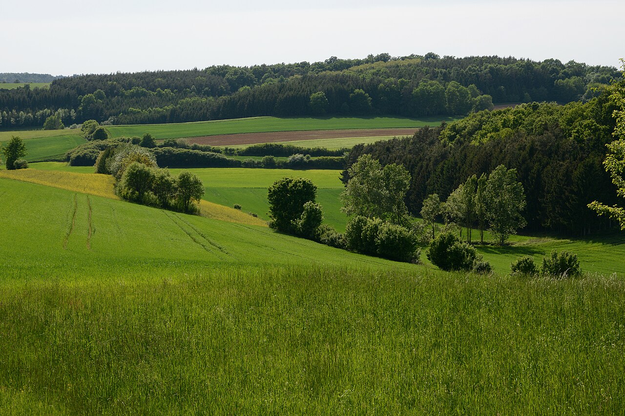
Situated on the eastern edge of Austria, Burgenland occupies a largely plain and low‑lying area of the Pannonian Basin. The shallow lake Neusiedler See (Fertő) is a defining feature of the region: its reed belts, steppe-like grasslands and flat shorelines create a distinctive landscape important for birdlife and agriculture. The climate is comparatively dry and warm for Austria, favoring viticulture and other crops.
History and political formation
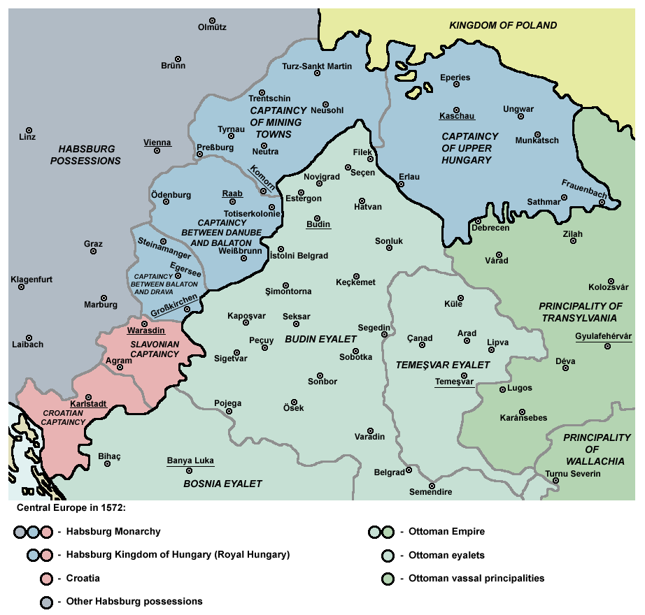
Prior to 1918 the area was part of the Kingdom of Hungary within the Austro‑Hungarian Empire. After the empire's collapse following World War I, new borders were drawn and parts of several historic Hungarian counties were transferred to Austria. Early postwar usage of the name Vierburgenland (Land of Four Castles) referred to four historic counties (Pozsony/Pressburg, Moson, Sopron/Ödenburg and Vas/Eisenburg). Since Pressburg (Pozsony) became part of Czechoslovakia, the four‑castle label was shortened; the provincial assembly formally adopted the name in the early 1920s. A 1921 plebiscite left the city of Sopron with Hungary while the remainder became the Austrian province known today as Burgenland.
Economy, culture and uses
The region's economy relies heavily on agriculture — especially wine production — tourism connected with the Neusiedler See, small industry and services. Burgenland is one of Austria's principal wine regions, producing varieties suited to sunny, dry conditions. Cultural life reflects Germanic, Hungarian and Croatian influences visible in bilingual toponyms, folk music, festivals and cuisine. Protected landscapes around the lake and cultural landscapes shared with neighboring Hungary are important for conservation and tourism.
Administration, population and notable facts
Burgenland is governed as a federal state with its own provincial assembly and administration; Eisenstadt serves as the seat of government. The population is predominantly German-speaking, with longstanding Croatian and Hungarian minority communities that enjoy language rights and cultural recognition. Notable attributes include the cross‑border Fertő/Neusiedlersee cultural landscape, important bird habitats, and a history that illustrates the territorial changes in Central Europe after World War I.
- Capital: Eisenstadt.
- Key attractions: Neusiedler See, wine districts, rural cultural festivals.
- Historical note: integration into Austria occurred in the immediate post‑World War I period.
Geography
Burgenland has an area of 3,965.2 km² and shares a 397 km long state border with Hungary for the most part, and also with Slovenia and Slovakia in small parts.
The highest elevation in Burgenland is the 884 m high Geschriebenstein (Írott-kő), through the summit of which the state border runs. The lowest point is Hedwighof (municipality of Apetlon - district of Neusiedl amSee) at 114 m. Lowest municipality is Illmitz with 116 m.
The geographical center of Burgenland, (coordinates: 47° 28′ 41.2″ N, 16° 34′ 17.8″ E47.478116.5716) is located in Unterpullendorf (municipality of Frankenau-Unterpullendorf) and was marked by geographers of Burgenland by the "Mittelpunktstein" (basalt stone from the Pauliberg). In the south, Riedel are characteristic of the landscape.
Natural classification
Burgenland is divided into three regions, with the Mittelburgenland sometimes being classified as part of the Südburgenland.
- North Burgenland
- Mittelburgenland
- South Burgenland
North Burgenland
The northern part of Burgenland, north of the Ödenburg Mountains, is largely part of the Pannonian Plain and includes the free cities of Eisenstadt and Rust as well as the districts of Eisenstadt-Umgebung, Mattersburg and Neusiedl am See. Here lies Lake Neusiedl, a steppe lake surrounded by a wide belt of reeds, the "Sea of the Viennese". Nearby, the Lange Lacke nature reserve provides a refuge for rare bird species. In 1992, the Lake Neusiedl-Seewinkel National Park was established in this area, which is continued across the border in the Hungarian Fertő-Hanság National Park.
Mittelburgenland
The Mittelburgenland, consisting of the district of Oberpullendorf, on the other hand, is hilly and is separated in the south by the Günser Mountains, where the 884-metre-high Geschriebenstein is located, from the likewise hilly Südburgenland. Characteristic for the Mittelburgenland is the loamy soil. In between there are some hills made of basalt, which are part of the extinct Transdanubian volcanic region. The entire area is drained by the Rabnitz River, which flows eastward to the Danube.
South Burgenland
Südburgenland consists of the districts of Güssing, Jennersdorf and Oberwart. The hilly terrain slopes down from the East Styrian Hills and the Günser Mountains towards the southeast. The highest elevations in this part south of the Günser Gebirge range only just above 400 metres above sea level. The south is dominated by the river Raab and its many tributaries.
Rivers
Almost the entire area of Burgenland drains into the Danube via the Raab. While Lake Neusiedl is tributary via the Einserkanal, in southern Burgenland the Pinka and the Raab itself determine the waters. In the far north, the Leitha forms the historical border river to Lower Austria. The Wulka rises in the Rosalien Mountains and flows into Lake Neusiedl. The Zöbern is a left tributary of the Güns and flows into it in the Burgenland market town of Lockenhaus. The Tauchenbach or Tauchen (Hungarian: Tava) is a tributary about 40 km long, which flows into the Pinka on the left side.
Climate
Burgenland shares the Illyrian climate in southern Burgenland and the Pannonian climate in the remaining parts of the country. The central and northern parts of Burgenland are more continental than the southern parts. The average temperatures here are between -2 °C and -4 °C in January and about 21 °C in July.
On 8 August 2013, a new Burgenland temperature record was set in Neusiedl am See with a maximum temperature of 40.3 degrees Celsius.
Nature Conservation
In Burgenland, various levels of protection have been established to preserve habitats or landscapes. An important objective is also diversity, individuality, beauty and the recreational value of nature and landscape. this protection comprises several protection areas or levels, some objects or areas are wholly or partly in several categories:
- There is one national park, the Neusiedler See-Seewinkel National Park, which forms the Austrian part of the UNESCO World Heritage Cultural Landscape Fertő/Neusiedler See.
Furthermore, there are:
- 29 nature reserves, see also List of nature reserves in Burgenland
- 8 landscape protection areas, see list of landscape protection areas in Burgenland
- a protected landscape area, see also List of protected landscape areas in Burgenland
- 15 European protected areas, see also List of European protected areas in Burgenland
- 5 protected habitats, see also List of protected habitats in Burgenland
- 6 nature parks (list for the whole of Austria)
Management structure
Burgenland consists of 171 independent municipalities and is divided into seven political districts and the two free cities of Eisenstadt and Rust. In 2019, Burgenland had the lowest average number of inhabitants per municipality of all the provinces of Austria, with an average of only 1716 inhabitants per municipality, see also Municipalities of the States of Europe. All of Austria had an average of 4227 inhabitants per municipality in 2019.
→ Main article: List of political districts in Burgenland and List of municipalities in Burgenland
| Districts and Free Cities (from north to south) | |||
| Name | Area (km²) | Inhabitants | Vehicle registration number |
| 1.038,64 | 60.397 | ND | |
| 453,14 | 43.861 | EU | |
| 42,88 | 14.895 | E | |
| 20,01 | 2.000 | E | |
| 237,83 | 40.316 | MA | |
| 701,44 | 37.453 | OP | |
| 732,58 | 54.209 | OW | |
| 485,34 | 25.770 | GS | |
| 253,34 | 17.109 | JE | |
| Municipalities with more than 3,500 inhabitants | ||||
| Rank | Name | Status | Inhabitants | District |
| 01. | Freistadt | 14.895 | E | |
| 02. | Neusiedl am See | Municipality | 8.643 | |
| 03. | Oberwart | Municipality | 7.662 | |
| 04. | Mattersburg | Municipality | 7.538 | |
| 05. | Pinkafeld | Municipality | 5.882 | |
| 06. | Parndorf | Community | 5.062 | |
| 07. | Neudörfl | Market town | 4.788 | |
| 08. | Jennersdorf | Municipality | 4.121 | |
| 09. | Gols | Market town | 3.944 | |
| 10. | Güssing | Municipality | 3.665 | |
| 11. | Großpetersdorf | Market town | 3.549 | |


History
→ Main article: History of Burgenland
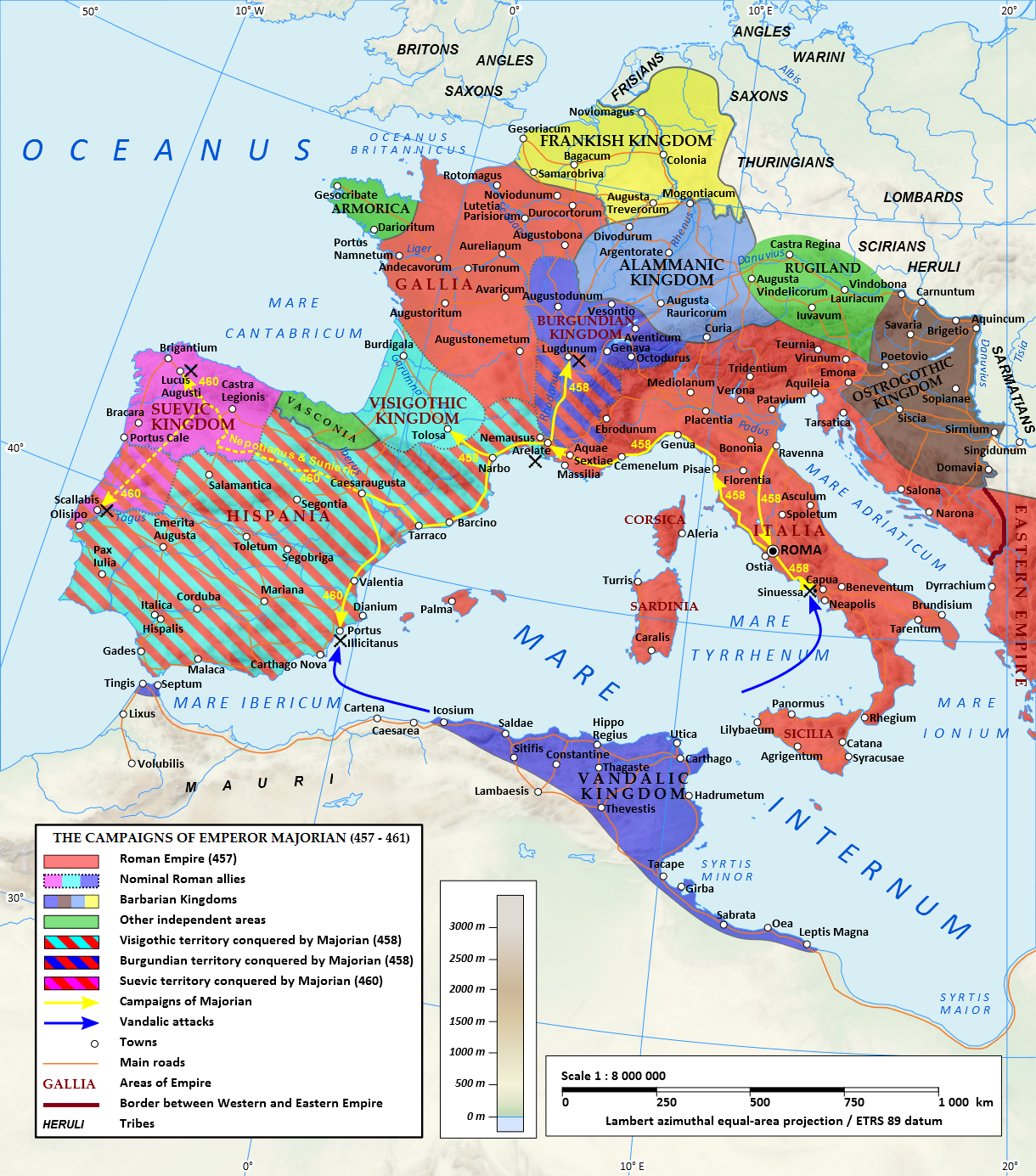
Around 400 BC the Celts settled in the area of today's Burgenland. Around the time of Christ's birth, Burgenland became part of the (ancient) Roman Empire; its territory belonged to the province of Pannonia. Roman rule ended in 378 AD, after which the land was settled by the Ostrogoths. From 433 to 453 AD the Huns ruled here. In the year 454 the later Ostrogothic king Theoderich the Great was born in the area of Lake Neusiedl. The Huns were followed by the Lombards from 490 to 568. From 600 to 800 the country was ruled by the Avars. At the end of the 8th century, the Frankish king Charlemagne defeated the Avars and the land was incorporated into the Frankish Empire as part of the Avar Margraviate. After 800 the first German settlement took place under Charlemagne. In the 9th century it was part of the Slavic Balaton principality and the Great Moravian Empire. In 907 the Magyars conquered the country.
Around 1260 the counts of Güssing owned 25 castles in the area. The Mattersdorf-Forchtenstein counts, who came from Aragon in Spain, also held large estates in what is now northern and central Burgenland. At the time of the first Vienna Turkish siege in 1529, the villages of the Seewinkel were devastated. Around 1530 Croats were settled in what is now Burgenland. The area, which had been predominantly German-populated since the Turkish Wars, was part of the Kingdom of Hungary and had been leased by the Hungarian kings in the Middle Ages to the Habsburgs as archdukes of neighbouring Austria under the Enns and as dukes of Styria, which was also adjacent. When Habsburg inherited the Hungarian royal crown in 1526, this lease became obsolete. In 1622 Nikolaus Esterházy was enfeoffed with the dominion of Forchtenstein, and in 1648 with Eisenstadt.
From 1648 to 1921 the area was under Hungarian administration. In 1664 the country suffered from the Turkish War, and in 1678 from the Kuruc War. At the time of the second Vienna Turkish siege, northern Burgenland was once again badly hit.
After the Austro-Hungarian Compromise of 1867, the area later called German West Hungary was also subjected to the Magyarization that began throughout Old Hungary, i.e. the attempt to successively turn the non-Magyar peoples of the Kingdom of Hungary, who made up about 50% of the total population, into Magyars (Hungarians) or to assimilate them. This was opposed to the right of self-determination of the peoples of the Danube Monarchy demanded by Woodrow Wilson at the end of the First World War.
After the disintegration of Austria-Hungary in 1918, the newly founded state of German Austria claimed, among other things, the German-speaking part of western Hungary for itself. In the Treaty of St. Germain concluded between Austria and the victorious powers of the First World War, the territory was granted to Austria in 1919; Hungary had to undertake to cede it in the Treaty of Trianon in 1920. After the establishment of the short-lived Republic of Lajtabánság under the leadership of the free-army commander Pál Prónay in October 1921, the territory was occupied by the Austrian army the following month and officially handed over by Hungary to Austria on 5 December 1921. The attitude of the German-speaking settlers in western Hungary towards the annexation to Austria was (more likely) inconsistent for economic reasons. After strong protests from Hungary, a referendum was held in December 1921 for Ödenburg (Hungarian: Sopron), which was intended to be the capital of the new province, and its surroundings, which resulted in Ödenburg remaining with Hungary. The overall result of the referendum was a clear two-thirds majority in favour of remaining part of Hungary, as a large number of voters were drawn from the interior of the country. The municipalities around Ödenburg voted for Austria (but still remained with Hungary, as the voting area was only counted as one unit); the majority of the population in the city of Ödenburg voted to remain with Hungary.
The incorporation of the Province into the Republic of Austria was regulated in the Federal Constitutional Law on the Status of Burgenland as an Independent and Equal Province in the Federation and on its Provisional Establishment of 25 January 1921.
Some advocates of the incorporation into the Republic of Austria propagated the country name Heinzenland (after the Hianzn dialect, see also the short-lived Republic of Heinzenland), but the proposal Burgenland finally prevailed.
The takeover of Burgenland into Austrian administration took place in the autumn of 1921. Bad Sauerbrunn was the provisional seat of the provincial government and administration until 1925; then the small town of Eisenstadt (Hungarian: Kismarton), which had been relatively insignificant until then, was designated the capital of Burgenland.
In the "Greater German Reich" after the "Anschluss" of Austria, the cities of Eisenstadt, Rust and the districts of Eisenstadt, Mattersburg, Neusiedl am See and Oberpullendorf were assigned to the Reichsgau Niederdonau as of 15 October 1938, the districts of Güssing, Jennersdorf and Oberwart to the Reichsgau Steiermark.
After the end of the Second World War and the re-establishment of the Republic of Austria in 1945 (Second Republic), Burgenland also re-emerged as a federal province. Until 1955 it lay in the Soviet occupation zone, until 1989 the Iron Curtain existed on its eastern border.
Name
The name "Burgenland" is a reminder that the country is made up of parts of three old Hungarian counties, all of which had "castle" in their names. A curious fact is that none of the three castles giving the name is located in today's Burgenland. They are all located on Hungarian territory:
- Wieselburg (Moson)
- Ödenburg (Sopron)
- Eisenburg (Vas)
At the beginning of 1919, Austria also claimed parts of Pressburg County (Slovak Bratislava, Hungarian Pozsony) for Burgenland. Therefore, in June 1919, the name "Vierburgenland" was proposed. In mid-August 1919, however, it became apparent in the peace negotiations that Pressburg would go to Czechoslovakia. Karl Renner recommended from Saint-Germain that the name be changed to "Dreiburgenland".
The name "Burgenland" was allegedly proposed for the first time by Gregor Meidlinger from Frauenkirchen, on September 6, 1919, after a German-Western Hungarian delegation had presented the name to State Chancellor Karl Renner. This name became common at the latest with the Federal Constitutional Law on the Status of Burgenland as an Equal Federal Province of January 25, 1921.
Population
Since Burgenland was traditionally economically backward, many Burgenlanders emigrated to big cities and to America, so that Vienna and Chicago are the cities with the largest "Burgenland" population, ahead of Eisenstadt.
| Languages in Burgenland (15 May 2001) | |
| Language | Share |
| German | 90,7 % |
| 06,1 % | |
| 01,8 % | |
| 00,4 % | |
| Romanes | 00,1 % |
| <0,1 % | |
| Other | 00,9 % |
In the 2001 census, 19,374 people throughout Austria stated that they spoke Burgenland-Croatian, with 16,245 residing in Burgenland itself. According to the self-assessment of the ethnic group itself, their number amounts to 40,000. In addition, there were 4,704 Burgenland Hungarians (self-assessment 25,000). 263 gave Romanes as their colloquial language. The real number of Burgenland Roma, however, is probably also considerably higher.
The various ethnic groups are legally recognised as autochthonous language groups. The Croatian and Hungarian Burgenlanders as well as the Sinti and Roma are therefore entitled to use their languages in public correspondence. On the basis of a decision of the Council of Ministers of 23 May 2000, place-name signs with bilingual inscriptions German/Croatian (47 places) or German/Hungarian (4 places) were erected in places or parts of places with a proportion of at least 25% bilingual population (in the 1991 census). Their existence as well as the high 25% limit are no longer controversial in Burgenland today - in the 1970s there were also heated debates about this, but the discussions about bilingual place-name signs never reached the level of escalation that was reached in the place-name sign dispute in Carinthia.
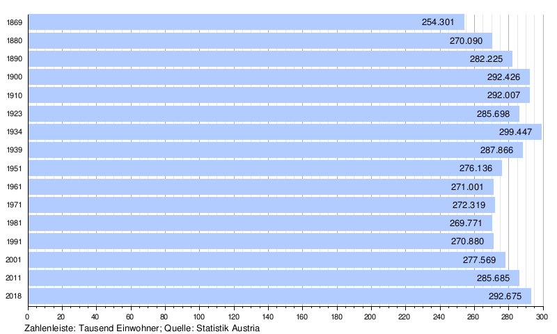
Population development
Religion
Although the majority of Burgenlanders are predominantly Roman Catholic, as in the rest of Austria, there is a relatively high proportion of Protestants here, 14%, who are organised in the 29 parishes of the Superintendent's Office A. B. Burgenland and in the Protestant parish H.B. Oberwart.
There used to be a large and significant Jewish culture, especially in the so-called "seven communities" (Eisenstadt, Mattersburg, Kittsee, Frauenkirchen, Kobersdorf, Lackenbach as well as Deutschkreutz) with a high proportion of Jewish population. In Lackenbach, 62% of the population were Jewish in 1869; the largest Jewish community in Burgenland, however, was that in Mattersburg. By the end of the 19th century Jews made up more than a third of the inhabitants here. In 1938 all Jews were expelled from Burgenland or murdered, and today there is very little to remind us of the former Jewish life in Burgenland.
The patron saint of Burgenland is St. Martin of Tours.


Questions and answers
Q: What is Burgenland?
A: Burgenland is one of the nine federal states of Austria.
Q: When did Burgenland become a part of Austria?
A: Burgenland became a part of Austria after the First World War in 1921.
Q: What is the meaning of the name Vierburgenland?
A: The name Vierburgenland means Land of Four Castles.
Q: Where did the name Vierburgenland come from?
A: The name Vierburgenland was derived from the name of the four counties of the Kingdom of Hungary.
Q: What are the four counties that the name Vierburgenland was derived from?
A: The name Vierburgenland was derived from the four counties of the Kingdom of Hungary known in German as Pozsony, Moson, Sopron and Vas or in German as Pressburg, Wieselburg, Ödenburg and Eisenburg.
Q: Was the name Vierburgenland changed after Pressburg was given to Czechoslovakia?
A: Yes, the number was dropped from the name Vierburgenland after Pressburg was given to Czechoslovakia.
Q: When was the name Vierburgenland adopted by the province assembly?
A: The name Vierburgenland was adopted by the province assembly in 1922.
Related articles
Author
AlegsaOnline.com Burgenland Leandro Alegsa
URL: https://en.alegsaonline.com/art/15405
Sources
- burgenland.at : Landeshauptmänner