Brugg — Swiss town in Aargau: overview, history and key features
Brugg is a municipality in the Swiss canton of Aargau, serving as the capital of its district. Known for its medieval bridge origin, Roman nearby remains, transport links and recent municipal mergers.
Overview
Brugg is a town in the Swiss Confederation located in the canton often referred to simply as Swiss Aargau. It functions as the administrative centre of the district of Brugg and sits in a region where transport routes and rivers have long influenced settlement and commerce. The town's name derives from the German word for "bridge," reflecting its historic role as a river crossing.
Image gallery
10 Images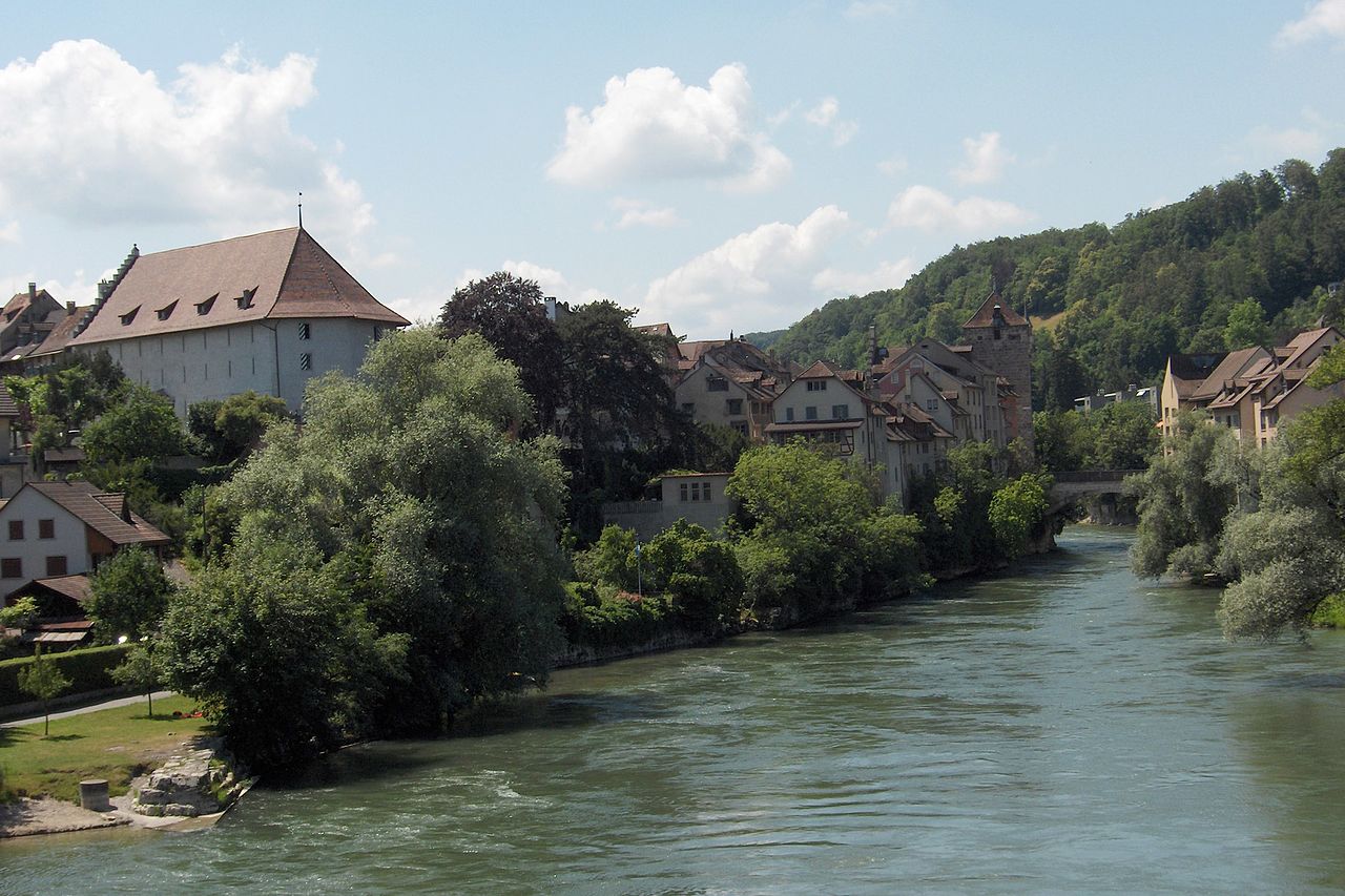


Geography and name
Brugg occupies a compact area at a strategic point on regional roads and rail lines, close to significant waterways in Aargau. Its position made it a natural meeting point for traders and travellers and explains the origin of the town's name. The surrounding landscape mixes urban streets with agricultural patches and woodlands common to this part of northern Switzerland.
History and origins
The locality shows continuity from antiquity: a Roman military presence was established nearby and later medieval development clustered around the bridge that gave the town its name. Over centuries Brugg evolved from a market settlement into a small administrative and service centre, while retaining several older buildings and street layouts that reflect its long history.
Administration and recent changes
Brugg is the seat of the local district administration and has expanded in recent decades by merging neighbouring municipalities. In 2010 the former community of Umiken joined Brugg, and on 1 January 2020 the spa municipality of Schinznach-Bad was incorporated. These changes reflect a regional trend toward consolidation of local government and services.
Economy, transport and culture
The town acts as a regional transport junction with rail connections and highways linking larger Swiss cities, which supports light industry, services and commuting. Cultural life is anchored by museums and historic sites that interpret the Roman and medieval past; local festivals and markets underline Brugg's role as a community hub. Visitors often use Brugg as a base to explore the wider Aargau area and its heritage.
Notable facts
- Administrative centre of the district of Brugg.
- Name reflects an historic bridge and crossing point.
- Nearby Roman remains are an important part of local identity and interpretation.
For further official information, local history or administrative matters, consult municipal and cantonal resources linked from the town's web pages and regional guides.
Geography
The urban area stretches from southwest to northeast in the Aare valley over a length of more than nine kilometers, but its maximum width is little more than one kilometer. The Aare separates two differently shaped landscapes, the Swiss Plateau on the south side and the Tabular Jura on the north side. The river has a gradient of about twenty metres over the approximately twelve-kilometre stretch in the municipal area of Brugg.
To the southwest, on the right bank of the Aare, lies the village of Schinznach-Bad, a district of Brugg since 2020. The headrace canal of the Wildegg-Brugg power station, which is located in the municipality of Villnachern, begins at Schinznach-Bad. Alongside the canal, the "Wildischachen" area, characterised by floodplains on the old course of the Aare, extends over a length of several kilometres. To the east, the Wülpelsberg rises above the river valley, with Habsburg Castle at its highest point. At Altenburg, the underwater channel of the Wildegg-Brugg power station rejoins the old course of the Aare north of the wooded "Schacheninsel", which is dammed by an auxiliary weir. After a bend around the Altenburg rock, the Aare flows eastwards through a 200-metre-long gorge with rapids, where the former municipal power station stands and where the Süssbach flows into the Aare. The river, which is otherwise up to 130 metres wide, passes next to the old town of Brugg through a deep cut in the limestone rock, only twelve metres wide, over whose narrowest point the old bridge runs.
East of the old town, the Aare leaves the narrow gorge and flows at the Casino Bridge into the wide plain of the Schachen area. It passes the "Aufeld" plain on the southern edge. A narrow side arm, in which the municipal boundary runs, separates the "Geissenschachen" island from the plain. Below the island, larger remnant areas of floodplain forest lie on both sides of the river. From Auschachen, a pipeline bridge leads across the Aare to the sewage treatment plant, which lies in the middle of the forest area. At Auhof and downstream of the Vogelsang bridge, new side arms were built in the Schachen area in 1988-1989 to improve the dynamic development of the floodplain.
Switzerland's water castle is located on the eastern city border. Three of the country's most important rivers flow together here: First, the Reuss flows into the Aare, and one and a half kilometres further north, the Limmat. In the far northeast, at a narrow point between the Reinerberg (522 m above sea level) and the mouth of the Limmat, lies the village of Lauffohr.
North of the Aare, settlement from Umiken to Lauffohr is concentrated on a narrow strip along the southern flank of the wooded Bruggerberg (516 m above sea level). The plain south of Altenburg is almost completely covered with residential and commercial buildings and sports facilities as far as the cantonal road. In the southeast, the settlement of Brugg has grown together with that of Windisch.
The municipality covers an area of 636 hectares, of which 174 hectares are forested and 334 hectares are built over. The highest point is the Bruggerberg at 516 metres, the lowest is at the mouth of the Limmat at 328 metres.
The neighbouring municipalities of Brugg are: Riniken and Rüfenach to the north, Villigen to the northeast, Untersiggenthal and Gebenstorf to the east, Windisch to the southeast, Hausen, Habsburg, Lupfig and Holderbank to the south, and Schinznach, Veltheim and Villnachern to the west and Bözberg to the northwest.
Until the beginning of the 19th century, the town's territory comprised only a tenth of the current municipal area. In 1823, the town of Brugg bought around a quarter of its area from the neighbouring municipality of Lauffohr, and in 1827 it acquired several plots of land from the village of Umiken. In 1863, the municipality of Windisch sold the area around the railway station to Brugg and also ceded the Gaswerkareal and the western tip of the Geissenschachen on the Aare to it in 1912. Altenburg was incorporated in 1901 and the municipality of Lauffohr in 1970. Umiken became part of the city of Brugg in 2010, and since 2020 the area of the previously independent municipality of Schinznach-Bad has also belonged to the city area, according to the 2018 municipality agreements.


History
Before the founding of the city
Finds from prehistoric times are sparse: two blades and fragments of a stone axe from the Neolithic period and a sickle from the Bronze Age. In 58 BC (or shortly afterwards), the Helvetii, who had returned to the Mittelland after the Battle of Bibracte, founded the settlement of Vindonissa on the hilltop between the Aare and Reuss rivers, on the territory of the neighbouring municipality of Windisch.
The Romans built a military station around 15 BC, which they expanded into a legionary camp from 14 AD. Chr. they extended it to a legion camp. The first wooden bridge over the Aare was built at this time, and the Roman road to Augusta Raurica (Augst) led over it. It was the only place between Lake Thun and the mouth of the Rhine where the Aare could be bridged with a single tree trunk. There were two large cemeteries on Brugg soil. So far, around 350 Roman graves from the 1st century AD have been discovered. Archaeologists estimate the total number at around 7000.
After the invasion of the Alamanni (259 to 270), Vindonissa was again converted into a legionary camp after a period of almost 170 years of civilian settlement. In today's Altenburg district, a fort was built around 370 as a base in the hinterland of the Danube-Iller-Rhine limes. Between 401 and 406 the Romans finally withdrew from the Rhine area. The settlement of Alemanni in the Aargau area can be traced from the 7th century onwards.
In the late 10th century, a noble family settled in Altenburg, possibly descended from the Alsatian Etichones. Count Lanzelin had the fort extended to become Altenburg. Around 1020, his son Radbot ordered the construction of the Habsburg on Wülpelsberg, three kilometres to the southwest. A few decades later, the dynasty named itself after this castle. Altenburg was thus the first verifiable Habsburg residence. With the acquisition of the Eigenamt between the Aare and Reuss rivers, they laid the foundation stone for their territory.
seat of power of the Habsburg dynasty
The earliest documented mention of Bruggo was in 1064, when Count Werner I confirmed the ownership of estates in the area to the Muri Monastery. The exact date is disputed because the Acta Murensia was not produced until around 1160 and brought together various older documents. The place name comes from the Old High German (ze) brucco and means "at the bridge(nstelle)". At the end of the 12th century, the Black Tower, the oldest surviving building in the old town, was built on the orders of Count Albrecht III.
In the 13th century, the fortified bridge settlement took on more and more small-town features. From 1232 coins were minted, in 1273 there was the first mention of a customs office, from 1278 at the latest there was a Schultheiss and in 1283 the market was mentioned for the first time. The importance of Brugg for the Habsburgs at that time is shown by the fact that they moved out of Habsburg, which had become too small in the meantime, around 1220/30 and then lived in Brugg. In 1242, the town is said to have been plundered by followers of the Habsburg-Laufenburg side line.
Rudolf I, who had often stayed in Brugg before his election as Roman-German king, granted the town charter on 23 June 1284. At the same time he detached Brugg from the Eigenamt. Brugg's town charter corresponded word for word to that of Aarau. Although the Habsburgs' centre of power had shifted to Vienna a few years earlier, the relationship with Brugg remained close. The "Österreich-Haus" (later the "Effingerhof") served as a lodging house and headquarters during military conflicts in the Austrian foothills.
On 1 May 1308, King Albrecht I was murdered near the neighbouring village of Windisch. To commemorate this event, his wife Elisabeth of Gorizia-Tyrol founded the Königsfelden Monastery (200 metres from the town boundary). Albrecht's eldest daughter Agnes of Hungary, the widow of the Hungarian King Andreas III, lived there from 1317 and led the monastery to economic prosperity. In 1348 she received from her brother Albrecht II the lordly rights over the town of Brugg as well as over the neighbouring offices of Bözberg (with Lauffohr) and Eigenamt (with Altenburg). These rights reverted to the Dukes of Habsburg-Austria after her death in 1364.
Although the town was firmly in the hands of the Habsburgs, there were beginnings of an independent policy. For example, Brugg concluded castle law treaties with Baden and Mellingen (both 1351) and with the monastery of Wittichen in the Kinzigtal (1353). The Bözberg and Eigenamt offices came under the military command of the town in 1364. Several times Austrian military leaders assembled their forces in Brugg, for example Duke Leopold III in 1386 before the Battle of Sempach.
15th century
Duke Frederick IV fell out of favour at the Council of Constance in 1415 after helping the antipope John XXIII to escape. King Sigismund then called on the Confederates to conquer Aargau in the name of the Empire. Bern did not hesitate for long and immediately sent troops. The people of Brugg allowed the Bernese to march into their town without a fight on 29 April 1415. In return, the town's traditional rights remained untouched.
The town and the Eigenamt now lay in the extreme northeast of the Bernese subject territory, the Bernese Aargau. After the Battle of Sempach, the Habsburgs had pledged the dominion of Schenkenberg, which had emerged from the office of Bözberg, to retainers. This resulted in a legally complicated situation for Brugg, because the suburb and the forest on the Bruggerberg lay north of the Aare and thus outside Bern's jurisdiction. Brugg therefore always had to come to an arrangement with the respective owners of the Schenkenberg dominion.
King Frederick III allied himself with Zurich in 1443 in the Old Zurich War and demanded the return of Aargau. The people of Brugg hoped for an upswing from the return of the Austrian rulers, because since the conquest by Bern, economic momentum had slowed considerably due to the border situation. When Zurich was besieged by the troops of the other Confederates in June 1444, the French king Charles VII sent the Armagnacs. To facilitate their passage to Zurich, Brugg was raided in the night of 29-30 July 1444. A small force led by Baron Thomas von Falkenstein crept up from the Bruggerberg, entered the town by trickery, plundered all the houses and set fire to some of them. Numerous townspeople were kidnapped and later released for ransom.
Although this event claimed only a few lives, Zurich's opponents hyped it up into a veritable massacre and called it the "Brugg Murder Night". In retaliation, the Bernese and Solothurners destroyed the Falkenstein castle near Niedergösgen a few weeks later. The Armagnacs were stopped at the battle of St. Jakob on the Birs. The raid on Brugg thus subsequently proved to be completely useless from a strategic point of view. On September 5, 1445, Zurich troops again planned an attack on the town; however, they were discovered early and repelled, whereupon they pillaged the surrounding villages.
In 1451, Thüring von Aarburg sold the lordship of Schenkenberg to Hans and Markwart von Baldegg. Between Brugg and the Baldeggers there were more and more disputes about rights of use on the Bruggerberg. The Baldeggers, who had demonstratively allied themselves with Austria, regarded the area north of the Aare as their personal property and resented the rights of the town. Bern finally had enough of the constant harassment of their subject town and conquered the Schenkenberg dominion in 1460. Now the inhabitants of the villages north of Brugg had also become Bernese subjects. However, this did little to change the peripheral situation, as the border had merely been moved a few kilometres to the north. The warlike conflicts had a lasting impact on the town's economic power. In the eighty years following the "Brugg Murder Night", the population decreased by almost half, and surrounding towns were able to expand the catchment area of their markets at the expense of Brugg.
In the Bern area
Within the state of Bern, Brugg occupied a special position as a "municipal town". Brugg was not assigned to a bailiwick and enjoyed a great deal of autonomy. The town was headed by two Schultheisse (mayors) who alternated every two years. Together with seven other people, they formed the "Small Council", which took over the various administrative tasks. Below them stood the "Great Council" with twelve members, which exercised a supervisory function. All the councillors came from the ranks of the 32-member "Small Council". Its members, however, were all appointed by the Small Council itself, so that candidates who did not like it had no chance of obtaining higher political offices, except by bribery. A few influential families divided the lucrative posts among themselves. The disempowered citizenry had only the right to elect the parish priest. The "Maiding", the citizens' assembly, had a purely symbolic character.
In January 1528 Bern decided to introduce the Reformation. In all towns and bailiwicks, votes were held to choose the denomination. While the neighboring bailiwicks voted for the Reformation, there was a majority of five votes in favor of remaining Catholic in Brugg on March 1. But Brugg was isolated on this issue and had to bow to massive political pressure from Bern a few days later.
The municipal school, which had existed at least since 1396, was converted into a magisterial Latin school after the Reformation. It served mainly to prepare students for the theological academy in Bern. It was financed by income from the dissolved Königsfelden monastery. The Latin school produced an above-average number of pastors and scholars, which is why Brugg was nicknamed the "Prophet City".
Despite its subject status, the town repeatedly tried to extend its own influence to surrounding areas. Since the 13th century, it held the patronage of the church in Mönthal. In 1588 Johann Georg von Hallwyl, later Bishop of Basel, sold two thirds of the parishes of Bözberg and Rein to the town, as well as one third of the lower jurisdiction in Villnachern. Brugg also acquired the lordship of Trostburg in the Wynental from the Hallwyls in 1616. Bern, however, did not tolerate the increase in power of its subject city and seized the lordship rights.
During a plague epidemic in 1541, about 180 people died, a quarter of the population. By 1611 the population had risen again to a peak of 930, about the same as almost two hundred years before. The last and most serious plague epidemic lasted from September 1667 to January 1669, when 514 people died, or over 60 percent of the population. A serious accident occurred on 1 September 1626, when a ship sailing on the Aare towards Zurzach capsized. More than 100 people drowned, 47 of them from Brugg. It was not until around 1840 that the population returned to that of 1611.
From time immemorial, craftsmanship was predominant in the town's economic structure. It was primarily geared to the needs of the surrounding population, and with the increasing expansion of the transport routes also to those travelling through (especially after the construction of the new Bözberg pass road between 1773 and 1779). There were no guilds with political influence. In the 18th century, the salt trade became very important. The salt house, built in 1732, was one of the largest salt depots in the Confederation, supplying not only Bernese Aargau but also the county of Baden and the Free Offices.
Revolutionary years
→ Main article: Helvetic Revolution in Brugg
The political demands for equality and human rights after the beginning of the French Revolution were very popular in Brugg. But the authorities feared for the loss of their influence and forbade public discussions on the subject. For this reason, interested citizens began meeting in 1796 in a club with the code name "Billiard Club". In this club, the ideas of the French Revolution were discussed and how they could be transferred to Brugg.
As the French troops advanced further and further at the beginning of 1798 and the end of Bernese rule was in sight, a revolutionary committee took power in Brugg. After the French troops led by General Guillaume-Marie-Anne Brune marched into Bern on March 5, the delegates of the large cantons constituted the Helvetic Republic in Aarau on April 12.
19th century
In the Helvetic central state, the cantons were purely administrative units, further divided into districts and municipalities. Brugg lost all its prerogatives and was now the district capital in the canton of Aargau. The revolutionary mood quickly faded. This was mainly due to the Second Coalition War in 1799, when the front ran through the Aare valley and hundreds of French soldiers were quartered in the town's houses. When the French withdrew from Switzerland for a few months in 1802, supporters of the old order had the upper hand. During the Steckli War, peasants from the surrounding area looted the armoury. With the Act of Mediation signed by Napoleon Bonaparte on 19 March 1803, Brugg finally became the district capital of Canton Aargau.
At the beginning of the 19th century, Brugg became a stronghold of liberalism. Brugg politicians played a leading role in the establishment of the new canton. As an outward sign of the spirit of optimism, the town moat was filled in in 1811 and almost all the fortifications were demolished between 1829 and 1840. The steep gradient of the main street, the most important road through the old town, hindered carts and was levelled in 1836 under the direction of the later world-famous engineer Alois Negrelli von Moldelbe. In 1823 Brugg concluded a contract with Lauffohr: For 1669 francs, the neighboring municipality sold about a quarter of its territory. In 1827, the town of Umiken acquired the land near the Brunnenmühle near the suburb in exchange for rights to wood and fields in the "Umiker Schachen".
The initially positive basic mood towards the challenges of modernity gave way to a preservationist mentality and the people of Brugg concentrated on their supposed strengths of crafts, trade and commerce. The political will was lacking for the establishment of industry. The Bruges bourgeoisie also harboured prejudices against factory workers. Neighbouring villages such as Windisch and Turgi, where large textile factories were established, benefited from this hesitation.
The Swiss Northeast Railway extended the Zurich-Baden railway line, Switzerland's first railway, to Brugg on 29 September 1856. The cantonal capital Aarau was reached on 15 May 1858. Economically, the railway initially brought disadvantages, because the haulage business, which lived from transit traffic over the Bözberg Pass, largely collapsed. The people of Brugg also complained that the railway station was too far away (ten minutes' walk), causing additional damage to the town. The people of Windisch, on the other hand, complained that the station was called "Brugg" even though it was on their municipal territory.
The cause of this dispute was the complicated boundary between the two communities. Only the "Burgerziel", a narrow strip of land around the former city wall, belonged to the city. To the south of this was the "Ehfäde", a special district used for agricultural purposes, which was entirely privately owned by Brugg citizens. Although all changes of ownership had to be approved by Brugg, the area belonged fiscally and politically to Windisch. The town had repeatedly tried in vain to appropriate the Ehfäde. In 1856, the cantonal government decided that the existence of two different municipal boundaries was no longer appropriate and assigned the Ehfäde to Windisch. However, the neighbouring municipality was in financial difficulties and in 1863 sold this area, on which the railway station had been built in the meantime, to Brugg for 25,000 francs.
The construction of two further lines made Brugg a railway junction: the Bözbergbahn to Basel opened on 2 August 1875, and the Aargauische Südbahn put the line to Hendschiken into service on 1 June 1882. Although excellent transport links and sufficient building land were now available, industry was still slow to develop. In 1864 a printing works was built, but the "Effingerhof", the former town residence of the Habsburgs, had to make way for its construction. Another prominent building, the Hallwyler Fortress, was demolished in 1883 and replaced by a school building. In 1882 the new water supply system was built, in 1892 the municipally owned Brugg power station, from 1896 the sewage system, and in 1911 the gasworks.
The town's military tradition was established in 1848. The pontoon troops stationed here exercised in the old town and were initially housed in private houses. After numerous complaints, the cantonal government decided in 1856 to convert the former granary into barracks. Between 1876 and 1878 a military training area was built at "Geissenschachen" and in 1898 a new barracks complex. Brugg thus became the centre of the Swiss genius troops.
20th century
→ Main article: Industrialisation of the town of Brugg
The breakthrough in industrial development did not come until 1892 with the commissioning of the municipal power station on the River Aare, which was in operation until 1952. In quick succession, numerous industrial companies settled here and Brugg experienced an economic boom. Soon, however, the town again felt the disadvantages of the narrow confines of the urban area. Between 1898 and 1901, twelve small municipalities in the canton of Aargau were amalgamated against their will, as they did not seem economically viable and could not fulfil the legally prescribed tasks. Altenburg was also affected by this development. Although the municipal assembly voted against it by 42 to 2, the incorporation into the town of Brugg was carried out on 1 January 1901 in accordance with the decision of the Grand Council of the Canton of Aargau. Brugg was thus able to double its area.
Agriculture had never played a significant role in the past, but various circumstances led to the rise of Brugg as a "farming metropolis" at the turn of the century. The "Agricultural Winter School", a training and further education centre for farmers, was opened in 1887 and moved into a new building on Baslerstrasse in 1901. The fact that Brugg became the headquarters of the Swiss Farmers' Association in 1900 was a coincidence: the wife of association president Ernst Laur came from Brugg and did not want to move away under any circumstances, which is why the association moved its headquarters here from Berne. The small farmers' secretariat developed into one of the most powerful interest groups in Switzerland. Since the construction of the railway, the livestock trade also played an important role, especially with cattle. The market hall developed into an important supra-regional transhipment point until 1930; however, the cattle market was closed in 1997 and relocated to Brunegg.
The Catholics, whose share of the population had risen sharply due to the influx of factory workers, were given their own place of worship again in 1907 (almost 400 years after the Reformation). In 1911 the municipal gasworks was put into operation (closed in 1967), for which Windisch ceded a plot of land on the Aare free of charge. The economic boom ended during the First World War and many inhabitants lived below subsistence level. During the national strike in November 1918, work was suspended in all factories. The Great Depression also resulted in high unemployment and the closure of some factories. Under the impression of the NSDAP's seizure of power in Germany, there were several rallies of the National Front in Brugg in 1933 with up to 3000 participants (and counter-rallies). An NSDAP local group was active from 1935 to 1939, the members were all German workers.
After the Second World War had brought renewed restrictions, a phase of boom began after the end of the war, which was to last for three decades. The rapid economic development led to the planning of large public works projects, which, however, were not realized, such as a four-lane expressway and the total urban redevelopment of the area south of the old town. A large inland shipping port with two harbour basins in the Aufeld area would have been built when the navigability of the High Rhine and Aare (Transhelvetic Canal) was seriously considered for a long time.
A controversial political issue during the 1960s was the incorporation of Lauffohr. More than two thirds of the inhabitants of this municipality lived in the rapidly growing village district of Au. This bordered directly on Brugg and was at that time clearly separated from the old village centre by a large undeveloped area. The inhabitants of Au felt drawn to Brugg and therefore sought a municipal merger. In the vote in September 1962, 97 voters were in favour of the merger and 64 against. Brugg's interest in the small rural municipality was limited and 494 votes in favour were offset by 409 votes against. This rather close result and the very strong emphasis on communal autonomy at the time persuaded the Grand Council not to recognise the result. In the Lauffohr municipal council elections in August 1965, all the seats went to supporters of the merger and the issue remained topical. In a second vote on the merger of municipalities in April 1969, the result was 1095 yes to 397 no in Brugg and 113 yes to 100 no in Lauffohr. In the meantime, the Grand Council had changed its attitude towards communal mergers and confirmed the result. The merger finally took place on 1 January 1970.
The oil price crisis of 1973 resulted in an economic structural change towards the service sector: companies such as Georg Fischer AG relocated production, while others such as Traugott Simmen AG (Switzerland's most renowned furniture manufacturers in the 1950s and the 1960s) went bankrupt. The crisis also put an end to most of the ambitious plans. Only the Neumarkt I and Neumarkt II shopping centres (1975 and 1982 respectively) and the "Mittlere Umfahrung" (1980) with the new Casino bridge over the Aare, which effectively relieved the old town of through traffic, were realised.
21st century
Brugg's development into an important educational location began in the late 1950s. In 1958 the "Agricultural Winter School" moved to Gränichen. It was replaced by the "Women's School", which trained handicraft, home economics and kindergarten teachers. This developed into the teacher training college (1973) and finally the teacher training college (2001). The cantonal technical college was established in Windisch. Both institutions were merged into the University of Applied Sciences of Northwestern Switzerland on 1 January 2006. In 2013, after a planning phase lasting several years, the Brugg-Windisch campus was opened. With over 3000 students, the only location of the University of Applied Sciences Northwestern Switzerland in the canton of Aargau is the largest educational centre between Basel, Bern and Zurich. Together with the municipality of Windisch, the town of Brugg owns the campus hall in the main building. With up to 800 seats, it is the largest hall in the Brugg district.
In the health sector, however, Brugg was unable to exploit its locational advantage. In September 2003, the Aargau government announced that the district hospital, which had been opened in 1913, would have to close for reasons of economy. This was followed by fierce resistance in the region, culminating in a demonstration in February 2005 with over 6,000 participants (by far the largest protest rally in Brugg's history). But on March 8, 2005, the Grand Council approved the closure at the end of September 2005 and the conversion into a nursing home, which meant the loss of 300 jobs. This marked the end of a long tradition that had begun in 1450 with the opening of the Heiliggeistspital. The nursing home was not realised, but the Brugg Medical Centre was established in 2005 on private initiative, providing outpatient medical services in the premises of the former district hospital.
Because the settlement areas of Brugg and Windisch have grown together completely and the two municipalities are always working more closely together anyway because of the extensive "Vision Mitte" project, the call for a municipal merger arose. In May 2006, both municipal parliaments clearly approved a popular initiative calling for the start of merger negotiations. However, a referendum was held against this decision. The referendum took place on 24 September 2006, and the initiative was clearly rejected by a majority of 63%. The main reasons given for rejecting a municipal merger were the large differences in the tax burden and the debt burden of the municipality of Windisch. The question of a possible merger of Brugg with Windisch is currently not topical.
These processes had no influence on the incorporation of Umiken into the urban area. A study presented by the town council in March 2007 listed positive effects of a possible municipal merger. On 27 June 2008, the residents' council approved the contract regulating the merger of Umiken with Brugg. This decision was confirmed in the vote of 28 September 2008 by 1748 votes to 224 (88.6% in favour), in Umiken by 330 votes to 55 (85.7%). The merger took place on 1 January 2010.
Brugg is a site municipality for the possible Jura East nuclear waste repository. Preliminary clarifications and explorations for a high-level waste (HLW) repository in the Brugg region have been underway since 1983. The area named Jura-Ost by NAGRA has an optimal repository perimeter, which is largely located in the area of the municipality of Bözberg and touches the municipal area of Brugg to the northwest. The Federal Council is expected to decide in 2018 whether the area will remain in the selection procedure.
On 4 March 2018, the voters of Brugg and Schinznach-Bad approved the merger of the two municipalities as of 1 January 2020. The Brugg Schinznach merger project was officially launched in 2015 when the Schinznach-Bad municipal assembly and the Brugg residents' council approved the project credits. On 17 August 2015, the project management was constituted, comprising four representatives from each of the two municipalities and the head of the municipal department of the Canton of Aargau. Compared to the schedule planned at the time, the votes at the polls took place six months earlier.


Related articles
Author
AlegsaOnline.com Brugg — Swiss town in Aargau: overview, history and key features Leandro Alegsa
URL: https://en.alegsaonline.com/art/14857
Sources
- bfs.admin.ch : "Arealstatistik Standard - Gemeinden nach 4 Hauptbereichen"
- bfs.admin.ch : "Ständige Wohnbevölkerung nach Staatsangehörigkeitskategorie Geschlecht und Gemeinde; Provisorische Jahresergebnisse; 2018"
- bfs.admin.ch : Amtliches Gemeindeverzeichnis der Schweiz, Mutationsmeldungen 2009 / Répertoire officiel des communes de Suisse, Mutations 2009 / Elenco ufficiale dei Comuni della Svizzera, Mutazione 2009 · web.archive.org