Bregenz: Austrian lakeside capital of Vorarlberg
Bregenz is the capital of Vorarlberg in western Austria, located on Lake Constance. Known for its lakeside festival stage, mountain views and long history, it is an important regional transport and cultural center.
Overview
Bregenz is the administrative center of the Austrian state of Vorarlberg and one of the principal towns on Lake Constance. The city itself contains roughly 27,000 inhabitants, with a wider urban area approaching 60,000 and a transnational settled region together with Lindau of about 120,000 people. Bregenz functions as a regional hub for transport, culture and administration at the western edge of Austria.
Image gallery
10 Images


Geography and transport
Positioned on the eastern shore of the lake, Bregenz lies where low-lying lakeshore terrain gives way to rising hills and the forested slopes of the Pfänder, a local mountain reached by cable car. Its lakeside port connects passenger and leisure boats, while rail lines and regional roads make it an important junction between Austria, southern Germany and northeastern Switzerland; the national borders are less than 10 km from the city center. The mix of lake and mountain scenery shapes local recreation, tourism and urban development.
History and development
The area around Bregenz has been occupied since at least the Bronze Age (around 1500 BC), and archaeological finds point to early fortified settlements. During Roman times a fortified town or oppidum stood in the region. Over the medieval centuries Bregenz grew into a market town — it received the right to hold a weekly market in 1330 — and later developed as an administrative center for the surrounding alpine districts. Elements of the old fortified town survive in the historic core, where narrow streets and preserved towers recall its layered past.
Culture, economy and demographics
Today Bregenz combines public administration, service industries, light manufacturing and a strong tourism sector. The city attracts visitors year-round for outdoor recreation on the lake and nearby mountains, as well as for cultural events. The local population includes Austrians alongside communities with roots in Turkey, Italy, Serbia and neighboring Germany, reflecting postwar migration and regional mobility. Bregenz also functions as a local shopping and service center for smaller towns across the tri-border area.
Sights and major events
Bregenz is widely known for its summer music festival, the Bregenz Festival, which features opera and concerts on an illuminated floating stage on the lake — a striking blend of contemporary production and scenic setting. Other notable places include the Pfänder mountain viewpoint and cable car, the modern Kunsthaus Bregenz contemporary art museum, and the historic Martinsturm tower in the old town. Important public spaces and promenades along the lakeshore are popular for walking, boating and seasonal markets.
Notable facts and distinctions
- Bregenz is the westernmost state capital of Austria and a cross-border focal point for culture and commerce.
- The annual festival stage on the lake is internationally recognized for its scale and stage design.
- Its location close to Switzerland and Germany gives the city a transnational character, visible in commuting patterns and regional cooperation.
- For regional information see local authorities and tourism pages linked to Vorarlberg and cultural listings at Lake Constance resources.
Visitors and researchers can explore the city’s mixture of historic architecture, modern art venues and natural attractions; transportation connections make Bregenz an accessible base for touring the lake and the nearby alpine landscapes.
Austria overview · Lindau region · Archaeological background
Geography
Location
Bregenz is located in the westernmost province of Austria, east of Lake Constance, north of the city of Dornbirn and the Bregenzer Ach river. The capital of Vorarlberg is situated between the mountain slope of the Pfänder ridge with the Gebhardsberg advanced towards the west and the eastern shore of Lake Constance on the terraces of the upper town and the Ölrain as well as in the shore area of the lake. In more recent times, the settlement area expanded more towards the slopes of the Pfaender and Gebhardsberg, but mainly towards the southwest, where the settlements of Rieden-Vorkloster were established. These were incorporated in 1919. Further settlement expansions were made along the Bregenzer Ach, where for example the Achsiedlung was created. The former community of Fluh was incorporated in 1938.
Sea level
The highest point of the municipality lies at over 1000 m above sea level just south of the Pfänder peak in the Fluh district; the lowest point is the water surface of Lake Constance with an average altitude of 396 m above sea level. Lake Constance is also the lowest point in Vorarlberg. The city centre of Bregenz, the lowest point in Vorarlberg, lies at 398 m above sea level.
City breakdown
The political municipality of Bregenz consists of three cadastral municipalities (area as of 31 December 2019):
- Bregenz (936.41 ha)
- Fluh (585.97 ha)
- Rieden (1,400.58 ha; incorporated 1919)
The four districts Vorkloster, Stadt, Rieden (where the Riedenburg Monastery is also located) and Fluh are located in these cadastral municipalities. Until 1912 Kennelbach was also a part of Rieden. In addition, the separate district of Fluh (incorporated in 1938/1945) on the slopes of Pfänder and Gebhardsberg forms a third cadastral municipality. In the municipality of Bregenz, certain localities are described in the form of Ried names; these (e.g. Schendlingen, Am Stein, Funkenbühel, Hinterfeld, Ölrain, Thalbach, Brittenhütten) were already mentioned in the original map from 1857.
The municipality is divided into two villages (in parentheses: number of inhabitants as of 1 January 2021):
- Bregenz (29,199)
- Flood (335)
Neighboring communities
Bregenz lies on the eastern shore of Lake Constance. Bregenz borders Lindau, and thus Germany, via a narrow strip of shore extending northwards before Lochau along the easternmost part of the lake. This border extends over a few hundred metres in the estuary area of the Leiblach (middle of the river).
The Bregenzer Ach forms the border to the neighbouring communities of Lauterach and Hard in the south and southwest. It then flows into Lake Constance between Bregenz and Hard. The Pfänderbahn (Pfänder railway) has been running since 1927 to the Pfänder, Bregenz's local mountain (1064 m above sea level), the southern flank of which is formed by the Gebhardsberg. Bregenz is 502 km west of Vienna as the crow flies.
Lake facilities
The beginning of the lake facilities was a lakeside path in 1842. The expansion continued with the ship harbour, which was started in 1842 and the "Molo" was completed in 1890. The railway area was filled in and the lakeside promenade built in 1900, under which an oil pipeline has been running since about 1965, was extended in the direction of Lochau with the excavated material produced during the construction of this pipeline.
Urbanistically, however, the city was cut off from the lakeshore by this railway line at the time. This would have been exacerbated by the parallel motorway route planned in the 1960s. Although a referendum in 1960 resulted in a 90-percent rejection of the lakeshore route, it was still pursued by the federal government. In January 1969, the people of Bregenz rose up in massive opposition, which ultimately led to the routing of the motorway through the Pfändertunnel.
In 2009 and 2010 the harbour and lake facilities were redesigned. A new harbour building ("Wave") was built. Concrete seating was created at the Flower Molo ("Sunset Steps"), a new lighthouse was built. Since 2014, the "Pipeline", the 1.7 km long Lake Constance access between Bregenz harbour and Lochau, colloquially known due to the construction of the oil pipeline, has been successively redesigned so that a new beach with a shallow sloping shore is created.
Agglomeration
About 63,000 people live in the conurbation of Bregenz. In addition to Bregenz (28,000), this coherent settlement area also includes Hard (13,000), Lauterach (10,000), Wolfurt (8,000), Kennelbach (2,000) and Lochau-Süd (2,000). In addition, a band of settlements connects the cities of Bregenz and Dornbirn more and more into an agglomeration with over 100,000 inhabitants.
Climate
Bregenz has a maritime climate (Cfb).
| Bregenz | ||||||||||||||||||||||||||||||||||||||||||||||||
| Climate diagram | ||||||||||||||||||||||||||||||||||||||||||||||||
| ||||||||||||||||||||||||||||||||||||||||||||||||
| Monthly average temperatures and precipitation for Bregenz
Source: ZAMG climate averages 1981 - 2010 | |||||||||||||||||||||||||||||||||||||||||||||||||||||||||||||||||||||||||||||||||||||||||||||||||||||||||||||||||||||||||||||||||||||||||||||||||||||||||||||||||||||||||||||||||||||||||||||||||||||||||||||||


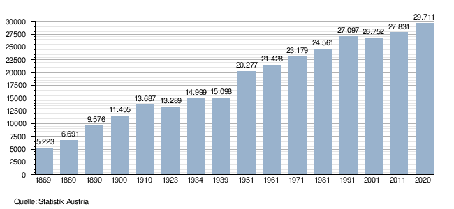
Population
Population development
Population structure
The age structure of the population in Bregenz differed slightly from the average in Vorarlberg in 2011. While 15.7 % of the population in Bregenz was under 15 years of age, the figure for the province was 16.6 %. The proportion of the population over 65 was 17.1%, which was higher than the Vorarlberg average of 15.7%. With regard to the employment rate of the 15-64 year olds, Bregenz with a value of 65.0% was clearly below the Vorarlberg value of 70.9%. The unemployment rate of 8.1%, on the other hand, was significantly higher than the Vorarlberg average of 5.0%. In 2011, 47.9 % men and 52.1 % women lived in Bregenz.
Educational background
In 2011, 50.7% of Bregenz residents had a secondary degree (AHS, BMS, BHS or apprenticeship) and 12.7% had a tertiary degree (university, academy or college degree) as their highest completed education, which is higher than the Vorarlberg average of 9.4%.
Related articles
Author
AlegsaOnline.com Bregenz: Austrian lakeside capital of Vorarlberg Leandro Alegsa
URL: https://en.alegsaonline.com/art/13893