
Brava, Cape Verde
Smallest inhabited island of Cape Verde, volcanic and agricultural, noted for steep coasts, strong diaspora links, morna music and the poet Eugénio Tavares; limited tourism and mainly reached by sea.
Overview

Brava, often called Ilha Brava, is the smallest inhabited island of the Cape Verde archipelago. Located on the southwestern edge of the island chain, it forms a compact, mountainous landmass of volcanic origin. Compared with many other Cape Verde islands it receives relatively more moisture and supports denser vegetation on its slopes, which has allowed a long tradition of small-scale agriculture. Its rugged coastline and steep cliffs have made sea access the main link with the outside world and delayed extensive development.
Image gallery
9 Images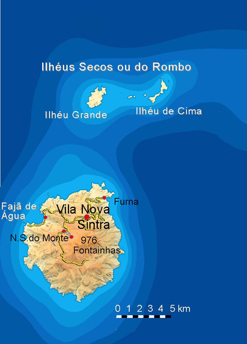


Geography and natural features
Brava rises from the Atlantic as a volcanic island and shares a geological base with neighbouring Fogo. The interior is dominated by steep ridges and deep valleys; summits and crater remnants form much of the terrain. Terraced fields and wooded ravines appear where rainfall accumulates, producing conditions more favourable to farming than on drier islands. Freshwater is limited and historically collected in cisterns and springs. The shore is largely rocky with few natural harbours, so many settlements are perched above the sea on more sheltered slopes.
History and settlement
Because of its precipitous coasts Brava was settled later than some larger islands. Permanent habitation increased from the late 17th and 18th centuries when sailors, fishermen and farmers established communities on the more accessible terraces and valleys. The island served as a coaling and provisioning stop and, during the 19th and early 20th centuries, played a role in transatlantic whaling operations; its seamen and shipworkers often joined long-distance voyages. These maritime connections contributed to patterns of emigration, particularly to New England in the United States, where many islanders found work and established communities.
Culture, language and music
Brava developed its own local variety of Cape Verdean Creole within the Sotavento (leeward) group of dialects. The island has a notable cultural reputation through its contribution to Cape Verdean literature and song. Brava is associated with the mornas—melancholic songs of longing, farewell and memory—which reflect the experience of migration and separation. The poet and lyricist Eugénio Tavares, born on Brava, became a key figure in codifying morna themes and rhythms and remains an important cultural reference for the country.
Economy, transport and contemporary life
Economic activity on Brava is largely local and diversified between subsistence agriculture, small-scale commerce and remittances from a large diaspora. Historically, seafaring and whaling provided employment; today many households depend on money sent by relatives abroad. Tourism exists but is limited compared with other Cape Verde islands because of the island's isolation and modest infrastructure. Regular connections are primarily by sea, with ferries linking Brava to neighbouring islands; air access has been intermittent and subject to operational constraints.
Notable facts and distinctions
- Brava is the smallest of Cape Verde's inhabited islands and one of the most densely settled in its compact area.
- The island's cultural legacy—especially morna poetry and song—has had an outsized influence on national identity.
- Strong diaspora ties, particularly with New England, continue to shape Brava's economy and social networks.
- Its steep, rocky coastlines limit mass tourism, preserving traditional village life and landscapes.
Today Brava is valued for its scenic terraces, cultural heritage and resilient communities. Visitors who reach the island encounter a quiet, mountainous environment where music and memory remain tightly woven into everyday life.
Geography
Brava is almost circular with a diameter of up to 11 kilometres and an area of 67 square kilometres. The medium mountainous island is the westernmost of the Ilhas de Sotavento (engl. 'Islands under the Wind') and lies to the west of the island of Fogo. Brava's altitude is barely sufficient to receive precipitation from the trade wind clouds. However, because it lies in the lee of Fogo's volcanic cone, the island is often covered by lee clouds, so evaporation is less and vegetation is somewhat richer. The Cape Verdean man of letters João Rodrigues characterized Brava as "bathed in green and filled with flowers" and in this comparable to Madeira in contrast to many of the more barren islands of the archipelago. The conditions for agriculture are therefore, together with those of Fogo, better than on the other islands of the Sotavento.
The island rises with steep cliffs to a wide plateau, deeply cut by erosion valleys.
The island is more densely populated at the higher altitudes. Here you will also find the island's capital Vila Nova Sintra and the pilgrimage site Nossa Senhora do Monte. On the east coast, the only permanent port on the island is in Furna. Vinagre is the source of an acetic mineral spring that used to be used for spa purposes.
About six kilometres north of the island lie the uninhabited Ilhéus do Rombo, 20 kilometres southwest the submarine Cadamosto seamount closes the archipelago to the west.

Geology
Originally a deep sea mountain of volcanic origin, the island was raised above sea level over time. Today, unlike on Fogo, there is no significant volcanic activity on the island anymore, but much stronger seismic activity than on Fogo. The geological evolution of Brava can be divided into three volcanostratigraphic units (from young to old):
- Upper unit
- Middle unit
- Lower unit
The Lower Unit consists of a submarine volcanic succession of Pliocene age (Piacenzian to Gelasian) formed 3 to 2 million years BP. During this time, Brava was in the seamount stage; this part consists of hyaloclastites and pillow lavas interbedded with innumerable cogenetic vein cohorts. Geochemically, these are ankaramites and nephelinites. The Lower Unit was intruded in the Old Pleistocene (1.8 to 1.3 million years BP) by a plutonic alkali rock/carbonatite complex of the Middle Unit, consisting of pyroxenites, ijoliths, nepheline syenites and carbonatites (soevites). Between 1.3 and 0.25 million years BP, these two units were subject to severe erosion; an erosional unconformity formed with the succeeding Upper Unit. In the upper Middle Pleistocene, 250,000 years ago, volcanism resumed after a long dormant period, yielding mainly phonolitic rocks. It is characterized by explosive, phreatomagmatic and magmatic ejecta. Pyroclastic flows (block and ash flows), pyroclastic blankets with surge phenomena and numerous craters formed by phreatic eruptions. Effusive lava flows and lava domes were formed.
A special feature of Brava is the occurrence of intrusive as well as extrusive carbonatites. Intrusive carbonatites are found in the plutonic Middle Unit; they are younger than comparable deposits on the neighbouring islands of Fogo, Santiago and Maio. Extrusively, young Pleistocene to Holocene carbonatites are found in the Upper Unit and are unique to Cape Verde.
The island is thought to have been uplifted from the sea since the seamount stage because of submarine deposited hyaloclastites and pillow lavas and uplifted beaches up to 400 metres above sea level. Estimates give an uplift rate of 0.2 to 0.4 millimetres/year.
Brava is traversed by many faults, lateral thrusts and volcanic/tectonic lineaments that have been instrumental in shaping the evolution of the island. The intrusive veins of the lower unit are orthogonally organized with a predominant east-west orientation. Faults in the two upper units follow predominantly north-northwest to northwest directions.
The spatial arrangement of the faults corresponds more or less to the stress field encountered on the neighbouring island of Fogo. Both islands as well as the Cadamosto seamount and the Ilhéus do Rombo sit on the same substructure, which is supported by 500 to 1000 metres of thick marine sediments at a depth of about 4000 metres. The sediments, in turn, overlie oceanic crust from the Lower Cretaceous, which begins at a depth of about 5300 meters and extends to a depth of 13 kilometers.
Questions and answers
Q: Where is Brava located?
A: Brava is an island located in Cape Verde.
Q: Which group in Cape Verde does Brava belong to?
A: Brava belongs to the Sotavento group in Cape Verde.
Q: Is Brava a large island in Cape Verde?
A: No, Brava is the smallest inhabited island in the Cape Verde archipelago.
Q: What was the main industry of Brava in the past?
A: The main industry of Brava in the past was whaling.
Q: What is the primary industry of Brava now?
A: Now, the primary industry of Brava is agriculture.
Q: How long did Brava's main industry last?
A: Brava's main industry of whaling lasted for more than a century.
Q: Is Brava uninhabited?
A: No, Brava is the smallest inhabited island in the Cape Verde archipelago.
Tags
Related articles
Author
AlegsaOnline.com Brava, Cape Verde Leandro Alegsa
URL: https://en.alegsaonline.com/art/13781
Sources
- hdl.handle.net : Valor simbólico do centro histórico da Praia
- whc.unesco.org : Centre historique de Nova Sintra
- ine.cv : Cabo Verde, Statistical Yearbook 2015