
William 'Strata' Smith: creator of the first geological map
William 'Strata' Smith (1769–1839) was an English surveyor and geologist whose work established the principle of faunal succession and produced the first nationwide geological map of Britain.
William 'Strata' Smith (23 March 1769 – 28 August 1839) was an English geologist and surveyor best known for producing the first large-scale, nationwide geological map. Travelling widely while working on engineering and drainage projects, he noticed consistent patterns in layers of sedimentary rock and their contained fossils, a discovery that became foundational to modern stratigraphy.
Image gallery
10 Images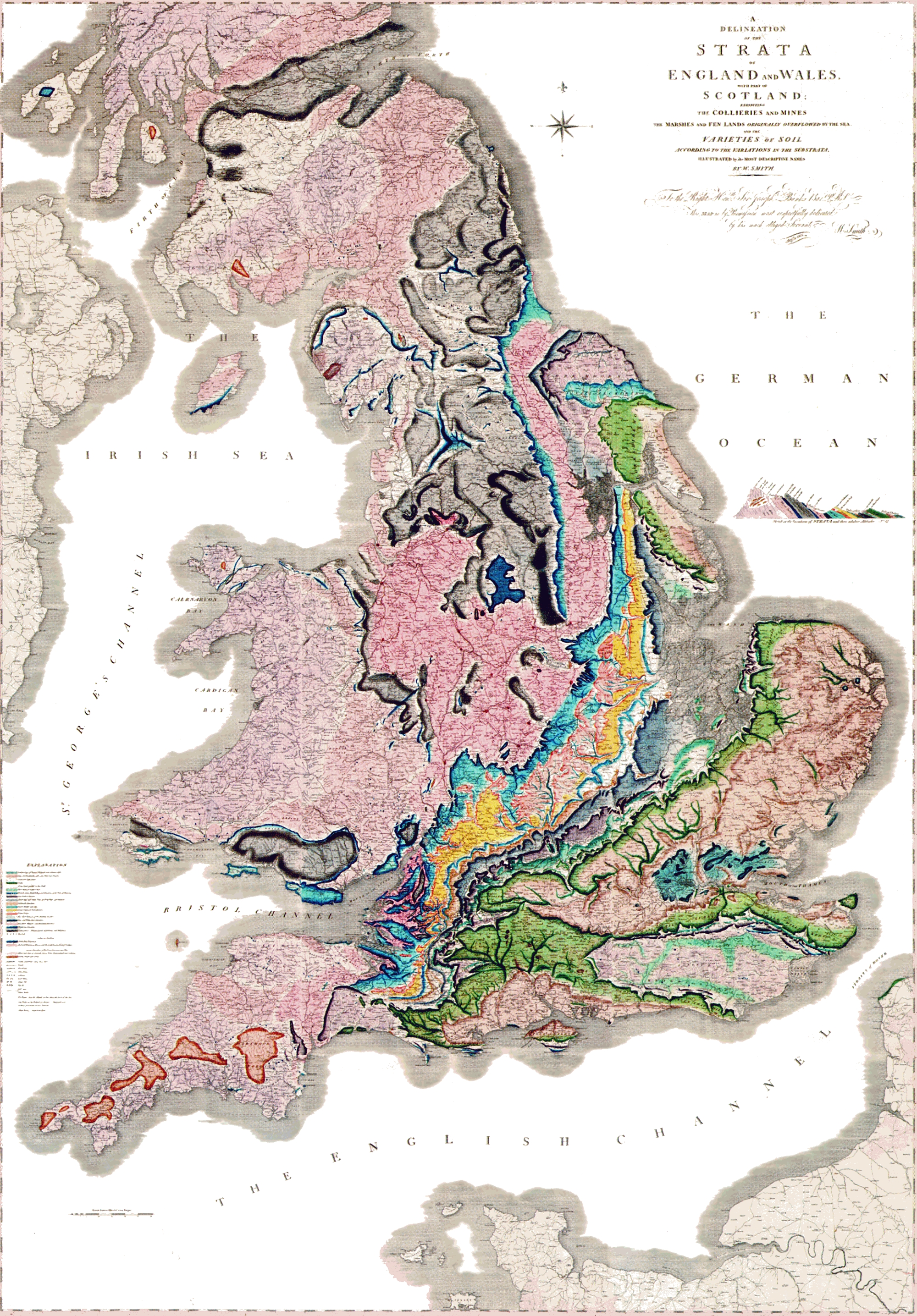




Background and early life
Smith was born into a modest family; like Michael Faraday, he was the son of a blacksmith. He had limited formal schooling but learned surveying and field observation while working on canals, mines and civil projects. Those practical occupations required mapping the land and exposed many rock outcrops, giving him the opportunity to compare strata across different districts.
Scientific contributions
While conducting surveys across England, Wales and southern Scotland, Smith recognized that particular sequences of sedimentary layers often contained a distinctive assemblage of fossils. From these patterns he inferred that rocks of the same relative age could be identified by their fossil content even when they were separated geographically. This observation—later called the principle of faunal succession—allowed Smith to correlate strata over long distances and to arrange rock units into a coherent relative geological history.
Map, method and examples
- Smith produced hand-colored maps and cross-sections that showed the distribution of rock types across large areas and their relative order.
- He used fossils as markers to correlate layers; for example, particular shelly fossils and plant remains helped distinguish one sequence from another.
- His maps made geological information accessible to engineers, miners, farmers and other practical users as well as to naturalists.
Career difficulties and later recognition
Despite the practical importance of his work, Smith struggled socially and financially. Poor access to elite scientific circles, and the fact that his ideas were copied by others, left him vulnerable to plagiarism and economic hardship. He endured serious financial reverses and even imprisonment for debt. In later years, however, the significance of his methods and his map became widely acknowledged, and he received recognition from the broader scientific community before his death.
Legacy and importance
Smith's approach transformed geology from a collection of local observations into a discipline capable of constructing regional and national geological histories. His use of fossils for correlation remains a basic tool in stratigraphy and paleontology. Modern geological mapping and many practical applications in resource exploration, engineering and land-use planning trace their origins to Smith's field-based methods and his conviction that rocks could be read as pages of Earth's history. For further reading and resources see the contemporary summaries and collections of his work: biographical summaries, his original map descriptions at map repositories, and contextual material about his era at scientific biographies and regional histories of England, Wales and southern Scotland.
Questions and answers
Q: Who was William 'Strata' Smith?
A: William 'Strata' Smith was an English geologist who created the first nationwide geological map.
Q: What was Smith's background?
A: Smith was the son of a blacksmith which meant that his family was humble.
Q: How did Smith make his geological discoveries?
A: Smith made his geological discoveries when he was a young man and worked as a surveyor, traveling the country.
Q: What was Smith's greatest discovery?
A: Smith's greatest discovery was that sedimentary rocks of a similar age held fossils of a similar type, allowing him to identify them when they were at the surface in different parts of the country.
Q: What did Smith do with his discoveries?
A: Smith put together the historical geology of Britain (England and Wales) and southern Scotland into a single record.
Q: How was Smith treated by the scientific community when his map was first published?
A: At the time Smith's map was published, he was almost unknown to the scientific community.
Q: Why did Smith face financial troubles later in his life?
A: Smith's work was plagiarised, leading him to financial ruin and even time in debtors' prison.
Author
AlegsaOnline.com William 'Strata' Smith: creator of the first geological map Leandro Alegsa
URL: https://en.alegsaonline.com/art/132990