Bosnia and Herzegovina
![]()
This article is about the present-day state. For other meanings, see Bosnia and Herzegovina (disambiguation).
Template:Infobox State/Maintenance/NAME-German
Bosnia and Herzegovina (Bosnian/Croatian/Serbian-Latin Bosna i Hercegovina [ˌbɔsnaixɛrʦeˈɡoːvina], Serbian Cyrillic Босна и Херцеговина, abbreviations: BiH/БиХ; also called Bosnia and Herzegovina or, incorrectly shortened, Bosnia) is a southeastern European federal state. It consists geographically of the region of Bosnia in the north, which occupies about 80 percent of the state's territory, and the smaller region of Herzegovina in the south. Political sub-regions of the federal state are the Republika Srpska, the Federation of Bosnia and Herzegovina, and the Brčko District as a special administrative region.
The country lies east of the Adriatic Sea on the Balkan Peninsula and is almost entirely located in the Dinaric Mountains. Neighbouring countries are Croatia to the north and west, Serbia to the east, and Montenegro to the southeast. The population of Bosnia and Herzegovina was just over 3.5 million in 2013 (see Bosnians and Herzegovinians). The capital and largest city of the country is Sarajevo, other major cities are Banja Luka, Tuzla, Zenica, Bijeljina and Mostar.
Overview
The state emerged in its present form from the Dayton Agreement (1995) and is, according to this, the legal successor to the Republic of Bosnia and Herzegovina, which was founded immediately after a referendum in early 1992 and was the only internationally recognised of a total of four state entities on the territory of Bosnia and Herzegovina during the Bosnian War. The Treaty of Dayton ended the war in the country and created a unified but highly decentralized (federal) state. Today, Bosnia and Herzegovina consists of two entities, the Federation of Bosnia and Herzegovina (populated by a majority of Bosniaks and Bosnian Croats) and Republika Srpska (populated by a majority of Bosnian Serbs). The Special Administrative Region of Brčko was subsequently created from parts of the pre-war Greater Brčko Municipality belonging to both entities and today functions as a condominium of both entities, but administers itself independently.
Bosnia and Herzegovina is bordered by three countries. Serbia to the east, Montenegro to the southeast, and Croatia to the north, west and southwest. Furthermore, the state has a 20-kilometer-long coastal strip on the Adriatic Sea near Neum in the Neum Corridor.
Bosnia and Herzegovina is a member of the Central European Free Trade Agreement, the United Nations, the Organization of Islamic Cooperation (observer status), the Council of Europe, a participant in the Organization for Security and Cooperation in Europe, and the Cooperation Council for Southeast Europe. Furthermore, the country has been an official candidate for NATO membership since 2010 and a potential candidate for membership of the European Union.
Geography
Bosnia and Herzegovina is located in the western part of the Balkan Peninsula and is characterized in large parts by a forested low mountain range, with the highest mountains reaching heights of almost 2400 meters above sea level. Part of the mountainous area, especially in the western parts of the country and Herzegovina, is karstified. The surface water that accumulates here does not reach the large river systems, but seeps away for the most part. In the south, as well as in the Sava lowlands to the north, there are also flatter regions that are used for agriculture. Also in the south is the 20-kilometre-long Adriatic coast near Neum.
See also: List of the highest mountains in Bosnia and Herzegovina
Borders
Bosnia and Herzegovina has a total of 1538 kilometres of external border with its three neighbouring states. Of these
- 932 kilometres to Croatia, which surrounds the country in an arc to the north and west; this border is part of the EU's external border,
- 357 kilometres to Serbia in the east and
- 249 kilometers to Montenegro in the southeast.
The only access to the sea is the Neum Corridor, a strip of land that interrupts the Croatian territory over a width of about 7.5 kilometres. The southern part of Croatia with the city of Dubrovnik can so far only be reached by land via the territory of Bosnia-Herzegovina or from the east from Montenegro. From 2022, the Pelješac Bridge will create a road connection between the two parts of Croatia, bypassing the Neum Corridor.
Due to its central location, Bosnia and Herzegovina is the only former Yugoslav republic surrounded exclusively by other former republics.
Geomorphology
The highest areas of the country are located in the southeast, on the historical border between Bosnia and Herzegovina. The peak of the Maglić massif, located south of Foča on the Montenegrin border, is the highest point at 2386 metres. The rest of the country is mainly characterized by low mountainous landscape.
Climate
Bosnia and Herzegovina is located in the transition area between Mediterranean and continental climate. Winters can be very cold and temperatures down to -20 degrees Celsius are not uncommon. Summers are mainly very hot and dry due to the location of the country.
Landscape zones
The country can be divided into three landscape zones according to the climatic zones.
The Pannonian Plain
On its northern border, Bosnia and Herzegovina is part of the Pannonian Plain, which extends here in the area of the Sava lowlands.
The Dinaric mountain region
The Dinaric mountain region, also called the "Bosnian Dinarides", stretches from the southeast of the country across the central region to the northwest. This landscape is characterized by numerous mountains, which are less karstified, but covered with forest surfaces. Cities such as Sarajevo, Zenica and Bihać, among others, are located in this landscape zone. These areas are usually very warm in summer, with temperatures of up to 35 °C, and cold in winter, when the temperature can also drop to -15 °C and a lot of snow can fall.
The Adriatic coastal region
Herzegovina is mostly part of the Adriatic coastal region. Characterized by Mediterranean influences, Herzegovina consists mainly of karst or karstified mountain ranges. The Neretva River, which flows from northeastern Herzegovina through Mostar towards the Adriatic coast, is the largest and best known of this region.
Waters
The country's main rivers are the Sava and Drina, which border Bosnia and Herzegovina to the north and east, and the Bosna, which rises in the interior and flows into the Sava. Almost the entire territory of Bosnia belongs to the Sava or Black Sea catchment area, while the rivers of Herzegovina drain - partly underground - into the Adriatic Sea.
The valleys of Bosnia's major rivers extend almost exclusively in a north-south direction, which is significant for the country's settlement and transport history. The larger rivers include the Una and Sana, the Vrbas and the Neretva. Apart from the Sava River on the border with Croatia, no river in Bosnia and Herzegovina is navigable.
Bosnia and Herzegovina is located in the Blue Heart of Europe.
Bosnia and Herzegovina has few significant lakes. Most of the large still waters have been artificially dammed. Large reservoirs exist on Drina (e.g. Lake Zvornik), Neretva (Jablaničko jezero), Vrbas and Trebišnjica (Bilećko jezero). Modračko jezero near Lukavac in the canton of Tuzla is also a reservoir.
See also: List of rivers in Bosnia and Herzegovina
Land use
Only just under one fifth of the country's area is suitable for arable farming. This land is mainly located along the Sava River, on the lower reaches of the Neretva River and in the Poljen of Herzegovina.

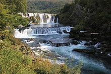
Waterfall Štrbački Buk on the Una near Bihać

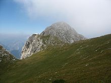
The highest point of the country: Maglić.

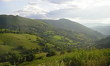
Landscape in the southwestern part of Bosnia (near Donji Vakuf)
Questions and Answers
Q: What is Bosnia and Herzegovina?
A: Bosnia and Herzegovina is a country in Southeastern Europe with an area of 51,197 km2 and a population of 4,600,000 people.
Q: What are the neighboring countries of Bosnia and Herzegovina?
A: The neighboring countries of Bosnia and Herzegovina are Croatia, Serbia, and Montenegro.
Q: What is the capital city of Bosnia and Herzegovina?
A: The capital city of Bosnia and Herzegovina is Sarajevo.
Q: Name some important cities of Bosnia and Herzegovina?
A: Some important cities of Bosnia and Herzegovina are Banja Luka, Mostar, Zenica, and Tuzla.
Q: What is the majority religion and major branch in Bosnia and Herzegovina?
A: The majority religion in Bosnia and Herzegovina is Islam, and the major branch is Sunni.
Q: What is the abbreviation of Bosnia and Herzegovina?
A: The most commonly abbreviated form of Bosnia and Herzegovina is BiH/БиХ.
Q: What is the population of Bosnia and Herzegovina?
A: The population of Bosnia and Herzegovina is 4,600,000 people.
Search within the encyclopedia