Bonn — German city on the Rhine
Bonn is a city on the Rhine in western Germany, known as the birthplace of Beethoven, a former capital of West Germany and a contemporary centre for culture, education and international institutions.
Overview
Bonn is a city in western Germany situated on the banks of the Rhine River. It lies immediately south of Cologne and is part of the densely populated Rhine-Ruhr area. Administratively the city belongs to the state of North Rhine-Westphalia, one of Germany's federal states; it is also sometimes described in relation to the regional authorities and government bodies of the state. The urban area combines historical quarters with modern government offices, universities and cultural institutions. The city's population is roughly in the mid-hundred-thousands, making it a medium-sized German city with international connections.
Image gallery
10 Images


Geography and character
Bonn's position on the Rhine has shaped its development: river transport, trade and fertile surrounding land supported settlement since antiquity. The city center contains a mix of baroque and 19th-century architecture alongside postwar administrative buildings. Green spaces and parks are integrated with dense urban neighbourhoods, and Bonn forms one pole of a larger Cologne–Bonn metropolitan region that shares economic, transport and cultural links.
Historical development
The place where Bonn now stands was occupied in Roman times and grew from a Roman fort and settlement into a medieval market town. Over centuries it became the residence of regional rulers and developed institutions typical of central European towns: churches, guilds and a market economy. In the 19th and early 20th centuries Bonn expanded with industrialization and improved communications, while preserving older civic monuments.
Role as capital and political significance
After the Second World War Bonn acquired exceptional political importance. In 1949 it was chosen as the provisional capital of West Germany and became the seat of the federal government. The first chancellor of the new West German state was Konrad Adenauer, a prominent local politician originally from the Cologne area who favoured Bonn as the governmental centre; the decision reflected both practical and symbolic considerations, including a desire for a fresh start after the war and a more modest seat for a divided Germany. The city earned the ironic nickname Bundesdorf ("federal village") because its scale was small compared with typical national capitals. After German reunification the national parliament voted to move many central institutions to Berlin; the transfer of the main government functions was completed in the late 1990s, though Bonn retained several federal offices and ministries by law and agreement.
Culture, education and modern role
Bonn is notable for cultural and academic institutions. It is the birthplace of composer Ludwig van Beethoven and maintains museums and a preserved birthplace as part of its cultural attractions. The city hosts a major university and research institutions, and since the capital moved to Berlin Bonn has developed as an international centre for United Nations agencies and non-governmental organisations, housing several UN offices and climate-related secretariats. This gives Bonn an international profile well beyond its size.
Places of interest and notable facts
- Beethoven-related sites and music festivals that celebrate the city's musical heritage.
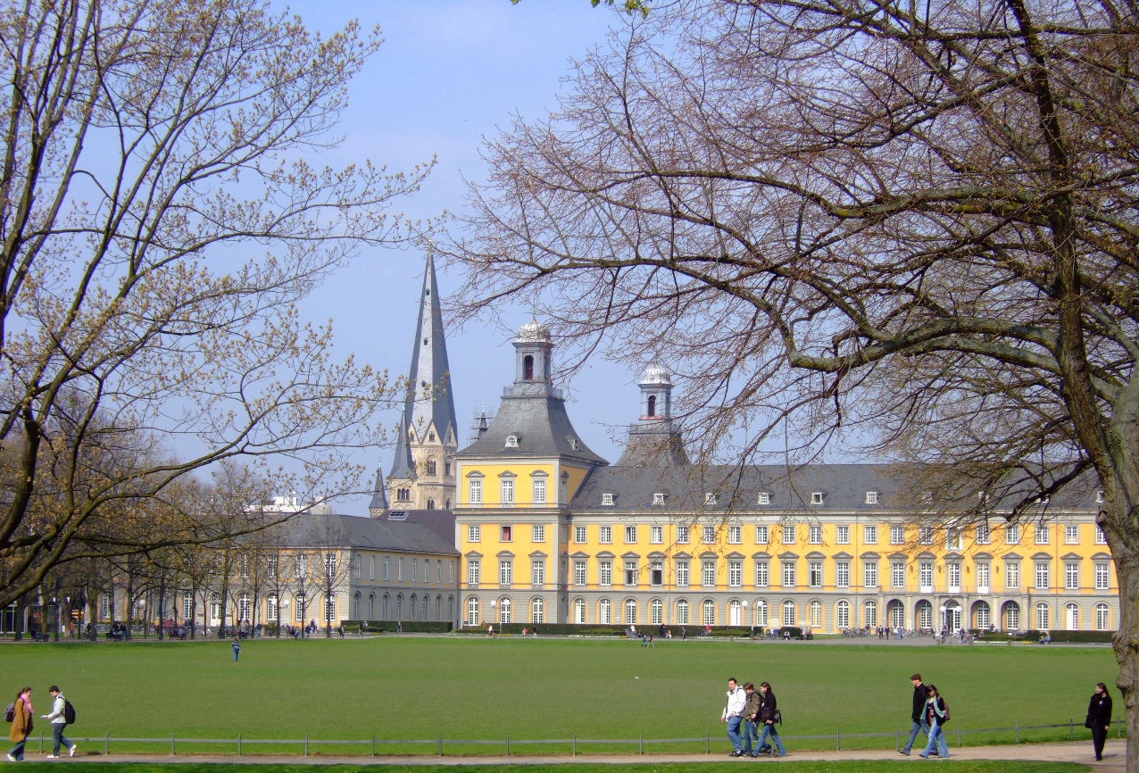
- The Kurfürstliches Schloss (Electoral Palace) and other historic buildings in the old town.
- A concentration of federal institutions retained after reunification under the provisions of the Berlin/Bonn arrangements; these continue to shape Bonn's economy and employment.
- A regional transport hub linking the city to Cologne and the wider Rhine corridor.
For readers seeking further administrative or historical detail, Bonn's municipal and regional pages provide official information as well as cultural guides: see the city administration entry at Bonn city resources and regional overviews at local portals and neighboring-city guides. Additional background on the city's role in postwar Germany and its transition after reunification can be explored through specialist histories and curated archives held by local museums and libraries.


Geography
Topography and landscape areas
enlarge and show information about the picture
![]()
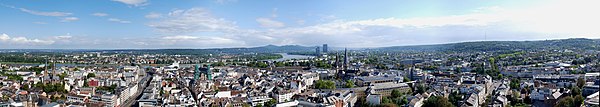
View from the Stadthaus to Bonn city centre and adjacent, formerly independent city districts, in the background the Siebengebirge mountains
The city of Bonn is located in the southwest of the state of North Rhine-Westphalia at the transition from the Middle Rhine region to the Lower Rhine Bay, which is marked by the Godesberg Rhine Valley Funnel. It extends over 141.1 square kilometres on both sides of the Rhine. The districts on the left bank of the Rhine make up about three quarters of the total area.
In the south and west, the foothills of the Eifel with the Kottenforst, which belongs to the Rhineland Nature Park, and the Voreifel enclose the city. North of Bonn, the Rhine valley opens up into the Cologne Bay, which is accompanied by the Ville foothills from the Duisdorf district onwards. The Sieg River, which flows into the city here, represents the natural border in the northeast, the Siebengebirge Mountains in the southeast, while in the east there are still some districts on the right bank of the Rhine in the Pleiser Hügelland. Beyond the Siebengebirge, the Westerwald extends to the southeast of Bonn, and beyond the Siegniederung to the northeast, the Bergisches Land.
Bonn has its geographical center at the Bundeskanzlerplatz, which is located in the district of Gronau. The geographical position of the square is 50° 43′ 8,8″ N, 7° 7′ 3,3″ E50.71911388897.117572222.The city center of Bonn, which does not face the Rhine, lies at an altitude of 56 m to 61 m above sea level.
The largest extension of the city area in the north-south direction is 15 kilometers, in the west-east direction 12.5 kilometers. The city limits have a length of 61 kilometers.
On the right side of the Rhine lies the Ennert, the northern foothills of the Siebengebirge, on the Bonn city area. It includes the Paffelsberg, which at 195.3 m above sea level is the highest elevation in the city of Bonn. Further elevations in this mountain range are the Ennert, which gives it its name, Holtorfer Hardt and Röckesberg as well as Rabenlay and Kuckstein, each with striking steep slopes, and Finkenberg to the west. On the left side of the river the dominating elevations are Venusberg (171 m) and Kreuzberg (158 m), to the southwest the urban area rises to the Kottenforst to up to 190 m. The lowest point of the town is located on the left side of the river. The lowest ground level is 45.6 m above sea level on the Kemper Werth headland at the mouth of the Sieg.
Neighboring communities
Ten towns and communities border on the Bonn district, all of which - with the exception of Remagen, which lies in the Ahrweiler district in the state of Rhineland-Palatinate - belong to the Rhine-Sieg district in North Rhine-Westphalia:
| Bornheim | Niederkassel, | |
| Alfter |
| Königswinter |
| Meckenheim | Wachtberg | Bad Honnef, |

enlarge and show information about the picture
![]()
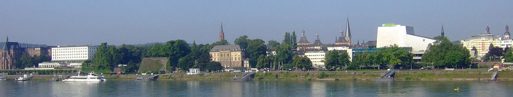
View from Beuel to Bonn-Centre
City division and classification
Bonn is an independent city with the license plate BN.
According to § 3 of the main statutes, Bonn is divided into four city districts, which consist of a total of 51 districts. Each city district has its own district representation with a district mayor. In addition, the city consists of 65 statistical districts, some of which are similar to the local districts in name and size. In addition, Bonn is divided into nine districts by the municipal statistics office: Bonn Central Area, Bonn-Southwest, Bonn-Northwest, Federal Quarter, Godesberg Central Area, Godesberg Outer Ring, Beuel Central Area, Beuel Outer Ring and Hardtberg.
On the territory of the city of Bonn there are 21 parishes in the borders of former municipalities.
| City structure of the Federal City of Bonn | |||
| Borough | Coat of arms | Inhabitants (as of 2020) | Local parts |
|
| 75.655 | Alt-Godesberg, Friesdorf, Godesberg-North, Godesberg-Villenviertel, Heiderhof, Hochkreuz, Lannesdorf, Mehlem, Muffendorf, Pennenfeld, Plittersdorf, Rüngsdorf, Schweinheim | |
| Beuel |
| 67.825 | Beuel-Mitte, Beuel-Ost, Geislar, Hoholz, Holtorf, Holzlar, Küdinghoven, Limperich, Oberkassel, Pützchen/Bechlinghoven, Ramersdorf, Schwarzrheindorf/Vilich-Rheindorf, Vilich, Vilich-Müldorf |
| Bonn |
| 155.235 | Auerberg, Bonn-Castell (until 2003: Bonn-Nord), Bonn-Zentrum, Buschdorf, Dottendorf, Dransdorf, Endenich, Graurheindorf, Gronau, Ippendorf, Kessenich, Lessenich/Meßdorf, Nordstadt, Poppelsdorf, Röttgen, Südstadt, Tannenbusch, Ückesdorf, Venusberg, Weststadt |
| Hardtberg |
| 34.576 | Brüser Berg, Duisdorf, Hardthöhe, Lengsdorf |
Bonn belongs to the administrative district of Cologne. The district government, which is based in Cologne, is the central authority of the state and supervises the municipal budget of the city of Bonn, among other things. Furthermore, the district government supervises the schools in Bonn.
Furthermore, Bonn belongs to the Landschaftsverband Rheinland (LVR), which is also based in Cologne. As part of the municipal self-administration, the LVR performs tasks for Bonn in the area of social institutions, e.g. the sponsorship of specialist hospitals and in particular psychiatric hospitals or special schools for disabled children. Furthermore, the LVR is responsible for the preservation of historical monuments in Bonn.
Settlement geography and spatial planning
Bonn forms the southern edge of the Rhine-Ruhr metropolitan region, which is understood as a polycentric conurbation in North Rhine-Westphalia and extends along the rivers Rhine and Ruhr that give it its name. The Rhine-Ruhr metropolitan region covers an area of approximately 7,000 km² with more than ten million inhabitants, is one of the five largest metropolitan regions in Europe and is the most populous of the eleven metropolitan regions in Germany. It is also located in the middle of the central European economic area, the so-called Blue Banana. The Bonn conurbation includes parts of the cities of Sankt Augustin and Königswinter on the right bank of the Rhine.
Climate
| Bonn | ||||||||||||||||||||||||||||||||||||||||||||||||
| Climate diagram | ||||||||||||||||||||||||||||||||||||||||||||||||
| ||||||||||||||||||||||||||||||||||||||||||||||||
| Monthly average temperatures and precipitation for Bonn
Source: Weather Service, Data: 2015-2020 DWD, data: Jan 1981 - Dec 2010 WeatherKontor, data: Records | ||||||||||||||||||||||||||||||||||||||||||||||||||||||||||||||||||||||||||||||||||||||||||||||||||||||||||||||||||||||||||||||||||||||||||||||||||||||||||||||||||||||||||||||||||||||||||||||||||||||||||||||||||||||||||||||
From a large-scale perspective, Bonn belongs to the Atlantic-Maritime climate range, i.e. the climate is mild and generally warm and temperate. "Cfb" is the Köppen-Geiger classification.
This means winters with little snow, with an average of 56 frost days (lowest temperature below 0 degrees Celsius) and only ten ice days (daily maximum temperature below 0 degrees), with an average January temperature of 2.0 degrees. The average temperature in July is 17.6 degrees Celsius, the average annual temperature is 10.0 degrees. Thus Bonn is one of the warmest regions in Germany. Accordingly, the flowering season starts early in spring.
In terms of precipitation, Bonn lies in the rain shadow of the adjacent low mountain range landscape to the south. While the city has an average annual precipitation of only 742 millimetres, the annual precipitation in the Eifel is over 800 millimetres.
The constantly high relative humidity has a stressful effect on people. With an average of 35 muggy days, Bonn is far ahead of other German cities. In the vernacular, this is referred to as Bonn's "irritable climate". Bonn residents know that this effect can be felt most strongly in the city's lowest location, in a former arm of the Rhine, in the area around the main railway station.
Among other things, the insufficient air movement in the basin is responsible for the excessive sultriness, as the fresh air coming mostly from the west is slowed down by the northern foothills of the Eifel mountains. The valley basin results from the topography: the Lower Middle Rhine Valley ends in Bonn, which here merges into the Cologne Bay. The low air movement in turn influences the inner-city warming, so that the temperatures within the city area in July, for example, are on average 3 to 5 degrees Celsius higher than in the surrounding area.
In the winter months and during the snow melt, the Rhine often overflows its banks. During floods, especially streets and houses in the districts Mehlem (left bank of the Rhine) and Beuel (right bank of the Rhine) are endangered.
The regional climate with its peculiarities, low snow in winter and humid in summer, also makes for typically laconic Bonn sayings, such as the well-known: "Either it rains, or the barriers are down."


History
→ Main article: History of the city of Bonn
Chronology
In 1989 Bonn celebrated its 2000th birthday. The city thus commemorated the establishment of the first fortified Roman camp on the Rhine in 12 BC, after the Roman governor Agrippa had already settled Ubians on the site in 38 BC. However, people lived in the area of today's city much earlier. The 14,000 year old double grave of Oberkassel as well as a ditch and wooden palisades, which have been proven in the area of the Venusberg and date back to around 4080 BC, bear witness to this.
While the Roman presence in Bonna was still modest in the time before the birth of Christ, this was to change after the defeat of the Romans in the Varus Battle in 9 AD. In the following decades, a legion was stationed here and established a camp in the northern area of present-day Bonn. Around the camp and south of it along today's Adenauerallee, traders and craftsmen settled in a vicus.
The end of the Roman Empire was accompanied by the decline of Bonn in late antiquity and the early Middle Ages. During the Viking raids in the Rhineland, Bonn was twice burned down in 882, and in 883 the city, which had just been rebuilt, was attacked, burned and plundered once more by the Normans.
In Frankish times and finally in the 9th and 10th centuries, an ecclesiastical centre, the Villa Basilica, developed in the area of Bonn Cathedral and a market settlement in the area of today's market. 1243 is considered the year of the granting of full town rights.
The outcome of the Battle of Worringen in 1288 was of great importance for the further development of the city. The Cologne electors made Bonn - along with Brühl and Poppelsdorf - one of their residences and eventually their residence. The magnificent palaces built by the electors in the 17th and 18th centuries gave the city its baroque splendour.
With the occupation by French troops 8 October 1794 ended this era. This was followed by almost two decades of occupation by Napoleon's troops. The occupation duties of food, clothing and shelter as well as the loss of the electoral land administration led to an impoverishment of the population and a decrease in the number of inhabitants by about 20%. The French brought a civil code (Code civil) and communal municipal constitutions to Bonn. While still under French occupation, medium-sized and larger industrial enterprises were established, especially in the textile industry. The French also pursued a consistent secularization: properties of the ecclesiastical electoral state, especially the electoral buildings, became state property. Areas on the right bank of the Rhine in present-day Bonn in Vilich came into the possession of the Prince of Nassau-Usingen: Oberkassel belonged to the Duchy of Berg, a French satellite state. By the Treaty of Lunéville of 9 February 1801, the Rhine also became the French eastern border at Bonn. Bonn became the seat of a sub-prefecture in the newly formed Rhine-Moselle Department.
After the defeats of the French army in Russia (1812) and at the Battle of Leipzig, the French evacuated Bonn in January 1814.
In the course of the decisions of the Congress of Vienna, Bonn fell to Prussia in 1815. In the following decades, the city was shaped by the university, which was newly founded by the Prussian government on October 18, 1818. The university was founded and named after King Frederick William III of Prussia. At the end of the 18th century there had been a university in Bonn, which was closed with the French occupation in 1794. The Prussian re-foundation did not follow on from the university from electoral times, but was part of a foundation programme that included the Friedrich Wilhelm University in Berlin and the Silesian Friedrich Wilhelm University in Breslau. The addition Rheinische to the name of the Bonn university was intended to identify it as a sister of the Berlin and Breslau universities. In fact, over the next 100 years it became the preferred place of study for the Hohenzollern princes. It was also called the "Princes' University" because the then Prussian Prince Friedrich Wilhelm, his son Prince Wilhelm, as well as his four sons studied there. Other sons of high noble families also preferred to study at that university in the 19th century. Before the foundation in Bonn, Cologne had been the rival for a university foundation. The decisive factor was probably that Bonn's "enlightened tradition" seemed more suitable for a confessional parity university than "holy Cologne". But there were also purely practical reasons in favour of Bonn: with the old Electoral Palace and the Poppelsdorf Palace, there were already suitable properties.
Professors, students, civil servants and officers came to Bonn from 1815 onwards. Among them were numerous Protestants from the Prussian provinces, which was a special feature in the "Catholic" Rhineland. The Prussians also made Bonn a garrison town. In the course of this, Bonn also became popular as a place of retirement for military personnel. Tourism also received a boost after the foundation of the German Reich in 1871 in the course of the "Rhine Romanticism" of those years.
After World War I, the city was occupied first by Canadians, then by the British, and finally by the French until 1926.
More than 1,000 citizens of Bonn, for the most part citizens of the Jewish faith, were murdered during the National Socialist era. About 8000 people had to leave their hometown, were arrested or imprisoned in concentration camps. When the Second World War ended for Bonn on 9 March 1945 with the invasion of American troops, the degree of destruction of the buildings was 30 percent. Of these, 70 percent were slightly to severely damaged and 30 percent were completely destroyed residential buildings. More than 4000 Bonn citizens had died in bombing raids. On 28 May 1945, British troops took over the city as the occupying power.
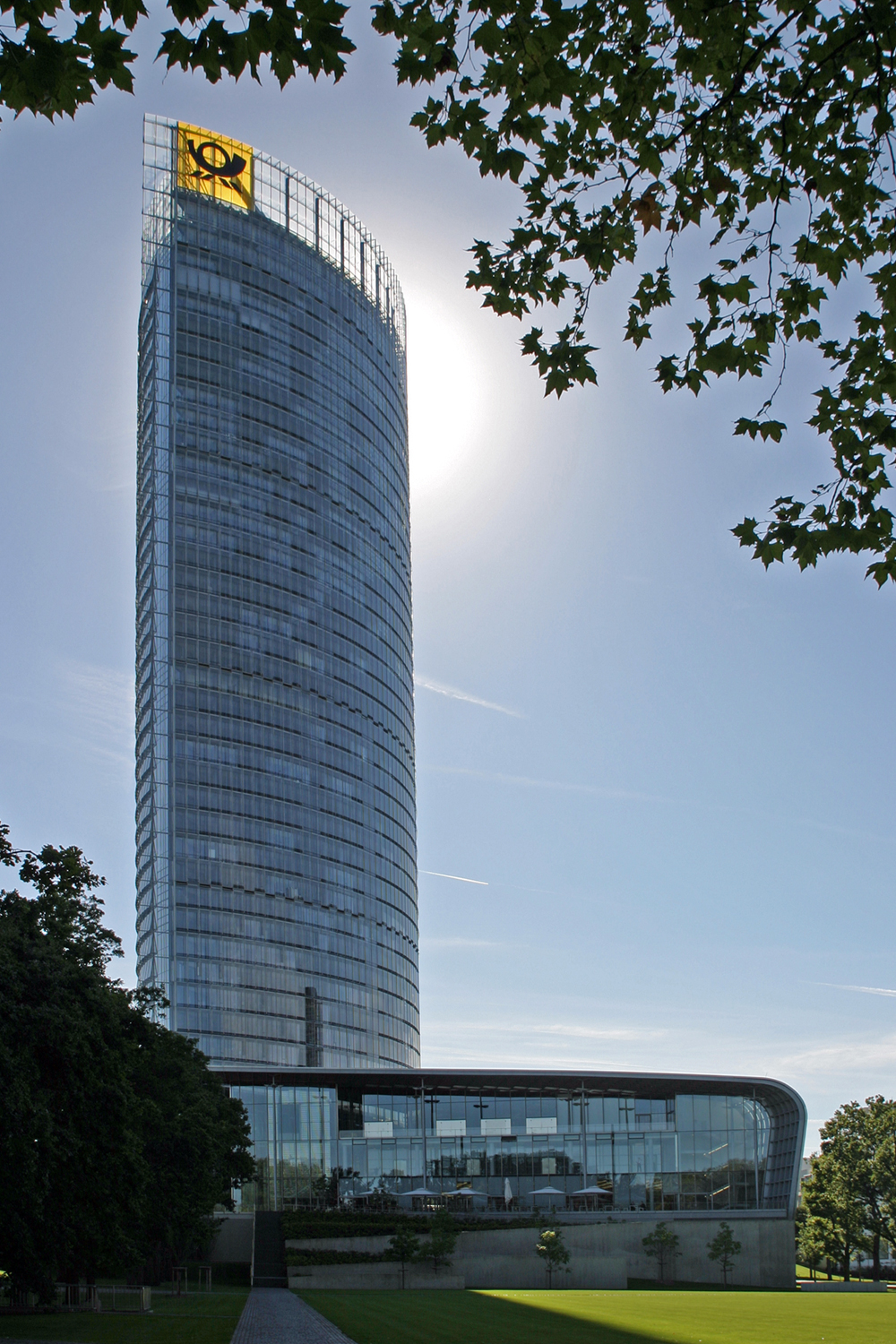
After World War II, the city experienced rapid development and expansion, especially after the decision in favour of Bonn as the provisional seat of government of the new Federal Republic of Germany instead of Frankfurt am Main on 29 November 1949 (see Capital city question of the Federal Republic of Germany). - As a result of the removal of parliament, parts of the government, a large proportion of the diplomatic missions and many lobbyists, and the privatisation of the Federal Post Office, which was brought about by the Act Implementing the Decision of the German Bundestag of 20 June 1991 on the Completion of the Unification of Germany (Berlin/Bonn Act), the city underwent another transformation at the turn of the millennium. The remaining ministries, federal authorities that moved in, administrative headquarters of large German companies, international organizations and institutions of science and science administration are the carriers of this structural change, which is considered successful so far and continues to this day.
Incorporations
The city of Bonn was enlarged several times by incorporations. Around 1900 Bonn had grown strongly. As a result, the towns of Poppelsdorf, Endenich, Kessenich and Dottendorf, with which Bonn had grown together structurally, were incorporated on 1 June 1904.
As a result of the territorial reform of August 1, 1969, which was accompanied by the law on the municipal reorganization of the Bonn area ("Bonn Law"), the population of the city was approximately doubled and the Siegkreis was merged with the Landkreis Bonn to form the Rhein-Sieg-Kreis. The once independent towns of Bad Godesberg and Beuel and the municipality of Duisdorf became separate boroughs of Bonn.
The municipality of Beuel, located on the right side of the Rhine, was additionally assigned the villages of Holzlar, Hoholz and the office of Oberkassel, which until then had belonged to the Siegkreis. Bonn itself was extended by the villages of Ippendorf, Röttgen, Ückesdorf, Lessenich/Meßdorf and Buschdorf of the former Bonn district, Lengsdorf and Duisdorf together with some new building areas formed the Hardtberg urban district.
The city of Bad Godesberg had previously incorporated several towns. Already in 1899 Plittersdorf and Rüngsdorf had become part of Godesberg, in 1904 Friesdorf was added, so that Bad Godesberg had in fact already grown together with Bonn. In 1915 Bad Godesberg had grown out of the valley to the southwest, so that Muffendorf was incorporated. On 1 July 1935, Lannesdorf and Mehlem became districts of Bad Godesberg.


Questions and answers
Q: What is Bonn?
A: Bonn is a city near Cologne in the German state of North Rhine-Westphalia.
Q: When was Bonn founded?
A: Bonn was founded on an old Roman settlement.
Q: How many people live in Bonn?
A: Approximately 327,000 people live in Bonn.
Q: Why did Konrad Adenauer choose Bonn as the provisional capital of West Germany?
A: Konrad Adenauer chose to use Bonn as the provisional capital of West Germany because it symbolised a new start for the new Germany and Frankfurt am Main had most of the needed facilities already, so using Bonn meant spending about 95 Million DM to building new roads and buildings.
Q: What nickname was given to Bonn due to its relatively small size for a capital city?
A: Due to its relatively small size for a capital city, Bonn was sometimes jokingly called the Bundesdorf (Federal Village).
Q: When did the Bundestag vote to move from Berlin from 1990 onwards?
A: The Bundestag voted to move from Berlin on 20 June 1991.
Q: When did government's move from Berlin to be completed?
A:The extra building work needed meant it was 1999 before the government's move was completed.
Tags
Related articles
Author
AlegsaOnline.com Bonn — German city on the Rhine Leandro Alegsa
URL: https://en.alegsaonline.com/art/12900