Ultras of the United States: definition, distribution, and significance
Overview of U.S. mountains whose topographic prominence is at least 1500 m (Ultras): definition, how prominence differs from elevation, distribution across states and territories, notable examples, and list resources.
The term Ultra is applied to any mountain whose topographic prominence equals or exceeds 1,500 metres (4,921 feet). Prominence measures how much a summit rises above its surroundings rather than its absolute elevation above sea level. Peaks meeting this threshold are often called "Ultras" or "P1500" and are valued both by geographers and by climbers seeking independent, dominant summits.
Image gallery
10 Images


What topographic prominence means
Prominence is calculated as the vertical distance between a summit and the lowest contour line encircling it and no higher summit. This lowest point is known as the key col. A high-prominence mountain stands clearly above nearby terrain and is usually visually and geographically distinct from neighboring peaks. Prominence emphasizes a mountain's individuality rather than just its height.
Distribution and the U.S. list
There are 128 mountains in the United States that qualify as Ultras. They are not evenly spread: Alaska contains the largest concentration, including many rugged ranges and long-distance cols, while the western contiguous states (Cascades, Sierra Nevada, Rockies) and the Hawaiian Islands also contribute several entries. Lists of these peaks are compiled and updated by mapping authorities, researchers, and peakbagging communities.
Notable examples and distinctions
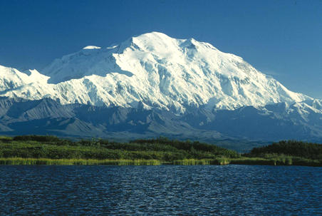
- Denali (Alaska) — a globally prominent summit and the highest peak in North America.
- Mauna Kea and Mauna Loa (Hawaii) — prominent both above sea level and when measured relative to surrounding ocean basins.
- Mount Rainier (Washington) — a major visual landmark with large local relief.
Prominence differs from elevation (absolute height above sea level) and from topographic isolation (distance to the nearest higher terrain). A mountain can be very high but have low prominence if it is a subsidiary summit of a higher neighbor.
Uses, measurement, and resources
Ultras are useful for scientific classification, conservation priorities, and mountaineering goals. Advances in digital elevation models, topographic mapping, and GPS surveying have refined prominence estimates and occasionally alter which summits qualify. For sortable catalogs, maps, and detailed tables of the 128 U.S. Ultras — including elevation, prominence, and coordinates — see curated peak lists and databases maintained by researchers and peakbagging organizations (Ultra listings and data portals).
Questions and answers
Q: What is an Ultra mountain?
A: An Ultra mountain is any mountain in the United States that has a topographic prominence of 1500 metres (4921 feet) or more.
Q: How many mountains in the United States qualify as Ultras?
A: There are 128 mountains in the United States that qualify as Ultras.
Q: What is the purpose of the list of Ultras of the United States?
A: The purpose of the list of Ultras of the United States is to provide a sort-able list of all the 128 mountains that qualify as Ultras.
Q: What is the definition of topographic prominence?
A: Topographic prominence is the height of a mountain or hill's summit relative to the lowest contour line encircling it but containing no higher summit within it.
Q: Are all mountains included in the list of Ultras of the United States?
A: No, only mountains with a topographic prominence of 1500 metres (4921 feet) or more are included in the list of Ultras of the United States.
Q: Can the list of Ultras of the United States be sorted?
A: Yes, the list of Ultras of the United States is sort-able.
Q: What is the significance of a mountain being classified as an Ultra?
A: The significance of a mountain being classified as an Ultra is that it indicates a particularly high level of topographic prominence and makes the mountain a particularly noteworthy peak for mountaineers and hikers.
Related articles
Author
AlegsaOnline.com Ultras of the United States: definition, distribution, and significance Leandro Alegsa
URL: https://en.alegsaonline.com/art/125199