
Counties of Alabama: overview, history, and notable facts
A concise encyclopedia article describing Alabama's 67 counties: origins, changes over time, geography, population patterns, administration, and distinctive facts about size, age, and federal codes.
The U.S. state Alabama is divided into sixty-seven counties, the primary administrative subdivisions for local government and public services. These counties vary widely in area, population, landscape and history. For an indexed list and individual entries, see the general counties resource. Two frequently cited examples are the oldest county, Washington County, created in 1800, and the most recently formed county, Houston County, established in 1903.
Image gallery
1 Image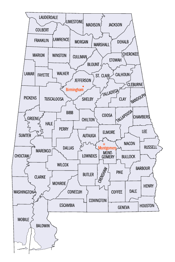
Overview and contemporary role
Counties in Alabama serve as local units for law enforcement, courts, property records, tax collection, public health, road maintenance and other services. Each county typically has an elected commission or board of supervisors and additional elected officers such as sheriff and probate judge. County seats—municipal centers that host courthouses and administrative offices—mark where many public records and services are concentrated. Population and area differ greatly: some counties encompass large rural tracts while others contain major urban centers.
Historical development
The land that became Alabama was contested and settled by European powers before joining the United States. Spain claimed parts as Spanish Florida, and England asserted claims as the Province of Carolina. The first enduring European settlement in the region was established by the French along the Mobile River in the early eighteenth century. After the American Revolutionary War (see Revolutionary War), the area passed through territorial reorganizations: most of the upper portion became part of the federal Mississippi Territory while lands to the south and west remained under other colonial claims. In 1817 the western part of the Mississippi Territory became the State of Mississippi, leaving the remainder as the Alabama Territory, which in turn laid out additional county divisions.
When Alabama entered the Union in 1819 as the 22nd state, county creation continued as population expanded and as Native American lands were ceded under treaties and federal policies such as the Indian Removal Act. The number of counties grew steadily: from 29 in 1820 to 36 in 1830, 49 in 1840, 52 in 1850, 65 by 1870, and the current complement of 67 by 1903.
Geography, population and notable distinctions
Counties differ in size and demographic weight. The largest county by land area is Baldwin County, which stretches across substantial coastal and inland terrain, while the smallest county by land area is Etowah County. Population figures shift with each decennial census; historically Jefferson County (Jefferson) has been among the most populous, while some rural counties such as Greene County have had comparatively small populations. Typical references report average county land area around 757 square miles (sq mi) or roughly 1,960.6 square kilometers (km2), but individual counties differ substantially from those averages.
Administration, identification and useful facts
Every county is identified by a unique Federal Information Processing Standard (FIPS) code used by federal and state agencies for statistics and record linking. These numerical identifiers are standard across official datasets and appear in census materials and program reporting. Alphabetical ordering of county names for administrative lists follows conventional spelling rules; for example, in some federal lists St. Clair County precedes Shelby County because of how punctuation and spacing are handled in sorting.
Understanding Alabama's counties helps interpret local governance, electoral districts, historical settlement patterns and regional differences in economy and landscape. For further reading on specific counties, legal responsibilities, demographic trends and maps, official state and county websites and census data provide current, county-level details and are recommended as primary sources.
Questions and answers
Q: How many counties does the U.S. state of Alabama have?
A: Alabama has sixty-seven counties.
Q: What is the oldest county in Alabama?
A: The oldest county in Alabama is Washington County, created on June 4, 1800.
Q: What was the first permanent colony established in what is now Alabama?
A: The first permanent colony was made by the French on the banks of the Mobile River in 1702.
Q: When did Mississippi become a state?
A: In 1817, the western part of the territory became the State of Mississippi.
Q: How many counties were there in Alabama by 1840?
A: By 1840, 49 counties had been created in Alabama.
Q: What is the average population for each county according to 2006 U.S Census estimates?
A: According to 2006 U.S Census estimates, the average population of Alabama's sixty-seven counties was 68,642 people.
Q: What is Baldwin County's land area size and what is Etowah County's land area size?
A: Baldwin County has 1,596 sq mi (4,133.6 km2) and Etowah County has 535 sq mi (1,385.6 km2).
Related articles
Author
AlegsaOnline.com Counties of Alabama: overview, history, and notable facts Leandro Alegsa
URL: https://en.alegsaonline.com/art/124597
Sources
- countystate.info : "CountyState.info Alabama"
- epa.gov : "EPA County FIPS Code Listing"
- naco.org : "NACo - Find a county"
- 15q.net : "Alabama County Codes"
- archives.state.al.us : "Alabama Counties"
- factfinder2.census.gov : "American FactFinder"
- census.gov : "2010 Census U.S. Gazetteer Files"
- coffeecounty.us : "History of Coffee County"