Bludenz
![]()
The title of this article is ambiguous. For the last count of Bludenz, see Albrecht III of Werdenberg-Heiligenberg-Bludenz.
Bludenz (standard German pronunciation: [ˈblu:dents], ![]() , local Vorarlberg dialect: [ˈbludats]) is a town in the Austrian state of Vorarlberg. The town is the seat of the district authority of Bludenz and as of 30 June 2018, with 14577 (main residences) plus 1098 (other residences) inhabitants, it is the sixth largest municipality in Vorarlberg.
, local Vorarlberg dialect: [ˈbludats]) is a town in the Austrian state of Vorarlberg. The town is the seat of the district authority of Bludenz and as of 30 June 2018, with 14577 (main residences) plus 1098 (other residences) inhabitants, it is the sixth largest municipality in Vorarlberg.

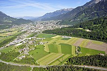
Aerial view of the city of Bludenz in northwestern direction; in the foreground the district Brunnenfeld and the S16, in the middle ground the Arlbergbahn is visible running along the edge of the forest.
History
Early days
The finds at the Montikel (town hill) make Bludenz an important archaeological site in western Austria. The steeply sloping rock supported a Bronze Age hilltop settlement that remained inhabited until the end of the La Tène period. In the area "Unter dem Stein" (today Untersteinstraße) at the southern foot of the Montikel, weapons and tools made of iron as well as ornaments made of bronze were found during excavation work from 1830 to 1935.
Animal and human bones were embedded in a fire horizon uncovered in 1900. Ceramic remains, weapons (spearheads, lance shoes, halberd axes, sword fragments, sword scabbards and a helmet fragment), implements (knives, sickles, keys, rings, chariot fittings, snaffles, an axe and a hearth shovel), jewellery (brooches, needles, bracelets and belt accessories) are of the Celtic or Inner Alpine-Rhaetian type. The period is assumed to be from the 5th to the 1st century A.D. and is seen from today's point of view as the deposition of a sacrificial site. Most of the find material has not been preserved and can only be reconstructed from earlier records.
Bludenz from 830
The village of Bludenz was first documented in the year 830 in the so-called "Churrätischen Reichsurbar" (Surbar of the Churraean Empire) under the name versions "Pludono" and "Pluteno", which were used next to each other. In 842, the settlement is mentioned in the Carolingian property register as "Pludeno". The names are presumably of pre-Roman origin and derive from the Indo-Germanic root term "pleud", which can be translated as "flow". In view of the extensive marshes on the Ill, Latin "ad paludines" ("by the marshes") is also discussed as the donor of the name.
From 1098 to 1629, the plague occurred nineteen times in Bludenz - it claimed a particularly large number of victims in 1143 and 1591.
The town of Bludenz was founded by the Werdenbergs in 1265, and Hugo I of Werdenberg granted the town charter in 1274. Between 1222 and 1245, the Counts of Werdenberg built a castle complex as the centre of the Count of Werdenberg and Holy Hill dominion, or the dominion of Bludenz, on the site of which Gayenhofen Castle now stands. Duke Friedrich IV ("with the empty pocket") fled over the Arlberg to Tyrol after his ostracism at the Council of Constance. In the process, he spent 30 March 1416 in Bludenz (reminiscence in legends of his request for admission at the Upper Gate).
In 1420, the town and dominion of Bludenz passed to Austria. In this year, emissaries from Bludenz and the Montafon paid homage to their new lord Duke Friedrich IV, who confirmed their privileges. The entire mining area in Montafon, Walgau, around Nüziders as well as in Klostertal only belonged to Austria after the destruction of Sonnenberg Castle in 1473.
In 1525 the Reformation failed in Bludenz. The Habsburgs ruled Bludenz alternately from Tyrol and Anterior Austria (Freiburg im Breisgau).
In 1444 and again in 1491 the town burned down together with the gates, the castle (later baroque castle) and the St. Laurentius church.
In the first half of the 16th century there was a report of a smelting works in Bludenz, which smelted ores from the Lobinger (Kristbergsattel) and Kristberg, but also ores from the area around Nüziders and Bludenz.
On 1 November 1638, another fire destroyed almost the entire town; only the Upper Gate with two neighbouring houses as well as the church and castle were spared from the flames. In 1682 another fire destroyed a large part of the wooden houses in the town.
In October 1730, the Tyrolean imperial baron Franz Andreas von Sternbach, who had achieved great wealth as a mining entrepreneur, acquired the united lordship of Bludenz-Sonnenberg.
19th and 20th century
From 1806 to 1814 the town belonged to Bavaria, then back to Austria. When it was transferred to Bavaria in 1806, Bludenz became part of the Sonnenberg district court, whose seat was Nüziders until 1810 and then the town. After the return of Vorarlberg to the Austrian state in 1814, the Lords of Sternbach were no longer granted high jurisdiction. In 1854, the remaining feudal estate was dissolved - Gayenhofen Castle, however, remained their private property until 1936.
In 1872, the town received its first railway connection through the Lindau-Bludenz railway line.
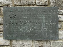
On 23 August 1873, the merger of the Austrian and German Alpine Associations to form the German and Austrian Alpine Association (DuOeAV) took place in the former Schützenhaus next to Gayenhofen Castle.
After the construction of the Buntweberei (1871) and in the wake of the construction of the Arlbergbahn (1884), a large number of immigrants from Trentino, the then "Welschtirol", settled in Bludenz. The part of town inhabited mainly by them was soon called the "Welsches Viertel". Around 1900, almost one fifth of the population of Bludenz was of Italian mother tongue.
When Vorarlberg tried to separate from the newly formed Republic of German Austria and join the Swiss Confederation at the time of the worst economic hardship, Bludenz was the only larger town in the state to vote against it in May 1919, along with two villages in the Bregenzerwald.
After the annexation of Austria to the German Reich in 1938, Bludenz became the district town in the Reichsgau Tirol-Vorarlberg. The district leaders were Hans Bernard and Wernfried Richter. The Hitler-Mussolini Agreement in 1939 brought about the establishment of the South Tyrolean Settlement.
The tower of the Heilig-Kreuz-Kirche (Church of the Holy Cross) served as an air observation post from 1943 and an air guard was installed on the Muttersberg. In 1943/1944, anti-aircraft guns were stationed at the Bürser transformer station and at the Bludenz railway station, and an air-raid shelter was built in the Unterstein and in the Mokry. Bludenz was liberated from the Nazi dictatorship by French troops in May 1945 and was subsequently part of the French occupation zone in Austria from 1945 to 1955. In the district of Bludenz, in the camps Mokry and Rungelin (on the area of today's Beim Kreuz settlement) there were still 182 political prisoners in June 1946. Some inmates of the Rungelin camp are said to have laid out the so-called "political path" in the Letziwald above Lorüns and to have carried out forestry work.
21st century
Since the beginning of the 21st century Bludenz has been advertising with the title "Alpine Town Bludenz".

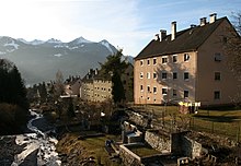
South Tyrolean settlement from the Daneubrücke. The bed enclosures and other structures in the vicinity of the Galgentobelbach stream have since been demolished in favour of better drainage.

Commemorative plaque commemorating the union of OeAV and DAV on August 23, 1873 at the southern staircase to the Schloßhotel (next to Schloß Gayenhofen)

Bludenz around 1643 (copper engraving by Merian) with the Oberes Tor (front), the Ill (right), the Montafon (back right) and the Klostertal (back left).
Population
Population development
Population development in Bludenz
Source: Statistics Austria
In 1967, about half of the inhabitants were born in the city. 40 percent came from the rest of Austria and ten percent from abroad. Especially in the 1970s and 1980s there was a strong influx of foreign workers, who mainly found employment in the industrial companies.
At the end of 2002, the proportion of foreigners was 16.9 percent. Together with the neighbouring municipalities, especially Nüziders and Bürs, Bludenz forms a uniform settlement and economic area with about 25,000 inhabitants.

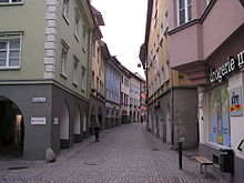
The middle section of Werdenbergerstrasse designed as a pedestrian zone before the reconstruction of the Kronenhaus (house behind the post)
Search within the encyclopedia